

December 2015 -Year Ends As One Of Wettest On Record
-
MontgomeryCoWx

- Posts: 2356
- Joined: Wed Dec 14, 2011 4:31 pm
- Location: Weimar, TX
- Contact:
Per 12z GFS, I get my 2nd freeze of the season Tuesday Morn.
Team #NeverSummer
-
srainhoutx

- Site Admin

- Posts: 19616
- Joined: Tue Feb 02, 2010 2:32 pm
- Location: Maggie Valley, NC
- Contact:
That's an impressive amount of snow via the 12Z GFS. Certainly looks like we could see some very chilly air filtering into the Region in the wake of this powerful Winter Storm.
- Attachments
-
Carla/Alicia/Jerry(In The Eye)/Michelle/Charley/Ivan/Dennis/Katrina/Rita/Wilma/Humberto/Ike/Harvey
Member: National Weather Association
Facebook.com/Weather Infinity
Twitter @WeatherInfinity
Member: National Weather Association
Facebook.com/Weather Infinity
Twitter @WeatherInfinity
-
MontgomeryCoWx
- Posts: 2356
- Joined: Wed Dec 14, 2011 4:31 pm
- Location: Weimar, TX
- Contact:
Last 4 runs, don't have me getting out of the 40s next week, with 4 consecutive freezes in the Lake Conroe area.srainhoutx wrote:That's an impressive amount of snow via the 12Z GFS. Certainly looks like we could see some very chilly air filtering into the Region in the wake of this powerful Winter Storm.
NYE is going to feel great. Bringing the heaters and bourbon out in full force!
Team #NeverSummer
Freeze line getting pretty close to the Golden Triangle area....
http://www.pivotalweather.com/model.php ... r=sc&dpdt=
http://www.pivotalweather.com/model.php ... r=sc&dpdt=
I'll be turning on the heat,as for the bourbon it's coming out too.I'm on vacation.MontgomeryCoWx wrote:Last 4 runs, don't have me getting out of the 40s next week, with 4 consecutive freezes in the Lake Conroe area.srainhoutx wrote:That's an impressive amount of snow via the 12Z GFS. Certainly looks like we could see some very chilly air filtering into the Region in the wake of this powerful Winter Storm.
NYE is going to feel great. Bringing the heaters and bourbon out in full force!
-
srainhoutx
- Site Admin
- Posts: 19616
- Joined: Tue Feb 02, 2010 2:32 pm
- Location: Maggie Valley, NC
- Contact:
Digital snowfall via the 12Z GFS through New Years Day. And the crazy Canadian has a Hard Freeze possible with temperatures in the upper teens to low 20's across the Hill Country early morning on January 2nd.
- Attachments
-
Carla/Alicia/Jerry(In The Eye)/Michelle/Charley/Ivan/Dennis/Katrina/Rita/Wilma/Humberto/Ike/Harvey
Member: National Weather Association
Facebook.com/Weather Infinity
Twitter @WeatherInfinity
Member: National Weather Association
Facebook.com/Weather Infinity
Twitter @WeatherInfinity
Looks like some serious changes on the way, at least new years evish through for 8-10 days of 2016.
some serious weather for a busy travel week - stay safe everyone !
http://www.spc.noaa.gov/
For tornado/severe thunderstorm watches, mesoscale discussions, convective outlooks, fire weather outlooks:
http://www.spc.noaa.gov/products/spcrss.xml
For tornado/severe thunderstorm watches and watch status reports only:
http://www.spc.noaa.gov/products/spcwwrss.xml
For Particularly Dangerous Situation (PDS) tornado/severe thunderstorm watches only:
http://www.spc.noaa.gov/products/spcpdswwrss.xml
For mesoscale discussions only:
http://www.spc.noaa.gov/products/spcmdrss.xml
For convective outlooks only:
http://www.spc.noaa.gov/products/spcacrss.xml
For experimental public severe weather outlook multimedia briefings only:
http://www.spc.noaa.gov/products/spcmbrss.xml
For fire weather forecasts only:
http://www.spc.noaa.gov/products/spcfwrss.xml
-
srainhoutx
- Site Admin
- Posts: 19616
- Joined: Tue Feb 02, 2010 2:32 pm
- Location: Maggie Valley, NC
- Contact:
We are getting some agreement via the computer guidance that a slightly more wound up and Southern tracking Winter Storm will approach our Region during Christmas Day and the weekend. While it is still too soon to know the exact track, meso features as well as actual temperature profiles for a shortwave over the NE Pacific Ocean, the trends point to a very active and dynamic Winter Storm impacting a large portion of the Southern/Central Rockies, Southern/Central Plains and areas N and E.
- Attachments
-
-
Carla/Alicia/Jerry(In The Eye)/Michelle/Charley/Ivan/Dennis/Katrina/Rita/Wilma/Humberto/Ike/Harvey
Member: National Weather Association
Facebook.com/Weather Infinity
Twitter @WeatherInfinity
Member: National Weather Association
Facebook.com/Weather Infinity
Twitter @WeatherInfinity
-
srainhoutx
- Site Admin
- Posts: 19616
- Joined: Tue Feb 02, 2010 2:32 pm
- Location: Maggie Valley, NC
- Contact:
Afternoon briefing from Jeff:
Highly active “spring like” weather pattern will bring severe weather and flooding rainfall to the southern US over the next 5 days.
Many locations will set record high temperatures on Christmas Eve and Christmas Day east of the Rockies.
Today:
Strong upper level storm system moving over the central plains this morning is pushing a weak cool front across SE TX currently. Temperatures ahead of this boundary under clearing skies are soaring into the lower 80’s and it looks like we will be approaching record values this afternoon. Most low level moisture is being scoured out to our east currently allowing the clearing skies and satellite images and coastal cameras show the dense sea fog bank as broken up for the time being.
A very significant tornado outbreak is underway over the lower MS valley and will continue into the evening hours with multiple long tracked violent tornadoes possible especially over N MS into W TN. This is a climo favored tornado setup for late December in the mid South and such outbreaks can result in high fatality rates especially after dark in this area of the country. Given breaks in the overcast over NE LA into N MS and N AL over the last few hours…expect significant supercell development within the next 1-2 hours with resulting damaging tornadoes across that region.
Christmas Eve:
Weak boundary stalls near the coast tonight and high resolution models show a sea fog bank forming over the coastal waters south of Lake Charles and Sabine Pass late tonight and moving westward early Thursday morning. Sea fog bank should arrive into the upper TX coast by 200-600am and spread inland during the early morning hours. This would be along and south of a returning warm front which will bring a very warm and muggy air mass northward across SE TX on Thursday. Meso models show shower breaking out under this returning moisture by midday and continuing into the evening hours. Increasing clouds and possible rain showers may help keep temperatures from getting to out of hand on Thursday…but any breaks in the cloud cover will result in 80 degree readings which are nearing records for the date.
Christmas Day:
Short wave will ripple across the area in the SW upper air flow aloft as a powerful storm system digs into the SW US. Will need to key in on Christmas morning for a period of potential shower and thunderstorms. Increasing low level jet and firmly entrenched high moist air mass does support a low end severe weather threat east of a line from College Station to Galveston. Any isolated severe weather should be short lived and contained to the morning hours. Periods of showers and thunderstorms will then move inland from the Gulf of Mexico through the day and into Christmas night as warm air advection and the low level jet increases. Temperatures will be in the muggy 70’s to near 80 during the day with lows near 70. Currently looking like 2015 will go down as one of the top 10 warmest Christmas Days on record and could even be in the top 5. Record high for Dec 25 is 82 for IAH
Weekend:
Powerful storm system will move across TX with severe weather and heavy rainfall
Deepening upper level trough digging into the SW US late this week will dig even further southward into N MX by late Friday into Saturday. Surface low pressure will develop under the strong upper level jet forcing over SW TX early Saturday and move ENE to NE across the state. Warm sector air mass east of I-35 becoming increasing unstable during the day and with large scale lift increasing expect widespread showers and thunderstorms to stream northward across the area. Wind shear values increase with time as the upper jet cores into the region by Saturday afternoon. Will have to watch for discrete cells over the area Saturday afternoon which could pose a tornado threat. We have seen this setup a few times this fall, but only two events have actually produced tornadoes (Halloween and December 12).
Upper trough takes a negative tilt orientation as it ejects into TX late Saturday with strong jet dynamics overspreading the warm sector. Strong Canadian cold front will surge down the plains and across TX Saturday night slicing into this primed air mass. Expect a fairly extensive squall line to develop and cross the region Saturday night into Sunday with all severe weather modes possible. PWS soar to nearly 2.0 inches which would be record values (sound familiar) for this time of year and this would certainly support a widespread heavy rainfall threat. With so much warmth and humidity in place in the downstream air mass combined with the strong dynamics of winter storm systems…it is going to be a very active period across the southern plains and southern US this weekend. SPC has 15% probabilities for severe weather days 4/5 (Sat/Sun) over central and eastern TX and this system will certainly support a category “enhanced” and “slight” risk outlines by Day 3 (tomorrow) for portions of the outline area.
Large scale blizzard will develop on the backside of the upper level trough over NW TX and into NW OK Sunday with significant accumulation of snowfall expected.
Cold air will crash through SE TX Sunday with temperatures in the 70’s falling rapidly into the 40’s. Highs next Monday look locked in the 40’s under gusty north winds and clouds…as winter returns to the region.
Hydro:
Grounds remain saturated from the recent rainfall and many rivers are either in flood or well above base flow especially across the eastern portions of TX. Widespread rainfall amounts this weekend of 2-3 inches and isolated totals upwards of 6-8 inches especially over N TX will only result in additional river flooding. Area reservoirs and lakes continue to attempt to evacuate their flood pools and drawn down their conservation pools to build as much capacity into storage ahead of this storm system…but flooding is almost going to certainly result on rivers that are already near or over capacity (Trinity, Navasota, Neches, Sabine).
Carla/Alicia/Jerry(In The Eye)/Michelle/Charley/Ivan/Dennis/Katrina/Rita/Wilma/Humberto/Ike/Harvey
Member: National Weather Association
Facebook.com/Weather Infinity
Twitter @WeatherInfinity
Member: National Weather Association
Facebook.com/Weather Infinity
Twitter @WeatherInfinity
updated http://www.spc.noaa.gov/products/outlook/pwo.html and http://www.spc.noaa.gov/products/outlook/day1otlk.html
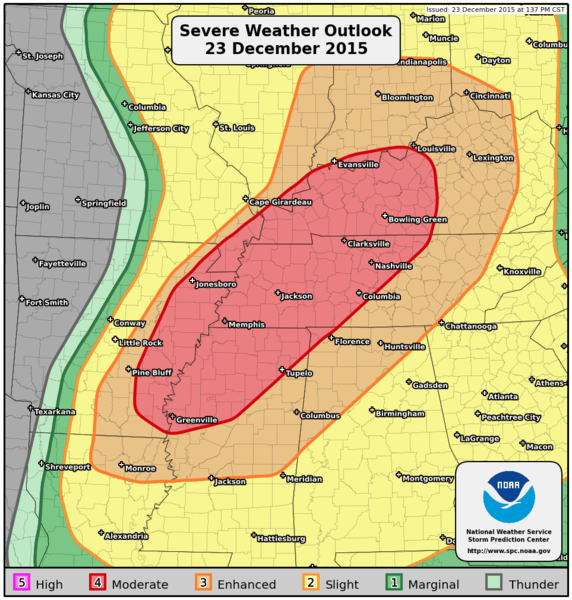
PUBLIC SEVERE WEATHER OUTLOOK
NWS STORM PREDICTION CENTER NORMAN OK
0147 PM CST WED DEC 23 2015
...Severe thunderstorms expected over parts of the Lower/Middle Mississippi Valley and Tennessee Valley this afternoon and tonight...
* LOCATIONS...
Kentucky
Tennessee
Far southern Indiana
Far southern Illinois
Southeast Missouri
Northern Mississippi
Eastern Arkansas
Northwest Alabama
* HAZARDS...
Widespread damaging winds, some hurricane force
Several tornadoes, a few intense
Isolated large hail
* SUMMARY...
An outbreak of severe thunderstorms and tornadoes is forecast today into tonight from the Ohio Valley into the Tennessee and lower Mississippi Valleys. The greatest risk for a few intense, long-tracked tornadoes will exist over western Tennessee into northern Mississippi and eastern Arkansas this afternoon into tonight.
Preparedness actions...
Review your severe weather safety procedures for the possibility of dangerous weather today. Stay tuned to NOAA Weather Radio, weather.gov, or other media for watches and warnings. A watch means that conditions are favorable for severe thunderstorms over the next several hours. If a severe thunderstorm warning is issued for your area, move to a place of safety, ideally in an interior room on the lowest floor of a sturdy building.
&&
..Guyer.. 12/23/2015


It is warm right now. Usually with strong El Nino, December tends to be warm.
The weather really blows right now. The weeds in my yard are going crazy and the mosquitoes are biting and I'm being forced to keep the air conditioner running. I hope we get some kind of arctic transition to take hold and soon.

That tongue of flurries approaches Huntsville and Conroe. As the low tracks up - 20-30 miles S/E and a slight delay could make a big difference - not getting my hopes up...too much.srainhoutx wrote:That's an impressive amount of snow via the 12Z GFS. Certainly looks like we could see some very chilly air filtering into the Region in the wake of this powerful Winter Storm.

The cold is coming...Sunday is the transition day from summer to winter...a powerful winter storms will bring a blizzard to NW TX and severe weather to E TX.Cromagnum wrote:The weather really blows right now. The weeds in my yard are going crazy and the mosquitoes are biting and I'm being forced to keep the air conditioner running. I hope we get some kind of arctic transition to take hold and soon.
How much snow will Oklahoma City get? The latest GFS run seems to show 16-18 inches but is it overdoing it?
I love this meteorologist's statement in the long range WPC forecast discussion, great discussion as a whole:
http://www.wpc.ncep.noaa.gov/discussion ... isc=pmdepd
IF I THOUGHT A STRAIGHT 100% MODEL WOULD BE ABLE TO PINPOINT EVERY DETAIL--- I WOULD USE IT
http://www.wpc.ncep.noaa.gov/discussion ... isc=pmdepd
IF I THOUGHT A STRAIGHT 100% MODEL WOULD BE ABLE TO PINPOINT EVERY DETAIL--- I WOULD USE IT
This looks very interesting for us in S.E, Tx Jan 7
http://www.pivotalweather.com/model.php ... r=sc&dpdt=
http://www.pivotalweather.com/model.php ... r=sc&dpdt=
-
srainhoutx
- Site Admin
- Posts: 19616
- Joined: Tue Feb 02, 2010 2:32 pm
- Location: Maggie Valley, NC
- Contact:
While it is fun to speculate about what may or may not happen 2 weeks from today and we have attempted to look ahead to what may well be a significant pattern change as we turn the calendar to January, let's focus on the weekend ahead...for now. Feel free to start a new Topic for January 2016.snowman65 wrote:This looks very interesting for us in S.E, Tx Jan 7
http://www.pivotalweather.com/model.php ... r=sc&dpdt=
Concern is increasing across Central, SE, East Texas into Western Louisiana for severe weather as a triple point develops near the Hill Country ( San Antonio/San Marcos/Austin/College Station) Saturday night into Sunday with a surface low tracking from Brownsville to Houston and on NE to near Texarkana which is worrisome for the potential for severe thunderstorms associated with a strong squall line where all modes of severe weather looks very possible.
Will take a closer look at both the short and longer range forecast this afternoon after all the 12Z guidance is in. That said January is beginning to look much more like Winter versus the Spring like weather we have been experiencing.
- Attachments
-
-
Carla/Alicia/Jerry(In The Eye)/Michelle/Charley/Ivan/Dennis/Katrina/Rita/Wilma/Humberto/Ike/Harvey
Member: National Weather Association
Facebook.com/Weather Infinity
Twitter @WeatherInfinity
Member: National Weather Association
Facebook.com/Weather Infinity
Twitter @WeatherInfinity