
December 2015 -Year Ends As One Of Wettest On Record
-
Katdaddy

- Global Moderator

- Posts: 2502
- Joined: Thu Feb 04, 2010 8:18 am
- Location: League City, Tx
- Contact:
Near record temps across SE TX today. The SPC has shifted the slight risk area to N TX, OK, and S KS tomorrow while a marginal risk area exists across Central, E, and SE TX. In addition, this morning's Houston-Galveston AFD mentions the possibility of a Flash Flood Watch with some areas seeing 4-6" totals by Sunday morning due to deep tropical moisture. It may be December but it feels like April.
- Attachments
-
- Screen Shot 2015-12-11 at 5.26.08 AM.png (16.69 KiB) Viewed 4158 times
-
- Screen Shot 2015-12-11 at 5.26.16 AM.png (13.75 KiB) Viewed 4158 times
much easier to see the QPF for your area on West Gulf RFC's site map feature http://www.srh.noaa.gov/wgrfc, it will be a soggy weekend
and I don't care how many local stations say there's no pollen, they're wrong... I can feel the juniper/cedar 100 miles away, it's bothered me all week & it's kickin' me after yesterday's winds http://www.pollen.com/allergy-weather-forecast.asp

at least the rain will knock it down for a bit, anyway
and I don't care how many local stations say there's no pollen, they're wrong... I can feel the juniper/cedar 100 miles away, it's bothered me all week & it's kickin' me after yesterday's winds http://www.pollen.com/allergy-weather-forecast.asp
at least the rain will knock it down for a bit, anyway
Last edited by unome on Fri Dec 11, 2015 9:08 am, edited 1 time in total.
Doesn't look like this is going to pan out. Already half way through December and nothing has been cool, and the forecast doesn't show any changes ahead, that I can see.
- Attachments
-
- December outlook
- dec.jpg (21.03 KiB) Viewed 4090 times
-
MontgomeryCoWx

- Posts: 2356
- Joined: Wed Dec 14, 2011 4:31 pm
- Location: Weimar, TX
- Contact:
3 things ...
1). It's not Winter yet
2). The holidays look cool to cold
3). In Western strong Nino's, December is typically warm and January-March gives us lots of chances at Winter weather compared to normal....
1). It's not Winter yet
2). The holidays look cool to cold
3). In Western strong Nino's, December is typically warm and January-March gives us lots of chances at Winter weather compared to normal....
Team #NeverSummer
-
srainhoutx

- Site Admin

- Posts: 19616
- Joined: Tue Feb 02, 2010 2:32 pm
- Location: Maggie Valley, NC
- Contact:
Morning briefing from Jeff:
Heavy rainfall and severe weather possible this weekend.
A strong storm system will move into TX over the next 48 hours resulting in a good chance of rainfall and thunderstorms. Upper level trough along the US west coast will dig into the SW US and intensify over the next 24 hours. This will in turn lead to an increase in moisture advection across TX with the formation of a 45-55kt low level jet by tonight. Lead short wave trough will eject out of the main trough Saturday afternoon and spread lift across a moist SE TX air mass. Expect numerous thunderstorms to develop ahead of this feature post noon Saturday into the evening hours. Some of these storms could be strong with strong winds. Heavy rainfall will also becoming increasingly likely as PWs soar into the 2.0 inch range which is over the daily record values for both LCH and CRP for this time of year.
Expect a brief break late Saturday evening followed by a second round of storms Sunday morning ahead of the main trough axis and cold front. Low level shear values are favorable for low level storm rotation Saturday night, but instability is generally low. Cannot rule out a few damaging winds or tornadoes in this setup as cold season events near the Gulf coast don’t require much instability to produce severe weather. Air mass will certainly support heavy to excessive rainfall with potential for a period of cell training from near Matagorda Bay to Huntsville. A little concerned about the forecasted very high PW air mass with the strong lift and potential for training. May need a flash flood watch at some point if confidence in cell training increases.
Expect storms totals of 1-3 inches with isolated amounts of 4-6 inches. While grounds have had a bit of time to dry over the last several days…they are generally still soggy and rainfall of this magnitude will result in run-off. Main concern is for area rivers which are already high and given the expected widespread rainfall amounts, especially over the Trinity and Brazos basins additional rises will be possible into next week. High hourly rainfall rates will also likely present a urban flood threat with respect to street flooding.
Hydro:
Flood control operations have begun on both the Trinity and Brazos River basins to help evacuate high storage pools in area reservoirs due to the upcoming rainfall event. Basin average amounts over the next 48-hrs will almost certainly lead to additional main stem rises on the Trinity and Brazos basins and additional flood gate operations at area lakes and reservoirs.
Extended:
Pattern looks to be transitioning back to active with another storm system coming in stronger in the models by the middle of next week which may also grab a good shot of cold air.
Carla/Alicia/Jerry(In The Eye)/Michelle/Charley/Ivan/Dennis/Katrina/Rita/Wilma/Humberto/Ike/Harvey
Member: National Weather Association
Facebook.com/Weather Infinity
Twitter @WeatherInfinity
Member: National Weather Association
Facebook.com/Weather Infinity
Twitter @WeatherInfinity
Soo what affects will this have on our weather? If any?
http://www.msn.com/en-us/weather/topsto ... ailsignout
http://www.msn.com/en-us/weather/topsto ... ailsignout
-
srainhoutx
- Site Admin
- Posts: 19616
- Joined: Tue Feb 02, 2010 2:32 pm
- Location: Maggie Valley, NC
- Contact:
davidiowx wrote:Soo what affects will this have on our weather? If any?
http://www.msn.com/en-us/weather/topsto ... ailsignout
I mentioned this storm system a couple of days ago and suggested we may need to monitor things particularly across the West and possibly into the Plains in about a week to 10 days. There was a fairly significant shift in some of the teleconnection indices such as a negative AO/-PNA/-EPO regime that could signal a rather cold and unsettled pattern that may extend into Texas. We will see. There is a lot of volatility in the guidance right now and I expect this intense storm system to be one of the contributors to the run to run volatility we are witnessing. The powerful cyclone is expected to become stronger than Extra Tropical Storm Nuri that reshuffled the entire weather pattern last year when it bombed in the Bering Sea.
Carla/Alicia/Jerry(In The Eye)/Michelle/Charley/Ivan/Dennis/Katrina/Rita/Wilma/Humberto/Ike/Harvey
Member: National Weather Association
Facebook.com/Weather Infinity
Twitter @WeatherInfinity
Member: National Weather Association
Facebook.com/Weather Infinity
Twitter @WeatherInfinity
Thanks! Great answer as always!
-
srainhoutx
- Site Admin
- Posts: 19616
- Joined: Tue Feb 02, 2010 2:32 pm
- Location: Maggie Valley, NC
- Contact:
Need to keep an eye on the overnight guidance for any subtle changes in the sensible weather expected tomorrow afternoon and particularly tomorrow night into early Sunday morning. The Weather Prediction Center has outlined a Slight and Moderate Risk for Excessive Rainfall across portions of our Region.
- Attachments
-
-
Carla/Alicia/Jerry(In The Eye)/Michelle/Charley/Ivan/Dennis/Katrina/Rita/Wilma/Humberto/Ike/Harvey
Member: National Weather Association
Facebook.com/Weather Infinity
Twitter @WeatherInfinity
Member: National Weather Association
Facebook.com/Weather Infinity
Twitter @WeatherInfinity
-
srainhoutx
- Site Admin
- Posts: 19616
- Joined: Tue Feb 02, 2010 2:32 pm
- Location: Maggie Valley, NC
- Contact:
Certainly a complicated setup across the Region. Several shortwaves with an Eastern Pacific connection as well as a stout low level jet off the Gulf typically suggests the potential for heavy rainfall where training heavier storms develop. Also we can see the big cyclone approaching the Aleutians with its cirrus canopy. The 18Z surface charts for the Bering Sea indicated Hurricane force winds and freezing sea spray.

- Attachments
-
Carla/Alicia/Jerry(In The Eye)/Michelle/Charley/Ivan/Dennis/Katrina/Rita/Wilma/Humberto/Ike/Harvey
Member: National Weather Association
Facebook.com/Weather Infinity
Twitter @WeatherInfinity
Member: National Weather Association
Facebook.com/Weather Infinity
Twitter @WeatherInfinity
-
MontgomeryCoWx
- Posts: 2356
- Joined: Wed Dec 14, 2011 4:31 pm
- Location: Weimar, TX
- Contact:
I could go for a severely negative EPO and the NAO tanking.
How about some 20 degree weather Christmas week? That sounds lovely.
How about some 20 degree weather Christmas week? That sounds lovely.
Team #NeverSummer
MontgomeryCoWx wrote:I could go for a severely negative EPO and the NAO tanking.
How about some 20 degree weather Christmas week? That sounds lovely.
Look at the 18Z GFS.
getting woken by the a/c unit kicking on, not what you expect mid-December
from http://www.coolwx.com/ , some record US temps the last day/week
from http://www.coolwx.com/ , some record US temps the last day/week
-
srainhoutx
- Site Admin
- Posts: 19616
- Joined: Tue Feb 02, 2010 2:32 pm
- Location: Maggie Valley, NC
- Contact:
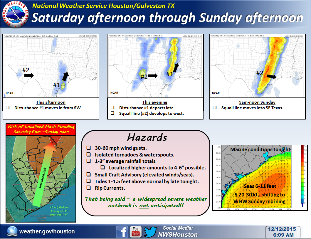
Saturday morning briefing from Jeff:
Heavy rainfall and slight chance of severe thunderstorms likely this afternoon into Sunday midday.
Upper level trough has dug into the SW US and will begin to eject eastward into the plains today. Lead short wave currently exiting NC MX into SW TX will arrive into SE TX this afternoon. Impressive low level jet will develop today with 45-50kts by this afternoon increasing to a very strong 60kts tonight. This will pull copious tropical moisture from the southern Gulf of Mexico northward into SE TX today. PWS are expected to rise to record values of 1.9-2.1 inches. Daily PW record for CRP is 1.83 inches. Saturated air column points strongly toward heavy rainfall.
Lift from lead short wave will arrive into SE TX in the noon-300pm time period and expect to see a rapid increase in showers and thunderstorms moving quickly northward from the middle TX coast into SE TX. Latest radar trends out of CRP suggest this is starting to happen with shallow showers developing SSW of VCT at this time. TX TECH model from 18Z yesterday (no overnight runs) showers these storms congealing into a solid line from near Wharton to Waller to Huntsville and there is some support of this idea from the 11Z HRRR which shows less organized training from near Richmond to Huntsville. Would be concerned if the TX TECH model starts to verify as a solid line of training thunderstorms late this afternoon and evening would certainly raise a flash flood threat. Think this model may be overdoing the organization of the development as there is currently no surface boundary to anchor convection along. With that said, if storms do develop and intensify as much as this model suggests, they could create their own low level boundary which given the orientation on the model would be nearly perpendicular to the low level inflow which is a good heavy rainfall setup. Could also see a slight damaging wind threat with these storms this afternoon as the low level jet increases. It is not going to take much to bring some of the wind energy just above the surface down to the ground.
Round 2 will move into the area between midnight and 600am Sunday morning. May see a brief lull in the activity late this evening (900pm-midnight) as the lead shortwave moves NE, but strong lift with the main upper trough and surface cold front will arrive early Sunday morning. Low level jet is maximized at nearly 60kts ahead of this line, but instability is really lacking….only looking at 500 J/kg of CAPE. The lack of instability should help keep the severe threat in check, but cannot deny the large amounts of wind energy just off the surface and it will not take much to bring this down to the ground in the form of 50-65mph wind gusts. Will also look at another bout of heavy rainfall with this line also, but the forward storm motions should be on the order of 25-40mph which should limit the duration of any heavy rainfall.
Rainfall amounts of 1-3 inches are certainly possible with isolated totals upwards of 4-6 inches under periods of training cells. Best estimate of the highest potential for cell training will be this afternoon and evening in a SSW to NNE corridor from Wharton to Angleton northward to between College Station and Huntsville.
Near record high temperatures today will fall quickly behind the cold front early Sunday and much of the day will be spent in the 50’s with clouds clearing late in the afternoon.
Carla/Alicia/Jerry(In The Eye)/Michelle/Charley/Ivan/Dennis/Katrina/Rita/Wilma/Humberto/Ike/Harvey
Member: National Weather Association
Facebook.com/Weather Infinity
Twitter @WeatherInfinity
Member: National Weather Association
Facebook.com/Weather Infinity
Twitter @WeatherInfinity
-
srainhoutx
- Site Admin
- Posts: 19616
- Joined: Tue Feb 02, 2010 2:32 pm
- Location: Maggie Valley, NC
- Contact:
NWS STORM PREDICTION CENTER NORMAN OK
1025 AM CST SAT DEC 12 2015
VALID 121630Z - 131200Z
...THERE IS A SLGT RISK OF SVR TSTMS THIS AFTERNOON THROUGH TONIGHT
FOR MUCH OF TX AND OK...
...THERE IS A MRGL RISK OF SVR TSTMS SURROUNDING THE SLIGHT RISK
ACROSS THE SRN PLAINS...
...SUMMARY...
ISOLATED SEVERE THUNDERSTORMS ARE EXPECTED TO AFFECT PORTIONS OF THE
CENTRAL AND SOUTHERN PLAINS LATER THIS AFTERNOON THROUGH TONIGHT.
WHILE DAMAGING STRAIGHT-LINE WINDS WILL BE THE PRIMARY HAZARD...A
COUPLE TORNADOES AND MARGINALLY SEVERE HAIL ARE ALSO POSSIBLE.
...SRN PLAINS THIS EVENING THROUGH EARLY SUNDAY...
A DEEP MIDLEVEL TROUGH OVER AZ THIS MORNING WILL PROGRESS EWD TO THE
SRN HIGH PLAINS TONIGHT...AS AN ASSOCIATED SURFACE CYCLONE IN
CENTRAL NM DEVELOPS ENEWD AND DEEPENS ALONG A PRE-EXISTING FRONT
NEAR THE KS/OK BORDER BY 12Z SUNDAY. AN ACCOMPANYING COLD FRONT
WILL SURGE EWD ACROSS W TX THIS EVENING AND REACH AREAS E OF THE
I-35 CORRIDOR IN TX/OK BY SUNDAY MORNING. IN ADVANCE OF THE
DEEPENING CYCLONE...LOW-LEVEL MOISTURE CONTINUES TO SPREAD NWD
ACROSS TX/OK...WHERE BOUNDARY LAYER DEWPOINTS NOW RANGE FROM THE LOW
60S IN OK /MEAN MIXING RATIOS NEAR 11 G PER KG/ TO THE LOW 70S IN S
TX /MEAN MIXING RATIOS NEAR 15 G PER KG/. SURFACE HEATING WILL BE
MUTED BY THICK CLOUD COVER OVER MOST OF THE SRN PLAINS. MIDLEVEL
LAPSE RATES WILL NOT BE PARTICULARLY STEEP...AND LAPSE RATES ABOVE
THE 500 MB LEVEL WILL BE POOR WITHIN THE SUBTROPICAL CIRRUS PLUME.
THE NET RESULT WILL BE ONLY A MODEST DIURNAL INCREASE IN BUOYANCY
FROM TX INTO OK.
THERE WILL BE A COUPLE OF POSSIBILITIES FOR STORM INITIATION LATER
THIS AFTERNOON. ONE MAY EVOLVE WITHIN A CONFLUENCE BAND ALONG THE
MOIST AXIS FROM THE EXTREME NW GULF INTO SE AND E TX...IN
ASSOCIATION WITH A LEAD SHORTWAVE TROUGH. THE INFLUENCE OF THE LEAD
WAVE WILL ALSO EXTEND NWD INTO OK. THE STRONGEST STORMS WITHIN THIS
REGIME SHOULD BE IN CLOSER PROXIMITY TO THE WARMER/MOISTURE BOUNDARY
LAYER NEAR THE MIDDLE TX COAST. THERE WILL BE A CONDITIONAL
SUPERCELL RISK WITH ANY SUFFICIENTLY DEEP UPDRAFTS IN THIS
BAND...BUT DETAILS OF STORM EVOLUTION AND ANY ASSOCIATED TORNADO OR
WIND DAMAGE RISK REMAIN UNCERTAIN. LATER THIS EVENING...A FEW
STORMS MAY FORM ALONG THE STALLED FRONT ACROSS W/NW OK. A SUPERCELL
OR TWO WILL BE POSSIBLE GIVEN MLCAPE OF 500-750 J/KG AND EFFECTIVE
BULK SHEAR NEAR 40 KT...BUT THE OVERALL SEVERE RISK IS TEMPERED BY
QUESTIONS ABOUT THE DEGREE OF SURFACE HEATING AND WHETHER OR NOT ANY
STORMS WILL MOVE ALONG THE FRONT OR CROSS TOO QUICKLY INTO THE COLD
AIR.
THE PRIMARY RISK IS EXPECTED TO BEGIN THIS EVENING ACROSS W TX AS
THE PAC FRONT AND BAND OF ASCENT BEGIN TO INTERACT WITH THE W EDGE
OF THE MOIST SECTOR. RELATIVELY QUICK SQUALL LINE FORMATION IS
EXPECTED AND THE STORMS WILL SURGE EWD OVERNIGHT WITH THE FRONT. A
FEW DAMAGING WIND GUSTS WILL BE THE MAIN CONCERN OVERNIGHT.
..THOMPSON/LEITMAN.. 12/12/2015
Carla/Alicia/Jerry(In The Eye)/Michelle/Charley/Ivan/Dennis/Katrina/Rita/Wilma/Humberto/Ike/Harvey
Member: National Weather Association
Facebook.com/Weather Infinity
Twitter @WeatherInfinity
Member: National Weather Association
Facebook.com/Weather Infinity
Twitter @WeatherInfinity
-
Katdaddy
- Global Moderator
- Posts: 2502
- Joined: Thu Feb 04, 2010 8:18 am
- Location: League City, Tx
- Contact:
Thunderstorms just beginning to develop along the Middle TX Coast near Matagorda Bay that will need to be watched closely as they move NNE into SE TX this afternoon.
- Attachments
-
- Screen Shot 2015-12-12 at 10.58.31 AM.png (102.9 KiB) Viewed 3722 times
-
srainhoutx
- Site Admin
- Posts: 19616
- Joined: Tue Feb 02, 2010 2:32 pm
- Location: Maggie Valley, NC
- Contact:
The 16Z HRRR is 'sniffing' the potential for low topped Super Cell development as well as the potential for a tornado or two mainly SW of Houston Metro this afternoon.
- Attachments
-
-
Carla/Alicia/Jerry(In The Eye)/Michelle/Charley/Ivan/Dennis/Katrina/Rita/Wilma/Humberto/Ike/Harvey
Member: National Weather Association
Facebook.com/Weather Infinity
Twitter @WeatherInfinity
Member: National Weather Association
Facebook.com/Weather Infinity
Twitter @WeatherInfinity
does anyone know how/if this may affect forecasting ability ? it appears to be only the Goes-13 Sounder that's affected
http://www.ospo.noaa.gov/Operations/GOES/13/index.html
http://www.ospo.noaa.gov/Operations/GOE ... under.html
SPECIAL MESSAGE:
GOES-13 Sounder IR data is not available. All products from GOES-13 (GOES-East) Sounder IR data have been halted and distribution has been stopped. Engineers are investigating the problem.
-
srainhoutx
- Site Admin
- Posts: 19616
- Joined: Tue Feb 02, 2010 2:32 pm
- Location: Maggie Valley, NC
- Contact:
From the Seabrook Police Department Facebook feed:
The 2015 Christmas Boat Lane Parade has been cancelled due to the approaching severe weather.
The 2015 Christmas Boat Lane Parade has been cancelled due to the approaching severe weather.
Carla/Alicia/Jerry(In The Eye)/Michelle/Charley/Ivan/Dennis/Katrina/Rita/Wilma/Humberto/Ike/Harvey
Member: National Weather Association
Facebook.com/Weather Infinity
Twitter @WeatherInfinity
Member: National Weather Association
Facebook.com/Weather Infinity
Twitter @WeatherInfinity