
October 2015 - Severe Storms/Moderate Risk Excessive Rainfal
Got over 10 inches of rain here in Sienna Plantation. Not a bust event everywhere!
-
TexasBreeze
- Posts: 943
- Joined: Sun Sep 26, 2010 4:46 pm
- Location: NW Houston, TX
- Contact:
I think the forecasts were right on track with this! Isolated 12" rains and widespread 4"+ elsewhere. It was spread out in duration so no major widespread flooding took place.


North and Central Texas were in a severe drought. They needed the rain albeit too heavy.Andrew wrote:While still not completely done, some impressive totals across the state.
The rainfall forecast was right in terms of amount.
yikes !
https://twitter.com/EricBlake12/status/ ... 9926528000
Eric Blake
@EricBlake12
Some elevated hurricane-force winds showing up well above the surface on the @NWSLakeCharles radar!
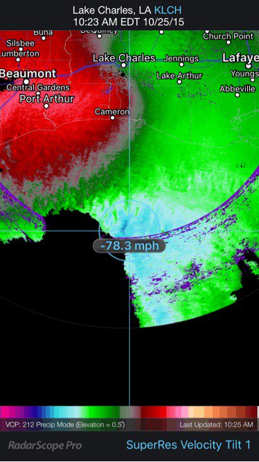
https://twitter.com/EricBlake12/status/ ... 9926528000
Eric Blake
@EricBlake12
Some elevated hurricane-force winds showing up well above the surface on the @NWSLakeCharles radar!
-
srainhoutx

- Site Admin

- Posts: 19616
- Joined: Tue Feb 02, 2010 2:32 pm
- Location: Maggie Valley, NC
- Contact:
Great Visible shot of the Coastal Low.
- Attachments
-
Carla/Alicia/Jerry(In The Eye)/Michelle/Charley/Ivan/Dennis/Katrina/Rita/Wilma/Humberto/Ike/Harvey
Member: National Weather Association
Facebook.com/Weather Infinity
Twitter @WeatherInfinity
Member: National Weather Association
Facebook.com/Weather Infinity
Twitter @WeatherInfinity
will next weekend bring us another round of storms
-
srainhoutx
- Site Admin
- Posts: 19616
- Joined: Tue Feb 02, 2010 2:32 pm
- Location: Maggie Valley, NC
- Contact:
ticka1 wrote:will next weekend bring us another round of storms
It is looking like it...
EXTENDED FORECAST DISCUSSION
NWS WEATHER PREDICTION CENTER COLLEGE PARK MD
1151 AM EDT SUN OCT 25 2015
VALID 12Z WED OCT 28 2015 - 12Z SUN NOV 01 2015
...MODELS SIGNALING MORE HEAVY RAINFALL FOR TEXAS THIS COMING
WEEKEND...
USED THE 00Z ECMWF AS A SYNOPTIC GUIDE THIS FORECAST. THE ECMWF
WAS WELL CORRELATED WITH THE ENSEMBLE MEANS FROM BOTH THE 00Z AND
06Z MODEL CYCLES, AND DID NOT FEATURE SOME OF THE MORE DUBIOUS
ASPECTS OF THE RECENT GFS RUNS LIKE THE WHOLESALE RECIRCULATION OF
HURRICANE OLAF DOWN THE CALIFORNIA COAST. THE FLOW ACROSS CENTRAL
NORTH AMERICA WILL BE MARKED BY VOLATILE EDDIES, WITH THE
MERIDIONAL INDEX STILL HIGH. ONE OF THE REGIONS THAT IS LIKELY TO
GET STUCK IN A REPETITIVE REGIME WILL BE THE SOUTH CENTRAL STATES,
SPECIFICALLY TEXAS. A NEW TROUGH SETTLING INTO MEXICO WILL RETAP
THE TROPICS FOR MOISTURE, WITH SEVERAL INCHES OF NEW RAINFALL
INDICATED BY MANY OF THE OPERATIONAL MODELS.
CISCO

Carla/Alicia/Jerry(In The Eye)/Michelle/Charley/Ivan/Dennis/Katrina/Rita/Wilma/Humberto/Ike/Harvey
Member: National Weather Association
Facebook.com/Weather Infinity
Twitter @WeatherInfinity
Member: National Weather Association
Facebook.com/Weather Infinity
Twitter @WeatherInfinity
-
srainhoutx
- Site Admin
- Posts: 19616
- Joined: Tue Feb 02, 2010 2:32 pm
- Location: Maggie Valley, NC
- Contact:
Winds above the deck around 2000 feet are running at 50kts out of the North. Expect gusty winds at the surface the next several hours until the Low pulls away. Along the Coast, Gale Force winds are likely.
Carla/Alicia/Jerry(In The Eye)/Michelle/Charley/Ivan/Dennis/Katrina/Rita/Wilma/Humberto/Ike/Harvey
Member: National Weather Association
Facebook.com/Weather Infinity
Twitter @WeatherInfinity
Member: National Weather Association
Facebook.com/Weather Infinity
Twitter @WeatherInfinity
It sure is windy out there! Some pretty strong gust coming through periodically.
-
Katdaddy

- Global Moderator

- Posts: 2502
- Joined: Thu Feb 04, 2010 8:18 am
- Location: League City, Tx
- Contact:
...WIND ADVISORY IN EFFECT UNTIL 7 AM CDT MONDAY...
THE NATIONAL WEATHER SERVICE IN HOUSTON/GALVESTON HAS ISSUED A
WIND ADVISORY...WHICH IS IN EFFECT UNTIL 7 AM CDT MONDAY.
* EVENT...NORTH WINDS AT 20 TO 30 MPH WITH STRONGER GUSTS CLOSE
TO 40 MPH.
* TIMING...ALL DAY TODAY. WINDS SHOULD DECREASE THIS EVENING AND
OVERNIGHT.
* IMPACT...EXPECT GUSTY WINDS CAPABLE OF MOVING AROUND ITEMS NOT
ANCHORED TO THE GROUND. DRIVERS SHOULD USE CAUTION...
ESPECIALLY WHEN DRIVING ALONG EAST TO WEST ORIENTED ROADS.
PRECAUTIONARY/PREPAREDNESS ACTIONS...
DRIVERS OF VANS...CAMPERS...TRAILERS...AND OTHER HIGH-PROFILE
VEHICLES SHOULD BE ALERT TO THE DANGER OF STRONG CROSS WINDS...
ESPECIALLY WHEN DRIVING ALONG EAST TO WEST ORIENTED ROADS.

Patricia's ghost demanded respect when moving up the coast.
Gusty in CLL. We've tallied 10.35 in IMBY over the duration of the event. Limited flash flooding locally.
Gusty in CLL. We've tallied 10.35 in IMBY over the duration of the event. Limited flash flooding locally.
-
srainhoutx
- Site Admin
- Posts: 19616
- Joined: Tue Feb 02, 2010 2:32 pm
- Location: Maggie Valley, NC
- Contact:
The 12Z Global guidance continue to advertise a wet and stormy Halloween across Texas.
- Attachments
-
-
Carla/Alicia/Jerry(In The Eye)/Michelle/Charley/Ivan/Dennis/Katrina/Rita/Wilma/Humberto/Ike/Harvey
Member: National Weather Association
Facebook.com/Weather Infinity
Twitter @WeatherInfinity
Member: National Weather Association
Facebook.com/Weather Infinity
Twitter @WeatherInfinity
Smith Point @2:54
2.35" of rain
Wind gust to 43mph due north
Texans loosing big time
2.35" of rain
Wind gust to 43mph due north
Texans loosing big time

For our friends in Hardin County........
BULLETIN - EAS ACTIVATION REQUESTED
FLASH FLOOD WARNING
NATIONAL WEATHER SERVICE LAKE CHARLES LA
334 PM CDT SUN OCT 25 2015
THE NATIONAL WEATHER SERVICE IN LAKE CHARLES HAS ISSUED A
* FLASH FLOOD WARNING FOR...
HARDIN COUNTY IN SOUTHEASTERN TEXAS...
* UNTIL 630 PM CDT
* AT 331 PM CDT...DOPPLER RADAR AND AUTOMATED STREAM GAUGES
INDICATED HEAVY RAIN FALLING ACROSS THE WARNED AREA HAS ALLOWED
WATER TO RISE ALONG BLACK CREEK NORTH OF SOUR LAKE AND PINE ISLAND
BAYOU NEAR BATSON. TWO TO THREE INCHES OF RAIN HAVE ALREADY FALLEN
WITH A 24 HOUR TOTAL OF NEAR 6 INCHES. FLASH FLOODING IS EXPECTED
TO BEGIN SHORTLY.
* SOME LOCATIONS THAT WILL EXPERIENCE FLOODING INCLUDE...
BEAUMONT...LUMBERTON...SILSBEE...KOUNTZE...SOUR LAKE...SARATOGA...
BATSON...CANEY HEAD AND HONEY ISLAND.
~~~When Thunder Roars Go Indoors~~~
~~~Turn Around Don't Drown~~~
~~~Run From The Water, Hide From The Wind~~~
~~~Turn Around Don't Drown~~~
~~~Run From The Water, Hide From The Wind~~~
Also of note to how strong this Low/Patricia is..... Storm Warnings hoisted by NWS LCH
URGENT - MARINE WEATHER MESSAGE
NATIONAL WEATHER SERVICE LAKE CHARLES LA
1234 PM CDT SUN OCT 25 2015
...STORM WARNING IN EFFECT FOR INTERCOASTAL CITY TO HIGH
ISLAND WITH A GALE WARNING FOR LOWER ATCHAFALAYA RIVER TO
INTRACOASTAL CITY THROUGH 10 PM...
.A LOW PRESSURE OFF THE SOUTHEAST TEXAS COAST IS EXPECTED TO MOVE
NORTHEAST TODAY. THIS IS BRINGING BUILDING SEAS AND INCREASING
WINDS...WITH FREQUENT GUSTS ABOVE GALE FORCE OVER THE GULF
WATERS... THESE CONDITIONS WILL PERSIST THROUGH TODAY.
GMZ450-452-470-472-260145-
/O.UPG.KLCH.GL.W.0005.000000T0000Z-151026T1200Z/
/O.NEW.KLCH.SR.W.0001.151025T1734Z-151026T0300Z/
/O.NEW.KLCH.GL.W.0006.151026T0300Z-151026T1200Z/
COASTAL WATERS FROM CAMERON LA TO HIGH ISLAND TX OUT 20 NM-
COASTAL WATERS FROM INTRACOASTAL CITY TO CAMERON LA OUT 20 NM-
WATERS FROM CAMERON LA TO HIGH ISLAND TX FROM 20 TO 60 NM-
WATERS FROM INTRACOASTAL CITY TO CAMERON LA FROM 20 TO 60 NM-
1234 PM CDT SUN OCT 25 2015
...STORM WARNING IN EFFECT UNTIL 10 PM CDT THIS EVENING...
...GALE WARNING IN EFFECT FROM 10 PM THIS EVENING TO 7 AM CDT
MONDAY...
THE NATIONAL WEATHER SERVICE IN LAKE CHARLES HAS ISSUED A STORM
WARNING...WHICH IS IN EFFECT UNTIL 10 PM CDT THIS EVENING. A GALE
WARNING HAS ALSO BEEN ISSUED. THIS GALE WARNING IS IN EFFECT
FROM 10 PM THIS EVENING TO 7 AM CDT MONDAY. THE GALE WARNING IS
NO LONGER IN EFFECT.
* WINDS...45 TO 50 KNOTS NEARSHORE...45 TO 50 KNOTS BEYOND 20 NM.
FREQUENT GUSTS HIGHER.
* WAVES/SEAS...SEAS 8 TO 12 FEET SUNDAY IN THE COASTAL WATERS
BEYOND 20 NAUTICAL MILES. SEAS OF 6 TO 9 FEET ARE EXPECTED IN
THE NEAR SHORE WATERS.
PRECAUTIONARY/PREPAREDNESS ACTIONS...
A STORM WARNING MEANS WINDS OF 48 TO 63 KNOTS ARE IMMINENT OR
OCCURRING. RECREATIONAL BOATERS SHOULD REMAIN IN PORT...OR TAKE
SHELTER UNTIL WINDS AND WAVES SUBSIDE. COMMERCIAL VESSELS SHOULD
PREPARE FOR VERY STRONG WINDS AND DANGEROUS SEA CONDITIONS...AND
CONSIDER REMAINING IN PORT OR TAKING SHELTER IN PORT UNTIL WINDS
AND WAVES SUBSIDE.
A GALE WARNING MEANS WINDS OF 34 TO 47 KNOTS ARE IMMINENT OR
AUGURING. OPERATING A VESSEL IN GALE CONDITIONS REQUIRES
EXPERIENCE AND PROPERLY EQUIPPED VESSELS. IT IS HIGHLY
RECOMMENDED THAT MARINERS WITHOUT THE PROPER EXPERIENCE SEEK SAFE
HARBOR PRIOR TO THE ONSET OF GALE CONDITIONS.
~~~When Thunder Roars Go Indoors~~~
~~~Turn Around Don't Drown~~~
~~~Run From The Water, Hide From The Wind~~~
~~~Turn Around Don't Drown~~~
~~~Run From The Water, Hide From The Wind~~~
-
srainhoutx
- Site Admin
- Posts: 19616
- Joined: Tue Feb 02, 2010 2:32 pm
- Location: Maggie Valley, NC
- Contact:
Afternoon briefing from Jeff:
Impressive coast storm heading for the Louisiana coast…very strong winds continue to lash the coastal areas.
Galveston has been gusting over 40mph since mid morning with a peak gust around 56mph early this afternoon. Very strong NW winds are resulting in storm surge flooding on the north (backside) areas of Galveston Island and Bolivar due to the strong winds attempting to push the built up high tides out of Galveston Bay. Galveston has been reporting flooding along the west end of the Island and also along the north side of the Island.
Should finally start to see things improve later this afternoon into the evening as the strong surface low moves eastward and the gradient weakens over SE TX. Still expecting a few more hours of 30-45mph winds along the coast and 20-30mph winds inland.
Light to at times moderate rainfall continues over a large portion of SE TX within the “wrap around shield” of the surface and upper level low. This rainfall should gradually end this evening, but clouds will continue overnight into Monday. Additional rainfall is not expected to cause additional flooding problems.
Hydro:
Excessive rainfall over the last 48 hours has led to rises on area watersheds, but dry grounds going into the event have certainly helped mitigate widespread flooding.
The only two major river systems experiencing flooding are the Tres Palacios River and the San Bernard River. The 15-20 inches of rainfall over N TX south of Dallas will generate a flood wave on the Trinity River and that will reach into Lake Livingston starting late this week.
River levels and forecasts can be viewed at:
http://www.srh.noaa.gov/wgrfc/
A few selected rainfall amounts:
2 W Downtown Houston: 10.36
Huffman: 10.28
Crosby: 10.16
Downtown Houston: 10.12
West University Place: 9.20
Pasadena: 8.32
16E Palacios: 10.10
Caldwell: 9.22
Jones Creek: 7.72
Fulshear: 7.87
Jersey Village: 7.24
Pearland: 7.36
Missouri City: 6.97
Katy: 5.78
Jamaica Beach: 6.16
Reliant Park: 7.40
Markham: 8.79
Seabrook: 5.28
Lake Houston Dam: 8.32
Aldine: 8.20
Greenspoint: 7.12
Kingwood: 7.44
End of Next Week:
Forecast models suggest another strong upper level storm system may approach the region Friday-next weekend with some potential for another extended period of heavy rainfall potential. Will be watching this as the week unfolds. Overall pattern favors another significant rainfall event setup.
Carla/Alicia/Jerry(In The Eye)/Michelle/Charley/Ivan/Dennis/Katrina/Rita/Wilma/Humberto/Ike/Harvey
Member: National Weather Association
Facebook.com/Weather Infinity
Twitter @WeatherInfinity
Member: National Weather Association
Facebook.com/Weather Infinity
Twitter @WeatherInfinity
-
wxman57

- Global Moderator
- Posts: 2621
- Joined: Thu Feb 04, 2010 5:34 am
- Location: Southwest Houston (Westbury)
- Contact:
8.9" for me in Westbury. That makes 64.1" for 2015. Next weekend may be quite rainy, too. At least Friday looks OK for the "Scream on the Green" at Discovery Green. We'll bike down there in costume with our bikes lighted up with LEDs.
-
BlueJay
- Posts: 938
- Joined: Tue Mar 04, 2014 10:47 am
- Location: Alden Bridge-The Woodlands, Texas
- Contact:
4.70 inches of rain for us!!
We should all be Singing in the Rain!!!!
Cue the music and watch Gene Kelly dance
https://www.youtube.com/watch?v=D1ZYhVpdXbQ
We should all be Singing in the Rain!!!!
Cue the music and watch Gene Kelly dance
https://www.youtube.com/watch?v=D1ZYhVpdXbQ