

October 2015 - Severe Storms/Moderate Risk Excessive Rainfal
-
srainhoutx

- Site Admin

- Posts: 19700
- Joined: Tue Feb 02, 2010 2:32 pm
- Location: Maggie Valley, NC
- Contact:
TS Patricia appears to be rapidly intensifying. NOAA RECON is currently investigating and are finding pressure falls are increasing fairly quickly and winds are certainly stronger than the last advisory.
Carla/Alicia/Jerry(In The Eye)/Michelle/Charley/Ivan/Dennis/Katrina/Rita/Wilma/Humberto/Ike/Harvey
Member: National Weather Association
Facebook.com/Weather Infinity
Twitter @WeatherInfinity
Member: National Weather Association
Facebook.com/Weather Infinity
Twitter @WeatherInfinity
-
srainhoutx
- Site Admin
- Posts: 19700
- Joined: Tue Feb 02, 2010 2:32 pm
- Location: Maggie Valley, NC
- Contact:
Lengthy Afternoon briefing from Jeff:
Extended period of unsettled weather heading for Texas.
Interesting feature has developed over the western Gulf of Mexico this afternoon with numerous thunderstorms. While models suggest a surge of deeper moisture, visible satellite images indicate a weakly defined rotation to the cloud pattern suggesting possibly a mid level disturbance that may have ejected out of the Bay of Campeche. Numerous thunderstorms accompany this feature as it is approaching the TX coast from the SE. Meso scale models are not really picking up on this feature…maybe the 4km WRF-NMM, but the TX Tech model does not see it. WRF-NMM really hammers our SW counties late tonight and much of the day tomorrow with excessive rainfall and extrapolation of the “vort” over the western Gulf would fall in line with that thinking while much of the rest of the guidance keeps things more on the scattered side. Will need to keep an eye on radar trends as this feature moves toward the coast.
Upper level storm system over the SW US will combine with TS Patricia off the west Mexico coast to produce a prolonged rainfall event over much of Texas from Thursday into Tuesday of next week.
Friday:
Upper level dynamics will move into western and central TX while rich tropical moisture from the Bay of Campeche lifts northward into TX. A batch of dry air over the SE US may move into SE TX on Friday keeping the highest rain chances aimed at the coastal bend into central and north TX. Friday will also feature the landfall of Hurricane Patricia on the west coast of Mexico and its associated moisture starting to lift northward over central Mexico
Weekend:
Upper trough edges closer to TX while mid and high level moisture and upper level vort from Patricia lifts NNE into TX. Expect numerous thunderstorms to develop from Saturday afternoon through Sunday night with potential for periods of sustained cell training in south to north bands. PWS surge to 2.3-2.5 inches (+2 SD above normal for late Oct). Lift will be sustained from the upper level trough and Patricia “vort” along with developing coastal trough. Weak frontal boundary comes into play on Sunday and only helps to enhance the heavy rainfall threat. As it that is not enough…models are attempting to develop a coastal low either on the weak front or as a surface reflection of the upper level remains of Patricia (this would be similar to a decaying Gulf of Mexico hurricane forming a surface reflection days later off the US east coast). The GFS and ECWMF models want to then linger this system off the TX coast into the middle of next week which would only keep rain chances going longer into next week.
Rainfall Amounts:
Models continue to advertise heavy totals of anywhere from 5-15 inches over the next 5-days over portions of the state. Two main areas are starting to indicate enhanced potential.
1) N TX into SE OK
2) TX coastal bend into SC TX and the SW/W portions of SE TX
While these two areas appear the current primed target for the maximum rainfall…these areas have been shifting around some and the overall pattern will support excessive rainfall over a large portion of TX so I would not put much confidence in the exact areas of heavy rainfall at this time.
One interesting aspect that does continue to show up in many of the models is a wedge of dry air that seems to not want to dislodge over EC TX into portions of SE TX and this continues to cut back rainfall amounts from Houston northeastward. This appears to be a function of the alignment of the surface high and recirculation of dry air over the SE US based on 850mb wind trajectories. Such trajectories show the air mass flowing into the coastal bend originating in the Caribbean Sea while that flow into areas east of I-45 are originating in a much drier air mass off the SC coast. At some point the moisture from Patricia will likely overcome this dry air surge…but this could lead to vast rainfall total differences over SE TX.
Will go with widespread 3-5 inches west of I-45 and 2-4 inches E of I-45. Isolated locations could easily see 10 inches especially the Matagorda Bay region up toward College Station.
While grounds are very dry, widespread significant rainfall is certainly going to produce run-off at some point. Flash Flood guidance is around 5-6 inches for all of our counties, but gradual saturation of the soil layer is expected over time. Wildcard may end up being just where and how much rain falls tomorrow from the “vort” approaching the TX coast this afternoon as this could lead to early ground saturation and much more significant run-off during the weekend period.
Tides:
Continue to have issues at high tide on Bolivar with overwash of HWY 87 just west of HWY 124. Tides continue to run 1-2 ft above normal and see no reason that is going to change into the weekend with sustained 15-25mph onshore winds. Tides on the west side of Galveston and Matagorda Bays have been averaging around 3.0 ft total water level which is about 1-1.5 ft below coastal flood warning criteria. Do not think we will reach warning criteria over the next several days…but a coastal flood advisory will remain in effect since some minor overwash is already occurring with current levels.
Tides Sunday into Monday will depend on what if anything transpires off the coast with respect to any sort of non-tropical surface low formation. Such a feature if it were to develop would certainly increase winds and seas and given already higher than normal tides, if would not take much to push water levels above critical flood thresholds.
Summary of Changes:
· Potential for heavy rains tonight/Thursday around Matagorda Bay and southwest counties
· Delayed onset of heavy rainfall event from Friday to Saturday over SE TX with arrival of remains of TC Patricia
· Extend duration of the event into Monday, possibly Tuesday
Highlights:
· Heaviest rainfall likely west of I-45
· Some flooding will be possible over the weekend especially Sunday
· Rises on area rivers possible early next week
· Coastal tides will remain 1-2 ft above normal with some overwash on Bolivar at high tide
Carla/Alicia/Jerry(In The Eye)/Michelle/Charley/Ivan/Dennis/Katrina/Rita/Wilma/Humberto/Ike/Harvey
Member: National Weather Association
Facebook.com/Weather Infinity
Twitter @WeatherInfinity
Member: National Weather Association
Facebook.com/Weather Infinity
Twitter @WeatherInfinity
-
mckinne63
- Posts: 553
- Joined: Fri Jul 08, 2011 4:50 pm
- Location: Stafford, TX
- Contact:
Hubby and I are headed to Hammond, LA tomorrow and will be coming back Sunday. Do you think the weather is going to be bad on Sunday? And...is the rain going to extend that far to the East? From what I saw earlier this week, probably not, but I am not a weather expert. We are moving my mil into a new house, am hoping for good weather for the move, but am also worried about the weather trying to get back home on Sunday.
-
Katdaddy

- Global Moderator

- Posts: 2521
- Joined: Thu Feb 04, 2010 8:18 am
- Location: League City, Tx
- Contact:
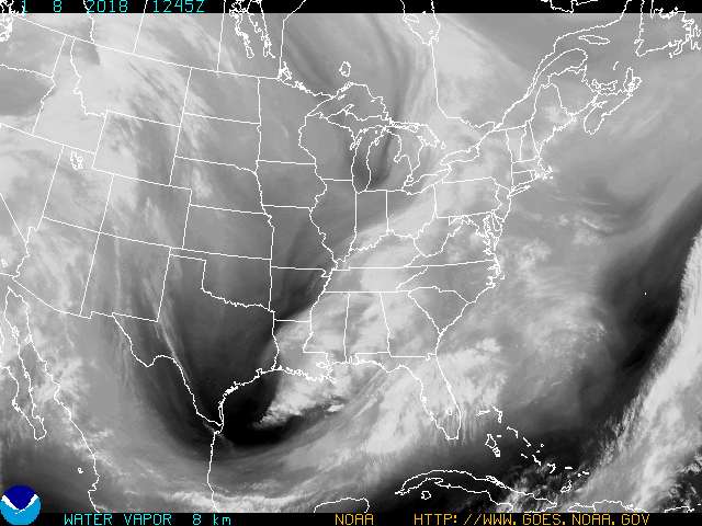
A nice VIS satellite image of a large portion of TX and the NW GOM. Quite an area of showers and thunderstorms headed toward the TX Coast this evening.
- Attachments
-
-
DoctorMu

- Posts: 8031
- Joined: Sun Jun 28, 2015 11:58 am
- Location: College Station
- Contact:
Cool pic. The East Conus Vapor Loop is picking up the SJT, trough and MLL nicely. Once moisture and SWs get into the firehose, watch out!Katdaddy wrote:A nice VIS satellite image of a large portion of TX and the NW GOM. Quite an area of showers and thunderstorms headed toward the TX Coast this evening.
http://www.goes.noaa.gov/GSSLOOPS/ecwv.html

-
srainhoutx
- Site Admin
- Posts: 19700
- Joined: Tue Feb 02, 2010 2:32 pm
- Location: Maggie Valley, NC
- Contact:
Tropical Storm Patricia continues to organize rapidly. The track guidance seem steady, but the intensity guidance is creeping up. Patricia will play a major role in our heavy rainfall event across the Region.
- Attachments
-
-
-
Carla/Alicia/Jerry(In The Eye)/Michelle/Charley/Ivan/Dennis/Katrina/Rita/Wilma/Humberto/Ike/Harvey
Member: National Weather Association
Facebook.com/Weather Infinity
Twitter @WeatherInfinity
Member: National Weather Association
Facebook.com/Weather Infinity
Twitter @WeatherInfinity
-
Ptarmigan

- Statistical Specialist

- Posts: 4521
- Joined: Wed Feb 03, 2010 7:20 pm
- Contact:
When I see a circular looking tropical storm or hurricane, I can tell it is undergoing rapid intensification. I suspect it could be a Category 4 hurricane before landfall.srainhoutx wrote:Tropical Storm Patricia continues to organize rapidly. The track guidance seem steady, but the intensity guidance is creeping up. Patricia will play a major role in our heavy rainfall event across the Region.
-
Paul Robison
Ptarmigan wrote:When I see a circular looking tropical storm or hurricane, I can tell it is undergoing rapid intensification. I suspect it could be a Category 4 hurricane before landfall.srainhoutx wrote:Tropical Storm Patricia continues to organize rapidly. The track guidance seem steady, but the intensity guidance is creeping up. Patricia will play a major role in our heavy rainfall event across the Region.
Remember this, Ptarmigan?
From AccuWeather:
The extended Memorial Day Weekend ended on a wet note across eastern Texas when heavy rains and severe thunderstorms moved in late on Monday and into Tuesday morning.
As residents woke up on Tuesday, the rain and thunderstorms were diminishing across Texas but left behind swollen rivers, flooded roadways and a nightmare for those traveling in the area.
The Houston area was heavily hit and major flooding occurred throughout the city.
Six flood-related fatalities have been confirmed, according to the Houston Mayor's office. One person was still missing as of Wednesday evening.
A seventh person was found dead in Fort Bend County, near Houston, the county sheriff's office told The Associated Press.
Up to 21 people have died due to the persistent flooding across Oklahoma and Texas, AP reports.
Some locations on the western side of the city picking up more than 10 inches of rain from the storms. Houston averages 5.09 inches of rain for the entire month of May.
"Strong storms moved in and stalled over the Houston Metro, leading to an incredibly prolonged period of heavy rainfall," said AccuWeather Meteorologist Becky Elliott.
As residents in the Houston area woke up Tuesday morning, water levels rose higher than some cars at times.
Elliott continued by adding that the Houston Intercontinental Airport was continuously reporting thunderstorm activity for over seven hours straight.
Due to the flash flooding, authorities responded to more than 500 water-related rescues across the region as of Tuesday afternoon. Authorities said most were for people in cars who attempted to drive through high water.
On Monday evening, a dam ruptured in Bastrop County, Texas, located east of Austin. This sent a wall of water racing downstream, flooding roads and property in its path.
In less than three hours, all of the water being held back by the dam had emptied downstream.
Will it be worse than what happened then?
-
DoctorMu
- Posts: 8031
- Joined: Sun Jun 28, 2015 11:58 am
- Location: College Station
- Contact:
Hope your arks are ready. 

-
Andrew
- Site Admin
- Posts: 3508
- Joined: Wed Feb 03, 2010 9:46 pm
- Location: North-West Houston
- Contact:
00z GFS suggests plenty of rain across the state with parts of northern central Texas seeing 10+ inches. SE Texas would also be impacted more as the coastal trough/remnants of Patricia slowly move just off the coast.
For Your Infinite Source For All Things Weather Visit Our Facebook
-
srainhoutx
- Site Admin
- Posts: 19700
- Joined: Tue Feb 02, 2010 2:32 pm
- Location: Maggie Valley, NC
- Contact:
Hurricane Patricia continues to rapidly intensify and is looking likely to become a Major Hurricane before making landfall along the West Coast of Mexico late Friday with its remnants tracking across the Coastal Plains of Texas Sunday and Monday.
A line of strong storms is slowly marching S and E across portions of Western Oklahoma and N Central Texas this morning. Flash Flood Watches will be hoisted this afternoon across most of S Central/SE Texas where Watches haven't been issued already. The Weather Prediction Center has issued both a Moderate and Slight Risk for Excessive Rainfall across portions of South Central, NE and portions of Texas for Day 2 and 3. Heavy training rainfall is expected to begin Friday afternoon and extend into at least Sunday/Monday.
A line of strong storms is slowly marching S and E across portions of Western Oklahoma and N Central Texas this morning. Flash Flood Watches will be hoisted this afternoon across most of S Central/SE Texas where Watches haven't been issued already. The Weather Prediction Center has issued both a Moderate and Slight Risk for Excessive Rainfall across portions of South Central, NE and portions of Texas for Day 2 and 3. Heavy training rainfall is expected to begin Friday afternoon and extend into at least Sunday/Monday.
- Attachments
-
-
-
Carla/Alicia/Jerry(In The Eye)/Michelle/Charley/Ivan/Dennis/Katrina/Rita/Wilma/Humberto/Ike/Harvey
Member: National Weather Association
Facebook.com/Weather Infinity
Twitter @WeatherInfinity
Member: National Weather Association
Facebook.com/Weather Infinity
Twitter @WeatherInfinity
-
srainhoutx
- Site Admin
- Posts: 19700
- Joined: Tue Feb 02, 2010 2:32 pm
- Location: Maggie Valley, NC
- Contact:
Saturday night into early Monday could be very stormy across SE Texas.
- Attachments
-
Carla/Alicia/Jerry(In The Eye)/Michelle/Charley/Ivan/Dennis/Katrina/Rita/Wilma/Humberto/Ike/Harvey
Member: National Weather Association
Facebook.com/Weather Infinity
Twitter @WeatherInfinity
Member: National Weather Association
Facebook.com/Weather Infinity
Twitter @WeatherInfinity
-
unome
- Posts: 3062
- Joined: Fri Feb 12, 2010 6:11 pm
keep an eye on road conditions if you're traveling across the state(s) http://drivetexas.org
7-day loop of pressures & fronts: http://www.wpc.ncep.noaa.gov/basicwx/day0-7loop.html
WPC's short-range forecast, thru 12Z Sat at the moment, but should auto-update, and accompanying discussion: http://www.wpc.ncep.noaa.gov/discussion ... isc=pmdspd

7-day loop of pressures & fronts: http://www.wpc.ncep.noaa.gov/basicwx/day0-7loop.html
WPC's short-range forecast, thru 12Z Sat at the moment, but should auto-update, and accompanying discussion: http://www.wpc.ncep.noaa.gov/discussion ... isc=pmdspd
-
jasons2k

- Posts: 6193
- Joined: Thu Feb 04, 2010 12:54 pm
- Location: Imperial Oaks
- Contact:
-
srainhoutx
- Site Admin
- Posts: 19700
- Joined: Tue Feb 02, 2010 2:32 pm
- Location: Maggie Valley, NC
- Contact:
NWS WEATHER PREDICTION CENTER COLLEGE PARK MD
757 AM EDT THU OCT 22 2015
AREAS AFFECTED...WEST TEXAS
CONCERNING...HEAVY RAINFALL...FLASH FLOODING LIKELY
VALID 221156Z - 221556Z
SUMMARY...SLOW MOVING/BACKBUILDING CONVECTION IS EXPECTED TO
CONTINUE ALONG THE SOUTHERN EXTENT OF THE EXISTING LINE. LOCAL
RAIN RATES OF 1-2 INCHES/HR MAY PRODUCE ADDITIONAL FLASH FLOODING.
DISCUSSION...WHILE WIDESPREAD CONVECTION IS EXPECTED TO CONTINUE
ACROSS A LARGE EXTENT OF WEST TX INTO WESTERN AND CENTRAL
OK...BELIEVE THE GREATEST POTENTIAL FOR SLOW MOVING/BACKBUILDING
CONVECTION LIES ACROSS PORTIONS OF THE SOUTHEASTERN PANHANDLE
PLAINS OF TX...BACK INTO THE WESTERN HILL COUNTRY AND THE EASTERN
BIG BEND COUNTRY. STRONG SOUTHEASTERLY LOW LEVEL FLOW IS FORECAST
TO CONTINUE TO ADVECT HIGHER PW AND UNSTABLE AIR INTO A
SLOW-MOVING SURFACE BOUNDARY ESTABLISHED BY THE ONGOING
CONVECTION. COINCIDENT WITH THE LOW LEVEL INFLOW...LATEST
MESOANALYSIS SHOWS AN AXIS OF 1.5-2 INCH PWS AND 1000+ J/KG CAPE
ALONG THE RIO GRANDE VLY FROM THE LOWER TX COAST TOWARD THE
SOUTHERN EXTENT OF THE BOUNDARY. GUIDANCE SHOWS THIS LOW LEVEL
INFLOW PERSISTING INTO THE LATE MORNING HOURS WITH THE BOUNDARY
REMAINING QUASI-STATIONARY. MEANWHILE...STRONG UPPER DIVERGENCE
AFFORDED BY THE RIGHT-ENTRANCE REGION OF A SOUTHWEST-NORTHEAST
ORIENTED UPPER JET STREAK EXTENDING ACROSS THE TX PANHANDLE IS
EXPECTED TO PROVIDE LARGER SCALE LIFT.
THE LATEST OUTLOOK AREA WAS BASED LARGELY ON AMOUNTS PRODUCED BY
THE HRW-NMMB -- WHICH OF THE HI-RES GUIDANCE...APPEARS TO THE HAVE
ONE THE BETTER HANDLES ON THE CURRENT CONDITIONS.
PEREIRA
ATTN...WFO...LUB...MAF...SJT...
Carla/Alicia/Jerry(In The Eye)/Michelle/Charley/Ivan/Dennis/Katrina/Rita/Wilma/Humberto/Ike/Harvey
Member: National Weather Association
Facebook.com/Weather Infinity
Twitter @WeatherInfinity
Member: National Weather Association
Facebook.com/Weather Infinity
Twitter @WeatherInfinity
-
unome
- Posts: 3062
- Joined: Fri Feb 12, 2010 6:11 pm
interesting little swirl between Cuba & Yucatan this morning, but I can't find mention of it in NHC's discussion http://www.nhc.noaa.gov/text/refresh/MI ... WDAT.shtml?

-
srainhoutx
- Site Admin
- Posts: 19700
- Joined: Tue Feb 02, 2010 2:32 pm
- Location: Maggie Valley, NC
- Contact:
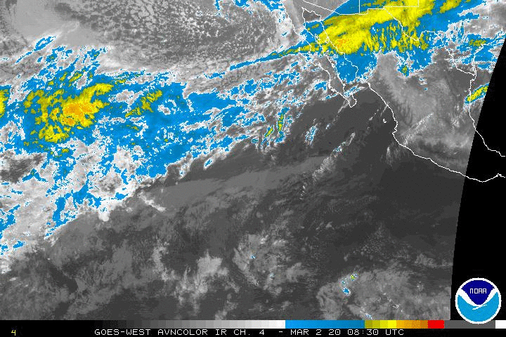
The NHC is monitoring another area of disturbed weather W of Patricia in the Eastern Pacific. The monsoonal trough is very active across the EPAC and it appears there are several more opportunities for tropical cyclone development with even another Major Hurricane making landfall along the West Coast of Mexico. The overnight Global models are suggesting a very active sub tropic jet pushing deep tropical moisture across Mexico and Texas through the end of October and into early November. There are additional indications that yet another Western trough will organize keeping our weather very El Nino like and unsettled with a couple of strong cold shots as well.

TROPICAL WEATHER OUTLOOK
NWS NATIONAL HURRICANE CENTER MIAMI FL
500 AM PDT THU OCT 22 2015
For the eastern North Pacific...east of 140 degrees west longitude:
The National Hurricane Center is issuing advisories on Hurricane
Patricia, located a couple of hundred miles south of Lazaro
Cardenas, Mexico.
1. An area of low pressure is expected to form several hundred miles
south or south-southwest of the southern tip of the Baja California
peninsula Friday or over the weekend. Environmental conditions are
expected to be marginally conducive for gradual development of this
system while it moves slowly toward the east-northeast or northeast.
* Formation chance through 48 hours...low...near 0 percent
* Formation chance through 5 days...low...20 percent
Forecaster Roberts
Carla/Alicia/Jerry(In The Eye)/Michelle/Charley/Ivan/Dennis/Katrina/Rita/Wilma/Humberto/Ike/Harvey
Member: National Weather Association
Facebook.com/Weather Infinity
Twitter @WeatherInfinity
Member: National Weather Association
Facebook.com/Weather Infinity
Twitter @WeatherInfinity
-
srainhoutx
- Site Admin
- Posts: 19700
- Joined: Tue Feb 02, 2010 2:32 pm
- Location: Maggie Valley, NC
- Contact:
From Nesdis:
SATELLITE PRECIPITATION ESTIMATES..DATE/TIME 10/22/15 1404Z
SATELLITE ANALYSIS BRANCH/NESDIS---NPPU---TEL.301-683-1404
LATEST DATA USED: GOES-EAST:1315Z JS
.
LOCATION...SW TO N CENT TEXAS...
.
ATTN WFOS...FWD...OUN...EWX...SJT...LUB...MAF...
ATTN RFCS...ABRFC...WGRFC...
.
EVENT...UPDATE TO PREVIOUS SPENES MESSAGES FOR SATELLITE
FEATURES/MESO-ANALYSIS FOR QLCS.
.
SATELLITE ANALYSIS AND TRENDS...SINCE LAST MESSAGE, SEEING THE BETTER
SATELLITE SIGNATURE AND SIGNALS FOR HEAVY RAINFALL (1"-2"/HR RATES NOTED
IN RECENT WPC MPD) SHIFTING TOWARD THE S PORTION OF THE QLCS FROM AROUND
UPTON TO STONEWALL/HASKELL COUNTIES WITH THE FAR S END SHOWING LITTLE
MOVEMENT WITH IT ALIGNED PARALLEL TO THE MEAN 850-300MB FLOW. ALSO
OF NOTE HAS BEEN VIRTUALLY NO EASTWARD PROGRESSION WITH THE PRIMARY
MID/UPPER CIRCULATION BACK OVER THE SW US WITH INDICATION OF A SPLIT IN
THE UPSTREAM FLOW OVER THE FAR W US. MORNING SOUNDING FROM DRT CERTAINLY
SUPPORTS WATER VAPOR IMAGERY IN DEPICTING SIGNIFICANT DRIER AIR ABOVE
500MB ALONG WITH VERY MOIST ENVIRONMENT BELOW 500MB. PRECIPITABLE WATER
VALUES OF 1.8" WERE PRESENT IN THE DRT SOUNDING WHICH ALONG WITH THE
MID 60'S TO NEAR 70F SFC DEWPOINTS IS INDICATIVE OF THE HIGHER MOISTURE
RESIDING FARTHER TO THE E AND SE OF THE QLCS. 13Z OBSERVATIONAL ANALYSIS
SHOWS SIGNIFICANT SFC BASED MOISTURE CONVERGENCE ALONG AND TO THE E AND
SE PERIPHERY OF THE LINE STRETCHING FROM NEAR DRYDEN-TERRELL (K6R6)
TX TO ALMOST HALFWAY BETWEEN MIDLAND AND SAN ANGELO. COLLOCATED WITH
THE HIGHER MOISTURE AND LOWER LEVEL CONVERGENCE IS A REGION OF HIGHER
INSTABILITY AS SEEN IN THE VARIOUS GOES SOUNDER INSTABILITY PRODUCTS
WITH SB CAPE VALUES GENERALLY RUNNING ROUGHLY FROM 1000-2000J/KG AND
LITTLE OR NO CINH. OBVIOUS STRONG UPPER LEVEL DIVERGENCE IS PRESENT WITH
THE WEDGE SHAPED SIGNATURE OF THE QLCS WHICH IS SUPPORTED IN THE RECENT
CIMSS/NOAA-NSSL WIND DIVERGENCE PRODUCT.
.
OUTLOOK...EXPECT THE CURRENT TRENDS TO CONTINUE WITH THE N PORTION OF
THE QLCS SHIFTING SLIGHTLY QUICKER TO THE E THAN THE FAR S END. HAVE
SEEN A SLIGHT REDUCTION IN THE OVERALL CLOUD TOP ENHANCEMENT SO RATES
MAY BE ON A BIT OF A DOWNWARD TURN AT THIS TIME WITH THE CORE OF THE BEST
ENHANCEMENT OVER W CENT-N CENT TX. ADDITIONALLY, HIGHER FFG VALUES EXIST
TO THE E OF THE CURRENT ACTIVITY SO THERE ARE SOME POTENTIAL MITIGATING
FACTORS FOR THE HEAVY RAIN THREAT OVER N CENT TX AT LEAST FOR NOW THOUGH
EVEN WITH THOSE TRENDS, THERE STILL WILL BE SOME TRAINING OF EMBEDDED
INTENSE CELLS. FARTHER S, THE LATEST SATELLITE TRENDS CONTINUE TO INDICATE
FAVORABLE SIGNS FOR MORE REGENERATION/BACK BUILDING ON THE FAR S FLANK.
STILL SEEING UP TO 40KTS OF SE LOW LEVEL INFLOW PER THE LATEST SAMPLING
OF REGIONAL 850MB VWP DATA WHICH ALONG WITH THE MOISTURE/INSTABILITY
RELATIVE MAX LOCATED TO THE E AND SE OF THE LINE SHOULD KEEP CONDITIONS
FAVORABLE HERE FOR AT LEAST A FEW MORE HOURS.
- Attachments
-
Carla/Alicia/Jerry(In The Eye)/Michelle/Charley/Ivan/Dennis/Katrina/Rita/Wilma/Humberto/Ike/Harvey
Member: National Weather Association
Facebook.com/Weather Infinity
Twitter @WeatherInfinity
Member: National Weather Association
Facebook.com/Weather Infinity
Twitter @WeatherInfinity
-
srainhoutx
- Site Admin
- Posts: 19700
- Joined: Tue Feb 02, 2010 2:32 pm
- Location: Maggie Valley, NC
- Contact:
Hurricane Patricia is likely a Major Hurricane at this time. The latest intensity guidance suggest it may become a Category 4 Hurricane before making landfall along the West Coast of Mexico sometime on Friday.
- Attachments
-
- 10222015_1415_goes13_x_ir1km_20EPATRICIA_80kts-975mb-147N-1032W_97pc.jpg (47.95 KiB) Viewed 6266 times
-
-
Carla/Alicia/Jerry(In The Eye)/Michelle/Charley/Ivan/Dennis/Katrina/Rita/Wilma/Humberto/Ike/Harvey
Member: National Weather Association
Facebook.com/Weather Infinity
Twitter @WeatherInfinity
Member: National Weather Association
Facebook.com/Weather Infinity
Twitter @WeatherInfinity