
December 2014: New Year's Eve Wintry Mix Possible
-
Portastorm

- Posts: 800
- Joined: Wed Feb 03, 2010 3:04 pm
- Location: Southwest Austin/Oak Hill, TX
- Contact:
Well, I *thought* we were going to be alright here in the AUS metro area but I see that dewpoints continue falling and now approaching the mid 20s in many areas around here. Any wet-bulbing effect early on could bring those surface temps down very close to or just below freezing ... right?jeff wrote:Dewpoints are going to have to be lower than that for any wet bulb effect. sub cloud layer is very dry and the QPF does not start until after sunrise tomorrow. Still think Austin and San Antonio will be ok...they may hit 32, but it is very marginal and EWX states that the only reason they included the I-35 counties was mainly for the western portions of those counties where some cold air drainage is possible. DFW area may be a different story however.srainhoutx wrote:A quick look at observations across Central and E Texas into Western Louisiana show near or just below freezing temperatures at Georgetown near Austin. Temperatures in Lufkin are near 34-36 and in Jasper into the Piney Woods E Texas and Western Louisiana near Dequincy temperatures are near the 34-36F range. Dewpoints here in NW Harris County have dropped to 32 and the air temperature is 39F.
-
brooksgarner

- Global Moderator

- Posts: 226
- Joined: Tue Jun 04, 2013 3:06 pm
- Location: Houston, TX
- Contact:
Here's a pic from viewer Cheryl Letolle this morning from Lubbock. Looks like a good coating to an inch.
Morning FutureTrack run keep icy mix well west of Austin at its closest pass to Houston (happening at peak wet bulbing tonight around midnight.) Liquid rain for us thru and thru... (Amazing to me that our area has seemed to dodge the winter aspect of this system completely. I mean, really!) This is a frigid air mass. Its core -- and momentum -- has worked into west TX and the southwest (pulled partially by that low over Cali)... So, by the time it gets here, it'll have moderated.
Broadcast Met
http://BrooksGarner.com
http://twitter.com/BrooksWeather
http://BrooksGarner.com
http://twitter.com/BrooksWeather
- '17 Harvey
- '12 Sandy (P3 Orion)
- '91 Bob
- '85 Gloria
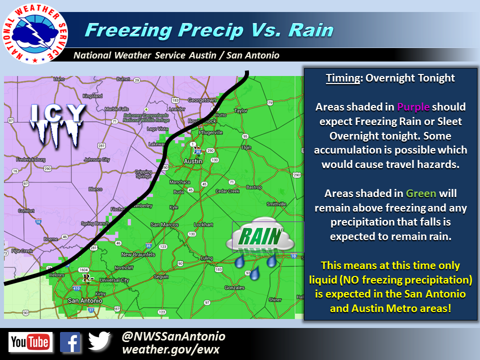
from NWS San Antonio/Austin's Twitter feed about 1 hr ago
https://twitter.com/NWSSanAntonio/statu ... 18/photo/1
10:51 am - Freezing Rain vs. Rain Coverage? The San Antonio/Austin Metro areas will just see rain!
https://twitter.com/NWSSanAntonio/statu ... 18/photo/1
10:51 am - Freezing Rain vs. Rain Coverage? The San Antonio/Austin Metro areas will just see rain!
-
srainhoutx

- Site Admin

- Posts: 19616
- Joined: Tue Feb 02, 2010 2:32 pm
- Location: Maggie Valley, NC
- Contact:
Accidents reported in Mountain Home (Kerr County) on HWY 41 and I-10 due to freezing drizzle.
Carla/Alicia/Jerry(In The Eye)/Michelle/Charley/Ivan/Dennis/Katrina/Rita/Wilma/Humberto/Ike/Harvey
Member: National Weather Association
Facebook.com/Weather Infinity
Twitter @WeatherInfinity
Member: National Weather Association
Facebook.com/Weather Infinity
Twitter @WeatherInfinity
-
srainhoutx
- Site Admin
- Posts: 19616
- Joined: Tue Feb 02, 2010 2:32 pm
- Location: Maggie Valley, NC
- Contact:
AREA FORECAST DISCUSSION
NATIONAL WEATHER SERVICE SAN ANGELO TX
1217 PM CST WED DEC 31 2014
.UPDATE...
Temperatures are reluctant to warm at all today, currently ranging
from the mid teens north of I-20 to the mid 20s along the I-10
corridor. Max temps were lowered a good 4-5 degrees today.
Precipitation type was modified as well. Carrying occasional
freezing drizzle with a chance for sleet. Otherwise, changes were
minor. We're still looking for precip to increase in coverage and
intensity tonight with additional ice accumulations up to 1/4 inch
possible from the Concho Valley into the Big Country.
Johnson
Carla/Alicia/Jerry(In The Eye)/Michelle/Charley/Ivan/Dennis/Katrina/Rita/Wilma/Humberto/Ike/Harvey
Member: National Weather Association
Facebook.com/Weather Infinity
Twitter @WeatherInfinity
Member: National Weather Association
Facebook.com/Weather Infinity
Twitter @WeatherInfinity
-
SaskatchewanScreamer
- Posts: 36
- Joined: Thu Jan 03, 2013 3:18 pm
- Contact:
I'M BAAAAAAAAAAAAAAACK! 
LOOKING FORWARD TO THE NEW YEAR'S BOYS!
LOLOLOLOLOLOLOLOL
LOOKING FORWARD TO THE NEW YEAR'S BOYS!
LOLOLOLOLOLOLOLOL
Last edited by SaskatchewanScreamer on Wed Dec 31, 2014 1:03 pm, edited 1 time in total.

There was some talk here over the last weekend about the trajectory of the cut-off cold core low, and the possibility of the column cooling off enough for snow directly under it's path. It appears that the low has indeed cutoff and is generally headed toward Texas, but I've seen no further discussions. Any thoughts?
-
SaskatchewanScreamer
- Posts: 36
- Joined: Thu Jan 03, 2013 3:18 pm
- Contact:
AND DAVID DO I EVER HAVE A BIIIIIIIIIIG SURPRISE FOR YOU!
PERMANENTLY BAN ME?
YOU KNOW NOT WHAT YOU HAVE DONE!
*EVIL GRIN*
PERMANENTLY BAN ME?
YOU KNOW NOT WHAT YOU HAVE DONE!
*EVIL GRIN*
-
srainhoutx
- Site Admin
- Posts: 19616
- Joined: Tue Feb 02, 2010 2:32 pm
- Location: Maggie Valley, NC
- Contact:
SaskatchewanScreamer wrote:AND DAVID DO I EVER HAVE A BIIIIIIIIIIG SURPRISE FOR YOU!
PERMANENTLY BAN ME?
YOU KNOW NOT WHAT YOU HAVE DONE!
*EVIL GRIN*
Welcome back Screamer. You sure opened the doors up in Canada sending all this mess S, didn't you?
Carla/Alicia/Jerry(In The Eye)/Michelle/Charley/Ivan/Dennis/Katrina/Rita/Wilma/Humberto/Ike/Harvey
Member: National Weather Association
Facebook.com/Weather Infinity
Twitter @WeatherInfinity
Member: National Weather Association
Facebook.com/Weather Infinity
Twitter @WeatherInfinity
-
brooksgarner
- Global Moderator
- Posts: 226
- Joined: Tue Jun 04, 2013 3:06 pm
- Location: Houston, TX
- Contact:
The cut-off upper-low will most likely take a track toward the panhandle before opening up... no chance at this time of a surprise snow since it has, indeed cut-off. All this has done is siphon-away the core of the arctic air away from Houston, giving us a NE wind (pulling in moderated arctic air) rather than the NW wind required for more pure arctic air. Columns remain too warm to support snow in SE TX by a large margin... (500mb chart shows core of upper low too far north... MSLP confirms 540 "rough snow line" stays in panhandle. I chose these two maps for Sunday morning, because this represents the farthest "south" the chilly column travels, before lifting out of the region.)Kludge wrote:There was some talk here over the last weekend about the trajectory of the cut-off cold core low, and the possibility of the column cooling off enough for snow directly under it's path. It appears that the low has indeed cutoff and is generally headed toward Texas, but I've seen no further discussions. Any thoughts?
Broadcast Met
http://BrooksGarner.com
http://twitter.com/BrooksWeather
http://BrooksGarner.com
http://twitter.com/BrooksWeather
- '17 Harvey
- '12 Sandy (P3 Orion)
- '91 Bob
- '85 Gloria
-
srainhoutx
- Site Admin
- Posts: 19616
- Joined: Tue Feb 02, 2010 2:32 pm
- Location: Maggie Valley, NC
- Contact:
MODEL DIAGNOSTIC DISCUSSION
NWS WEATHER PREDICTION CENTER COLLEGE PARK MD
145 PM EST WED DEC 31 2014
VALID DEC 31/1200 UTC THRU JAN 04/0000 UTC
...SEE NOUS42 KWNO (ADMNFD) FOR THE STATUS OF THE UPPER AIR
INGEST...
12Z MODEL EVALUATION ALONG WITH FINAL PREFERENCES
~~~~~~~~~~~~~~~~~~~~~~~~~~~~~~~~~~~~~~~~~~~~~~~~~~~~~~~~~~~~~~~~~~~
THERE DID NOT APPEAR TO BE ANY INITIALIZATION ERRORS WITH THE 12Z
NAM/GFS DEEMED SIGNIFICANT ENOUGH TO IMPACT THEIR FORECASTS.
ANOMALOUS CLOSED LOW INITIALLY OVER THE DESERT SOUTHWEST
~~~~~~~~~~~~~~~~~~~~~~~~~~~~~~~~~~~~~~~~~~~~~~~~~~~~~~~~~~~~~~~~~~~
PREFERENCE: BLEND OF THE 12Z GFS-PARALLEL/00Z ECMWF/12Z ECMWF
CONFIDENCE: BELOW AVERAGE
MODEL TRENDS OVER THE PAST FEW DAYS HAVE SHOWN TWO MAIN VORTICITY
MAXIMA TIED TO THE CLOSED LOW CURRENTLY OVER THE
SOUTHWEST...VERSUS HOLDING TOGETHER AS ONE ENTITY. ONE VORTICITY
MAX IS FORECAST TO EJECT OUT FROM THE CLOSED LOW INTO THE CNTRL
PLAINS THU NIGHT AND WEAKEN EWD INTO CONFLUENT MID-LEVEL FLOW.
THERE SHOULD BE A POTENT SPEED MAX TIED TO THIS FEATURE...BUT THE
12Z GFS IS MUCH WEAKER THAN THE CONSENSUS HERE. THE 00Z ECMWF IS
STRONGER/FASTER BUT NOW THE 12Z ECMWF IS CLOSE TO THE TIMING OF
THE 12Z NAM AND ENSEMBLE MEANS BUT NOT QUITE AS STRONG AS THE NAM.
BASICALLY...THE 12Z ECMWF SEEMS TO SHOW A GOOD COMPROMISE AMONG
THE LATEST MODELS WITH THE VORT MAX EJECTING EWD ACROSS THE PLAINS
AND MIDWEST...WHILE THE 00Z UKMET/CMC ARE SLOWER.
NEXT IS THE REMNANT CLOSED LOW ACROSS THE SOUTHWEST...IN WHICH THE
12Z UKMET IS MUCH SLOWER TO MOVE EAST THAN THE CURRENT MODEL
CONSENSUS...THOUGH QUICKER THAN THE 00Z UKMET...AND THE UKMET
REMAINS ON THE SLOW EDGE OF THE LATEST ENSEMBLE SPREAD. THE 12Z
ECMWF TRENDED SLIGHTLY SLOWER THAN ITS 00Z RUN AND 12Z GFS
PARALLEL...WITH THE 12Z GFS PARALLEL SLIGHTLY DEEPER THAN THE 12Z
GFS. A BLEND OF THE 12Z/00Z ECMWF APPEARS TO FORM A REASONABLE
COMPROMISE WITH THE UPPER LOW SLIDING EAST FROM THE SOUTHWESTERN
CONUS...ALONG WITH THE 12Z GFS PARALLEL. THE 12Z NAM...DOES NOT
APPEAR TO BE A BAD CHOICE EITHER...ALTHOUGH IT IS MORE AGGRESSIVE
IN THE LOWER LEVELS WITH RETURN FLOW INTO THE SOUTH. DUE TO THE
COMPLICATED INTERACTION OF MANY VARIABLES WITH THIS SYSTEM...AND
POORER THAN USUAL RUN TO RUN CONTINUITY...CONFIDENCE IS BELOW
AVERAGE.
Carla/Alicia/Jerry(In The Eye)/Michelle/Charley/Ivan/Dennis/Katrina/Rita/Wilma/Humberto/Ike/Harvey
Member: National Weather Association
Facebook.com/Weather Infinity
Twitter @WeatherInfinity
Member: National Weather Association
Facebook.com/Weather Infinity
Twitter @WeatherInfinity
-
SaskatchewanScreamer
- Posts: 36
- Joined: Thu Jan 03, 2013 3:18 pm
- Contact:
AH THANK YOU FOR THE LOVELY WELCOME SRAINHOUTX!srainhoutx wrote:SaskatchewanScreamer wrote:AND DAVID DO I EVER HAVE A BIIIIIIIIIIG SURPRISE FOR YOU!
PERMANENTLY BAN ME?
YOU KNOW NOT WHAT YOU HAVE DONE!
*EVIL GRIN*
Welcome back Screamer. You sure opened the doors up in Canada sending all this mess S, didn't you?
THAT I DID!
SO SOUTHERN METS IT IS TIME FOR YOU BOYS TO WAKE UP!
Feel the madness taking over
While you lie in frozen sleep
Though my life's now fading
You're still a promise I will keep
Wait in the dark
Every feeling becomes so magnified
And my mind
Goes on and on
I'm trying to hold on
But I keep losing control ......
https://www.youtube.com/watch?v=72oJGTPSWIM
P.S. NOW DON'T THINK YOU ARE THE ONLY ONES I SEEK REVENGE ON...SOUTHERN ONTARIO AND CYCLENALL ESP IS ALSO IN MY SIGHTS1
Last edited by SaskatchewanScreamer on Wed Dec 31, 2014 1:41 pm, edited 1 time in total.
-
srainhoutx
- Site Admin
- Posts: 19616
- Joined: Tue Feb 02, 2010 2:32 pm
- Location: Maggie Valley, NC
- Contact:
SHORT TERM FORECAST
NATIONAL WEATHER SERVICE SAN ANGELO TX
126 PM CST WED DEC 31 2014
TXZ049-054-064>066-071>073-076>078-098-099-113-114-127-128-139-
140-154-155-168>170-312330-
FISHER-NOLAN-STERLING-COKE-RUNNELS-IRION-TOM GREEN-CONCHO-
CROCKETT-SCHLEICHER-SUTTON-HASKELL-THROCKMORTON-JONES-SHACKELFORD-
TAYLOR-CALLAHAN-COLEMAN-BROWN-MCCULLOCH-SAN SABA-MENARD-KIMBLE-
MASON-
INCLUDING THE CITIES OF...ROTAN...ROBY...SWEETWATER...
STERLING CITY...ROBERT LEE...BRONTE...BALLINGER...WINTERS...
MERTZON...SAN ANGELO...EDEN...OZONA...ELDORADO...SONORA...
HASKELL...THROCKMORTON...WOODSON...STAMFORD...ANSON...HAMLIN...
ALBANY...ABILENE...CLYDE...BAIRD...CROSS PLAINS...COLEMAN...
BROWNWOOD...BRADY...SAN SABA...MENARD...JUNCTION...MASON
126 PM CST WED DEC 31 2014
.NOW...
...WINTER STORM WARNING IN EFFECT UNTIL NOON CST THURSDAY...
DRIVING CONDITIONS ARE VERY DANGEROUS RIGHT NOW...AND THESE
CONDITIONS WILL PERSIST THROUGH TOMORROW. MANY ACCIDENTS HAVE
ALREADY OCCURRED...WITH AREA ROADS IMPASSIBLE IN SOME AREAS. WE
ENCOURAGE EVERYONE TO STAY HOME IF AT ALL POSSIBLE. IF YOU MUST
VENTURE OUTSIDE...PLEASE USE EXTREME CAUTION AND TAKE YOUR TIME. A
LIGHT WINTRY MIX OF FREEZING DRIZZLE...FREEZING RAIN...OR SLEET
WILL CONTINUE TO DEVELOP THROUGH 6 PM ACROSS ALL OF WEST CENTRAL
TEXAS. CONDITIONS ARE EXPECTED TO CONTINUE TO DETERIORATE THIS
EVENING AND OVERNIGHT...WHEN THE FREEZING RAIN AND SLEET MAY
INCREASE IN COVERAGE AND INTENSITY...WITH A FEW THUNDERSTORMS ALSO
POSSIBLE.
$$
DOLL
Carla/Alicia/Jerry(In The Eye)/Michelle/Charley/Ivan/Dennis/Katrina/Rita/Wilma/Humberto/Ike/Harvey
Member: National Weather Association
Facebook.com/Weather Infinity
Twitter @WeatherInfinity
Member: National Weather Association
Facebook.com/Weather Infinity
Twitter @WeatherInfinity
-
Heat Miser

- Posts: 229
- Joined: Wed Nov 27, 2013 12:48 pm
- Location: FM 528 @ I45 border of League City, Webster, Friendswood
- Contact:
Seemed much colder with the less talked about front last weekend. This (arctic outbreak) is really just a cold front to me. Nothing to write home about, especially in the Houston area.

I think there is a general mis-understanding of what is meant by arctic front. It is the source region of the air mass behind the front. This event for SE TX has more modified arctic air with the true arctic air trapped across W TX. Many arctic fronts in SE TX result in exactly what is happening currently outside...temps. in the 40's and cloudy skies.Heat Miser wrote:Seemed much colder with the less talked about front last weekend. This (arctic outbreak) is really just a cold front to me. Nothing to write home about, especially in the Houston area.
-
SaskatchewanScreamer
- Posts: 36
- Joined: Thu Jan 03, 2013 3:18 pm
- Contact:
just wait....Houston's turn WILL COME.Heat Miser wrote:Seemed much colder with the less talked about front last weekend. This (arctic outbreak) is really just a cold front to me. Nothing to write home about, especially in the Houston area.
Surface wet bulb temp in Austin is currently 33-34 degrees with 39/29 being reporting at both major airports. Still not enough to get Austin to 32 and even 32 would probably be fine...really need 30-31 for roadway icing. Hill Country looks ground zero into western N TX for .10-.25 of an inch ice accumulation.Portastorm wrote:Well, I *thought* we were going to be alright here in the AUS metro area but I see that dewpoints continue falling and now approaching the mid 20s in many areas around here. Any wet-bulbing effect early on could bring those surface temps down very close to or just below freezing ... right?jeff wrote:Dewpoints are going to have to be lower than that for any wet bulb effect. sub cloud layer is very dry and the QPF does not start until after sunrise tomorrow. Still think Austin and San Antonio will be ok...they may hit 32, but it is very marginal and EWX states that the only reason they included the I-35 counties was mainly for the western portions of those counties where some cold air drainage is possible. DFW area may be a different story however.srainhoutx wrote:A quick look at observations across Central and E Texas into Western Louisiana show near or just below freezing temperatures at Georgetown near Austin. Temperatures in Lufkin are near 34-36 and in Jasper into the Piney Woods E Texas and Western Louisiana near Dequincy temperatures are near the 34-36F range. Dewpoints here in NW Harris County have dropped to 32 and the air temperature is 39F.
-
Portastorm
- Posts: 800
- Joined: Wed Feb 03, 2010 3:04 pm
- Location: Southwest Austin/Oak Hill, TX
- Contact:
Thanks Jeff! That's fine by me as I don't see how anyone can like freezing rain.
Earlier today the dew points and temps were lower here ... but surface temps are now 39-40. Don't think we'll see any icing in the city proper.
Earlier today the dew points and temps were lower here ... but surface temps are now 39-40. Don't think we'll see any icing in the city proper.
-
BlueJay
- Posts: 938
- Joined: Tue Mar 04, 2014 10:47 am
- Location: Alden Bridge-The Woodlands, Texas
- Contact:
This discussion has been very interesting. Thanks so much to all who have contributed.
December 2014 has been a good month rain wise for us. I can report 5.10 inches of rain for this month and 45.08 inches for 2014. The average amounts of rainfall for Montgomery County is 3.8 inches for the month of December and 47.69 inches per year. http://www.usa.com/montgomery-county-tx-weather.htm
Happy New Years Eve to everyone! Stay safe and warm!