
December 2014: New Year's Eve Wintry Mix Possible
-
srainhoutx

- Site Admin

- Posts: 19616
- Joined: Tue Feb 02, 2010 2:32 pm
- Location: Maggie Valley, NC
- Contact:
The 12Z GFS is suggesting a 1050+mb Arctic high dropping S from Canada by hour 120 (December 29th). A very strong West Coast Ridge builds into Alaska and NW Canada with a cross polar flow. A strong upper air disturbance/trough drops S into the Desert SW and Northern Mexico with another upstream on its heals. Cold air begins to spill S into the Inter Mountain West and Plains with a noisy SW flow from the sub tropical jet off the Eastern Pacific overhead.
Carla/Alicia/Jerry(In The Eye)/Michelle/Charley/Ivan/Dennis/Katrina/Rita/Wilma/Humberto/Ike/Harvey
Member: National Weather Association
Facebook.com/Weather Infinity
Twitter @WeatherInfinity
Member: National Weather Association
Facebook.com/Weather Infinity
Twitter @WeatherInfinity
-
srainhoutx
- Site Admin
- Posts: 19616
- Joined: Tue Feb 02, 2010 2:32 pm
- Location: Maggie Valley, NC
- Contact:
By New Years Eve (hour 180), The 12Z GFS has a big upper storm to our W and a lot of over running moisture with the SW flow aloft as the cold air settles across our Region.
Carla/Alicia/Jerry(In The Eye)/Michelle/Charley/Ivan/Dennis/Katrina/Rita/Wilma/Humberto/Ike/Harvey
Member: National Weather Association
Facebook.com/Weather Infinity
Twitter @WeatherInfinity
Member: National Weather Association
Facebook.com/Weather Infinity
Twitter @WeatherInfinity
-
srainhoutx
- Site Admin
- Posts: 19616
- Joined: Tue Feb 02, 2010 2:32 pm
- Location: Maggie Valley, NC
- Contact:
The GFS keeps most of the wintry mischief N and W of Houston and Austin. The 12Z parallel GFS is a bit more progressive or faster with the Western upper low and also stronger with a 1055mb Arctic high in Montana meaning the cold air is arriving a bit faster and the wintry mess spreads across New Mexico and Texas during the day on New Years Eve.
Carla/Alicia/Jerry(In The Eye)/Michelle/Charley/Ivan/Dennis/Katrina/Rita/Wilma/Humberto/Ike/Harvey
Member: National Weather Association
Facebook.com/Weather Infinity
Twitter @WeatherInfinity
Member: National Weather Association
Facebook.com/Weather Infinity
Twitter @WeatherInfinity
-
srainhoutx
- Site Admin
- Posts: 19616
- Joined: Tue Feb 02, 2010 2:32 pm
- Location: Maggie Valley, NC
- Contact:
So far, the general theme of a very chilly and potentially stormy New Years Eve continues. Even the 12Z Canadian is cold and stormy.
Carla/Alicia/Jerry(In The Eye)/Michelle/Charley/Ivan/Dennis/Katrina/Rita/Wilma/Humberto/Ike/Harvey
Member: National Weather Association
Facebook.com/Weather Infinity
Twitter @WeatherInfinity
Member: National Weather Association
Facebook.com/Weather Infinity
Twitter @WeatherInfinity
-
srainhoutx
- Site Admin
- Posts: 19616
- Joined: Tue Feb 02, 2010 2:32 pm
- Location: Maggie Valley, NC
- Contact:
Another phenomenon that is worth mentioning and may well be the 'driver' of this pattern change to a colder regime is that the GFS and ECMWF has been very insistent that past couple of days in splitting the Polar Vortex which has been near the N Pole as it typically is. This sort of event usually spells trouble for those looking for warmer weather in the Winter months and the computer models are responding to such a shift that looks to bring a Polar Vortex into Canada near Hudson Bay.
Carla/Alicia/Jerry(In The Eye)/Michelle/Charley/Ivan/Dennis/Katrina/Rita/Wilma/Humberto/Ike/Harvey
Member: National Weather Association
Facebook.com/Weather Infinity
Twitter @WeatherInfinity
Member: National Weather Association
Facebook.com/Weather Infinity
Twitter @WeatherInfinity
-
srainhoutx
- Site Admin
- Posts: 19616
- Joined: Tue Feb 02, 2010 2:32 pm
- Location: Maggie Valley, NC
- Contact:
The 12Z Euro suggests a 1051mb Arctic High settling S into Montana by hour 144, The very deep trough that the other guidance has dropping S to our W is there and very chilly temperatures are racing S along the spine of the Rockies.
Carla/Alicia/Jerry(In The Eye)/Michelle/Charley/Ivan/Dennis/Katrina/Rita/Wilma/Humberto/Ike/Harvey
Member: National Weather Association
Facebook.com/Weather Infinity
Twitter @WeatherInfinity
Member: National Weather Association
Facebook.com/Weather Infinity
Twitter @WeatherInfinity
-
srainhoutx
- Site Admin
- Posts: 19616
- Joined: Tue Feb 02, 2010 2:32 pm
- Location: Maggie Valley, NC
- Contact:
Viola...the 12Z Euro suggests a Winter Storm developing New Years Eve across New Mexico and Texas...
Carla/Alicia/Jerry(In The Eye)/Michelle/Charley/Ivan/Dennis/Katrina/Rita/Wilma/Humberto/Ike/Harvey
Member: National Weather Association
Facebook.com/Weather Infinity
Twitter @WeatherInfinity
Member: National Weather Association
Facebook.com/Weather Infinity
Twitter @WeatherInfinity
-
Heat Miser

- Posts: 229
- Joined: Wed Nov 27, 2013 12:48 pm
- Location: FM 528 @ I45 border of League City, Webster, Friendswood
- Contact:
When you say New Mexico and Texas, I'm particularly interested in the Texas part. Are we talking Midland Odessa/Panhandle area of Texas? Or are we talking a storm that drives southeast with spreading frozen precip a little closer to the Houston area? I'm starting to sniff a cold and wet trend, not a frozen precip event.
Contemplating buying tix for the Armed Forces Bowl in Fort Worth January 2. Y'all are talking cold, stormy weather here, any idea about weather in Ft. Worth? Also what about travel from San Antonio to Ft. Worth Jan. 1? I realize that we are still quite a ways out and it's a difficult forecast, so a best guess would be fine. Thanks!
Hey, Happy Holidays everybody!
Same to you and I would like to wish all the forum members and their families a safe and Merry Christmas.biffb816 wrote:Hey, Happy Holidays everybody!
Wishing everyone on the board a Merry Christmas. I'll probably take a break from model watching for a day or so.
Here's a look at the CPC's analogs for 6-10 days from now:
Noticed Jan 10 1962 second on the list, that was a significant outbreak with record high pressure I believe.
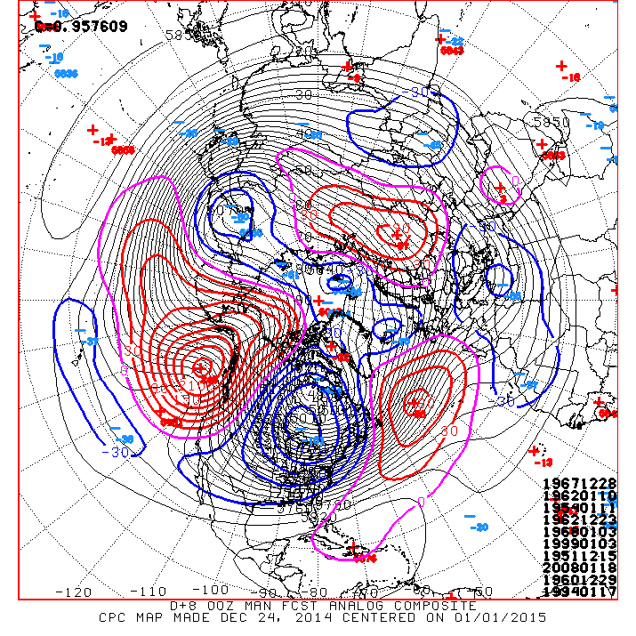
Here's a look at the CPC's analogs for 6-10 days from now:
Noticed Jan 10 1962 second on the list, that was a significant outbreak with record high pressure I believe.
I was going to mention that the PV height anomaly looks to be headed for Hudson Bay after New Year's. 500mb heights have been very low into the US on some recent model runs, just something to follow.srainhoutx wrote:Another phenomenon that is worth mentioning and may well be the 'driver' of this pattern change to a colder regime is that the GFS and ECMWF has been very insistent that past couple of days in splitting the Polar Vortex which has been near the N Pole as it typically is. This sort of event usually spells trouble for those looking for warmer weather in the Winter months and the computer models are responding to such a shift that looks to bring a Polar Vortex into Canada near Hudson Bay.
ronyan how about taking tomorrow off,and getting back to work Friday. 
-
TexasBreeze
- Posts: 943
- Joined: Sun Sep 26, 2010 4:46 pm
- Location: NW Houston, TX
- Contact:
Somethings to keep in mind. Often I hear of forecasts "catching up" to the speed and lower temps of arctic fronts when they end up on the move down here. The airmasses tend to hang around too before modifying, especially with cloud cover and precip.
Merry Christmas from me too!:)
Merry Christmas from me too!:)
-
srainhoutx
- Site Admin
- Posts: 19616
- Joined: Tue Feb 02, 2010 2:32 pm
- Location: Maggie Valley, NC
- Contact:
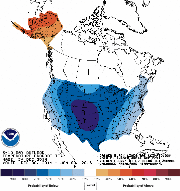
Here is the Prognostic Discussion for this range:ronyan wrote:Wishing everyone on the board a Merry Christmas. I'll probably take a break from model watching for a day or so.
Here's a look at the CPC's analogs for 6-10 days from now:
Noticed Jan 10 1962 second on the list, that was a significant outbreak with record high pressure I believe.
PROGNOSTIC DISCUSSION FOR 6 TO 10 AND 8 TO 14 DAY OUTLOOKS
NWS CLIMATE PREDICTION CENTER COLLEGE PARK, MD
300 PM EST WED DECEMBER 24 2014
6-10 DAY OUTLOOK FOR DEC 30, 2014 - JAN 03, 2015
TODAY'S MODEL SOLUTIONS CONTINUE TO DIFFER ON THE ORIENTATION OF THE LONGWAVE
TROUGH AXIS EXPECTED ACROSS THE LOWER 48. MODEL CONTINUITY AMONG THE HIGH
RESOLUTION MODEL RUNS IS POOR RANGING FROM YESTERDAY'S 12Z SOLUTIONS FEATURING
A FULL LATITUDE TROUGH CENTERED OVER THE EAST-CENTRAL CONUS, TO TODAY'S 0Z
SOLUTIONS DEPICTING A POSITIVELY TILTED TROUGH EXTENDING FROM HUDSON BAY
SOUTHWEST TO NORTHERN MEXICO. DUE TO THE LACK OF CONTINUITY, NO HIGH RESOLUTION
MODEL RUNS ARE USED IN CREATING THE 500-HPA BLEND. TELECONNECTIONS ON A WELL
AGREED UPON POSITIVE 500-HPA HEIGHT ANOMALY CENTER NEAR BRITISH COLUMBIA AT
50N-140W DOES NOT FAVOR THE PROGRESSIVE LONGWAVE TROUGH PREDICTED BY THE 0Z
CANADIAN ENSEMBLE MEAN. THE 500-HPA MANUAL BLEND IS CREATED USING THE 0Z/6Z GFS
AND 0Z ECMWF ENSEMBLE MEANS WHICH MAINTAINS GOOD CONTINUITY WITH YESTERDAY'S
MANUAL BLEND AND IS SUPPORTED BY THE AFOREMENTIONED TELECONNECTION.
DESPITE UNCERTAINTY ON THE ORIENTATION OF THE LONGWAVE TROUGH AXIS, TEMPERATURE
TOOLS INCLUDING GUIDANCE DERIVED FROM THE TELECONNECTION FAVOR BELOW-NORMAL
TEMPERATURES FOR A MAJORITY OF THE CONUS. THE HIGHEST ODDS FOR BELOW-NORMAL
TEMPERATURES ARE FORECAST ACROSS THE CENTRAL ROCKIES AND CENTRAL/SOUTHERN
PLAINS WHERE A 1048-HPA OR STRONGER SURFACE HIGH IS EXPECTED TO BUILD SOUTH
EARLY IN THE PERIOD. NEAR NORMAL TEMPERATURES ARE FAVORED FOR PARTS OF
CALIFORNIA WHERE A WARMING TREND IS EXPECTED LATER IN THIS PERIOD, WHILE A
SHIFTING TEMPERATURE PATTERN FAVORS NEAR NORMAL TEMPERATURES FOR THE FLORIDA
PENINSULA AND COASTAL SOUTHEAST.
SINCE THE NORTHERN STREAM IS EXPECTED TO BECOME MORE DOMINANT BY THE NEW YEAR,
A DRIER PATTERN IS LIKELY FOR MUCH OF THE CONUS BY EARLY JANUARY. A LOW
PRESSURE SYSTEM IS EXPECTED TO RAPIDLY EXIT THE EAST COAST BY DAY 6 WITH LITTLE
OR NO EFFECT ON THE PRECIPITATION OUTLOOK. THE LACK OF A BLOCKING RIDGE OF HIGH
PRESSURE OVER THE NORTH ATLANTIC IS LIKELY TO RESULT IN FAST-MOVING AND
RELATIVELY WEAK LOW PRESSURE SYSTEMS FOR THE EAST COAST. THEREFORE, NEAR TO
BELOW-MEDIAN PRECIPITATION IS FAVORED ACROSS THE NORTHEAST. UPSLOPE FLOW EARLY
IN THE PERIOD TILTS THE ODDS TOWARDS ABOVE-MEDIAN PRECIPITATION ACROSS
SOUTHEAST COLORADO AND EASTERN NEW MEXICO. LATER IN THE PERIOD, A SLOW RETURN
OF LOW-LEVEL MOISTURE AND THE POTENTIAL FOR CYCLOGENESIS NEAR THE GULF COAST
FAVOR NEAR TO ABOVE-MEDIAN PRECIPITATION ACROSS THE GULF COAST STATES AND PARTS
OF THE SOUTHEAST. THE UPPER-LEVEL RIDGE FORECAST UPSTREAM OVER THE NORTHEAST
PACIFIC FAVORS BELOW-MEDIAN PRECIPITATION FOR THE WESTERN CONUS.
ANOMALOUS SOUTHERLY FLOW AND ABOVE-NORMAL 500-HPA HEIGHTS INCREASE CHANCES FOR
ABOVE-NORMAL TEMPERATURES ACROSS ALASKA. 5-DAY PRECIPITATION AMOUNTS FROM THE
0Z GFS AND 0Z ECMWF ENSEMBLE MEANS ARE DECREASING FROM PREVIOUS MODEL RUNS
WHICH IS CONSISTENT WITH FORECASTS OF A BUILDING 500-HPA RIDGE. THE TROUGH OVER
THE BERING SEA INCREASES CHANCES FOR ABOVE-MEDIAN PRECIPITATION ACROSS WESTERN
ALASKA.
TODAY'S OFFICIAL 500-HPA BLEND CONSISTS OF 25% OF TODAY'S 0Z GFS ENSEMBLE MEAN
CENTERED ON DAY 8, 25% OF TODAY'S 6Z GFS ENSEMBLE MEAN CENTERED ON DAY 8, AND
50% OF TODAY'S 0Z EUROPEAN ENSEMBLE MEAN CENTERED ON DAY 8
MODEL OF THE DAY: 0Z ECMWF ENSEMBLE MEAN
FORECAST CONFIDENCE FOR THE 6-10 DAY PERIOD: AVERAGE, 3 OUT OF 5, DUE TO GOOD
AGREEMENT AMONG THE TEMPERATURE TOOLS OFFSET BY POOR CONTINUITY AMONG THE HIGH
RESOLUTION MODEL RUNS AND INCREASING ENSEMBLE SPREAD ACROSS THE NORTHEAST
PACIFIC.
Carla/Alicia/Jerry(In The Eye)/Michelle/Charley/Ivan/Dennis/Katrina/Rita/Wilma/Humberto/Ike/Harvey
Member: National Weather Association
Facebook.com/Weather Infinity
Twitter @WeatherInfinity
Member: National Weather Association
Facebook.com/Weather Infinity
Twitter @WeatherInfinity
-
Portastorm

- Posts: 800
- Joined: Wed Feb 03, 2010 3:04 pm
- Location: Southwest Austin/Oak Hill, TX
- Contact:
Interesting snippet from the NWS Austin/San Antonio (EWX) afternoon forecast discussion:
NOW FOR THE MOST INTERESTING PART OF THE FORECAST. AS THIS TROUGH
MOVES OUT SUNDAY...THE NEXT STORM SYSTEM WILL BE TAKING SHAPE
ACROSS THE NORTHWEST CONUS SUNDAY EVENING. A VERY AMPLIFIED RIDGE
AXIS WILL BE EXTENDED OFF THE WESTERN CONUS...NORTH INTO THE
CANADA/ALASKA BORDER WITH 500 HEIGHTS NEAR 570DM REACHING 60 DEGREES
NORTH. THIS IS A STANDARDIZED ANOMALY OF ABOUT ABOUT 3 STANDARD
DEVIATIONS ABOVE NORMAL FOR THAT REGION. TO THE EAST OF THIS RIDGE
AXIS A VERY DEEP TROUGH AXIS IS ABLE TO THEN DIG SOUTHWEST WITH THE
MAIN RIDGE AXIS ORIENTED FROM NEAR NORTH DAKOTA BACK INTO ARIZONA
MONDAY EVENING. THIS UPPER PATTERN IS TYPICALLY KNOWN FOR BRINGING
COLD ARCTIC AIRMASSES INTO TEXAS. MODELS ARE FORECASTING THE SURFACE
HIGH BEHIND THE ASSOCIATED COLD FRONT TO ENTER THE CONUS NEAR
MONTANA SUNDAY. SURFACE HIGHS WHICH ENTER IN THIS REGION ARE KNOWN
TO BE FAVORABLE FOR THE COLDEST AIRMASSES FOR THE SOUTHERN PLAINS.
THIS IS MOSTLY DUE TO COLD AIR DAMMING WHICH OCCURS AS THE COLD
AIRMASS MOVES SOUTH ON THE LEE SIDE OF THE ROCKIES. AS THE HIGH
CIRCULATION DROPS SOUTH...EAST WINDS ON THE SOUTHERN PERIPHERY GET
BLOCKED BY THE TERRAIN AND THE COLD AIR IS ALLOWED TO POOL AND
COLLECT AS THE HIGH MOVES SOUTH. THIS ALLOWS THE AIR TO BECOME MORE
DENSE WHICH EQUATES TO COLDER AIR. IT WILL BE INTERESTING TO SEE HOW
THIS SYSTEM PLAYS OUT...BUT MODELS TEND TO BE TOO WARM WITH
TEMPERATURES WITH THIS PATTERN BY THE TIME THE COLD AIR MAKES IT
INTO TEXAS. ANOTHER INTERESTING PIECE TO THIS PUZZLE IS MODELS ARE
IN FAIRLY GOOD AGREEMENT THAT A PIECE OF THE TROUGH WILL MOVE
THROUGH THE AREA SOMETIME NEXT WEEK AFTER THE COLD AIR MAKES IT.
THERE ARE TIMING AND STRENGTH DISCREPANCIES BETWEEN THE MEDIUM-RANGE
GUIDANCE AND THIS IS LIKELY TO BE THE CASE FOR THE NEXT SEVERAL
DAYS. HOWEVER...MODELS THEN DO AGREE ON ENOUGH MOISTURE FOR PRECIP
WITH THE SYSTEM. THE QUESTION THEN TURNS TO HOW TO CONVEY THE
POSSIBILITY OF WINTER PRECIP IN THE OFFICIAL FORECAST FOR DAY 7. FOR
NOW...WILL MENTION A RAIN OR FREEZING RAIN MIX FOR THE HILL COUNTRY
TUESDAY NIGHT. THIS IS A GOOD START BECAUSE THERE ARE SOME TIMING
AND STRENGTH DIFFERENCES WITH THE TROUGH AS IT MOVES THROUGH THE
REGION. THERE IS THE POTENTIAL THAT THE AIR MASS WILL COLDER THAN
WHAT THE GFS IS SUGGESTING...SIMILAR TO THE ECMWF SOLUTION FOR
TEMPS. THIS BEARS WATCHING AS THE FORECAST IS LIKELY TO CHANGE ONE
WAY OR THE OTHER AS THE NEXT WEEK PROGRESSES.
-
srainhoutx
- Site Admin
- Posts: 19616
- Joined: Tue Feb 02, 2010 2:32 pm
- Location: Maggie Valley, NC
- Contact:
Christmas Eve briefing from Jeff:
Increasing potential for strong arctic intrusion next week with possible winter storm 12/31-1/2.
Cold advection continues today with NW winds and temperatures in the 50’s which will set the stage for a cold and clear night and mostly sunny and cool Christmas with lows in the 30’s and highs in the 60’s.
Rapid changes underway on Friday as moisture returns ahead of the next incoming Pacific system. Clouds will increase and moisture may be enough by afternoon to support a few showers. Next cold front crosses the area Saturday night with showers and thunderstorms likely and then a period of post frontal upglide and rain Saturday night into at least the first part of Sunday with cold conditions. Overall the upcoming weekend will cool to cold and wet.
Next week:
Much of the focus continues to be on the middle to end of next week as very cold air looks increasingly likely to head southward. Strong upper level jet stream amplification will begin late this week with deep layer ridging pushing deep into Alaska and as far as 60 degrees north with the formation of a formidable downstream trough over the western and central US. Models are coming into decent agreement on this pattern and a very cold air mass dislodging from NW Canada and dropping southward under a large 1050mb+ arctic high pressure cell into Montana. This is an extremely favorable pattern to deliver very cold air to TX as the air mass dams against the Rockies mountains and surges quickly southward. Model guidance is almost certainly under-estimating the amount of cold air and likely is too slow in its arrival. Looks like the arctic front will enter TX next Tuesday and roar southward and off the coast next Wednesday…could be slightly faster than that with some models showing a 1045-1050mb high dropping as far south as Colorado out of WY and 1035-1040mb pressures into NW TX. Temperatures will tumble behind the frontal passage with strong cold air advection. Will need to undercut guidance, but not sure how much at this point given potential clouds and linger post frontal precipitation. Not looking at anything record breaking, but possible for a period of sub freezing temperatures even for daytime highs during the latter part of next week and the first weekend of 2015.
Forecast models continue to suggest a portion of the positive tilted trough hangs back over the SW US allowing period of moisture to upglide over the arctic dome and produce periods of precipitation. Model soundings are showing mainly rain and freezing rain profiles for SE TX around New Year’s Eve and Day….but given how poorly they handle such air masses they are likely too warm and too far NW with their freezing rain. Depending on the amount of moisture it looks like temperatures will be cold enough to support P-type concerns across a good portion of TX and SE TX and this is something that will have to be watched closely over the next few days as details begin to firm up on what sort of storm system we may be facing ejecting across in the cold air mass. Overall setup looks favorable for a winter storm across TX New Year’s Eve and Day.
Carla/Alicia/Jerry(In The Eye)/Michelle/Charley/Ivan/Dennis/Katrina/Rita/Wilma/Humberto/Ike/Harvey
Member: National Weather Association
Facebook.com/Weather Infinity
Twitter @WeatherInfinity
Member: National Weather Association
Facebook.com/Weather Infinity
Twitter @WeatherInfinity
-
Katdaddy

- Global Moderator

- Posts: 2502
- Joined: Thu Feb 04, 2010 8:18 am
- Location: League City, Tx
- Contact:
Interesting days ahead. From the Houston-Galveston NWS disco this afternoon:
A RATHER COOL AFTERNOON WITH MAX TEMPS STRUGGLING TO WARM INTO THE
UPPER 50S. CLOUD COVER OVER THE EASTERN HALF OF THE AREA WILL EXIT
THE REGION BY SUNSET LEAVING CLEAR SKIES OVERNIGHT. WINDS WILL
ALSO DECOUPLE AS SFC HIGH PRESSURE OVER NORTHERN MEXICO DRIFTS
EAST. THE HIGH WILL BE EAST OF THE REGION ON THURSDAY AND WINDS
WILL BECOME ONSHORE AND STRENGTHEN AS LOW PRESSURE OVER SE
COLORADO DEEPENS. MOISTURE LEVELS WILL DEEPEN ON FRIDAY AS ONSHORE
WINDS PERSIST. PW VALUES ON FRIDAY REACH 1.10 AND FCST SOUNDINGS
SATURATE TO AROUND 800 MB. MOISTURE LOOKS DEEP ENOUGH TO GENERATE
A FEW SHOWERS BY FRI AFTN. PW VALUES REACH 1.40 INCHES ON SATURDAY
AHEAD OF ANOTHER COLD FRONT. THE FRONT WILL TRIGGER SCATTERED
SHOWERS AND THUNDERSTORMS AS IT CROSSES THE AREA. POST FRONTAL
RAIN WILL LIKELY PERSIST SAT NITE INTO EARLY SUNDAY AS THE FLOW
ALOFT REMAINS OUT OF THE SOUTHWEST AND SFC WINDS WILL BE NORTH.
ISENTROPIC UPGLIDE SHOULD BE MAXIMIZED SAT NIGHT. A S/WV TROUGH
WILL APPROACH THE PACIFIC COAST ON SATURDAY NIGHT AND THIS
FEATURE WILL NUDGE ANOTHER S/WV OVER SW TX EASTWARD. THE TEXAS
S/WV FILLS AS IT MOVES EAST AND THE FLOW ALOFT BECOMES ZONAL BY
MON 00Z. THE SET UP FOR ISENTROPIC UPGLIDE ON SUNDAY WHICH LOOKED
EXTREMELY FAVORABLE 24 HOURS AGO LOOKS CONSIDERABLY LESS FAVORABLE
NOW. THE CANADIAN CONTINUES TO SHOW SOME POTENTIAL FOR ISENTROPIC
UPGLIDE WHILE THE GFS AND ECMWF HAVE BACKED OFF. GLOBAL MODELS
CONTINUE TO SHOW SE TX IN A POTENT 155 KT RRQ WHICH SHOULD ENHANCE
PRECIP THROUGH EARLY SUN AFTN. SUBSIDENCE IN THE WAKE OF THE
DEPARTING S/WV SHOULD ALLOW FOR A BRIEF PERIOD OF DRY WEATHER AND
CLEARING SKIES ON MONDAY. ANOTHER UPPER TROUGH WILL DEVELOP OVER
THE SW U.S. AND ISENTROPIC UPGLIDE DEVELOPS AGAIN ON TUESDAY WITH
CLOUDS AND LIGHT RAIN RETURNING. THE ECMWF IS BRINGING VERY COLD
AIR INTO TEXAS AROUND THE NEW YEARS HOLIDAY AND FCST SOUNDINGS DO
SHOW SOME POTENTIAL FOR SLEET/FRZ RAIN NORTH OF A BRYAN TO
LIVINGSTON LINE.
-
Paul Robison
Any chance of extensive power outages, rotating blackouts, and other energy maladies with this weather system? I couldn't help but notice Jeff mentioning freezing temperatures for daytime highs. All opinions are welcome.
Last edited by Paul Robison on Wed Dec 24, 2014 10:26 pm, edited 1 time in total.