
Thank you...this is lovely since I have to leave the house at 2:30svrwx0503 wrote:Right now it looks like the main threats with those storms right now will be dangerous lightning, some gusty winds and maybe some small hail. Since they do not look to be moving very fast, some localized flooding will also be a concern in your typical low lying spots.rnmm wrote:Hearing lots of thunder overhead we need the rain so I welcome it...I just don't want it to get real bad...can someone please tell me how big of a severe threat this/these storms are? Thank you as always
May Weather Discussion.
My name is Nicole and I love weather!!
~~~~~~~~~~~~~~~~~~~~~~~~~~~~~~~~~~~~~~~~~~~~~~~~~~~~~~~~~~~~~~~~~~~~~~~~~~~~~~~~~~~~~~~~~~~~~~~~
Alicia, Allison, Rita, Ike
~~~~~~~~~~~~~~~~~~~~~~~~~~~~~~~~~~~~~~~~~~~~~~~~~~~~~~~~~~~~~~~~~~~~~~~~~~~~~~~~~~~~~~~~~~~~~~~~
Alicia, Allison, Rita, Ike

Thunder in Texas City, skies looking ominous.


Radar showing 40-45mph winds just above the ground south of Dickinson and just northeast of Santa Fe so look out for some pretty gusty winds with some of the storms.
svrwx0503 wrote:Radar showing 40-45mph winds just above the ground south of Dickinson and just northeast of Santa Fe so look out for some pretty gusty winds with some of the storms.
Thank you svrwx for keeping us updated...I will continue to check but I am afraid we will lose electricity soon...it is already blinking in and out
My name is Nicole and I love weather!!
~~~~~~~~~~~~~~~~~~~~~~~~~~~~~~~~~~~~~~~~~~~~~~~~~~~~~~~~~~~~~~~~~~~~~~~~~~~~~~~~~~~~~~~~~~~~~~~~
Alicia, Allison, Rita, Ike
~~~~~~~~~~~~~~~~~~~~~~~~~~~~~~~~~~~~~~~~~~~~~~~~~~~~~~~~~~~~~~~~~~~~~~~~~~~~~~~~~~~~~~~~~~~~~~~~
Alicia, Allison, Rita, Ike
SPECIAL WEATHER STATEMENT
NATIONAL WEATHER SERVICE HOUSTON/GALVESTON TX
202 PM CDT TUE MAY 18 2010
TXZ237-238-182000-
BRAZORIA-GALVESTON-
202 PM CDT TUE MAY 18 2010
...STRONG THUNDERSTORMS OVER BRAZORIA AND GALVESTON COUNTIES...
AT 155 PM CDT...NATIONAL WEATHER SERVICE DOPPLER RADAR INDICATED A
CLUSTER OF STRONG THUNDERSTORMS FROM DANBURY TO SANTA FE. THESE
STORMS WERE DRIFTING SLOWLY NORTHWARD.
ONE HALF INCH DIAMETER HAIL...WINDS GREATER THAN 40 MPH...FREQUENT
CLOUD TO GROUND LIGHTNING...BRIEF HEAVY DOWNPOURS...ARE POSSIBLE WITH
THIS STORM.
LOCATIONS IN THE PATH OF THIS STORM INCLUDE...CHOCOLATE BAYOU...TEXAS
CITY...SANTA FE...LIVERPOOL...LEAGUE CITY...LA MARQUE...HITCHCOCK...
HILLCREST...DICKINSON...BACLIFF AND ALVIN.
GUSTY WINDS MAY CAUSE UNSECURED SMALL OBJECTS SUCH AS TRASH CANS TO
BLOW AROUND. AVOID TALL OUTDOOR OBJECTS THAT CAN ATTRACT LIGHTNING.
IF YOU ARE OUTDOORS AND HEAR THUNDER...YOU ARE CLOSE ENOUGH TO BE
STRUCK BY LIGHTNING. SEEK SHELTER IN A STURDY STRUCTURE OR
NON-CONVERTABLE AUTOMOBILE UNTIL THIS STORM HAS PASSED.
There is a considerable amount of lightning with these storms so be careful out there.
Area of strongest winds around 45-55mph look to be headed towards the NWS office....
It's obviously a bit early for it but all the clouds just off the Texas/Mexican border remind you it's about that time.
It is starting to calm down now...I looked at the radar and it seems there is another storm building behind that one...am I just imagining that? I am still learning...thank you 
My name is Nicole and I love weather!!
~~~~~~~~~~~~~~~~~~~~~~~~~~~~~~~~~~~~~~~~~~~~~~~~~~~~~~~~~~~~~~~~~~~~~~~~~~~~~~~~~~~~~~~~~~~~~~~~
Alicia, Allison, Rita, Ike
~~~~~~~~~~~~~~~~~~~~~~~~~~~~~~~~~~~~~~~~~~~~~~~~~~~~~~~~~~~~~~~~~~~~~~~~~~~~~~~~~~~~~~~~~~~~~~~~
Alicia, Allison, Rita, Ike

I just got in and brought up the radar. There does seem to be another storm developing down by Angleton, however it's been moving little (although the Nexrad shows it moving northwestward.)rnmm wrote:It is starting to calm down now...I looked at the radar and it seems there is another storm building behind that one...am I just imagining that? I am still learning...thank you
What's caught my eye is the outflow now moving northward into southern Harris. We now wait to see if it will trigger more storms this afternoon.
It's amazing how (at least for now) everything has collapsed.
wxdata wrote:I just got in and brought up the radar. There does seem to be another storm developing down by Angleton, however it's been moving little (although the Nexrad shows it moving northwestward.)rnmm wrote:It is starting to calm down now...I looked at the radar and it seems there is another storm building behind that one...am I just imagining that? I am still learning...thank you
What's caught my eye is the outflow now moving northward into southern Harris. We now wait to see if it will trigger more storms this afternoon.
Is is safe to assume Galveston County is out of the way of storms now? This one I agree did collapse really fast...
My name is Nicole and I love weather!!
~~~~~~~~~~~~~~~~~~~~~~~~~~~~~~~~~~~~~~~~~~~~~~~~~~~~~~~~~~~~~~~~~~~~~~~~~~~~~~~~~~~~~~~~~~~~~~~~
Alicia, Allison, Rita, Ike
~~~~~~~~~~~~~~~~~~~~~~~~~~~~~~~~~~~~~~~~~~~~~~~~~~~~~~~~~~~~~~~~~~~~~~~~~~~~~~~~~~~~~~~~~~~~~~~~
Alicia, Allison, Rita, Ike
For now, yes.rnmm wrote:
Is is safe to assume Galveston County is out of the way of storms now? This one I agree did collapse really fast...
Thank youwxdata wrote:For now, yes.rnmm wrote:
Is is safe to assume Galveston County is out of the way of storms now? This one I agree did collapse really fast...
My name is Nicole and I love weather!!
~~~~~~~~~~~~~~~~~~~~~~~~~~~~~~~~~~~~~~~~~~~~~~~~~~~~~~~~~~~~~~~~~~~~~~~~~~~~~~~~~~~~~~~~~~~~~~~~
Alicia, Allison, Rita, Ike
~~~~~~~~~~~~~~~~~~~~~~~~~~~~~~~~~~~~~~~~~~~~~~~~~~~~~~~~~~~~~~~~~~~~~~~~~~~~~~~~~~~~~~~~~~~~~~~~
Alicia, Allison, Rita, Ike
Wow.... thunder, ominous skies, 5 drops of rain, and now.... SUN AND STEAMBATH in Texas City! Sauna anyone??? 
-
sleetstorm
- Posts: 651
- Joined: Thu Feb 04, 2010 12:33 pm
- Contact:
So much for southeast Texas' opportunity for strong-severe thunderstorms, huh?
i watched it for about an hour or so...too bad it was rain-wrapped most of the time.Ed Mahmoud wrote:
Did anyone watch Vortex chasing the cycling tornadic supercell near Dumass Texas? On TWC. OK, dull today locally, although the seabreeze front is good for 20% per NWS, but I-20 to I-40, near Dallas to Oklahoma City, should be an interesting afternoon.
today should be an amazing day for V2. i'm pretty excited to get home after work and tune in. looks like today could be another day like may 10 was.
Central OK upped to high risk now. SPC:
THE STORMS WILL QUICKLY BECOME SUPERCELLS GIVEN 40-50 KT DEEP WSWLY
SHEAR AND SBCAPE OF 2500-3000 J/KG. THE SETUP APPEARS MOST
FAVORABLE FOR LARGE...RELATIVELY SLOW MOVING INTENSE STORMS WITH
LARGE HAIL. GIVEN SIZABLE LOW LVL DIRECTIONAL COMPONENT TO
SHEAR...ESPECIALLY NEAR REMNANT OUTFLOW BOUNDARY AND/OR FRONT...A
COUPLE STRONG TORNADOES ALSO MAY OCCUR.
-
srainhoutx

- Site Admin

- Posts: 19616
- Joined: Tue Feb 02, 2010 2:32 pm
- Location: Maggie Valley, NC
- Contact:
Now this is interesting...
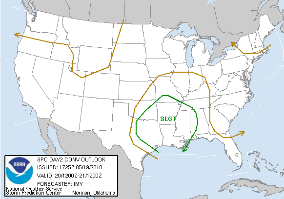
DAY 2 CONVECTIVE OUTLOOK
NWS STORM PREDICTION CENTER NORMAN OK
1225 PM CDT WED MAY 19 2010
VALID 201200Z - 211200Z
...THERE IS A SLGT RISK OF SVR TSTMS FROM ERN TX/OK EWD ACROSS
AR/LA/MS AND INTO WRN AL/TN...
...SYNOPSIS...
AN UPPER LEVEL TROUGH FROM NEB/KS SWD INTO CENTRAL TX AT DAYBREAK IS
FORECAST TO EJECT SLIGHTLY NEGATIVELY-TILTED ACROSS THE LOWER/MS
VALLEY...AS A STRONG UPPER TROUGH DEEPENS AND MOVES EWD ACROSS THE
WRN STATES. MODELS ONLY SUGGEST A WEAK SURFACE TROUGH WILL BE
ASSOCIATED WITH UPPER TROUGH...WITH A MINOR SURFACE LOW LOCATED IN
WRN MO AND TRAILING SURFACE FRONT/TROUGH EXTENDING SWWD INTO NRN TX.
ALSO...WHILE THE SYNOPTIC WARM FRONT MAY BE IN MO...MORNING
CONVECTION IS LIKELY TO MAINTAIN A SUBTLE WARM FRONT FROM THE
ARKLATEX REGION SEWD INTO SRN AL DURING THE DAY THU.
...ERN TX/OK EWD ACROSS AR/LA/MS AND INTO WRN TN/AL...
SEVERE EVOLUTION ON THU WILL BE COMPLICATED BY WIDESPREAD CONVECTION
THAT IS EXPECTED TO BE ONGOING AT 12Z FROM MO/AR SWWD INTO SERN
OK/NRN TX. ALTHOUGH THE UPDRAFTS MAY BE SLIGHTLY DECOUPLED FROM
BOUNDARY LAYER...SHEAR AND INSTABILITY WILL BE FAVORABLE FOR THESE
STORMS TO BE SEVERE ACROSS AR...WRN TN...SERN OK AND NRN TX DURING
THE MORNING. PRIMARY THREAT SHOULD BE WIND DAMAGE AS CONGEALED
DOWNDRAFTS SHOULD HAVE CONSOLIDATED STORMS INTO ONE OR MORE MCS/S.
HOWEVER...WIND PROFILES/MODERATE INSTABILITY MAY ALSO SUPPORT AN
ISOLATED TORNADO AND SEVERE HAIL THREAT.
NAM/GFS SHOW DIFFERENT EVOLUTION OF CONVECTIVE PCPN ON THU. NAM HAS
BEEN CONSISTENT IN MORNING STORMS BEING MAINTAINED AND INTENSIFYING
AS A FORWARD PROPAGATING QLCS FROM THE ARKLATEX ESEWD ALONG BOUNDARY
INTO MS DURING THE AFTERNOON. THIS SOLUTION APPEARS MOST REASONABLE
GIVEN THE STRONG FORCING SPREADING EWD IN ASSOCIATION WITH THE UPPER
TROUGH. THE STRONG INSTABILITY AND FORECAST LINE MOTION AT 40-50 KT
WOULD BE VERY SUPPORTIVE OF DAMAGING WINDS...SOME WHICH COULD BE
SIGNIFICANT. ADDITIONALLY... THE LOW/DEEP LAYER SHEAR WOULD SUPPORT
TORNADOES WITHIN EMBEDDED BOWS. IF THIS SCENARIO APPEARS
LIKELY...PORTIONS OF AREA MAY BE UPGRADED TO A MODERATE RISK ON
UPCOMING DAY 1 OUTLOOKS.
FURTHER WEST ACROSS ERN OK AND NRN TX...AFTER MORNING CONVECTION
SHIFTS EAST OF THE AREA...PARTY CLOUDY SKIES SHOULD ALLOW
TEMPERATURES TO WARM INTO THE UPPER 70S AND 80S. THESE READINGS PLUS
THE MOIST BOUNDARY LAYER...EAST OF SURFACE TROUGH...WILL RESULT IN
MLCAPE VALUES FROM 2000-3000 J/KG. WEAK CONVERGENCE AND POSSIBLE
SUBSIDENCE BEHIND MCS OVER THE LOWER MS VALLEY MAY LIMIT STORM
COVERAGE. HOWEVER...MID LEVEL SPEED MAX COMBINED WITH STRONG
INSTABILITY AND 40-50 KT DEEP LAYER SHEAR WOULD SUPPORT AT LEAST
ISOLATED INTENSE SUPERCELLS BY LATE AFTERNOON. WHILE THE DEGREE OF
SHEAR AND VERY MOIST BOUNDARY LAYER MIGHT SUPPORT A TORNADO OR
TWO...RELATIVELY WEAK WINDS FROM THE SURFACE-700 MB SUGGEST THAT
VERY LARGE HAIL AND WIND DAMAGE WOULD BE THE PRIMARY THREATS WITH
THESE STORMS.
..IMY.. 05/19/2010
Carla/Alicia/Jerry(In The Eye)/Michelle/Charley/Ivan/Dennis/Katrina/Rita/Wilma/Humberto/Ike/Harvey
Member: National Weather Association
Facebook.com/Weather Infinity
Twitter @WeatherInfinity
Member: National Weather Association
Facebook.com/Weather Infinity
Twitter @WeatherInfinity
-
sleetstorm
- Posts: 651
- Joined: Thu Feb 04, 2010 12:33 pm
- Contact:
What does that connote for those of us here in north central, northeast, eastern, and southeast Texas, srainhoutx?srainhoutx wrote:Now this is interesting...
DAY 2 CONVECTIVE OUTLOOK
NWS STORM PREDICTION CENTER NORMAN OK
1225 PM CDT WED MAY 19 2010
VALID 201200Z - 211200Z
...THERE IS A SLGT RISK OF SVR TSTMS FROM ERN TX/OK EWD ACROSS
AR/LA/MS AND INTO WRN AL/TN...
...SYNOPSIS...
AN UPPER LEVEL TROUGH FROM NEB/KS SWD INTO CENTRAL TX AT DAYBREAK IS
FORECAST TO EJECT SLIGHTLY NEGATIVELY-TILTED ACROSS THE LOWER/MS
VALLEY...AS A STRONG UPPER TROUGH DEEPENS AND MOVES EWD ACROSS THE
WRN STATES. MODELS ONLY SUGGEST A WEAK SURFACE TROUGH WILL BE
ASSOCIATED WITH UPPER TROUGH...WITH A MINOR SURFACE LOW LOCATED IN
WRN MO AND TRAILING SURFACE FRONT/TROUGH EXTENDING SWWD INTO NRN TX.
ALSO...WHILE THE SYNOPTIC WARM FRONT MAY BE IN MO...MORNING
CONVECTION IS LIKELY TO MAINTAIN A SUBTLE WARM FRONT FROM THE
ARKLATEX REGION SEWD INTO SRN AL DURING THE DAY THU.
...ERN TX/OK EWD ACROSS AR/LA/MS AND INTO WRN TN/AL...
SEVERE EVOLUTION ON THU WILL BE COMPLICATED BY WIDESPREAD CONVECTION
THAT IS EXPECTED TO BE ONGOING AT 12Z FROM MO/AR SWWD INTO SERN
OK/NRN TX. ALTHOUGH THE UPDRAFTS MAY BE SLIGHTLY DECOUPLED FROM
BOUNDARY LAYER...SHEAR AND INSTABILITY WILL BE FAVORABLE FOR THESE
STORMS TO BE SEVERE ACROSS AR...WRN TN...SERN OK AND NRN TX DURING
THE MORNING. PRIMARY THREAT SHOULD BE WIND DAMAGE AS CONGEALED
DOWNDRAFTS SHOULD HAVE CONSOLIDATED STORMS INTO ONE OR MORE MCS/S.
HOWEVER...WIND PROFILES/MODERATE INSTABILITY MAY ALSO SUPPORT AN
ISOLATED TORNADO AND SEVERE HAIL THREAT.
NAM/GFS SHOW DIFFERENT EVOLUTION OF CONVECTIVE PCPN ON THU. NAM HAS
BEEN CONSISTENT IN MORNING STORMS BEING MAINTAINED AND INTENSIFYING
AS A FORWARD PROPAGATING QLCS FROM THE ARKLATEX ESEWD ALONG BOUNDARY
INTO MS DURING THE AFTERNOON. THIS SOLUTION APPEARS MOST REASONABLE
GIVEN THE STRONG FORCING SPREADING EWD IN ASSOCIATION WITH THE UPPER
TROUGH. THE STRONG INSTABILITY AND FORECAST LINE MOTION AT 40-50 KT
WOULD BE VERY SUPPORTIVE OF DAMAGING WINDS...SOME WHICH COULD BE
SIGNIFICANT. ADDITIONALLY... THE LOW/DEEP LAYER SHEAR WOULD SUPPORT
TORNADOES WITHIN EMBEDDED BOWS. IF THIS SCENARIO APPEARS
LIKELY...PORTIONS OF AREA MAY BE UPGRADED TO A MODERATE RISK ON
UPCOMING DAY 1 OUTLOOKS.
FURTHER WEST ACROSS ERN OK AND NRN TX...AFTER MORNING CONVECTION
SHIFTS EAST OF THE AREA...PARTY CLOUDY SKIES SHOULD ALLOW
TEMPERATURES TO WARM INTO THE UPPER 70S AND 80S. THESE READINGS PLUS
THE MOIST BOUNDARY LAYER...EAST OF SURFACE TROUGH...WILL RESULT IN
MLCAPE VALUES FROM 2000-3000 J/KG. WEAK CONVERGENCE AND POSSIBLE
SUBSIDENCE BEHIND MCS OVER THE LOWER MS VALLEY MAY LIMIT STORM
COVERAGE. HOWEVER...MID LEVEL SPEED MAX COMBINED WITH STRONG
INSTABILITY AND 40-50 KT DEEP LAYER SHEAR WOULD SUPPORT AT LEAST
ISOLATED INTENSE SUPERCELLS BY LATE AFTERNOON. WHILE THE DEGREE OF
SHEAR AND VERY MOIST BOUNDARY LAYER MIGHT SUPPORT A TORNADO OR
TWO...RELATIVELY WEAK WINDS FROM THE SURFACE-700 MB SUGGEST THAT
VERY LARGE HAIL AND WIND DAMAGE WOULD BE THE PRIMARY THREATS WITH
THESE STORMS.
..IMY.. 05/19/2010
Last edited by sleetstorm on Wed May 19, 2010 3:22 pm, edited 1 time in total.