January: Calmer Pattern To End The Month
-
srainhoutx

- Site Admin

- Posts: 19700
- Joined: Tue Feb 02, 2010 2:32 pm
- Location: Maggie Valley, NC
- Contact:
Moderate sleet and snow now in NW Harris County.
Carla/Alicia/Jerry(In The Eye)/Michelle/Charley/Ivan/Dennis/Katrina/Rita/Wilma/Humberto/Ike/Harvey
Member: National Weather Association
Facebook.com/Weather Infinity
Twitter @WeatherInfinity
Member: National Weather Association
Facebook.com/Weather Infinity
Twitter @WeatherInfinity
-
djjordan

- Posts: 929
- Joined: Fri Feb 05, 2010 7:19 pm
- Location: Montgomery, Texas
- Contact:
FBISD closed today ..... I've got a light icy crust on the vehicles outside this morning. Looks to get worse over the next hour or two before it can get better.
~~~When Thunder Roars Go Indoors~~~
~~~Turn Around Don't Drown~~~
~~~Run From The Water, Hide From The Wind~~~
~~~Turn Around Don't Drown~~~
~~~Run From The Water, Hide From The Wind~~~
-
srainhoutx
- Site Admin
- Posts: 19700
- Joined: Tue Feb 02, 2010 2:32 pm
- Location: Maggie Valley, NC
- Contact:
Freezing rain/sleet reported in Webster.
Carla/Alicia/Jerry(In The Eye)/Michelle/Charley/Ivan/Dennis/Katrina/Rita/Wilma/Humberto/Ike/Harvey
Member: National Weather Association
Facebook.com/Weather Infinity
Twitter @WeatherInfinity
Member: National Weather Association
Facebook.com/Weather Infinity
Twitter @WeatherInfinity
-
PaulEInHouston
- Posts: 100
- Joined: Sat Jan 08, 2011 6:59 am
- Location: League City
- Contact:
Morning from League City...steady sleet/freezing rain here off Hwy 96. Light coating on all surfaces above the ground with OAT of 33.1 and falling slowly.
-
MRG93415
- Posts: 123
- Joined: Fri Apr 23, 2010 3:36 pm
- Location: Cypress, TX
- Contact:
Is that it for the precip. The radar looks like it is clearing up?
-
PaulEInHouston
- Posts: 100
- Joined: Sat Jan 08, 2011 6:59 am
- Location: League City
- Contact:
Appears the drier air is working in from the NW and most remaining moisture is shifting South towards the coastal sections along and S of the 59 corridor.
-
srainhoutx
- Site Admin
- Posts: 19700
- Joined: Tue Feb 02, 2010 2:32 pm
- Location: Maggie Valley, NC
- Contact:
One more batch of precip moving in from the W and SW. Spotty precip reported back in San Antonio, so the heaviest stuff should start to shift off to the E and S.MRG93415 wrote:Is that it for the precip. The radar looks like it is clearing up?

Carla/Alicia/Jerry(In The Eye)/Michelle/Charley/Ivan/Dennis/Katrina/Rita/Wilma/Humberto/Ike/Harvey
Member: National Weather Association
Facebook.com/Weather Infinity
Twitter @WeatherInfinity
Member: National Weather Association
Facebook.com/Weather Infinity
Twitter @WeatherInfinity
-
Heat Miser

- Posts: 229
- Joined: Wed Nov 27, 2013 12:48 pm
- Location: FM 528 @ I45 border of League City, Webster, Friendswood
- Contact:
I was just thinking about you, Ed. You got your long-lived request. So did I, no work for me today since I'm staff at Alvin I.S.D. Rain mixed with a little bit of sleet in Friendswood.
-
Kingwood31
- Posts: 140
- Joined: Thu Jan 23, 2014 12:47 pm
- Location: Kingwood,tx
- Contact:
Man kingwood looks like it haven't picked up anything from this event
-
tireman4

- Global Moderator

- Posts: 7125
- Joined: Wed Feb 03, 2010 9:24 pm
- Location: Humble, Texas
- Contact:
You might not, but I have. My car is encased in ice. The ground is icy and still coming down. Humble ISD is out and we are still waiting on HCC to make the call. My wife will cancel her classes today, too icy. It is a stay home day and work on my dissertation. 
-
Kingwood31
- Posts: 140
- Joined: Thu Jan 23, 2014 12:47 pm
- Location: Kingwood,tx
- Contact:
Well ididnt get much of anything from this "event" I glad some of my other peeps did tho!! 
-
ticka1
- Posts: 1265
- Joined: Wed Feb 03, 2010 3:02 pm
- Location: Baytown/Mont Belvieu
- Contact:
you cant see the ice but its out there you have to get out and touch it or get up close. my back wooden deck is solid ice.
-
Katdaddy

- Global Moderator
- Posts: 2521
- Joined: Thu Feb 04, 2010 8:18 am
- Location: League City, Tx
- Contact:
33F in League City with light rain and small snowflakes per flashlight. Ice on the edge of the deck and on the banana plants.
-
Kingwood31
- Posts: 140
- Joined: Thu Jan 23, 2014 12:47 pm
- Location: Kingwood,tx
- Contact:
When should the precip end up north for the burbs of hou
-
updraft
- Posts: 37
- Joined: Wed Feb 03, 2010 3:11 pm
- Location: Pearland - Hwy 288/518 - SCR
- Contact:
For those interested, Electric Generation in the area doesn't appear to be an issue yet. Wholesale electric prices per/MW hr have inched up over the past hour, but there is still a lot of generation available in ERCOT.
Things could change quickly as demand increases - but for now, all looks good.
Things could change quickly as demand increases - but for now, all looks good.
"Weather forecast for tonight: dark. Continued dark overnight, with widely scattered light by morning." - The late/great George Carlin
-
tireman4
- Global Moderator
- Posts: 7125
- Joined: Wed Feb 03, 2010 9:24 pm
- Location: Humble, Texas
- Contact:
Kingwood 31, this will tell you. This is the latest from the HGX NWS..
FXUS64 KHGX 241145
AFDHGX
AREA FORECAST DISCUSSION
NATIONAL WEATHER SERVICE HOUSTON/GALVESTON TX
545 AM CST FRI JAN 24 2014
.DISCUSSION...
SEE THE 12Z AVIATION DISCUSSION BELOW. MARINE DISCUSSION INCLUDED
AS WELL.
40
&&
.AVIATION...
RADAR TRENDS WERE ENDING THE PRECIP OVER KCLL AND KUTS. THINK THAT
THESE LOCATIONS MAY SEE SOME FREEZING DRIZZLE OR ICE PELLETS
THROUGH 13Z. TRENDED THE ENDING OF THE PRECIP AT KCXO AND KIAH.
WAS LESS CONFIDENT ABOUT THE ENDING OF THE PRECIP FROM KHOU AND
KSGR TO THE COAST. RADAR INDICATED ISENTROPIC LIFT WAS CONTINUING
TO GENERATE PRECIP WELL WEST OF KLBX. TEMPERATURES SHOULD BE NEAR
FREEZING THROUGH ABOUT 15Z BEFORE SLOWLY WARMING ABOVE FREEZING
DURING THE LATE MORNING. THE MODELS KEEP A CHANCE OF RAIN AT THESE
TWO SITES INTO THE EARLY AFTERNOON. VFR SHOULD DEVELOP LATE THIS
AFTERNOON IN THE NORTH AND EARLY THIS EVENING TOWARD THE COAST.
40
&&
.MARINE...
GALE FORCE WINDS WILL DIMINISH THIS MORNING AS THE SURFACE PRESSURE
GRADIENT RELAXES. HOWEVER...STRONG COLD AIR ADVECTION WILL CONTINUE
TO PROVIDE FOR STRONG WINDS THROUGH AT LEAST MIDDAY OVER THE
NEARSHORE WATERS. HIGH PRESSURE WILL MOVE OVERHEAD TONIGHT. ANOTHER
STRONG COLD FRONT IS EXPECTED TO MOVE OFF THE COAST ON MONDAY WITH
AT LEAST SMALL CRAFT ADVISORIES EXPECTED FOLLOWING THE FRONT.
40
-
Heat Miser
- Posts: 229
- Joined: Wed Nov 27, 2013 12:48 pm
- Location: FM 528 @ I45 border of League City, Webster, Friendswood
- Contact:
Uh oh, saw some green flashes towards the Heritage Park part of Harris County just outside of Friendswood. Day off so I sure don't want my power to go out.
-
jeff
- Pro Met

- Posts: 328
- Joined: Wed Feb 10, 2010 5:19 pm
- Contact:
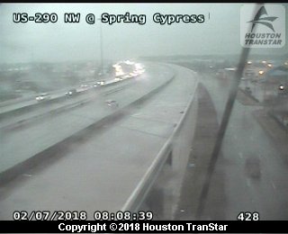
Big problems on US 290...first responders cannot reach accidents due to heavy ice.
-
djjordan
- Posts: 929
- Joined: Fri Feb 05, 2010 7:19 pm
- Location: Montgomery, Texas
- Contact:
HFD responding to some transformer issues in SE Houston ... this may be what you were seeing.Heat Miser wrote:Uh oh, saw some green flashes towards the Heritage Park part of Harris County just outside of Friendswood. Day off so I sure don't want my power to go out.
http://cbtcws.cityofhouston.gov/ActiveI ... dents.aspx
~~~When Thunder Roars Go Indoors~~~
~~~Turn Around Don't Drown~~~
~~~Run From The Water, Hide From The Wind~~~
~~~Turn Around Don't Drown~~~
~~~Run From The Water, Hide From The Wind~~~