

September: Weekend Rain Chances. 1-2 Inches Possible C/N TX
-
srainhoutx

- Site Admin

- Posts: 19700
- Joined: Tue Feb 02, 2010 2:32 pm
- Location: Maggie Valley, NC
- Contact:
Ingrid is nearing La Pesca at this hour and should be inland by 8-9 AM. Scattered showers and storms still look like a good bet this week as increased Gulf moisture and an inverted trough near Matagorda Bay enhances rain chances. By mid week another tropical disturbance currently located in the NW Caribbean willenter the Western Gulf increasing rain chances further as a cool front drops S from the Plains and stalls while PW's increase with a SE flow of the Gulf and the Upper Ridge weakens and slides E. Thursday into the weekend could be rather wet and stormy.
Carla/Alicia/Jerry(In The Eye)/Michelle/Charley/Ivan/Dennis/Katrina/Rita/Wilma/Humberto/Ike/Harvey
Member: National Weather Association
Facebook.com/Weather Infinity
Twitter @WeatherInfinity
Member: National Weather Association
Facebook.com/Weather Infinity
Twitter @WeatherInfinity
-
srainhoutx
- Site Admin
- Posts: 19700
- Joined: Tue Feb 02, 2010 2:32 pm
- Location: Maggie Valley, NC
- Contact:
Morning e-mail from Jeff:
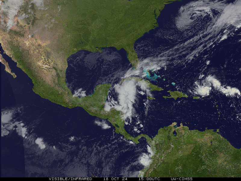
Eye of hurricane Ingrid is crossing the Mexican coastline at this time
Discussion:
Data from USAF missions continue to support Ingrid as a hurricane although the cloud pattern is disorganized and the center exposed on the SW side due to continued vertical shear. Radar data from Brownsville shows the center of the hurricane is currently crossing the coast with rainbands extending outward to its north across the lower TX coast.
Track/Intensity:
Ingrid has gained more latitude over the past 24 hours than expected, but the hurricane is moving toward the W or WNW and will be completely inland this morning. Expansion of the high pressure over TX for the next few days will keep the majority of both Ingrid’s and Manuel’s moisture to our south. Ingrid should dissipate fairly quickly in the next 24 hours.
Toward the end of the week, there are indications that the large moisture plume from both tropical systems over Mexico could begin to lift northward as a strong trough enters the central US. This could result in some heavy rainfall potential across portions of TX in the Thursday-Sunday time period.
Impacts:
Tides look to be peaking today around 1 ft above normal levels and both seas and tides should gradually fall through the mid week period.
Note:
Another area of disturbed weather has developed over the NW Caribbean Sea and is expected to move westward into the southern Gulf of Mexico and Bay of Campeche toward the middle part of the week. NHC currently gives this area a 20% chance of tropical cyclone development over the next 5 days.
Long Range Brownsville Radar:
Carla/Alicia/Jerry(In The Eye)/Michelle/Charley/Ivan/Dennis/Katrina/Rita/Wilma/Humberto/Ike/Harvey
Member: National Weather Association
Facebook.com/Weather Infinity
Twitter @WeatherInfinity
Member: National Weather Association
Facebook.com/Weather Infinity
Twitter @WeatherInfinity
-
djmike

- Posts: 1883
- Joined: Fri Jan 07, 2011 12:19 pm
- Location: BEAUMONT, TX
- Contact:
Also, are we still on track for decent precip towards the end of the week or has that vanished as things so often do around here?
Mike
Beaumont, TX
(IH-10 & College Street)
Beaumont, TX
(IH-10 & College Street)
-
djmike
- Posts: 1883
- Joined: Fri Jan 07, 2011 12:19 pm
- Location: BEAUMONT, TX
- Contact:
If all of this comes together, it will be a miracle!
From ABC 13 KTRK Houston: Travis Herzog
Ingrid has behaved as expected, moving into Mexico earlier today. Last week we talked about how even though we wouldn't take a direct hit from the storm, its moisture was likely to come our way later in the week. It now looks like not only will Ingrid's moisture move our way, but so will the moisture from Manuel and a new surge from the Caribbean. This could be just what the weather doctor ordered for our Texas-sized drought. Stay tuned.
- Attachments
-
- water vapor.png (217.98 KiB) Viewed 7353 times
Mike
Beaumont, TX
(IH-10 & College Street)
Beaumont, TX
(IH-10 & College Street)
-
SusieinLP

- Posts: 184
- Joined: Fri Feb 05, 2010 6:07 am
- Location: Galveston Bay
- Contact:
Well rain missed my yard again. Starting to take it personally now. Lol. However, those who got it, I'm happy for you. Hoping the end of week this area gets a soaking.
-
TexasBreeze
- Posts: 1029
- Joined: Sun Sep 26, 2010 4:46 pm
- Location: NW Houston, TX
- Contact:
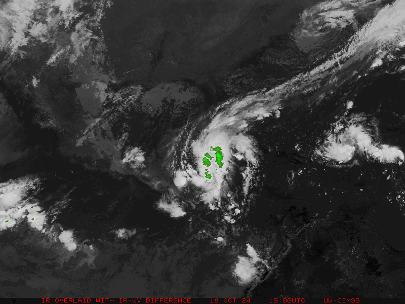
Invest 95l declared on Yucatan with 30% development by NHC. Where do the early models take it to? The answer isn't a shocker... 
-
srainhoutx
- Site Admin
- Posts: 19700
- Joined: Tue Feb 02, 2010 2:32 pm
- Location: Maggie Valley, NC
- Contact:
Not so sure that shear will abate enough to develop 95L much beyond a broad surface low in the monsoonal gyre, but with the lack of a competing EPAC storm this time and a rather complex upper air pattern of a Plains trough and frontal boundary stalling along or just inland of the NW/Central Gulf Coast may allow a surface feature to fester offshore of Tampico to La Pesca focusing heavy rains once again to Mexico/Coastal Texas/Louisiana and on E into Florida. This looks like a rainer more than anything.
Carla/Alicia/Jerry(In The Eye)/Michelle/Charley/Ivan/Dennis/Katrina/Rita/Wilma/Humberto/Ike/Harvey
Member: National Weather Association
Facebook.com/Weather Infinity
Twitter @WeatherInfinity
Member: National Weather Association
Facebook.com/Weather Infinity
Twitter @WeatherInfinity
-
unome
- Posts: 3062
- Joined: Fri Feb 12, 2010 6:11 pm
http://www.wunderground.com/blog/JeffMa ... rynum=2525
The waterlogged Gulf Coast of Mexico has yet another tropical rain-making system to worry about this week. An area of disturbed weather (Invest 95L) over the Yucatan Peninsula will emerge into the Southwestern Gulf of Mexico's Bay of Campeche on Wednesday. Belize radar and satellite loops show that 95L already has a pronounced spin and a respectable area of heavy thunderstorms. Wind shear is low and is expected to stay low over the next five days. There is some dry air over the Bay of Campeche, but I doubt this will be an impediment to development, given the low wind shear. NHC gave the disturbance 2-day development odds of 30% and 5-day odds of 50% in their 8 am EDT Tuesday Tropical Weather Outlook. The disturbance is likely to stay trapped in the Bay of Campeche and take a slow west-northwest path towards the same region of coast affected by Hurricane Ingrid. On Saturday, a cold front is expected to push southeastwards over the Gulf of Mexico, and moisture from 95L will likely stream northeastwards along the cold front over much of the U.S. Gulf Coast, bringing heavy rains on Saturday and Sunday. A non-tropical low pressure system could form along this front and move northeastwards into the Florida Gulf Coast, bringing heavy rains to the Southeast U.S. on Sunday and Monday.
Jeff Masters
-
wxman57

- Global Moderator

- Posts: 2621
- Joined: Thu Feb 04, 2010 5:34 am
- Location: Southwest Houston (Westbury)
- Contact:
Looks very similar to Ingrid about 30 hrs before Ingrid became a TD. I'd say good chance of development. Would track right along Ingrid's path to near Tampico Friday night or Saturday morning. Cold front this weekend doesn't look very strong, but the flow along the northern Gulf coast would prevent any track toward us.
-
srainhoutx
- Site Admin
- Posts: 19700
- Joined: Tue Feb 02, 2010 2:32 pm
- Location: Maggie Valley, NC
- Contact:
I'm not so sure the 12Z GFS has the upper air pattern correct. The GFS has a bias of overdoing troughs/frontal boundaries this time of year. I also don't think 95L will quickly get picked up and swept out NE. This is a far more difficult forecast than Ingrid was. This disturbance may not get inland for a while and if the front/trough are over done, then as that trough lifts N the upper air pattern may become a bit more condusive for development.
Carla/Alicia/Jerry(In The Eye)/Michelle/Charley/Ivan/Dennis/Katrina/Rita/Wilma/Humberto/Ike/Harvey
Member: National Weather Association
Facebook.com/Weather Infinity
Twitter @WeatherInfinity
Member: National Weather Association
Facebook.com/Weather Infinity
Twitter @WeatherInfinity
-
Rip76

- Posts: 2151
- Joined: Mon Feb 15, 2010 12:38 am
- Location: The Woodlands
- Contact:
I've just learned to jump right over WX's posts, because I know it's going to be depressing.

-
Rip76
- Posts: 2151
- Joined: Mon Feb 15, 2010 12:38 am
- Location: The Woodlands
- Contact:
Oh I know he is usually completely correct.Ed Mahmoud wrote:Rip76 wrote:I've just learned to jump right over WX's posts, because I know it's going to be depressing.
Maybe it is because WX57 is good at what he is doing, and the weather has been absolutely horribly boring and depressing, and nothing but drought and temperature forecasts, since December 2009.
Which makes it that much worse.
-
unome
- Posts: 3062
- Joined: Fri Feb 12, 2010 6:11 pm
NHC's 2pm TWO http://www.nhc.noaa.gov/text/refresh/MI ... WOAT.shtml
000
ABNT20 KNHC 171729
TWOAT
TROPICAL WEATHER OUTLOOK
NWS NATIONAL HURRICANE CENTER MIAMI FL
200 PM EDT TUE SEP 17 2013
FOR THE NORTH ATLANTIC...CARIBBEAN SEA AND THE GULF OF MEXICO...
THE NATIONAL HURRICANE CENTER IS ISSUING ADVISORIES ON TROPICAL STORM HUMBERTO...LOCATED OVER THE EASTERN ATLANTIC WELL SOUTHWEST OF THE AZORES.
AN AREA OF LOW PRESSURE LOCATED OVER BELIZE AND THE SOUTHERN YUCATAN PENINSULA IS ACCOMPANIED BY CLOUDINESS AND THUNDERSTORMS. THIS SYSTEM IS FORECAST TO MOVE SLOWLY TOWARD THE WEST-NORTHWEST AND EMERGE OVER THE BAY OF CAMPECHE ON WEDNESDAY. SURFACE PRESSURES ARE LOW IN THIS AREA...AND ENVIRONMENTAL CONDITIONS ARE EXPECTED TO BE FAVORABLE FOR DEVELOPMENT DURING THE NEXT DAY OR TWO. THIS LOW HAS A MEDIUM CHANCE...40 PERCENT...OF BECOMING A TROPICAL CYCLONE DURING THE NEXT 48 HOURS. ENVIRONMENTAL CONDITIONS SHOULD CONTINUE TO BE GENERALLY CONDUCIVE FOR SOME ADDITIONAL DEVELOPMENT DURING THE NEXT SEVERAL DAYS AS THE DISTURBANCE MOVES SLOWLY ACROSS THE SOUTHERN GULF OF MEXICO. THIS SYSTEM HAS A HIGH CHANCE...60 PERCENT...OF BECOMING A TROPICAL CYCLONE DURING THE NEXT 5 DAYS. REGARDLESS OF TROPICAL CYCLONE FORMATION...THIS DISTURBANCE WILL LIKELY SPREAD HEAVY RAINS OVER EASTERN MEXICO. THESE RAINS COULD CAUSE LIFE-THREATENING FLOODS AND MUD SLIDES OVER AREAS ALREADY IMPACTED BY THE TORRENTIAL RAINS ASSOCIATED WITH INGRID AND MANUEL.
&&
FIVE-DAY FORMATION PROBABILITIES ARE EXPERIMENTAL IN 2013. COMMENTS ON THE EXPERIMENTAL FORECASTS CAN BE PROVIDED AT...
http://WWW.NWS.NOAA.GOV/SURVEY/NWS-SURVEY.PHP?CODE=ETWO
$$
FORECASTER CANGIALOSI/AVILA
a piece of the discussion
A SURFACE TROUGH IS ALONG THE COAST OF THE NORTHWESTERN CORNER OF THE CARIBBEAN SEA...FROM THE YUCATAN PENINSULA...THROUGH THE GULF OF HONDURAS...INTO EL SALVADOR. A 1007 MB LOW PRESSURE CENTER IS ALONG THE TROUGH NEAR 18N88W. CONVECTIVE PRECIPITATION...SCATTERED TO NUMEROUS STRONG FROM HONDURAS AND GUATEMALA ALONG 15N TO 19N IN THE YUCATAN PENINSULA BETWEEN 86W AND 89W. NUMEROUS STRONG ALSO IN THE NORTHWESTERN CARIBBEAN SEA FROM 18N TO 20N BETWEEN 79W AND 84W. SCATTERED STRONG IS DEVELOPING FROM 14N TO 15N BETWEEN 81W AND 82W. THIS SYSTEM IS FORECAST TO MOVE SLOWLY TOWARD THE WEST-NORTHWEST AND EMERGE OVER THE BAY OF CAMPECHE ON WEDNESDAY. SURFACE PRESSURES ARE LOW IN THIS AREA...AND ENVIRONMENTAL CONDITIONS ARE EXPECTED TO BE FAVORABLE FOR DEVELOPMENT DURING THE NEXT DAY OR TWO. THIS LOW HAS A MEDIUM CHANCE OF BECOMING A TROPICAL CYCLONE DURING THE NEXT 48 HOURS. ENVIRONMENTAL CONDITIONS SHOULD CONTINUE TO BE GENERALLY CONDUCIVE FOR SOME ADDITIONAL DEVELOPMENT DURING THE NEXT SEVERAL DAYS AS THE DISTURBANCE MOVES SLOWLY ACROSS THE SOUTHERN GULF OF MEXICO. THIS SYSTEM HAS A HIGH CHANCE OF BECOMING A TROPICAL CYCLONE DURING THE NEXT 5 DAYS. THIS DISTURBANCE WILL LIKELY SPREAD HEAVY RAINS OVER EASTERN MEXICO. THESE RAINS MAY CAUSE LIFE-THREATENING FLOODS AND MUD SLIDES IN AREAS THAT ALREADY HAVE BEEN IMPACTED BY THE TORRENTIAL RAINS THAT HAVE BEEN ASSOCIATED WITH INGRID AND MANUEL... REGARDLESS OF TROPICAL CYCLONE FORMATION. THE 24-HOUR RAINFALL TOTAL IN INCHES FOR THE PERIOD ENDING AT 17/1200 UTC...ACCORDING TO THE PAN AMERICAN TEMPERATURE AND PRECIPITATION TABLES...MIATPTPAN...IS 0.07 IN MERIDA IN MEXICO.
-
Kludge

- Posts: 280
- Joined: Wed Feb 03, 2010 11:53 pm
- Location: Montgomery (Walden) TX
- Contact:
Well with little hope now of a TC coming to SE Texas, I'm actually hoping for an Ingrid path for this that keeps us on the NE or E side of wherever it ends up. Climo says that after our first real frontal passage, further tropical activity here becomes rare...so this may be our last real hope.Ed Mahmoud wrote: Normally a 10 day forecast, even a Euro forecast, can't be trusted, but a tropical storm hitting Louisiana with Texas on the breezy dry side, ala Tropical Storm Lee and the Bastrop fires, based on post 2009 weather, is completely plausible.
Highway 71 to Austin last weekend, miles of burnt trees from 2011 still.
-
Paul Robison
Questions:
1. What is HGX talking about?
THE PATTERN BECOMES COMPLICATED GOING INTO THE WEEKEND. INVEST AL95
MAY EASILY MOVE NORTHWEST INTO A MORE FAVORABLE...LESS-SHEARED
SW`ERN GULF ENVIRONMENT OVER THE NEXT COUPLE OF DAYS...AND THIS
WILL ADD ANOTHER ELEMENT TO THIS WEEKEND`S WEATHER SCENARIO. AS OF
NOW...A BROAD LOW OR TROPICAL SYSTEM MAY BECOME CAUGHT UP IN THE
NORTHEASTERLY STEERING FLOW OF THE APPROACHING NEAR-COASTAL MID-
LEVEL FRONT EARLY SATURDAY. THE INTERACTION BETWEEN THESE TWO
FEATURES...OR HOW NWP MODELING HANDLES THIS SITUATION...MAY BE
NOTEWORTHY IN THE COMING DAYS. SINCE THERE IS VIRTUALLY NO SKILL
AT THIS POINT...WILL BROADBRUSH LOW TO MODERATE CHANCE POPS OVER
THE SOUTHERN CWA/WATERS THROUGH THE WEEKEND. A MUCH DRIER AIR
MASS DESCENDS INTO EASTERN TEXAS EARLY NEXT WORK WEEK...ALLOWING
MANY NORTHERN RURAL SPOTS TO COOL INTO THE MEAN LOW TO MID 60S
MONDAY AND TUESDAY MORNINGS. 31
2. Should we look for any severe/powerful thunderstorms on Friday or just occasional heavy rains?
3. What is the possibility that this new invest (looks like soon to be Tropical Storm Jerry) will be pulled here by the aforementioned “cool” front? In other words – what is the probability that this system is pulled this way because of the frontal system? Seriously: I’ve never heard of a major storm forming in the Bay of Campeche and then recurving all the way across the Gulf to strike Louisiana or Florida. I think this thing's gonna be a problem! (See CMC model for what I mean).
-
SusieinLP
- Posts: 184
- Joined: Fri Feb 05, 2010 6:07 am
- Location: Galveston Bay
- Contact:
Didn't Opal form in BOC and hit Fl I late Sept?
-
srainhoutx
- Site Admin
- Posts: 19700
- Joined: Tue Feb 02, 2010 2:32 pm
- Location: Maggie Valley, NC
- Contact:
Opal crossed the Northern tip of the Yucatan on September 27th and quickly turned NE making landfall near Pensacola on October 4th 1995.SusieinLP wrote:Didn't Opal form in BOC and hit Fl I late Sept?
Carla/Alicia/Jerry(In The Eye)/Michelle/Charley/Ivan/Dennis/Katrina/Rita/Wilma/Humberto/Ike/Harvey
Member: National Weather Association
Facebook.com/Weather Infinity
Twitter @WeatherInfinity
Member: National Weather Association
Facebook.com/Weather Infinity
Twitter @WeatherInfinity
-
Paul Robison
S
BUT:
I still worry about the CMC's scenario of a hurricane being drawn into Houston/Galveston? Anyone think that a GOOD possibility?
Good thinking! See the Wikipedia entry for the track. It's a viable track, in my opinion.srainhoutx wrote:Opal crossed the Northern tip of the Yucatan on September 27th and quickly turned NE making landfall near Pensacola on October 4th 1995.SusieinLP wrote:Didn't Opal form in BOC and hit Fl I late Sept?
BUT:
I still worry about the CMC's scenario of a hurricane being drawn into Houston/Galveston? Anyone think that a GOOD possibility?
-
Rip76
- Posts: 2151
- Joined: Mon Feb 15, 2010 12:38 am
- Location: The Woodlands
- Contact:
I tell ya, if this Jerry was/is anything like Jerry from 1989, we could sure use it.
-
Ptarmigan

- Statistical Specialist

- Posts: 4536
- Joined: Wed Feb 03, 2010 7:20 pm
- Contact:
Jerry was one of the late season hurricanes. It shows that hurricanes can hit Texas late in the season.Rip76 wrote:I tell ya, if this Jerry was/is anything like Jerry from 1989, we could sure use it.