March - Slow Warming Trend With Rain Chance This Weekend?

General Weather Discussions and Analysis
User avatar
jasons2k
Posts: 5405
Joined: Thu Feb 04, 2010 12:54 pm
Location: Imperial Oaks
Contact:

wxman57 wrote:This cold weather is getting quite old. It's spring now, bring on some heat! Don't see anything in the latest GFS to indicate any significant warmth here, though.
I want some warmth too but I'll take the cold as long as it doesn't freeze and it keeps our chances for rain going a bit longer. The last thing I want to see is a flip to capping & upper 80's - 90's & no rain until the June sea breeze kicks-in.

I got .27" here overnight. Enough to keep things from wilting for another week or so....
User avatar
wxman57
Global Moderator
Global Moderator
Posts: 2621
Joined: Thu Feb 04, 2010 5:34 am
Location: Southwest Houston (Westbury)
Contact:

Got 0.89: in southwest Houston this morning.
unome
Posts: 3059
Joined: Fri Feb 12, 2010 6:11 pm

look at day 3, maybe some area-wide rain ?

http://www.spc.noaa.gov/products/outloo ... 0_prt.html

SPC AC 210727

DAY 3 CONVECTIVE OUTLOOK
NWS STORM PREDICTION CENTER NORMAN OK
0227 AM CDT THU MAR 21 2013

VALID 231200Z - 241200Z

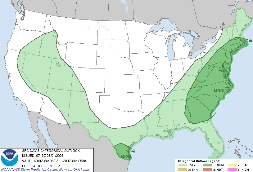
...THERE IS A SLGT RISK OF SVR TSTMS FROM E-CNTRL TX EASTWARD INTO
SRN GA AND N FL...

...SYNOPSIS...
A MID LEVEL SPEED MAX IS FORECAST TO MOVE FROM THE GREAT BASIN AND
APPROACH THE LOWER MS VALLEY BY DAYBREAK SUNDAY. AN ELONGATED AREA
OF LOW PRESSURE WILL DEVELOP EWD FROM THE SRN HIGH PLAINS TO THE
DEEP SOUTH AS A POWERFUL COLD FRONT SWEEPS SEWD FROM THE SRN PLAINS
INTO THE LOWER MS VALLEY. AN INCREASING NWD FLUX OF GULF OF MEXICO
MOISTURE INTO AREAS FROM TX EWD INTO GA WILL LIKELY LEAD TO AN
INCREASE IN THUNDERSTORM COVERAGE AND INTENSITY DURING THE DAY. THE
HIGHEST PROBABILITY OF MULTI-FACETED SEVERE WILL PROBABLY
CONCENTRATE INVOF AND S OF WHERE A WEST-EAST ORIENTED EFFECTIVE
BAROCLINIC ZONE BECOMES ESTABLISHED. STRONG TO SEVERE STORM ACTIVITY
IS EXPECTED TO PERSIST INTO THE OVERNIGHT...ESPECIALLY IN THE NERN
GULF STATES.

...E-CNTRL TX EWD INTO PARTS OF THE SERN STATES...
MODELS ARE CONVERGING TOWARDS A SCENARIO IN WHICH A BAROCLINIC ZONE
LIFTS NWD AS A WARM FRONT INTO SRN-CNTRL PORTIONS OF THE NRN GULF
COAST STATES. BEHIND THE ADVANCING BOUNDARY...RICHER MOISTURE
CHARACTERIZED BY 60S DEWPOINTS WILL CONTRIBUTE TO A DESTABILIZING
AIRMASS THROUGHOUT THE DAY. WHILE DEEP SHEAR WILL BE STRONG DURING
THE DAY AND FAVOR ORGANIZED STORMS IN THE FORM OF LINE
SEGMENTS/SUPERCELLS...THE MAIN THREATS WITH THIS ACTIVITY PRIOR TO
LATE AFTERNOON WILL SEEMINGLY BE LARGE HAIL/DMGG WINDS. AS LOW
LEVEL WINDS BEGIN TO STRENGTHEN BY LATE AFTERNOON/EARLY EVENING...AN
ISOLD TORNADO THREAT MAY SLOWLY INCREASE AS A LLJ INTENSIFIES TO 55
KTS AND BECOMES CENTERED OVER THE FL BIG BEND INTO SRN GA DURING THE
LATE NIGHT HOURS. FORECAST SOUNDINGS SHOW A CORRESPONDING INCREASE
IN THE SIZE OF LOW LEVEL HODOGRAPHS OVER THE NERN GULF COAST STATES
INTO GA DURING THIS TIMEFRAME. AS FORCING CONTINUES TO INCREASE
DURING THE PERIOD...THIS SHOULD PROMOTE UPSCALE GROWTH INTO ONE OR
MORE BANDS OF STORMS. CONCURRENTLY...THE PROPENSITY FOR UPDRAFT
ROTATION WILL LIKEWISE INCREASE...ESPECIALLY DURING THE LATTER HALF
OF THE PERIOD. AS SUCH...DMGG WIND GUSTS AND A FEW TORNADOES WILL
LIKELY BECOME THE MAIN THREATS WITH THE OVERNIGHT ACTIVITY.

ONCE DETAILS REGARDING THE POLEWARD POSITION OF THE EFFECTIVE
BAROCLINIC ZONE --TIED IN PART TO CONVECTIVE ACTIVITY-- BECOME LESS
AMBIGUOUS...A HIGHER PROBABILITY AREA COULD BE WARRANTED FROM SRN
MS/AL EWD INTO SRN GA/N FL.

..SMITH.. 03/21/2013

NOTE: THE NEXT DAY 3 OUTLOOK IS SCHEDULED BY 0730Z
CURRENT UTC TIME: 0913Z (4:13AM), RELOAD THIS PAGE TO UPDATE THE TIME

Image
Image
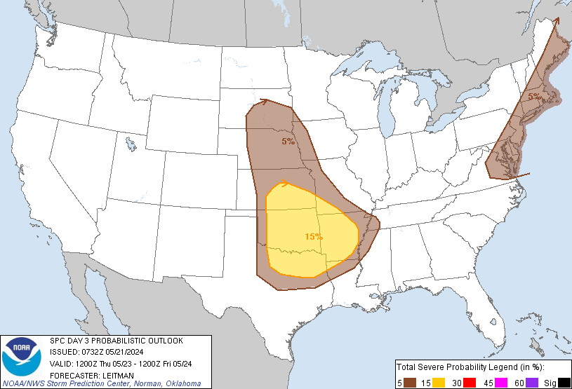
Probability of severe weather within 25 miles of a point.
Hatched Area: 10% or greater probability of significant severe within 25 miles of a point.
jeff
Pro Met
Pro Met
Posts: 328
Joined: Wed Feb 10, 2010 5:19 pm
Contact:

The boys in Norman seem to think the cap erodes and "boom". Pattern of late supports the cap holding especially under more clouds and onshore flow. Think most of the action will be well east of SE TX. Although I would watch the area bounded by Rockport to Beeville to Vcitoria as this is where the dry line and seabreeze may collide and enough heating may erode the capping enough to allow a severe cell to pop. There also appears to be some weak energy riding NE in the SW flow aloft that could help generate activity in this area. Another Spring so common of the past so many where severe weather and rainfall itself is hard to come by. Global patterns continue to support southern plains drought and surpression of our spring severe weather season.
unome
Posts: 3059
Joined: Fri Feb 12, 2010 6:11 pm

QPF for Day 3 doesn't show much for SE TX

Image

from CPC http://www.cpc.ncep.noaa.gov

Daily Climate Headlines

March 20, 2013

(Available Monday-Friday)

Headlines

The week 2 circulation (500 hPa) forecast for week 2 calls a ridge over the Rockies, a trough over the Gulf of Alaska and also just off the east coast of CONUS. The surface forecast calls for colder than normal temperatures are likely for Alaska, western sections of the Pacific Coast States, and from the Mississippi Valley eastward. Above-median precipitation is likely for southwestern sections of Oregon and for California and the Southeast. Below-median precipitation is likely for Texas, the Missouri Valley, the central and upper Mississippi Valley the Great Lakes, the Middle Atlantic Coast States, New England, and southwestern Alaska. --- Ed O’Lenic

Impacts

HEAVY RAIN FOR PARTS OF THE SOUTHEAST, FRI-SUN, MARCH 22-24.
HEAVY PRECIPITATION FOR PARTS OF KANSAS, ARKANSAS, OKLAHOMA, AND ARKANSAS, THU, MARCH 21.
MUCH BELOW NORMAL TEMPERATURES FOR PARTS OF THE NORTHERN PLAINS, THU-WED, MARCH 21-27.
MUCH BELOW NORMAL TEMPERATURES FOR PARTS OF MINNESOTA, WISCONSIN, MICHIGAN, AND IOWA, THU-FRI, MARCH 21-22.
LOCALLY HEAVY SNOW FOR PARTS OF IDAHO AND WASHINGTON, THU, MARCH 21.
SIGNIFICANT WAVES FOR PARTS OF THE PACIFIC NORTHWEST COAST, THU, MARCH 21.
HIGH WINDS FOR PARTS OF EASTERN NEW MEXICO, THU, MARCH 21.
RIVER FLOODING ACROSS PARTS OF THE MIDDLE MISSISSIPPI VALLEY.
MUCH BELOW NORMAL TEMPERATURES FOR PARTS OF EASTERN ALASKA AND THE ALASKAN PANHANDLE, FRI, MARCH 22.
ENHANCED WILDFIRE RISK FOR PARTS OF NEW MEXICO AND TEXAS, THU, MARCH 21.
SEVERE DROUGHT FOR PARTS OF THE SOUTHEAST, UPPER MISSISSIPPI VALLEY, RIO GRANDE VALLEY, GREAT PLAINS, ROCKIES, SOUTHWEST, GREAT BASIN, AND HAWAII.

looking more like another dry summer :(

Image
Image
Image
Image
unome
Posts: 3059
Joined: Fri Feb 12, 2010 6:11 pm

though the link's in my hurricane-watching list of favs, it's always fun to keep an eye on global tpw, to see the whole picture

from CIMSS http://tropic.ssec.wisc.edu/real-time/m ... /main.html

Image

Image
unome
Posts: 3059
Joined: Fri Feb 12, 2010 6:11 pm

from HGX' am discussion

.PREV DISCUSSION... /ISSUED 411 AM CDT THU MAR 21 2013/

DISCUSSION...
WITH THE SURFACE RIDGE MOVING EAST OF THE STATE THIS MORNING...
ONSHORE WINDS WILL RETURN GULF MOISTURE AND WARMER TEMPERATURES
ACROSS SE TX TODAY. A TIGHT PRESSURE GRADIENT WILL DEVELOP AND
CAUSE BREEZY CONDITIONS TO DEVELOP DURING THE LATE MORNING AND
THROUGH THE AFTERNOON.

A SHORTWAVE TROUGH WILL MOVE OVERHEAD TONIGHT AND FRIDAY AND MAY
HELP TO GENERATE SOME ISOLATED SHOWERS. HOWEVER...A DECENT CAP
WILL DEVELOP ON FRIDAY AND LINGER INTO EARLY SATURDAY. THIS SHOULD
KEEP A LID ON SHOWER OR THUNDERSTORM DEVELOPMENT.

ON SATURDAY AS AN UPPER LEVEL TROUGH DEEPENS OVER THE ROCKIES AND
SOUTHERN PLAINS...A STRONG SHORTWAVE TROUGH WILL PUSH INTO TEXAS.
COUPLED WITH THIS WILL BE A FRONTAL BOUNDARY SETTING UP ALONG OR
JUST TO THE SOUTH OF THE RED RIVER VALLEY. THE GFS ERODES THE CAP
OVER SE TX SATURDAY AFTERNOON...ALTHOUGH THE MODEL MAY BE A BIT
TOO OPTIMISTIC IN DOING SO. BECAUSE OF THIS SETUP...EXPECT RAIN
AND THUNDER CHANCES TO INCREASE ON SATURDAY WITH THE BEST CHANCES
OVER THE NORTHERN COUNTIES NEAREST TO THE FRONTAL BOUNDARY. THE
MODELS DIFFER ON THE FRONTAL TIMING...WITH THE GFS AND CANADIAN
PUSHING THE FRONT THROUGH BY SATURDAY EVENING AND THE ECMWF EARLY
SUNDAY MORNING. GIVEN THE FLOW PATTERN ALOFT...THE NAM12 MAY HAVE
THE RIGHT IDEA IN PUSHING A DRY LINE IN FROM THE WEST SATURDAY
AFTERNOON WITH THE COLD FRONT THEN MOVING ACROSS THE AREA FROM
THE NORTH SATURDAY EVENING. AGREE WITH THE DAY 3 SPC OUTLOOK AS
THE BUFR SOUNDING FORECASTS DO INDICATE A POTENTIAL FOR AT LEAST
ISOLATED STRONG OR SEVERE STORMS MAINLY TOWARD THE FRONTAL
BOUNDARY.
FOR NOW...WILL GO WITH A 30 PERCENT SOUTH AND 40 PERCENT
NORTH FOR SHOWERS AND THUNDERSTORMS ON SATURDAY AND A 20 PERCENT
IN THE NORTHEASTERN COUNTIES SATURDAY EVENING. WILL DISCUSS ANY
SEVERE THUNDERSTORM CHANCES IN THE HAZARDOUS WEATHER OUTLOOK.

WITH THE FRONTAL PASSAGE...THE FIRST HALF OF NEXT WEEK WILL BE
DRY. EXPECT A WARMING TREND OVER THE MIDDLE PART OF THE WEEK AS
THE WINDS GRADUALLY GO FROM NORTHEAST TO ONSHORE.
User avatar
Kludge
Posts: 254
Joined: Wed Feb 03, 2010 11:53 pm
Location: Bedias, Texas
Contact:

jeff wrote:The boys in Norman seem to think the cap erodes and "boom". Pattern of late supports the cap holding especially under more clouds and onshore flow. Think most of the action will be well east of SE TX. Although I would watch the area bounded by Rockport to Beeville to Vcitoria as this is where the dry line and seabreeze may collide and enough heating may erode the capping enough to allow a severe cell to pop. There also appears to be some weak energy riding NE in the SW flow aloft that could help generate activity in this area. Another Spring so common of the past so many where severe weather and rainfall itself is hard to come by. Global patterns continue to support southern plains drought and surpression of our spring severe weather season.
That does it. I hate caps, and will never wear one again. :twisted: :lol:

Image

Uploaded with ImageShack.us
User avatar
jasons2k
Posts: 5405
Joined: Thu Feb 04, 2010 12:54 pm
Location: Imperial Oaks
Contact:

jeff wrote:Another Spring so common of the past so many where severe weather and rainfall itself is hard to come by. Global patterns continue to support southern plains drought and surpression of our spring severe weather season.
Jeff:

Could you (or someone) elaborate on what global patterns are keeping us in drought-mode and how long this will continue??

I moved here in 2005 and since then, we've had one, maybe two so-called 'normal' spring storm seasons. Year after year, as soon as it begins to warm-up, the cap takes over and we're left dry as a cactus while points to the north seem to carry-on as usual. When will it ever stop?

I've noticed there are a lot of trees that technically survived the 2011 drought but they're not in good health; they are just barely limping along until we get a consistent pattern of more rainfall. I'm getting quite concerned that this summer may be another depressing one (and summer, usually, is my favorite season). Between Rita, Ike, & the 2011 drought, my neighborhood is losing its entire tree canopy in places. I looked at some pictures from 2005 a few days ago and I had forgotten how thick and lush it was pre-Rita compared to now. I was shocked -- It's getting to the point of complete and total ridiculousness.

I know "mother nature" is imaginary but if she were a real person, I'd have a few - actually many - choice words for her!
mckinne63
Posts: 553
Joined: Fri Jul 08, 2011 4:50 pm
Location: Stafford, TX
Contact:

Getting some sprinkling of rain in Stafford, any change of something more?
Paul Robison

Sorry folks. GFS 18Z run still puts Houston in the green instead of the red or blue as far as rain goes. North and east of town still areas to watch, if I read it right. April 4th low pressure looks a little more impressive to me, though. Any comments?
User avatar
srainhoutx
Site Admin
Site Admin
Posts: 19616
Joined: Tue Feb 02, 2010 2:32 pm
Location: Maggie Valley, NC
Contact:

I'm getting a bit concerned that areas away from the urban heat island of Metro Houston may see overnight temps at or just below freezing Monday and Tuesday mornings. The GFS is coming in a bit 'colder', so we'll need to keep a close eye on that development for those that have done their Spring planting.
Carla/Alicia/Jerry(In The Eye)/Michelle/Charley/Ivan/Dennis/Katrina/Rita/Wilma/Humberto/Ike/Harvey

Member: National Weather Association
Facebook.com/Weather Infinity
Twitter @WeatherInfinity
User avatar
wxman57
Global Moderator
Global Moderator
Posts: 2621
Joined: Thu Feb 04, 2010 5:34 am
Location: Southwest Houston (Westbury)
Contact:

I think Conroe/Huntsville areas could see a low near freezing Mon/Tue. Most of Houston should be in the mid to upper 30s. I'll be in New Orleans for the National Hurricane Conference next week.
Cromagnum
Posts: 2630
Joined: Thu Feb 03, 2011 10:42 pm
Contact:

Surprise, surprise. Another storm system coming in, and another cap sitting right on top of the area to completely shut it down. We've played this record so many times that it has lost all its texture.
Texas Pirate

Oh why did I plant my garden today if we're going into freeze?
I think the Bay area should be a bit "warmer"

And just for the record, I do believe we're going into another drought summer
with no rain with a name on it..... :(
Paul Robison

Question:

NOAA believes Houston area will get "primarily rain" with a mentionable chance for a discrete strong to severe thunderstorm affecting areas GENERALLY north of a Brenham to Huntsville to Corrigan line." I assume these locations to be north or northeast of our area (that will) get the (severe) thunderstorms. So could someone tell explain David Paul's futurecast showing Houston to be right in the line of fire of these severe storms, when (apparently) NOAA doesn't seem to agree?
Consider this weather.gov/houston graphic:


Image

and:

Image

and:

Image
As you can see, the severe weather threat will shift more to the east on Saturday. A cap of warm air aloft will limit thunderstorm activity over much of SE Texas. Most of Houston seems to fall under this cap of warm air. Am I wrong?
User avatar
wxman666
Posts: 519
Joined: Thu Jul 22, 2010 9:02 pm
Location: Cypress, TX
Contact:

Interestingly....SPC adds a small sliver of the Edwards Plateau to the slight risk for early Sat for hail. Pic and text below.

Image

...EDWARDS PLATEAU...HILL COUNTRY OF TX...
DIURNALLY-DRIVEN CONVECTION ALONG THE TRAILING PORTION OF A
QUASI-STATIONARY FRONT IN CNTRL TX WILL LIKELY CONTINUE TO WEAKEN IN
THE NEAR-TERM. HOWEVER...LOW-LEVEL SELYS WILL INCREASE LATE EVENING
INTO THE OVERNIGHT IN RESPONSE TO THE DIGGING OF A SHORTWAVE IMPULSE
FROM THE ERN GREAT BASIN TO THE CO ROCKIES. THIS WILL YIELD RAPID
MOISTENING FROM S TX AND RESULT IN MODERATE ELEVATED BUOYANCY GIVEN
VERY STEEP MID-LEVEL LAPSE RATES. AS LOW-LEVEL CONVERGENCE
STRENGTHENS EARLY SAT...OPERATIONAL AND CONVECTION-ALLOWING MODEL
GUIDANCE ARE FAIRLY CONSISTENT IN SUGGESTING CONVECTIVE DEVELOPMENT
BETWEEN 09-12Z. THIS SETUP MAY YIELD AN ELEVATED SUPERCELL OR TWO
WITH A RISK FOR LARGE HAIL /POSSIBLY SIGNIFICANT/. HOWEVER...GIVEN
MODERATE UNCERTAINTY OVER WHERE STORMS WILL FORM ALONG WITH TIMING
AT THE END OF THE PERIOD...WILL REFRAIN FROM INTRODUCING SIGNIFICANT
HAIL PROBABILITIES.
Ready for severe weather season!!
Paul Robison

NWS DISCUSSION... /ISSUED 455 AM CDT FRI MAR 22 2013/


OVERNIGHT INTO SATURDAY MORNING THE PROGRESS OF THE (COLD) FRONT WILL BE
THE MAIN ISSUE. NAM BRINGS THE FRONT ALMOST TO HOUSTON THROUGH THE
OVERNIGHT HOURS. GFS IS LESS AGGRESSIVE. THIS MEANS THERE COULD
BE AS MUCH AS 10 TO 15 DEGREES IN FORECAST ERROR FOR MIN TEMPS
DEPENDING ON WHERE THE FRONT STALLS. HEDGED MIN TEMPS CLOSER TO
SCENARIO OF FRONT PUSHING TOWARDS HOUSTON SO FORECAST MINS ARE
COOLER THAN GFS BUT NOT QUITE AS COOL AS NAM. THINK THE FRONT
STALLING CLOSE TO A BRENHAM...HUNTSVILLE...LUFKIN LINE MORE LIKELY
OR JUST SOUTH OF GFS POSITION BUT HAVE TO SAY NAM HAS BEEN
CONSISTENTLY PUSHING THE FRONT FARTHER SOUTH.

FORECAST FOR SATURDAY STILL A CHALLENGE AS WELL. FRONTAL BOUNDARY
SHOULD PUSH BACK NORTH AS A WARM FRONT WILL THE APPROACH OF A
STRONG SHORT WAVE COMING OUT OF THE ROCKIES AND INTO THE PLAINS
SATURDAY EVENING. THIS SHOULD ALLOW FOR MOIST/UNSTABLE WARM SECTOR
TO DEVELOP OVER SE TX. AGAIN THE CAP WILL BE THE MAIN PROBLEM FOR
THUNDERSTORM DEVELOPMENT BUT IF IT WERE TO BREAK THINK SEVERE
STORMS WILL BE POSSIBLE.
HOWEVER THE TIME FRAME FOR SEVERE STORMS
WILL BE SMALL. BOUNDARY LAYER AND 850MB WINDS VEER AROUND QUICKLY
TO THE WEST LATE SAT AFTERNOON AS DRY SLOT MOVES INTO THE REGION.
SO THINK FROM ABOUT 19Z TO ABOUT 23Z THERE MAY BE A SMALL CHANCE
OF A FEW SEVERE STORMS BUT LIKELY EAST OF I-45. SPC HAS MOVED
SLIGHT RISK TO EAST OF THE AREA. THIS SEEMS QUITE REASONABLE GIVEN
THE CAP AND DRY SLOT WORKING INTO THE AREA. ALSO BACKED OFF ON
POPS TO 30/40 PERCENT WITH THE CAP IN PLACE AND DRY SLOT WORKING
INTO THE AREA. THERE STILL MAY BE SHOWERS UNDER THE CAP BUT COULD
STILL GET SEVERAL STORMS TO DEVELOP IF IT BREAKS.


C.Y.A.
Post Reply
  • Information