
Strong onshore flow continues to pump low level moisture into the area this morning. Low level stratus deck in not as thick and higher based than recent mornings, and would expect this deck to break and scatter by late morning as opposed to early afternoon.
Main forecast concern focuses around convective chances on Wednesday and winds this afternoon. Already getting 30-35mph gust over the coastal bend locations this morning and with the onset of heating and deeper mixing of the low level jet above the surface expecting some healthy winds today. Strongest winds will be found over the Matagorda Bay area southward toward CRP.
Next storm system will arrive into the plains Wednesday with strong surface low pressure lifting toward the Great Lakes. Main dynamics will pass well north of SE TX, but southern edge of colder mid level temperatures and lift will sweep across at least the northern half of SE TX late Wednesday. Impressive capping noted on CRP and LCH soundings this morning will have to be weakened and breached to allow thunderstorms to develop. Latest NAM guidance completely erodes this feature by Wednesday afternoon while the GFS maintains at least some degree of inhibition. Cold front (and a fairly strong one for early April) will arrive into SE TX early Wed afternoon and reach the coast toward early to mid evening. This timing supports the best lift will coincide with the strongest heating and best opportunity to break the capping inversion. Models are not overly aggressive with rain chances or convection, but instead show a broken line of showers/thunderstorms. Recent events have failed to break the capping inversion as the models have been under-forecasting its intensity of late. I am tempted to side with the low rain chances and stronger inversion, however SPC has outlooked a good part of the area for a slight risk of severe thunderstorms and long period of moist southerly flow off the Gulf has finally returned some decent quality moisture to the area. Feel a few parcels will breach the inversion and develop into strong/severe thunderstorms Wednesday afternoon/evening. Best chances will be over our NE counties with the lowest chances around Matagorda Bay where the cap will be strongest. Will need to closely watch trend early Wednesday for additional defining of the severe weather threat…it is one of those situations where you could get a good round of storms or nothing at all.
Post frontal air mass is chilly for early April and will see lows back into the 40’s for many locations Thursday and Friday mornings with highs in the upper 60’s to lower 70’s. Return flow off the Gulf begins by Saturday ahead of a fairly strong looking system over the SW US early next week. W TX dry line looks to form up with active thunderstorm chances Mon-Tues of next week.
April Weather Discussion.
-
srainhoutx

- Site Admin

- Posts: 19616
- Joined: Tue Feb 02, 2010 2:32 pm
- Location: Maggie Valley, NC
- Contact:
Morning e-mail from Jeff...could get interesting after all...and looking at guidance from overnight, next week may offer better chances of severe weather. We shall see.
Carla/Alicia/Jerry(In The Eye)/Michelle/Charley/Ivan/Dennis/Katrina/Rita/Wilma/Humberto/Ike/Harvey
Member: National Weather Association
Facebook.com/Weather Infinity
Twitter @WeatherInfinity
Member: National Weather Association
Facebook.com/Weather Infinity
Twitter @WeatherInfinity

NWS not impressed either:
"TOMORROW`S FROPA LOOKS TO BEHAVE AS THE LAST FEW HAVE AND COME THROUGH WITH LITTLE TO NO FANFARE."
"TOMORROW`S FROPA LOOKS TO BEHAVE AS THE LAST FEW HAVE AND COME THROUGH WITH LITTLE TO NO FANFARE."
That Darn Cap!
Once again it appears SE TX will be on the southern edge of the storms. SPC writes:
"SVR THREAT BECOMES MORE CONDITIONAL WITH SWWD EXTENT OVER
MIDDLE-LOWER TX COASTAL PLAIN AND LOWER RIO GRANDE VALLEY...WHERE
FRONTAL FORCING WILL BE COUNTERBALANCED TO SOME EXTENT BY STG
CAPPING. FCST DEEP-LAYER SHEAR...I.E. 40-45 KT EFFECTIVE
VALUES...AND LARGE PREFRONTAL MLCAPE IN 2000-3000 J/KG
RANGE...INDICATE POTENTIAL FOR SVR GIVEN SUSTAINED CONVECTION."
Probably 50/50 chances for severe weather in the Houston metro area.
-
sleetstorm
- Posts: 651
- Joined: Thu Feb 04, 2010 12:33 pm
- Contact:
I realize that this only a supposition for now, but the cap could very easily be eroded away tomorrow faster than what we think. Just my thoughts.
And you say that because of why?sleetstorm wrote:I realize that this only a supposition for now, but the cap could very easily be eroded away tomorrow faster than what we think. Just my thoughts.
-
sleetstorm
- Posts: 651
- Joined: Thu Feb 04, 2010 12:33 pm
- Contact:
I just think that it could that it might if all of the ingredients come together just right at the right time, wxdata. I am not being wishful or wishcasting, I just think that we could go from a beautiful, mostly sunny day to all of a sudden, where did this Bow Echo thunderstorm or Supercell Thunderstorm come from. There have been days like that in the past during the season of spring here in southeast Texas & a majority of us on this forum know that all too well. I am not a Professional Meteorologist, I just possess a certain degree of knowledge from watching the Weather Channel and KHOU's meteorologists to know some of what I am talking about.wxdata wrote:And you say that because of why?sleetstorm wrote:I realize that this only a supposition for now, but the cap could very easily be eroded away tomorrow faster than what we think. Just my thoughts.
I'm not every trying to back you into any corner when I ask. I thought you may have seen something on another model that I've missed, especially with the 18z NAM showing mostly no cap by 6pm Wednesday.
18z NAM severe indicies continue to show a mixed bag. Perhaps a bit more unstable than the 12z
18z NAM severe indicies continue to show a mixed bag. Perhaps a bit more unstable than the 12z

We have indeed had surprise local severe events in the past however, tomorrow does not look like that will be the case at all. We will have lots of low clouds around, leftover from tonight along with winds veering around to the southwest at the surface and aloft (not allowing for the cap to erode much at all during the day and limiting instability) along with the low level jet decreasing as the front approaches, both negating factors if you want long lived strong to severe thunderstorm activity around the Houston area. Moisture levels will be rather high along with some frontal forcing which will likely produce scattered showers and some isolated storms around during the afternoon and evening but nothing severe down here...maybe up north and east where the stronger upper level dynamics could help cancel out the negative factors.sleetstorm wrote:I am not being wishful or wishcasting, I just think that we could go from a beautiful, mostly sunny day to all of a sudden, where did this Bow Echo thunderstorm or Supercell Thunderstorm come from.
On past surprise events if I remember correctly, other local effects such as the sea breeze front/outflow boundary interactions and or extreme daytime heating helped overcome the negative factors and the severe weather which occurred was only across isolated locations.
-
weatherguy425
- Pro Met

- Posts: 830
- Joined: Wed Feb 03, 2010 7:45 pm
- Location: Atlanta, Georgia
- Contact:
Some really explosive storms up in OK right now, some showers also now in central texas.
0z NAM a bit more unstable; a few severe indicies moving higher, others still marginal. Readings are for noon Wednesday. Small window for supercells late afternoon.
-
sleetstorm
- Posts: 651
- Joined: Thu Feb 04, 2010 12:33 pm
- Contact:
You did not back me up into a corner, metaphorically speaking, when you inquired where I may have seen something on another model that you might have missed on the computer models. I was simply divulging all of you, including svrwx0305, what my thoughts were and that was all. Rest at ease my friend.wxdata wrote:I'm not every trying to back you into any corner when I ask. I thought you may have seen something on another model that I've missed, especially with the 18z NAM showing mostly no cap by 6pm Wednesday.
18z NAM severe indicies continue to show a mixed bag. Perhaps a bit more unstable than the 12z


That Cockroach Cap! Someone get a bunch of cans of RAID to spray it on the Cockroach Cap, preferably the powerful kind.wxdata wrote:That Darn Cap!
Once again it appears SE TX will be on the southern edge of the storms. SPC writes:
"SVR THREAT BECOMES MORE CONDITIONAL WITH SWWD EXTENT OVER
MIDDLE-LOWER TX COASTAL PLAIN AND LOWER RIO GRANDE VALLEY...WHERE
FRONTAL FORCING WILL BE COUNTERBALANCED TO SOME EXTENT BY STG
CAPPING. FCST DEEP-LAYER SHEAR...I.E. 40-45 KT EFFECTIVE
VALUES...AND LARGE PREFRONTAL MLCAPE IN 2000-3000 J/KG
RANGE...INDICATE POTENTIAL FOR SVR GIVEN SUSTAINED CONVECTION."
Probably 50/50 chances for severe weather in the Houston metro area.
-
sleetstorm
- Posts: 651
- Joined: Thu Feb 04, 2010 12:33 pm
- Contact:
Okay, I am not attacking anyone with words, it just seems as though, from what I have read from some of your posts, such as svrwx0305, we will not be receiving any severe thunderstorms at all tomorrow, however you wxdata said that southeast Texas has a small opportunity to get supercell thunderstorms.wxdata wrote:0z NAM a bit more unstable; a few severe indicies moving higher, others still marginal. Readings are for noon Wednesday. Small window for supercells late afternoon.
-
sleetstorm
- Posts: 651
- Joined: Thu Feb 04, 2010 12:33 pm
- Contact:
Or, am I misunderstanding something?
I think there is a small window for severe weather for somewhere in SE TX, although GFS still shows very marginal. The SPC early morning update still has SE TX under a slight risk.
-
srainhoutx
- Site Admin
- Posts: 19616
- Joined: Tue Feb 02, 2010 2:32 pm
- Location: Maggie Valley, NC
- Contact:
I suspect the cap will hold this afternoon. Nothing really to break it. Maybe some elevated rumbles behind the front. The main story will likely be the cooler temps. That will be a big change from the humid/warm temps we have been seeing as of late. I noticed that Austin / San Antonio are mentioning 40's to the mid and upper 30's for tomorrow night into Friday for lows. That is a fairly stout front for this time of year. SPC Update should be out around 7:30 AM and we will see if they keep us in the Slight Risk area. Ed has shown that some storms are firing in W TX. Perhaps the guidance may be on to something eroding the cap before the front after all.
Carla/Alicia/Jerry(In The Eye)/Michelle/Charley/Ivan/Dennis/Katrina/Rita/Wilma/Humberto/Ike/Harvey
Member: National Weather Association
Facebook.com/Weather Infinity
Twitter @WeatherInfinity
Member: National Weather Association
Facebook.com/Weather Infinity
Twitter @WeatherInfinity
-
srainhoutx
- Site Admin
- Posts: 19616
- Joined: Tue Feb 02, 2010 2:32 pm
- Location: Maggie Valley, NC
- Contact:
SPC keeps us in a Slight Risk...
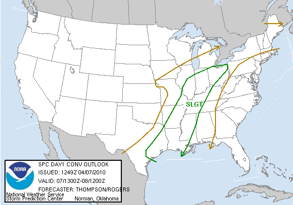
DAY 1 CONVECTIVE OUTLOOK
NWS STORM PREDICTION CENTER NORMAN OK
0749 AM CDT WED APR 07 2010
VALID 071300Z - 081200Z
...THERE IS A SLGT RISK OF SVR TSTMS THIS AFTERNOON INTO TONIGHT
FROM THE OH VALLEY TO THE LOWER MS VALLEY AND NW GULF COAST...
...SYNOPSIS...
A SURFACE CYCLONE IN NE MO/W CENTRAL IL AS OF 11Z WILL MOVE ENEWD TO
THE LOWER GREAT LAKES BY TONIGHT...AS A POSITIVE TILT MIDLEVEL
TROUGH PROGRESSES EWD FROM THE CENTRAL PLAINS TO THE MID MS VALLEY.
TRAILING THE CYCLONE...A COLD FRONT WILL MOVE SEWD ACROSS IL/MO/AR/E
TX BY LATE AFTERNOON...AND CONTINUE EWD/SEWD TO OH/KY/TN AND THE
LOWER MS VALLEY BY EARLY THURSDAY. THIS COLD FRONT WILL SERVE AS
THE PRIMARY FOCUS FOR STRONG/SEVERE THUNDERSTORM DEVELOPMENT THROUGH
THE PERIOD.
...OH/MS VALLEY REGION THROUGH TONIGHT...
CONVECTION INVOF THE COLD FRONT HAS LARGELY DISSIPATED...LEAVING
SCATTERED DEBRIS CLOUDS FROM AR NEWD TO THE OH VALLEY. BREAKS IN
THE CLOUDS WILL ALLOW DAYTIME HEATING AND ASSOCIATED LOW-LEVEL
DESTABILIZATION. ALSO...LOW-LEVEL MOISTURE DEPTH/QUALITY HAS
IMPROVED SINCE YESTERDAY ACROSS E TX/LA/AR WHERE BOUNDARY LAYER
DEWPOINTS RANGE FROM THE LOW-MID 60S. THIS MOISTURE WILL SPREAD
NEWD IN ADVANCE OF THE COLD FRONT TODAY...WITH DEWPOINTS EXPECTED TO
INCREASE INTO THE LOW 60S BY AFTERNOON AS FAR NE AS IL/INDIANA.
STILL...THE DEGREE OF INSTABILITY WILL BE TEMPERED SOMEWHAT BY
WEAKER MIDLEVEL LAPSE RATES COMPARED TO PREVIOUS DAYS. THE NET
RESULT SHOULD BE PRE-FRONTAL CORRIDOR OF 750-1250 MLCAPE BY MID
AFTERNOON.
THUNDERSTORMS WILL INCREASE IN COVERAGE/INTENSITY RATHER QUICKLY BY
EARLY-MID AFTERNOON AS LINGERING CONVECTIVE INHIBITION IS REMOVED IN
THE BELT OF ASCENT ALONG THE FRONT. WIND PROFILES ARE EXPECTED TO
BECOME MORE UNIDIRECTIONAL WITH TIME...AND LOW-LEVEL FLOW/SHEAR WILL
ALSO BECOME RATHER MODEST IN THE WARM SECTOR BY AFTERNOON. THE
LARGELY FRONT-PARALLEL SHEAR VECTORS AND FLOW ALOFT WILL PROMOTE
RATHER QUICK EVOLUTION INTO LINE SEGMENTS...THOUGH DEEP-LAYER
VERTICAL SHEAR/INSTABILITY WILL BE SUFFICIENT FOR EMBEDDED
SUPERCELL/BOW STRUCTURES WHICH WILL LOCALLY ENHANCE THE SEVERE STORM
THREAT. GIVEN THE MODEST INSTABILITY AND EXPECTED STORM
MODE/EVOLUTION...THE MOST COMMON SEVERE STORM THREAT SHOULD BE
DAMAGING WINDS...FOLLOWED BY MARGINALLY SEVERE HAIL AND POSSIBLY A
TORNADO OR TWO.
THE SEVERE STORM THREAT WILL INCREASE FROM 18-21Z...LIKELY PEAK IN
THE 21-00Z TIME FRAME...AND THEN SLOWLY DECREASE OVERNIGHT FROM N TO
S...WITH THE THREAT LINGERING THE LONGEST INTO THE MID SOUTH.
..THOMPSON/ROGERS.. 04/07/2010
Carla/Alicia/Jerry(In The Eye)/Michelle/Charley/Ivan/Dennis/Katrina/Rita/Wilma/Humberto/Ike/Harvey
Member: National Weather Association
Facebook.com/Weather Infinity
Twitter @WeatherInfinity
Member: National Weather Association
Facebook.com/Weather Infinity
Twitter @WeatherInfinity
-
srainhoutx
- Site Admin
- Posts: 19616
- Joined: Tue Feb 02, 2010 2:32 pm
- Location: Maggie Valley, NC
- Contact:
And so it begins...
BULLETIN - EAS ACTIVATION REQUESTED
SEVERE THUNDERSTORM WARNING
NATIONAL WEATHER SERVICE AUSTIN/SAN ANTONIO TX
849 AM CDT WED APR 7 2010
THE NATIONAL WEATHER SERVICE IN AUSTIN SAN ANTONIO HAS ISSUED A
* SEVERE THUNDERSTORM WARNING FOR...
EASTERN BANDERA COUNTY...
NORTHWESTERN KENDALL COUNTY...
SOUTHEASTERN KERR COUNTY...
* UNTIL 930 AM CDT.
* AT 840 AM CDT...NWS METEOROLOGISTS HAVE DETECTED A SEVERE
THUNDERSTORM CAPABLE OF PRODUCING QUARTER SIZE HAIL. THIS STORM
WAS LOCATED 8 MILES WEST OF MEDINA...AND MOVING NORTHEAST AT 45
MPH.
* SOME LOCATIONS IN THE WARNING INCLUDE CAMP VERDE...CENTER POINT...
CYPRESS CREEK...COMFORT...WARING...SISTERDALE AND BANKERSMITH.
Carla/Alicia/Jerry(In The Eye)/Michelle/Charley/Ivan/Dennis/Katrina/Rita/Wilma/Humberto/Ike/Harvey
Member: National Weather Association
Facebook.com/Weather Infinity
Twitter @WeatherInfinity
Member: National Weather Association
Facebook.com/Weather Infinity
Twitter @WeatherInfinity
-
srainhoutx
- Site Admin
- Posts: 19616
- Joined: Tue Feb 02, 2010 2:32 pm
- Location: Maggie Valley, NC
- Contact:
SEVERE THUNDERSTORM WARNING
TXC019-259-265-071500-
/O.NEW.KEWX.SV.W.0009.100407T1419Z-100407T1500Z/
BULLETIN - EAS ACTIVATION REQUESTED
SEVERE THUNDERSTORM WARNING
NATIONAL WEATHER SERVICE AUSTIN/SAN ANTONIO TX
919 AM CDT WED APR 7 2010
THE NATIONAL WEATHER SERVICE IN AUSTIN SAN ANTONIO HAS ISSUED A
* SEVERE THUNDERSTORM WARNING FOR...
NORTHEASTERN BANDERA COUNTY...
SOUTHERN KENDALL COUNTY...
SOUTHEASTERN KERR COUNTY...
* UNTIL 1000 AM CDT.
* AT 912 AM CDT...NWS METEOROLOGISTS HAVE DETECTED A SEVERE
THUNDERSTORM CAPABLE OF PRODUCING QUARTER SIZE HAIL. THIS STORM
WAS LOCATED NEAR CAMP VERDE...OR 8 MILES NORTH OF BANDERA...AND
MOVING EAST AT 35 MPH.
* SOME LOCATIONS IN THE WARNING INCLUDE CENTER POINT...NELSON CITY...
WARING...WELFARE...BOERNE...WALNUT GROVE...KREUTZBERG...KENDALIA
AND BERGHEIM.
Carla/Alicia/Jerry(In The Eye)/Michelle/Charley/Ivan/Dennis/Katrina/Rita/Wilma/Humberto/Ike/Harvey
Member: National Weather Association
Facebook.com/Weather Infinity
Twitter @WeatherInfinity
Member: National Weather Association
Facebook.com/Weather Infinity
Twitter @WeatherInfinity
-
srainhoutx
- Site Admin
- Posts: 19616
- Joined: Tue Feb 02, 2010 2:32 pm
- Location: Maggie Valley, NC
- Contact:
PRELIMINARY LOCAL STORM REPORT
NATIONAL WEATHER SERVICE AUSTIN/SAN ANTONIO TX
931 AM CDT WED APR 07 2010
..TIME... ...EVENT... ...CITY LOCATION... ...LAT.LON...
..DATE... ....MAG.... ..COUNTY LOCATION..ST.. ...SOURCE....
..REMARKS..
0925 AM HAIL 5 SSE CAMP VERDE 29.82N 99.06W
04/07/2010 M1.75 INCH BANDERA TX TRAINED SPOTTER
GOLFBALL HAIL REPORTED BY TRAINED SPOTTER
Carla/Alicia/Jerry(In The Eye)/Michelle/Charley/Ivan/Dennis/Katrina/Rita/Wilma/Humberto/Ike/Harvey
Member: National Weather Association
Facebook.com/Weather Infinity
Twitter @WeatherInfinity
Member: National Weather Association
Facebook.com/Weather Infinity
Twitter @WeatherInfinity