
FYI: We're working on th image size issue.weatherguy425 wrote:
PS had to just post the link because it cut of the USA when I posted the image?
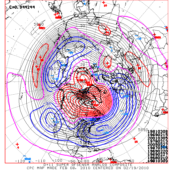
More cold air on the way next week!?
-
srainhoutx

- Site Admin

- Posts: 19616
- Joined: Tue Feb 02, 2010 2:32 pm
- Location: Maggie Valley, NC
- Contact:
Carla/Alicia/Jerry(In The Eye)/Michelle/Charley/Ivan/Dennis/Katrina/Rita/Wilma/Humberto/Ike/Harvey
Member: National Weather Association
Facebook.com/Weather Infinity
Twitter @WeatherInfinity
Member: National Weather Association
Facebook.com/Weather Infinity
Twitter @WeatherInfinity
-
sleetstorm
- Posts: 651
- Joined: Thu Feb 04, 2010 12:33 pm
- Contact:
Laugh out loud.wxman57 wrote:I had predicted 31-24 Saints. Now, I'll work a miracle for sleetstorm. I'll see if I can get him some sleet for next Friday morning.
If the Saints can win the superbowl, then frozen precip can reach Houston.
Models should now have a pretty good handle on things. I'll check in tomorrow after the 12Z models.
-
sleetstorm
- Posts: 651
- Joined: Thu Feb 04, 2010 12:33 pm
- Contact:
Laughed out loud.


That's a really good prediction! Now, let's hope you can predict snow.wxman57 wrote:I had predicted 31-24 Saints. Now, I'll work a miracle for sleetstorm. I'll see if I can get him some sleet for next Friday morning.
If the Saints can win the superbowl, then frozen precip can reach Houston.
Models should now have a pretty good handle on things. I'll check in tomorrow after the 12Z models.
I expect changes again,Ed Mahmoud wrote:Just checked my raw numbers from the PPV AccuWx site, GFS might have a few flakes at the very beginning in College Station, but basically cold rain everywhere locally.
Longview, TX, however, close to 6 inches of Winter joy.
-
DougNTexas
- Posts: 3
- Joined: Fri Feb 05, 2010 11:29 pm
- Contact:
It would thrill me if Longview/Henderson got 6 inches of snow!!!

SPC has raised severe weather threat to low for SE TX.
"THE PRESENCE OF 40-50 KT OF DEEP-LAYER SHEAR MAY PROMOTE A FEW STRONGER/MORE ORGANIZED STORMS CAPABLE OF LOCALLY STRONG WIND GUSTS AND PERHAPS A BRIEF TORNADO. HOWEVER...THE WEAK CONVECTIVE INSTABILITY AND POTENTIAL FOR STORMS TO REMAIN SLIGHTLY ELEVATED ARE EXPECTED TO LIMIT A MORE ROBUST SEVERE WEATHER THREAT."
1.Tornado Threat
2. Damaging Winds

I took this from the 72 range to the 102 hr range.
It appears the Houston areas best chances come at the onset of the moisture shield moving in,
Appears the big D could get some measurable snowfall. Us down here, maybe a flake or two mixed in with a sleet pellet now and then.
Of course this is subject to change, and honestly I hope it does. But I'll tell ya if wxman57's not seeing this event four to five days out, like he did when the Dec. 4th miracle came knocking, I'm not holding my breath.
-
srainhoutx
- Site Admin
- Posts: 19616
- Joined: Tue Feb 02, 2010 2:32 pm
- Location: Maggie Valley, NC
- Contact:
HGX hinting, but not ready to pull the trigger just yet...
AREA FORECAST DISCUSSION
NATIONAL WEATHER SERVICE HOUSTON/GALVESTON TX
511 AM CST MON FEB 8 2010
.DISCUSSION...
DISCUSSION... AREAS OF -RA STARTING TO DEVELOP UNDER THE STRONG
LLJ ACROSS WRN PARTS OF THE REGION. EXPECT THE JET AND ASSOCIATED
-RA TO GRADUALLY SHIFT EWD THRU THE DAY. COLD FRONT STILL ON TRACK
TO APPROACH NRN PARTS OF SE TX LATE THIS AFTN & EARLY EVNG AND
QUICKLY PUSH OFF THE COAST BY 9-10PM. WILL PROBABLY SEE A BAND OF
SHRA/ISO TSTMS ALONG THE BOUNDARY...AND COULD SEE A FEW EMBEDDED
STRONGER STORMS WITHIN THE LINE...BUT OVERALL INSTABILITY SHOULD
BE LACKING FOR MUCH IN THE WAY OF A WIDESPREAD SVR WX THREAT.
LOOKING LIKE A WIND ADVISORY WILL BE NEEDED FOR PORTIONS OF THE
AREA BEHIND THE FRONT...ESP COASTAL COUNTIES...BUT WILL LET THE
NEXT SHIFT TAKE CARE OF THAT AFTER VERIFYING TIMING AND DETAILS.
MAY SEE A FEW PEAKS OF THE SUN ON TUES BUT MID/HIGH LVL CLOUDS
SHOULD FILL BACK IN BY EVNG.
MEDIUM RANGE MODELS HAVE (FINALLY) BECOME IN MUCH BETTER AGREEMENT
REGARDING THE MID & EXTENDED RANGE OF THE FCST. ATMOS SHOULD
CONTINUE TO MOISTEN INTO MIDWEEK WITH AN ACTIVE SW FLOW ALOFT AND
APPROACHING TROF WED-FRI. SHOULD BE ENOUGH MOISTURE IN PLACE FOR
SOME RAIN TO BEGIN FALLING BY WED EVNG. AND WHAT IS SOUNDING LIKE A
BROKEN RECORD THIS WINTER...A DEVELOPING COASTAL LOW WILL AID IN
ISENTROPIC LIFT. LOOKING LIKE WIDESPREAD RAINFALL ON THURS THEN
DECREASING CHANCES FROM WEST TO EAST ON FRI AS THE COASTAL LOW AND
UPPER TROF MOVE OFF TO THE EAST. LATER SHIFTS WILL NEED TO KEEP AN
EYE ON NRN ZONES WED NT & AGAIN THU NIGHT TO EVALUATE POTENTIAL
FOR A WINTER PRECIP MIX. MODELS HAVE BEEN SHOWING THIS OFF AND ON
FOR A SEVERAL DAYS. STILL LOOKS BORDERLINE...BUT SOUNDING PROFILES
SHOW THE POTENTIAL FOR SOME EVAP COOLING THAT COULD SWING THINGS.
47
Austin/San Antonio on the other hand is a bit more bullish...
AREA FORECAST DISCUSSION
NATIONAL WEATHER SERVICE AUSTIN/SAN ANTONIO TX
551 AM CST MON FEB 8 2010
.DISCUSSION...
STRONG BLAST OF COLD AIR TODAY WILL BRING A POTENTIAL FOR WINTER
WEATHER THIS WEEK.
FORECAST TRENDS CONTINUE TO BRING THE ARCTIC COLD FRONT AHEAD OF
SCHEDULE WITH THE FRONT NOW EXPECTED TO DROP INTO THE AREA THIS
AFTERNOON AND INFLUENCE HIGH TEMPS FOR THE NORTHERN COUNTIES.
FREEZING CONDITIONS ARE EXPECTED TO DEVELOP OVER NORTHERN COUNTIES
TONIGHT AND COULD POTENTIALLY BE COLDER THAN THE CURRENT FORECAST.
THE MORNING PACKAGE REFLECTS THE ALREADY AGREESSIVE GFS BASED
NUMBERS. SOME MODIFICATION COULD DEVLEOP AS THE COLD AIR MASS
REACHES THE SOAKED SOILS OF SOUTH CENTRAL TEXAS SO MAINLY LIGHT
FREEZES ARE EXPECTED OVER NORTHERN AREAS WITH ABOVE FREEZING
CONDITIONS OVER SOUTHERN COUNTIES FOR TUESDAY MORNING. THE AIR
DRIES OUT FOR TUESDAY SETTING UP THE STAGE FOR A POTENTIAL WINTER
WEATHER EVENT FOR THE NEXT APPROACHING DISTURBANCE.
A EXIT REGION OF A SUBTROPICAL JET STREAK SHOULD GENERATE SYNOPTIC
LIFT AND LIGHT ELEVATED SNOW FALLING OVER MEXICO WESTERN COUNTIES
BY LATE TUESDAY NIGHT. IF LOW-MID LEVEL MOISTURE POOLING IS
SUFFICIENT ALONG THE RIO GRANDE AT THIS TIME...SOME SLEET COULD
ALSO DEVELOP. THIS VERY LIGHT PRECIPITATION PATTERN IS NOT
EXPECTED TO PRODUCE A SIGNIFICANT ROUND OF WINTER
PRECIPITATION...BUT THE MOISTENING AND COOLING EFFECTS COULD
INFLUENCE PRECIPITATION TYPE WHEN AN APPROACHING PACIFIC TROUGH
BEGINS TO IMPACT TX WEDNESDAY NIGHT.
STRONG GULF MOISTURE ADVECTION IS EXPECTED BY WED NIGHT...AND
FORECAST SOUNDINGS SHOW A DEEP COLUM OF TEMPERATURES HOVERING NEAR
FREEZING. THEREFORE A RAIN/SNOW MIX COULD BE THE MOST LIKELY TYPE
FOR THE PERIOD FROM WEDNESDAY NIGHT INTO THURSDAY. THE WARMER NAM
MODEL STILL SHOWS A SIGNIFICANT DEPTH OF TEMPS ABOVE FREEZING...
AND EVAPORATION OF MIXED PRECIPIATION MOVING INTO THE AREA
WEDNESDAY COULD ALTER LOW LEVEL PROFILES ENOUGH TO SUPPORT
CONTINUED SLEET. THUS CONFIDENCE FOR THIS EVENT REMAINS LOW. THE
PRESENCE OF DEEP MOISTURE FOR THE LARGER SYSTEM COMBINED WITH WARM
AND MOIST SOIL CONDITIONS LEADS ME TO THINK WE SHOULD SEE MOST OF
THE FALLING ICE MELTING ON CONTACT. THUS WILL NOT ANTICIPATE ANY
ACCUMULATIONS YET. FOR NOW...WILL ADDRESS THE POTENTIAL WX EVENT
WITH THE HWO...SPS...AND GRAPHICASTS.
THE GFS REMAINS QUITE COLD AND WET WITH AN OVERRUNING PATTERN
BECOMING ESTABLISHED AGAIN OVER THE WEEKEND. AGAIN IT REMAINS
AMONG THE STRONGER MODELS IN HANDLING THE SOUTHERN STREAM
DISTURBANCES AND OVERRUNNING.
AREA FORECAST DISCUSSION
NATIONAL WEATHER SERVICE HOUSTON/GALVESTON TX
511 AM CST MON FEB 8 2010
.DISCUSSION...
DISCUSSION... AREAS OF -RA STARTING TO DEVELOP UNDER THE STRONG
LLJ ACROSS WRN PARTS OF THE REGION. EXPECT THE JET AND ASSOCIATED
-RA TO GRADUALLY SHIFT EWD THRU THE DAY. COLD FRONT STILL ON TRACK
TO APPROACH NRN PARTS OF SE TX LATE THIS AFTN & EARLY EVNG AND
QUICKLY PUSH OFF THE COAST BY 9-10PM. WILL PROBABLY SEE A BAND OF
SHRA/ISO TSTMS ALONG THE BOUNDARY...AND COULD SEE A FEW EMBEDDED
STRONGER STORMS WITHIN THE LINE...BUT OVERALL INSTABILITY SHOULD
BE LACKING FOR MUCH IN THE WAY OF A WIDESPREAD SVR WX THREAT.
LOOKING LIKE A WIND ADVISORY WILL BE NEEDED FOR PORTIONS OF THE
AREA BEHIND THE FRONT...ESP COASTAL COUNTIES...BUT WILL LET THE
NEXT SHIFT TAKE CARE OF THAT AFTER VERIFYING TIMING AND DETAILS.
MAY SEE A FEW PEAKS OF THE SUN ON TUES BUT MID/HIGH LVL CLOUDS
SHOULD FILL BACK IN BY EVNG.
MEDIUM RANGE MODELS HAVE (FINALLY) BECOME IN MUCH BETTER AGREEMENT
REGARDING THE MID & EXTENDED RANGE OF THE FCST. ATMOS SHOULD
CONTINUE TO MOISTEN INTO MIDWEEK WITH AN ACTIVE SW FLOW ALOFT AND
APPROACHING TROF WED-FRI. SHOULD BE ENOUGH MOISTURE IN PLACE FOR
SOME RAIN TO BEGIN FALLING BY WED EVNG. AND WHAT IS SOUNDING LIKE A
BROKEN RECORD THIS WINTER...A DEVELOPING COASTAL LOW WILL AID IN
ISENTROPIC LIFT. LOOKING LIKE WIDESPREAD RAINFALL ON THURS THEN
DECREASING CHANCES FROM WEST TO EAST ON FRI AS THE COASTAL LOW AND
UPPER TROF MOVE OFF TO THE EAST. LATER SHIFTS WILL NEED TO KEEP AN
EYE ON NRN ZONES WED NT & AGAIN THU NIGHT TO EVALUATE POTENTIAL
FOR A WINTER PRECIP MIX. MODELS HAVE BEEN SHOWING THIS OFF AND ON
FOR A SEVERAL DAYS. STILL LOOKS BORDERLINE...BUT SOUNDING PROFILES
SHOW THE POTENTIAL FOR SOME EVAP COOLING THAT COULD SWING THINGS.
47
Austin/San Antonio on the other hand is a bit more bullish...
AREA FORECAST DISCUSSION
NATIONAL WEATHER SERVICE AUSTIN/SAN ANTONIO TX
551 AM CST MON FEB 8 2010
.DISCUSSION...
STRONG BLAST OF COLD AIR TODAY WILL BRING A POTENTIAL FOR WINTER
WEATHER THIS WEEK.
FORECAST TRENDS CONTINUE TO BRING THE ARCTIC COLD FRONT AHEAD OF
SCHEDULE WITH THE FRONT NOW EXPECTED TO DROP INTO THE AREA THIS
AFTERNOON AND INFLUENCE HIGH TEMPS FOR THE NORTHERN COUNTIES.
FREEZING CONDITIONS ARE EXPECTED TO DEVELOP OVER NORTHERN COUNTIES
TONIGHT AND COULD POTENTIALLY BE COLDER THAN THE CURRENT FORECAST.
THE MORNING PACKAGE REFLECTS THE ALREADY AGREESSIVE GFS BASED
NUMBERS. SOME MODIFICATION COULD DEVLEOP AS THE COLD AIR MASS
REACHES THE SOAKED SOILS OF SOUTH CENTRAL TEXAS SO MAINLY LIGHT
FREEZES ARE EXPECTED OVER NORTHERN AREAS WITH ABOVE FREEZING
CONDITIONS OVER SOUTHERN COUNTIES FOR TUESDAY MORNING. THE AIR
DRIES OUT FOR TUESDAY SETTING UP THE STAGE FOR A POTENTIAL WINTER
WEATHER EVENT FOR THE NEXT APPROACHING DISTURBANCE.
A EXIT REGION OF A SUBTROPICAL JET STREAK SHOULD GENERATE SYNOPTIC
LIFT AND LIGHT ELEVATED SNOW FALLING OVER MEXICO WESTERN COUNTIES
BY LATE TUESDAY NIGHT. IF LOW-MID LEVEL MOISTURE POOLING IS
SUFFICIENT ALONG THE RIO GRANDE AT THIS TIME...SOME SLEET COULD
ALSO DEVELOP. THIS VERY LIGHT PRECIPITATION PATTERN IS NOT
EXPECTED TO PRODUCE A SIGNIFICANT ROUND OF WINTER
PRECIPITATION...BUT THE MOISTENING AND COOLING EFFECTS COULD
INFLUENCE PRECIPITATION TYPE WHEN AN APPROACHING PACIFIC TROUGH
BEGINS TO IMPACT TX WEDNESDAY NIGHT.
STRONG GULF MOISTURE ADVECTION IS EXPECTED BY WED NIGHT...AND
FORECAST SOUNDINGS SHOW A DEEP COLUM OF TEMPERATURES HOVERING NEAR
FREEZING. THEREFORE A RAIN/SNOW MIX COULD BE THE MOST LIKELY TYPE
FOR THE PERIOD FROM WEDNESDAY NIGHT INTO THURSDAY. THE WARMER NAM
MODEL STILL SHOWS A SIGNIFICANT DEPTH OF TEMPS ABOVE FREEZING...
AND EVAPORATION OF MIXED PRECIPIATION MOVING INTO THE AREA
WEDNESDAY COULD ALTER LOW LEVEL PROFILES ENOUGH TO SUPPORT
CONTINUED SLEET. THUS CONFIDENCE FOR THIS EVENT REMAINS LOW. THE
PRESENCE OF DEEP MOISTURE FOR THE LARGER SYSTEM COMBINED WITH WARM
AND MOIST SOIL CONDITIONS LEADS ME TO THINK WE SHOULD SEE MOST OF
THE FALLING ICE MELTING ON CONTACT. THUS WILL NOT ANTICIPATE ANY
ACCUMULATIONS YET. FOR NOW...WILL ADDRESS THE POTENTIAL WX EVENT
WITH THE HWO...SPS...AND GRAPHICASTS.
THE GFS REMAINS QUITE COLD AND WET WITH AN OVERRUNING PATTERN
BECOMING ESTABLISHED AGAIN OVER THE WEEKEND. AGAIN IT REMAINS
AMONG THE STRONGER MODELS IN HANDLING THE SOUTHERN STREAM
DISTURBANCES AND OVERRUNNING.
Carla/Alicia/Jerry(In The Eye)/Michelle/Charley/Ivan/Dennis/Katrina/Rita/Wilma/Humberto/Ike/Harvey
Member: National Weather Association
Facebook.com/Weather Infinity
Twitter @WeatherInfinity
Member: National Weather Association
Facebook.com/Weather Infinity
Twitter @WeatherInfinity
-
Portastorm

- Posts: 800
- Joined: Wed Feb 03, 2010 3:04 pm
- Location: Southwest Austin/Oak Hill, TX
- Contact:
Thanks for posting srainhoutx. I was going to include the Austin/San Antonio morning AFD in my post here but you saved me the trouble!  Gotta give credit where credit is due ... I think this is an excellent discussion that lays out the parameters for the week ahead, at least in the AUS/SAT area.
-
srainhoutx
- Site Admin
- Posts: 19616
- Joined: Tue Feb 02, 2010 2:32 pm
- Location: Maggie Valley, NC
- Contact:
Yeah Portastorm, I was actually abit surprised to see that HGX has started to mention the wintry issue, but the sounding data is hard to dismiss. You folks a bit further W in and near the Hill Country need to watch this storm carefully as well as we folks in areas N and W of Downtown Houston. It looks to be a real close call and certainly bears watching for all. Expect further 'fine tuning' as the event nears.
Carla/Alicia/Jerry(In The Eye)/Michelle/Charley/Ivan/Dennis/Katrina/Rita/Wilma/Humberto/Ike/Harvey
Member: National Weather Association
Facebook.com/Weather Infinity
Twitter @WeatherInfinity
Member: National Weather Association
Facebook.com/Weather Infinity
Twitter @WeatherInfinity
-
srainhoutx
- Site Admin
- Posts: 19616
- Joined: Tue Feb 02, 2010 2:32 pm
- Location: Maggie Valley, NC
- Contact:
Another note worthy issue is that the pattern may be locked in for a while. Next weekend may need to be watched as well...
PRELIMINARY EXTENDED FORECAST DISCUSSION
NWS HYDROMETEOROLOGICAL PREDICTION CENTER CAMP SPRINGS MD
749 AM EST MON FEB 08 2010
VALID 12Z FRI FEB 12 2010 - 12Z MON FEB 15 2010
TELECONNECTIONS WITH A STRONG POSITIVE ANOMALY IN THE MID-LEVELS
OVER NORTHEAST CANADA /BETWEEN 3 AND 4 STANDARD DEVIATIONS ABOVE
NORMAL/ FAVORS PROGRESSIVE CLOSED CYCLONES UNDER ITS BASE IN THE
LOWER 40S LATITUDE. THIS ALLOWS US TO DISCARD THE 00Z CANADIAN
WHICH LEAVES A CLOSED CYCLONE QUASI-STATIONARY IN THE NORTHERN
PLAINS/UPPER MIDWEST LATE IN THE PERIOD. SHORTWAVE ENERGY IN THE
SOUTHERN STREAM IS EXPECTED TO REMAIN PROGRESSIVE ACROSS THE
SOUTHERN TIER OF THE COUNTRY THROUGH THE FORESEEABLE FUTURE. DUE
TO THE PROGRESSION EXPECTED IN THE NORTHERN AND SOUTHERN STREAMS
AS WELL AS QUESTIONS REGARDING FUTURE INTERACTIONS BETWEEN THE TWO
STREAMS... CONFIDENCE IN THE FORECAST LATE THIS WEEKEND INTO EARLY
NEXT WEEK IS LOW IN ANY PARTICULAR PIECE OF DETERMINISTIC
GUIDANCE...WHICH IS LIKELY TO SHOW RUN-TO-RUN AND DAY-TO-DAY
DIFFERENCES REGARDING PROGRESSION AND PHASING. BOTH THE 06Z GEFS
MEAN AND 00Z ECMWF ENSEMBLE MEANS ARE IN REASONABLE AGREEMENT
THROUGH THE PERIOD. IN ORDER TO RESOLVE DETAIL ISSUES...CHOSE TO
COMPROMISE BETWEEN THE 00Z ECMWF AND 06Z GEFS MEAN
SOLUTIONS...WITH SOME MODIFICATIONS MADE PER 00Z MULTI-MODEL
ENSEMBLE LOW PRESSURE AREA CLUSTERING...SUCH AS LATE IN THE PERIOD
IN THE GULF OF MEXICO.
ROTH
Carla/Alicia/Jerry(In The Eye)/Michelle/Charley/Ivan/Dennis/Katrina/Rita/Wilma/Humberto/Ike/Harvey
Member: National Weather Association
Facebook.com/Weather Infinity
Twitter @WeatherInfinity
Member: National Weather Association
Facebook.com/Weather Infinity
Twitter @WeatherInfinity
-
wxman57

- Global Moderator

- Posts: 2621
- Joined: Thu Feb 04, 2010 5:34 am
- Location: Southwest Houston (Westbury)
- Contact:
Model agreement continues to improve, though I'm still skeptical of the amount of moisture indicated across central and NE TX according to the latest GFS runs. However, what I'm seeing indicates a good chance of some sleet and a bit of snow as far south as Austin Thursday evening, with soundings indicating snow in the Dallas area. First let's look at Houston.
Everything points to MOSTLY an all-rain event in the greater Houston area, an all VERY COLD rain event. The "problem", as can be seen on the Skew-T vertical profile for Thursday evening is that there is forecast to be a warm layer from the surface to 10,000 ft, with temps up into the mid 40s aloft. Any snow falling from above that would melt and not re-freeze before reaching the ground, making snow/sleet unlikely in Houston. Even looking at soundings as the precip ends, temps aloft aren't cold enough except for maybe a couple of minutes Thursday night. But then, moisture is fading fast as temps aloft drop.
That said, there may be a chance of frozen precip in Houston, but not as the precip ends (which would be typical). As the precip starts on Wednesday morning, vertical profiles indicate that moisture falling from above 6000 ft may fall as sleet or even snow. But temps aloft warm during the day Wednesday, assuring that cold rain will be the general rule.
Houston 06Z GFS Meteogram:

Houston Skew-T Valid 6pm Thursday:

Houston Skew-T Valid 9pm 9PM Wednesday:

Austin is more of a challenge. Their meteogram puts surface temps very close to freezing. But vertical profiles also indicate temps very close to freezing below 10,000ft. No big warm layer aloft. You could see a change over to snow Thursday night as the precip comes to an end, but I don't think you'll see significant accumulations.
Austin 06Z GFS Meteogram:

As for the Dallas-Ft. Worth area, forecast soundings and meteograms indicate mostly snow for over 24 hours beginning Wednesday afternoon. I do agree that snow looks likely there now. HOWEVER, I'm still skeptical of the amounts projected by the GFS. It does tend to over-forecast moisture amounts well inland with West Gulf Low developments. So hope for a big snow event in Dallas, but be a little skeptical for now about the amounts.
Dallas (DFW) 06Z GFS Meteogram:

Dallas-Ft. Worth Skew-T Valid 6pm Thursday:

Finally, Wichita Falls. That's really getting too far north for significant accumulations with a West Gulf Low, and even the latest GFS agrees. It still may be overdoing the available moisture at forecasting a few inches into SPS:

Everything points to MOSTLY an all-rain event in the greater Houston area, an all VERY COLD rain event. The "problem", as can be seen on the Skew-T vertical profile for Thursday evening is that there is forecast to be a warm layer from the surface to 10,000 ft, with temps up into the mid 40s aloft. Any snow falling from above that would melt and not re-freeze before reaching the ground, making snow/sleet unlikely in Houston. Even looking at soundings as the precip ends, temps aloft aren't cold enough except for maybe a couple of minutes Thursday night. But then, moisture is fading fast as temps aloft drop.
That said, there may be a chance of frozen precip in Houston, but not as the precip ends (which would be typical). As the precip starts on Wednesday morning, vertical profiles indicate that moisture falling from above 6000 ft may fall as sleet or even snow. But temps aloft warm during the day Wednesday, assuring that cold rain will be the general rule.
Houston 06Z GFS Meteogram:
Houston Skew-T Valid 6pm Thursday:
Houston Skew-T Valid 9pm 9PM Wednesday:
Austin is more of a challenge. Their meteogram puts surface temps very close to freezing. But vertical profiles also indicate temps very close to freezing below 10,000ft. No big warm layer aloft. You could see a change over to snow Thursday night as the precip comes to an end, but I don't think you'll see significant accumulations.
Austin 06Z GFS Meteogram:
As for the Dallas-Ft. Worth area, forecast soundings and meteograms indicate mostly snow for over 24 hours beginning Wednesday afternoon. I do agree that snow looks likely there now. HOWEVER, I'm still skeptical of the amounts projected by the GFS. It does tend to over-forecast moisture amounts well inland with West Gulf Low developments. So hope for a big snow event in Dallas, but be a little skeptical for now about the amounts.
Dallas (DFW) 06Z GFS Meteogram:
Dallas-Ft. Worth Skew-T Valid 6pm Thursday:
Finally, Wichita Falls. That's really getting too far north for significant accumulations with a West Gulf Low, and even the latest GFS agrees. It still may be overdoing the available moisture at forecasting a few inches into SPS:
-
srainhoutx
- Site Admin
- Posts: 19616
- Joined: Tue Feb 02, 2010 2:32 pm
- Location: Maggie Valley, NC
- Contact:
Thanks for the Update wxman57. As I posted earlier, the pattern is showing signs of locking in to a colder and stormier regime for the remainder of the month. The CPC Super Ensembles paints a very interesting picture for this time of year and unfortunately it appears that the winter of 2009/2010 may yet offer more surprises as we head into the end of the month. I am ready for Spring!
Carla/Alicia/Jerry(In The Eye)/Michelle/Charley/Ivan/Dennis/Katrina/Rita/Wilma/Humberto/Ike/Harvey
Member: National Weather Association
Facebook.com/Weather Infinity
Twitter @WeatherInfinity
Member: National Weather Association
Facebook.com/Weather Infinity
Twitter @WeatherInfinity
I am ready for a break from the rain. I can't even walk in my yard - its a layer of water.
For those that watch the long-range forecasts - will the wet/rainy season continue into March?
For those that watch the long-range forecasts - will the wet/rainy season continue into March?
Last edited by ticka1 on Mon Feb 08, 2010 9:16 am, edited 1 time in total.
-
srainhoutx
- Site Admin
- Posts: 19616
- Joined: Tue Feb 02, 2010 2:32 pm
- Location: Maggie Valley, NC
- Contact:
ticka1, as long as the fire hose of moisture streams in from the Pacific we will likely remain wet. At this time I see no signs that the pattern will break down. Perhaps a day or so of clear weather between systems if we are lucky, but that is about it. I wish I had better news, but this is the pattern we are stuck in for the foreseeable future IMHO.ticka1 wrote:I am ready for a break from the rain. I can't even walk in my yard - its a layer of water.
For those that watch the long-range forecasts - will the wet/rainy season continue into March?
Carla/Alicia/Jerry(In The Eye)/Michelle/Charley/Ivan/Dennis/Katrina/Rita/Wilma/Humberto/Ike/Harvey
Member: National Weather Association
Facebook.com/Weather Infinity
Twitter @WeatherInfinity
Member: National Weather Association
Facebook.com/Weather Infinity
Twitter @WeatherInfinity

GFS shows temps at (Hooks) in the mid 30's (35F-36F) during the peak of precip (temps only have to be 2-4 degrees cooler for precip too probably change over to the frozen variety) if we could get some wet bulbing/evaperating cooling things could definatly get interesting for northern areas.But im not sure whats the chances of that happening...?
-
wxman57
- Global Moderator
- Posts: 2621
- Joined: Thu Feb 04, 2010 5:34 am
- Location: Southwest Houston (Westbury)
- Contact:
Just remember that though surface temps are forecast to be in the 35-36F range at peak precip, temps a few thousand feet above the surface are forecast to be about 10 degrees warmer. It'll take quite a bit of cooling throughout the atmosphere to give us frozen precip.don wrote:GFS shows temps at (Hooks) in the mid 30's (35F-36F) during the peak of precip (temps only have to be 2-4 degrees cooler for precip too probably change over to the frozen variety) if we could get some wet bulbing/evaporative cooling things could definitely get interesting for northern areas.But im not sure whats the chances of that happening...?
-
srainhoutx
- Site Admin
- Posts: 19616
- Joined: Tue Feb 02, 2010 2:32 pm
- Location: Maggie Valley, NC
- Contact:
For what it is worth the 12Z GFS is a tad colder with the 850's and further S as the precip starts.
Carla/Alicia/Jerry(In The Eye)/Michelle/Charley/Ivan/Dennis/Katrina/Rita/Wilma/Humberto/Ike/Harvey
Member: National Weather Association
Facebook.com/Weather Infinity
Twitter @WeatherInfinity
Member: National Weather Association
Facebook.com/Weather Infinity
Twitter @WeatherInfinity
-
srainhoutx
- Site Admin
- Posts: 19616
- Joined: Tue Feb 02, 2010 2:32 pm
- Location: Maggie Valley, NC
- Contact:
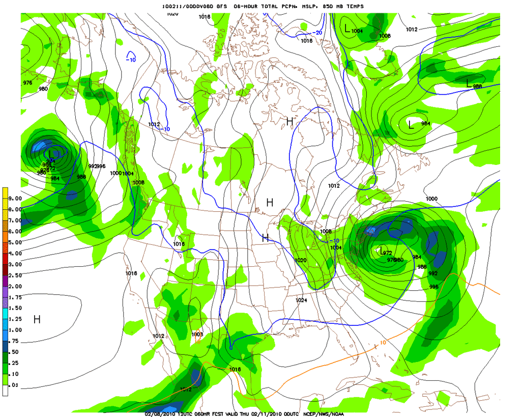
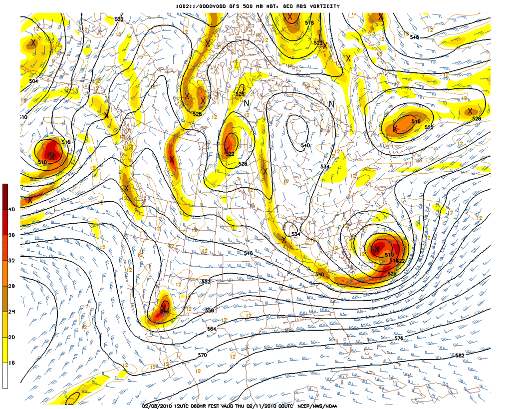
Folks up near Dallas/Ft Worth may need to pay close attention. The 12Z GFS paints a rather significant snow event for our neighbors to the N.
Carla/Alicia/Jerry(In The Eye)/Michelle/Charley/Ivan/Dennis/Katrina/Rita/Wilma/Humberto/Ike/Harvey
Member: National Weather Association
Facebook.com/Weather Infinity
Twitter @WeatherInfinity
Member: National Weather Association
Facebook.com/Weather Infinity
Twitter @WeatherInfinity