http://hurricane.atmos.colostate.edu/Fo ... ec2011.pdf
They are predicting that El Nino may occur in 2012.
Brief Quantitative Forecast For 2012
- Ptarmigan
- Statistical Specialist

- Posts: 4494
- Joined: Wed Feb 03, 2010 7:20 pm
- Contact:
- wxman57
- Global Moderator

- Posts: 2621
- Joined: Thu Feb 04, 2010 5:34 am
- Location: Southwest Houston (Westbury)
- Contact:
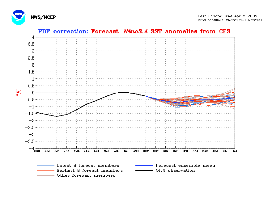
The more I look at the data, the more I'm inclined to think that there will be at least a weak El Nino next summer. We're following the 2008 pattern very closely ENSO-wise, just a little ahead on the late fall cooling. In November of 2008, the forecast for Nino 3.4 was for a weak La Nina in 2009:
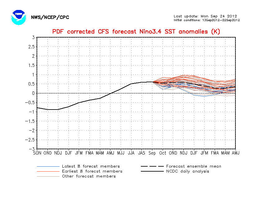
And that's VERY similar to the current forecast for next spring/early summer:
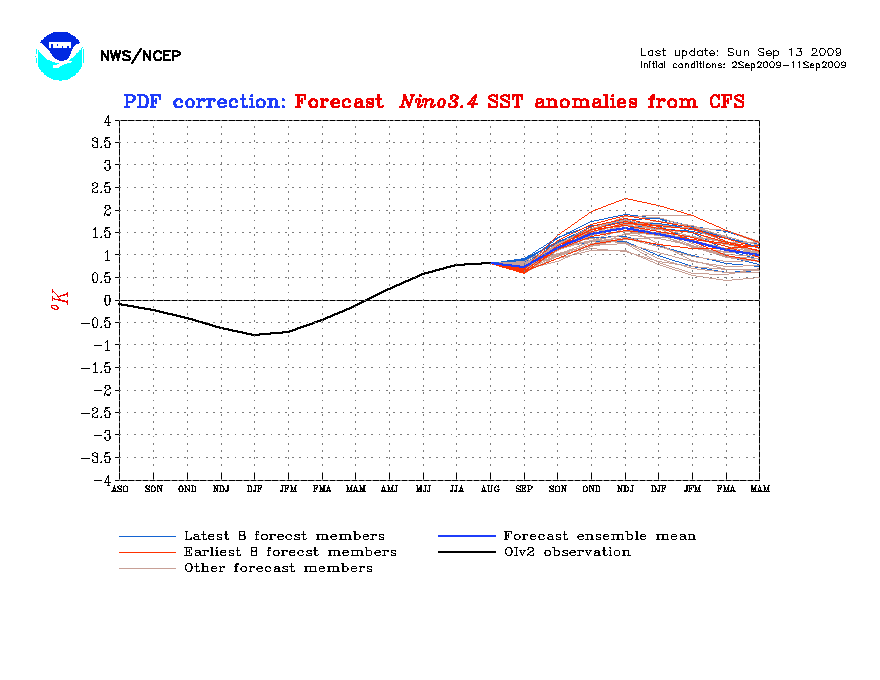
In 2008, the SSTs actually cooled more than was forecast in December, down to -1C. But there certainly was no La Nina in 2009, as you can see by the following graphic:
That said, I wouldn't be surprised if SSTs are +.4C to +.7C in Nino 3.4 by next July. That could mean well below the 1995-2011 norms (15/8/4) for 2012. Possibly 10-12 named storms, 5-6 hurricanes and 2-3 intense hurricanes.

And that's VERY similar to the current forecast for next spring/early summer:

In 2008, the SSTs actually cooled more than was forecast in December, down to -1C. But there certainly was no La Nina in 2009, as you can see by the following graphic:

That said, I wouldn't be surprised if SSTs are +.4C to +.7C in Nino 3.4 by next July. That could mean well below the 1995-2011 norms (15/8/4) for 2012. Possibly 10-12 named storms, 5-6 hurricanes and 2-3 intense hurricanes.
- Ptarmigan
- Statistical Specialist

- Posts: 4494
- Joined: Wed Feb 03, 2010 7:20 pm
- Contact:
If we went La Nina to El Nino in 2012, it would be a first since 2009. The winter of 2009-2010 was cold and snowed twice. It is one of the coldest on record besides 1894-1895, 1977-1978, and 1983-1984.
- Paul
- Posts: 535
- Joined: Wed Feb 03, 2010 11:46 pm
- Location: Pearland
- Contact:
I am still hanging on to nuetral conditions. Not sold on El Nino just yet. edit to add until I sit through an Impact Weather Seminar in May that is.... 
- wxman57
- Global Moderator

- Posts: 2621
- Joined: Thu Feb 04, 2010 5:34 am
- Location: Southwest Houston (Westbury)
- Contact:
I was talking to Phil Klotzbach a couple of days ago about the possible El Nino and the Euro's forecast of above-normal pressures all across the Atlantic Basin this summer. The words "dud season" were mentioned. Doesn't matter if we only see 9 or 10 named storms, though, it just takes one. There have been some major impacts during past "inactive" El Nino seasons. Storms like Andrew or Betsy or Hugo or Alicia, and there were others.
- Ptarmigan
- Statistical Specialist

- Posts: 4494
- Joined: Wed Feb 03, 2010 7:20 pm
- Contact:
If I recall, 1989 was a Neutral season and the most active in the "cool" phase of the Atlantic from 1970 to 1994. Some active seasons were El Nino seasons like 1969 and 2004. 1998 had 14 named storms and it was very deadly. 1999 had 12 storms and it had 5 major hurricanes and it was a devastating year as well.wxman57 wrote:I was talking to Phil Klotzbach a couple of days ago about the possible El Nino and the Euro's forecast of above-normal pressures all across the Atlantic Basin this summer. The words "dud season" were mentioned. Doesn't matter if we only see 9 or 10 named storms, though, it just takes one. There have been some major impacts during past "inactive" El Nino seasons. Storms like Andrew or Betsy or Hugo or Alicia, and there were others.
- srainhoutx
- Site Admin

- Posts: 19700
- Joined: Tue Feb 02, 2010 2:32 pm
- Location: Maggie Valley, NC
- Contact:
Dr. Klotzbach & Dr. Gray release a brief update prior to the National Hurricane Conference next week in Orlando...
http://hurricane.atmos.colostate.edu/Fo ... ar2012.pdfThe combination of a warming tropical Pacific and a cooling tropical Atlantic are leading us to think that the 2012 Atlantic hurricane season will have less activity than the average 1981-2010 season. However, we stress the need to realize that there is inherent uncertainty in seasonal TC prediction. In addition, hurricanes can make landfall in inactive seasons and do major damage (e.g., Alicia in 1983 and Andrew in 1992). Coastal residents need to prepare the same for every hurricane season. A full discussion of the outlook for the 2012 Atlantic hurricane season will be available with the first quantitative forecast issued on Wednesday, April 4. This forecast will include predictions for numbers of named storms, hurricanes, major hurricanes, etc.
Carla/Alicia/Jerry(In The Eye)/Michelle/Charley/Ivan/Dennis/Katrina/Rita/Wilma/Humberto/Ike/Harvey
Member: National Weather Association
Facebook.com/Weather Infinity
Twitter @WeatherInfinity
Member: National Weather Association
Facebook.com/Weather Infinity
Twitter @WeatherInfinity
- Ptarmigan
- Statistical Specialist

- Posts: 4494
- Joined: Wed Feb 03, 2010 7:20 pm
- Contact:
- wxman57
- Global Moderator

- Posts: 2621
- Joined: Thu Feb 04, 2010 5:34 am
- Location: Southwest Houston (Westbury)
- Contact:
Just remember that 1957 (Audrey), 1965 (Betsy), 1983 (Alicia) and 1992 (Andrew) were "dud" years numbers-wise. I expect only around 9-10 named storms in 2012, but that doesn't preclude the possibility of a major strike SOMEWHERE. We just don't know where. I'll be talking to Phil this evening. His talk here at the NHC is tomorrow morning.
- Ptarmigan
- Statistical Specialist

- Posts: 4494
- Joined: Wed Feb 03, 2010 7:20 pm
- Contact:
1957 and 1965 were El Nino. I think this season could be less active as well.Ed Mahmoud wrote:wxman57 wrote:Just remember that 1957 (Audrey), 1965 (Betsy), 1983 (Alicia) and 1992 (Andrew) were "dud" years numbers-wise. I expect only around 9-10 named storms in 2012, but that doesn't preclude the possibility of a major strike SOMEWHERE. We just don't know where. I'll be talking to Phil this evening. His talk here at the NHC is tomorrow morning.
57 and 65 don't look like "duds", exactly, NTC of 70 or 80 is slow, but not "dud". 1983, now that was a dud.
A California cyclone chaser has noted 1959 was a warm ENSO year, had 11 storms, 7 hurricanes and 2 majors. Cat 1 near Freeport, an El Niño special, developed from a cut off polar low (yes, I know how to use Wiki), which would liven up the forum but probably spare the vacation homes of Galveston island retirees ( at least the vacation homes that survived Claudette), and a major landfall in South Carolina, Cat 3 Gracie which had been a Cat 4 offshore.
Hurricane Gracie PDF w/ pictures.
http://www.erh.noaa.gov/chs/events/Hurr ... hAnniv.pdf
Our WxMan57 reported a discussion with Dr. Klotzbach where the word "dud" was used. I found a graph of seasonal NTC, and while I couldn't read exact values, 1992 was barely over 50. 1983 was below 50...And a warm ENSO could mean the rare Hawai'ian activity.
- srainhoutx
- Site Admin

- Posts: 19700
- Joined: Tue Feb 02, 2010 2:32 pm
- Location: Maggie Valley, NC
- Contact:
http://tropical.atmos.colostate.edu/for ... pr2012.pdfInformation obtained through March 2012 indicates that the 2012 Atlantic hurricane season will have less activity than the median 1981-2010 season. We estimate that 2012 will have about 4 hurricanes (median is 6.5), 10 named storms (median is 12.0), 40 named storm days (median is 60.1), 16 hurricane days (median is 21.3), 2 major (Category 3-4-5) hurricanes (median is 2.0) and 3 major hurricane days (median is 3.9). The probability of U.S. major hurricane landfall is estimated to be about 80 percent of the long-period average. We expect Atlantic basin Net Tropical Cyclone (NTC) activity in 2012 to be approximately 75 percent of the long-term average
This forecast is based on a new extended-range early April statistical prediction scheme that utilizes 29 years of past data. Analog predictors are also utilized. We anticipate a somewhat below-average Atlantic basin hurricane season due to a combination of an anomalously cool tropical Atlantic and the potential development of El Niño. Coastal residents are reminded that it only takes one hurricane making landfall to make it an active season for them, and they need to prepare the same for every season, regardless of how much activity is predicted.
Carla/Alicia/Jerry(In The Eye)/Michelle/Charley/Ivan/Dennis/Katrina/Rita/Wilma/Humberto/Ike/Harvey
Member: National Weather Association
Facebook.com/Weather Infinity
Twitter @WeatherInfinity
Member: National Weather Association
Facebook.com/Weather Infinity
Twitter @WeatherInfinity