


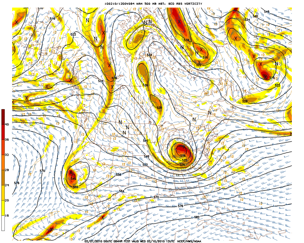
More cold air on the way next week!?
By it or not, here the thinking of the GFS 12Z centered on Wednesday afternoon.
-
sleetstorm
- Posts: 651
- Joined: Thu Feb 04, 2010 12:33 pm
- Contact:
That computer model still merits some attention, in my opinion.wxdata wrote:By it or not, here the thinking of the GFS 12Z centered on Wednesday afternoon.
-
Portastorm

- Posts: 800
- Joined: Wed Feb 03, 2010 3:04 pm
- Location: Southwest Austin/Oak Hill, TX
- Contact:
Well Sleet, as Wxman57 has said on more than one occasion about next week ... none of the modeling can be trusted until Monday or even Tuesday. The normally trusty Euro has had its problems this winter and is, IMHO, no lock. Same with the Canadian.
-
srainhoutx

- Site Admin

- Posts: 19616
- Joined: Tue Feb 02, 2010 2:32 pm
- Location: Maggie Valley, NC
- Contact:
Larry Cosgrove thoughts in the Houston Examiner...
http://www.examiner.com/x-3775-Houston- ... -600-PM-CT
http://www.examiner.com/x-3775-Houston- ... -600-PM-CT
Carla/Alicia/Jerry(In The Eye)/Michelle/Charley/Ivan/Dennis/Katrina/Rita/Wilma/Humberto/Ike/Harvey
Member: National Weather Association
Facebook.com/Weather Infinity
Twitter @WeatherInfinity
Member: National Weather Association
Facebook.com/Weather Infinity
Twitter @WeatherInfinity
-
sleetstorm
- Posts: 651
- Joined: Thu Feb 04, 2010 12:33 pm
- Contact:
What does all of that mean for SE Texas for next week, srainhoutx? I read it and am still somewhat not fully understanding.srainhoutx wrote:Larry Cosgrove thoughts in the Houston Examiner...
http://www.examiner.com/x-3775-Houston- ... -600-PM-CT
-
sleetstorm
- Posts: 651
- Joined: Thu Feb 04, 2010 12:33 pm
- Contact:
I understand, Portastorm. Everyone on this weather forum may very well have wait until nearly the day of the event, if not until the day of the event, simply to see what does in fact transpire, weatherwise. Those computer models are not seeing eye to eye with each other. We have most of them saying with what they are showing us that southeast Texas may only get a cold rain and a few saying with what they are showing us that southeast Texas has a feasibility of receiving sleet/snow/rain snow mix.Portastorm wrote:Well Sleet, as Wxman57 has said on more than one occasion about next week ... none of the modeling can be trusted until Monday or even Tuesday. The normally trusty Euro has had its problems this winter and is, IMHO, no lock. Same with the Canadian.
-
srainhoutx
- Site Admin
- Posts: 19616
- Joined: Tue Feb 02, 2010 2:32 pm
- Location: Maggie Valley, NC
- Contact:
00Z have started. Perhaps the "night crew" will be busy... 
Carla/Alicia/Jerry(In The Eye)/Michelle/Charley/Ivan/Dennis/Katrina/Rita/Wilma/Humberto/Ike/Harvey
Member: National Weather Association
Facebook.com/Weather Infinity
Twitter @WeatherInfinity
Member: National Weather Association
Facebook.com/Weather Infinity
Twitter @WeatherInfinity
-
sleetstorm
- Posts: 651
- Joined: Thu Feb 04, 2010 12:33 pm
- Contact:
What does that mean or could mean for mean for southeast Texas for the middle-late part of next week, srainhoutx 
-
srainhoutx
- Site Admin
- Posts: 19616
- Joined: Tue Feb 02, 2010 2:32 pm
- Location: Maggie Valley, NC
- Contact:
Carla/Alicia/Jerry(In The Eye)/Michelle/Charley/Ivan/Dennis/Katrina/Rita/Wilma/Humberto/Ike/Harvey
Member: National Weather Association
Facebook.com/Weather Infinity
Twitter @WeatherInfinity
Member: National Weather Association
Facebook.com/Weather Infinity
Twitter @WeatherInfinity
-
sleetstorm
- Posts: 651
- Joined: Thu Feb 04, 2010 12:33 pm
- Contact:
Are you saying that southeast Texas is officially out of the game to receive any sleet/rain snow mix during the middle to late part of next week, srainhout? Even though we are more than seventy-two hours out from the actual event itself.
-
srainhoutx
- Site Admin
- Posts: 19616
- Joined: Tue Feb 02, 2010 2:32 pm
- Location: Maggie Valley, NC
- Contact:
Carla/Alicia/Jerry(In The Eye)/Michelle/Charley/Ivan/Dennis/Katrina/Rita/Wilma/Humberto/Ike/Harvey
Member: National Weather Association
Facebook.com/Weather Infinity
Twitter @WeatherInfinity
Member: National Weather Association
Facebook.com/Weather Infinity
Twitter @WeatherInfinity

here we go again......
-
wxman57

- Global Moderator

- Posts: 2621
- Joined: Thu Feb 04, 2010 5:34 am
- Location: Southwest Houston (Westbury)
- Contact:
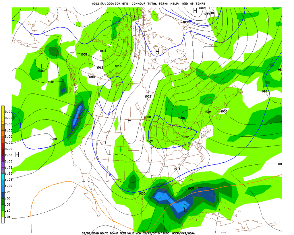
Here's a GFS meteogram from the 00Z run. Looks a bit warmer and drier than previous runs, particularly so compared to the very cold previous 00Z runs. I still don't think it's got it right. But what it says that cold air is initially in place but the development of a low/wave offshore pumps a lot of warmer air inland over the top of it, warming the lower layers to well above freezing during the rain. Mid to upper 30s and rain next Thu/Fri. Great...


It is still a week away. We will get a better idea 3 days before.

IMO- We will NOT have any freezing precip in SouthEast Texas next week. No way. No how.
-
Portastorm
- Posts: 800
- Joined: Wed Feb 03, 2010 3:04 pm
- Location: Southwest Austin/Oak Hill, TX
- Contact:
What are you worried about? You said you don't trust the GFS right now anyhow. Could be 55 and partly cloudy in Houston next Thur/Fri and ideal bike riding weather!wxman57 wrote:Here's a GFS meteogram from the 00Z run. Looks a bit warmer and drier than previous runs, particularly so compared to the very cold previous 00Z runs. I still don't think it's got it right. But what it says that cold air is initially in place but the development of a low/wave offshore pumps a lot of warmer air inland over the top of it, warming the lower layers to well above freezing during the rain. Mid to upper 30s and rain next Thu/Fri. Great...

Sorry, NWS Houston/Galveston isn't seeing any potential for frozen precip around here.
High temperatures for much of the middle of the week will only be
in the 40s with cold advection lasting through Tuesday night. Cloud
cover will be tricky as suspect there will be some lingering
clouds due to trapped moisture in the frontal inversion. This too
will hold down temperatures. The 12z GFS/European model (ecmwf) bring the next trough
into Texas on Thursday. This system will be a forecast challenge to say
the least as the GFS has a rather potent system similar to the
one that pushed through the region this past Thursday. The European model (ecmwf)
is rather weak and slower with the system. For now given such
forecast uncertainty...will leave 30/40 probability of precipitation in the forecast.
Temperatures will resemble those in the previous package but tweaked
with the latest GFS. The forecast leans a bit more on the GFS as
if forecast confidence in a stronger system increases...higher
rain chances will be needed and coastal flooding will become an
issue should another northwest Gulf coastal low develop.
-
biggerbyte
- Posts: 1142
- Joined: Thu Feb 04, 2010 12:15 am
- Location: Porter, Texas. (Montgomery County)
- Contact:
Hmm!
I would view the NWS in much the same way you view long range model forecasting... Theses folks are NOT the place to hang your hat on and call it a day. Let's see what they say come Tuesday/Wednesday.
I would view the NWS in much the same way you view long range model forecasting... Theses folks are NOT the place to hang your hat on and call it a day. Let's see what they say come Tuesday/Wednesday.
Fair enough, but you'd think they'd be somewhat in the general area.biggerbyte wrote:Hmm!
I would view the NWS in much the same way you view long range model forecasting... Theses folks are NOT the place to hang your hat on and call it a day. Let's see what they say come Tuesday/Wednesday.
Who knows........guess we'll know when we know.
-
Portastorm
- Posts: 800
- Joined: Wed Feb 03, 2010 3:04 pm
- Location: Southwest Austin/Oak Hill, TX
- Contact:
Well, I wouldn't mind hanging my hat on MY local NWSFO office as they now have sleet and snow officially in the Austin-area forecast!
.WEDNESDAY...CLOUDY. A 20 PERCENT CHANCE OF RAIN OR SNOW IN THE
AFTERNOON. HIGHS IN THE LOWER 40S.
.WEDNESDAY NIGHT...CLOUDY WITH A 40 PERCENT CHANCE OF RAIN AND
SNOW OR SLEET. LOWS IN THE MID 30S.
.WEDNESDAY...CLOUDY. A 20 PERCENT CHANCE OF RAIN OR SNOW IN THE
AFTERNOON. HIGHS IN THE LOWER 40S.
.WEDNESDAY NIGHT...CLOUDY WITH A 40 PERCENT CHANCE OF RAIN AND
SNOW OR SLEET. LOWS IN THE MID 30S.