
Good Evening from Port Lavaca!! Found yall via Storm2k a few months back. Been lurking, but finally decided to register.
Quick question. Where can I find weather archives for my area? I seem to remember my area being unseasonably warm, with a couple a days of thick seafog a few days before the foot of snow we got 12/04....which is the same kind of weather we had prior to FROPA. I would like to find out if my memory is correct.
February 1-5, 2011 Arctic Blast/Winter Storm Discussion
-
radiogirltx

- Posts: 15
- Joined: Tue Feb 01, 2011 8:52 pm
- Location: Port Lavaca, TX
- Contact:
-
jabcwb2
- Posts: 232
- Joined: Thu Feb 04, 2010 5:43 am
- Location: Houston 77066
- Contact:
Paul wrote:0z NAM 60hrs
700mb
http://www.nco.ncep.noaa.gov/pmb/nwprod ... 0_060l.gif
http://www.nco.ncep.noaa.gov/pmb/nwprod ... p_060l.gif
0z GFS is next up...10:30...
Assuming the green is precipitation, what do the numbers translate to?
-
snowman65

- Posts: 1415
- Joined: Thu Feb 04, 2010 6:39 am
- Location: Orange, Tx
- Contact:
G. Bostwick calling for 40% Thurs and 70% Friday......that's for golden triangle....sure hope that pans out as snow and not freezing rain...
-
Paul

- Posts: 535
- Joined: Wed Feb 03, 2010 11:46 pm
- Location: Pearland
- Contact:
jabcwb2 wrote:Paul wrote:0z NAM 60hrs
700mb
http://www.nco.ncep.noaa.gov/pmb/nwprod ... 0_060l.gif
http://www.nco.ncep.noaa.gov/pmb/nwprod ... p_060l.gif
0z GFS is next up...10:30...
Assuming the green is precipitation, what do the numbers translate to?
that ULL is going right across central Texas pulling up moisture from the GOM and EPAC....means plenty of moisture
-
srainhoutx

- Site Admin

- Posts: 19700
- Joined: Tue Feb 02, 2010 2:32 pm
- Location: Maggie Valley, NC
- Contact:
Welcome radiogirltx. Here is a great place to start...radiogirltx wrote:Good Evening from Port Lavaca!! Found yall via Storm2k a few months back. Been lurking, but finally decided to register.
Quick question. Where can I find weather archives for my area? I seem to remember my area being unseasonably warm, with a couple a days of thick seafog a few days before the foot of snow we got 12/04....which is the same kind of weather we had prior to FROPA. I would like to find out if my memory is correct.
http://lwf.ncdc.noaa.gov/oa/ncdc.html
Carla/Alicia/Jerry(In The Eye)/Michelle/Charley/Ivan/Dennis/Katrina/Rita/Wilma/Humberto/Ike/Harvey
Member: National Weather Association
Facebook.com/Weather Infinity
Twitter @WeatherInfinity
Member: National Weather Association
Facebook.com/Weather Infinity
Twitter @WeatherInfinity
-
jabcwb2
- Posts: 232
- Joined: Thu Feb 04, 2010 5:43 am
- Location: Houston 77066
- Contact:
Thank you for explaining!Paul wrote:jabcwb2 wrote:Paul wrote:0z NAM 60hrs
700mb
http://www.nco.ncep.noaa.gov/pmb/nwprod ... 0_060l.gif
http://www.nco.ncep.noaa.gov/pmb/nwprod ... p_060l.gif
0z GFS is next up...10:30...
Assuming the green is precipitation, what do the numbers translate to?
that ULL is going right across central Texas pulling up moisture from the GOM and EPAC....means plenty of moisture
-
Ptarmigan

- Statistical Specialist

- Posts: 4517
- Joined: Wed Feb 03, 2010 7:20 pm
- Contact:
Geopotential setup for 1960 snow event.Candy Cane wrote:Steve, I'm not sure what you are seeing bud. The second biggest snowfall on record is 4.4" in Feb. 1960. There is potential to break that with this storm at IAH.
http://www.wxresearch.com/snowhou.htm
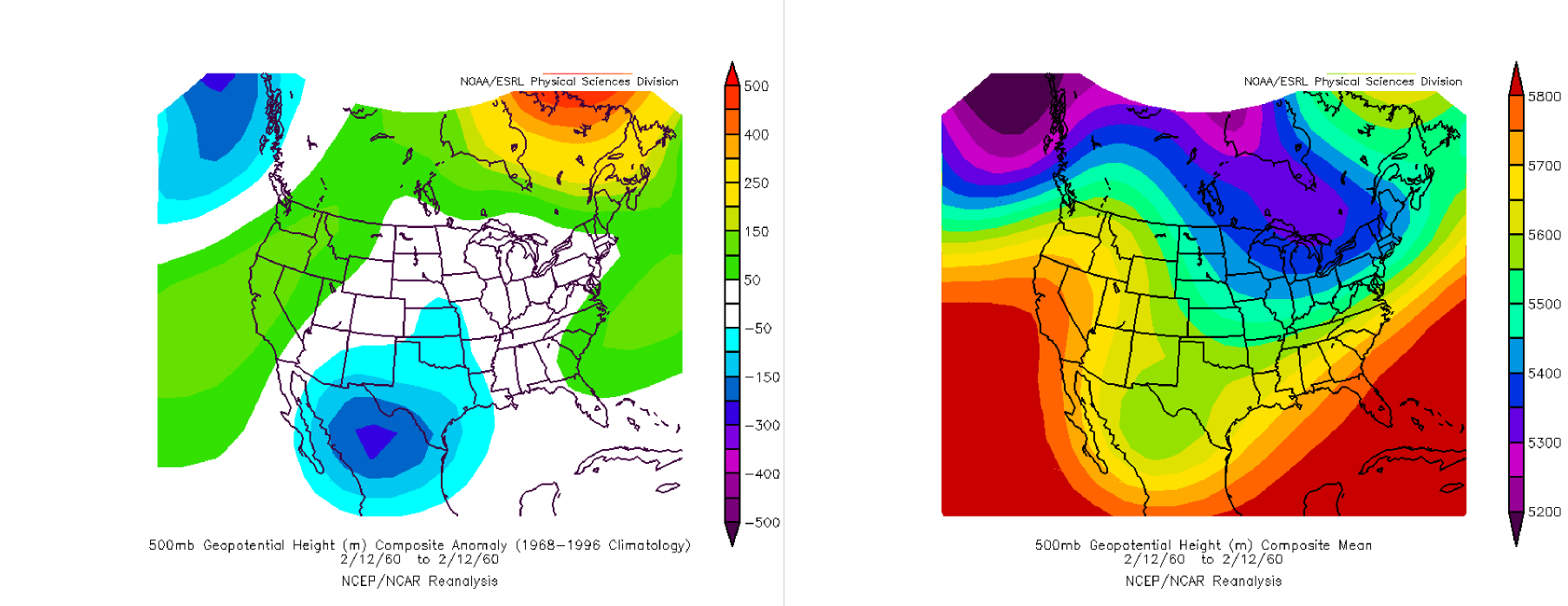
Also, it was not that cold.
2/12/1960-49/30
-
Andrew
- Site Admin
- Posts: 3508
- Joined: Wed Feb 03, 2010 9:46 pm
- Location: North-West Houston
- Contact:
Welcome to the forums. I am sure Ptarmigan can help you out with that question.radiogirltx wrote:Good Evening from Port Lavaca!! Found yall via Storm2k a few months back. Been lurking, but finally decided to register.
Quick question. Where can I find weather archives for my area? I seem to remember my area being unseasonably warm, with a couple a days of thick seafog a few days before the foot of snow we got 12/04....which is the same kind of weather we had prior to FROPA. I would like to find out if my memory is correct.
For Your Infinite Source For All Things Weather Visit Our Facebook
-
Ptarmigan
- Statistical Specialist
- Posts: 4517
- Joined: Wed Feb 03, 2010 7:20 pm
- Contact:
Or you can ask me.radiogirltx wrote:Good Evening from Port Lavaca!! Found yall via Storm2k a few months back. Been lurking, but finally decided to register.
Quick question. Where can I find weather archives for my area? I seem to remember my area being unseasonably warm, with a couple a days of thick seafog a few days before the foot of snow we got 12/04....which is the same kind of weather we had prior to FROPA. I would like to find out if my memory is correct.
http://www7.ncdc.noaa.gov/IPS/coop/coop.html
Last edited by Ptarmigan on Tue Feb 01, 2011 9:35 pm, edited 1 time in total.
-
srainhoutx
- Site Admin
- Posts: 19700
- Joined: Tue Feb 02, 2010 2:32 pm
- Location: Maggie Valley, NC
- Contact:
Paul wrote:jabcwb2 wrote:
Assuming the green is precipitation, what do the numbers translate to?
that ULL is going right across central Texas pulling up moisture from the GOM and EPAC....means plenty of moisture

Carla/Alicia/Jerry(In The Eye)/Michelle/Charley/Ivan/Dennis/Katrina/Rita/Wilma/Humberto/Ike/Harvey
Member: National Weather Association
Facebook.com/Weather Infinity
Twitter @WeatherInfinity
Member: National Weather Association
Facebook.com/Weather Infinity
Twitter @WeatherInfinity
-
Ptarmigan
- Statistical Specialist
- Posts: 4517
- Joined: Wed Feb 03, 2010 7:20 pm
- Contact:
I looked at past snow events and many of them cam from ULL from the west, including the Februry 1895 snow event.srainhoutx wrote:http://weather.unisys.com/satellite/sat ... oop-12.gifPaul wrote:jabcwb2 wrote:
Assuming the green is precipitation, what do the numbers translate to?
that ULL is going right across central Texas pulling up moisture from the GOM and EPAC....means plenty of moisture
-
snowman65
- Posts: 1415
- Joined: Thu Feb 04, 2010 6:39 am
- Location: Orange, Tx
- Contact:
according to the water vapor image, where is this system that's bringing in all the moisture thurs and fri?
-
ticka1
- Posts: 1265
- Joined: Wed Feb 03, 2010 3:02 pm
- Location: Baytown/Mont Belvieu
- Contact:
i asked that question many many pages back!snowman65 wrote:according to the water vapor image, where is this system that's bringing in all the moisture thurs and fri?
-
srainhoutx
- Site Admin
- Posts: 19700
- Joined: Tue Feb 02, 2010 2:32 pm
- Location: Maggie Valley, NC
- Contact:
Diving into the base of the trough in the 4 Corners region. Folks, a very dynamic and interesting pattern developing for the next few days. You see our Pros and NWS is talking this up. In a normal situation, we would not see this frankness.snowman65 wrote:according to the water vapor image, where is this system that's bringing in all the moisture thurs and fri?
Carla/Alicia/Jerry(In The Eye)/Michelle/Charley/Ivan/Dennis/Katrina/Rita/Wilma/Humberto/Ike/Harvey
Member: National Weather Association
Facebook.com/Weather Infinity
Twitter @WeatherInfinity
Member: National Weather Association
Facebook.com/Weather Infinity
Twitter @WeatherInfinity
-
Paul
- Posts: 535
- Joined: Wed Feb 03, 2010 11:46 pm
- Location: Pearland
- Contact:
Patricia let it develope.ticka1 wrote:i asked that question many many pages back!snowman65 wrote:according to the water vapor image, where is this system that's bringing in all the moisture thurs and fri?
-
Paul
- Posts: 535
- Joined: Wed Feb 03, 2010 11:46 pm
- Location: Pearland
- Contact:
srainhoutx wrote:Diving into the base of the trough in the 4 Corners region. Folks, a very dynamic and interesting pattern developing for the next few days. You see our Pros and NWS is talking this up. In a normal situation, we would not see this frankness.snowman65 wrote:according to the water vapor image, where is this system that's bringing in all the moisture thurs and fri?Time for me to hit the hay. Thursday not far away. Welcome new folks and have fun. Nothing would make our buddy wxdata any happier...
agree...once it dives down it will cut off tap the GOM/EPAC and game on.....
-
snowman65
- Posts: 1415
- Joined: Thu Feb 04, 2010 6:39 am
- Location: Orange, Tx
- Contact:
What is meant by a cutoff? What does that create?...thanksPaul wrote:srainhoutx wrote:Diving into the base of the trough in the 4 Corners region. Folks, a very dynamic and interesting pattern developing for the next few days. You see our Pros and NWS is talking this up. In a normal situation, we would not see this frankness.snowman65 wrote:according to the water vapor image, where is this system that's bringing in all the moisture thurs and fri?
agree...once it dives down it will cut off tap the GOM/EPAC and game on.....
-
Andrew
- Site Admin
- Posts: 3508
- Joined: Wed Feb 03, 2010 9:46 pm
- Location: North-West Houston
- Contact:
What is meant by a cutoff? What does that create?...thanks[/quote]Paul wrote:srainhoutx wrote:Diving into the base of the trough in the 4 Corners region. Folks, a very dynamic and interesting pattern developing for the next few days. You see our Pros and NWS is talking this up. In a normal situation, we would not see this frankness.snowman65 wrote:according to the water vapor image, where is this system that's bringing in all the moisture thurs and fri?
agree...once it dives down it will cut off tap the GOM/EPAC and game on.....
A closed low which has become completely displaced (cut off) from basic westerly current, and moves independently of that current. Cutoff lows may remain nearly stationary for days, or on occasion may move westward opposite to the prevailing flow aloft (ie, retrogression).
For Your Infinite Source For All Things Weather Visit Our Facebook
-
ticka1
- Posts: 1265
- Joined: Wed Feb 03, 2010 3:02 pm
- Location: Baytown/Mont Belvieu
- Contact:
i know I know Paul - i just wanted to know where the moisture source was going to be....just taking this one day at a time!Paul wrote:Patricia let it develope.ticka1 wrote:i asked that question many many pages back!snowman65 wrote:according to the water vapor image, where is this system that's bringing in all the moisture thurs and fri?...we are still 48-60hrs out....this will be cutoff ULL and associated trof. We will see it take shape tomorrow night IMO. Way to much model agreement.