

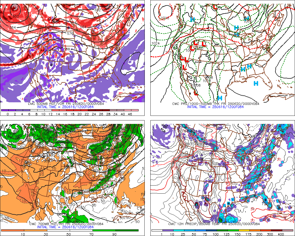
Canadian model looks nice if you want snow around here:
http://www.meteo.psu.edu/ewall/CMC_12z/f84.gif
February Weather Discussion. Wild Winter Storms?
-
tireman4

- Global Moderator

- Posts: 4515
- Joined: Wed Feb 03, 2010 9:24 pm
- Location: Humble, Texas
- Contact:
Wxdata:
Further down the road, very 'interesting' weather possible for Monday week.
Ears perk up....Eh?
Wxman57..I got my 7 mile run this morning. Great times. 51:55 for 7 miles...easy 7:25 pace....
Further down the road, very 'interesting' weather possible for Monday week.
Ears perk up....Eh?
Wxman57..I got my 7 mile run this morning. Great times. 51:55 for 7 miles...easy 7:25 pace....
-
txsnowmaker
- Posts: 632
- Joined: Wed Feb 03, 2010 4:07 pm
- Location: SW Houston (Galleria area)
- Contact:
don wrote:Canadian model looks nice if you want snow around here:
http://www.meteo.psu.edu/ewall/CMC_12z/f84.gif
Thanks don. Since we are only three days out, I will gladly accept any and all forecasts showing snow for Houston.
We've been watching this approaching system for a day or so here in the New Orleans area, but by this morning, we have pretty much given up hope. Good luck to you folks in the Houston area for one more shot. You can have the snow this time, we'll take the Super Bowl! 

Both GFS and ECMWF show strong upper system swinging through the state late next weekend. If valid, it should at least bring a chance of severe weather into the state by late Sunday/Monday of next week...tireman4 wrote:Wxdata:
Further down the road, very 'interesting' weather possible for Monday week.
Ears perk up....Eh?
-
TexasMetBlake
- Pro Met

- Posts: 839
- Joined: Wed Feb 03, 2010 7:03 pm
- Location: Spring/Woodlands
- Contact:
12z gfs is rather chintzy with the snow for us...
http://wxcaster.com/gis-gfs-snow-overla ... TIONID=HGX
http://wxcaster.com/gis-gfs-snow-overla ... TIONID=HGX
-
TexasMetBlake
- Pro Met
- Posts: 839
- Joined: Wed Feb 03, 2010 7:03 pm
- Location: Spring/Woodlands
- Contact:
Actually it does show snow atleast for areas north of I-10 maybe not the southern half of southeast Texas but the northern half does look adequate for atleast a little snow.Ed Mahmoud wrote:Canadian shows little or no snow for Houston. The freezing 850 mb isotherm passes Houston about Hour 90, and that is when the precip ends. Look at Hour 96.
http://www.meteo.psu.edu/~gadomski/CMC_12z/f96.gif
No 6 hour precip...
-
biggerbyte
- Posts: 1142
- Joined: Thu Feb 04, 2010 12:15 am
- Location: Porter, Texas. (Montgomery County)
- Contact:
don wrote:Actually it does show snow atleast for areas north of I-10 maybe not the southern half of southeast Texas but the northern half does look adequate for atleast a little snow.Ed Mahmoud wrote:Canadian shows little or no snow for Houston. The freezing 850 mb isotherm passes Houston about Hour 90, and that is when the precip ends. Look at Hour 96.
http://www.meteo.psu.edu/~gadomski/CMC_12z/f96.gif
No 6 hour precip...
Ed, did we miss breakfast today????
What are ya looking at? Folks north of I10 do have a shot at this.

Wow! Now the 12z CMC and Euro are on board with some snow in the Houston area! Nice!
I'm starting to get that itchy feelin'
I'm starting to get that itchy feelin'
BTW, thank you very much for the welcomed model analysis, wxman57. I'm sure we all appreciate the graphs and explanations you have been posting this morning.
Lets hope we all get to see some white stuff in the air tuesday... If we could just see some snow falling again this winter, I will be happy. Any accumulation will be a bonus!
Lets hope we all get to see some white stuff in the air tuesday... If we could just see some snow falling again this winter, I will be happy. Any accumulation will be a bonus!
-
srainhoutx

- Site Admin

- Posts: 19619
- Joined: Tue Feb 02, 2010 2:32 pm
- Location: Maggie Valley, NC
- Contact:
Just looked at some newer data coming in. Areas from the Big Country in W TX to just N of I-10 and points E look 'real interesting' at this range.
Carla/Alicia/Jerry(In The Eye)/Michelle/Charley/Ivan/Dennis/Katrina/Rita/Wilma/Humberto/Ike/Harvey
Member: National Weather Association
Facebook.com/Weather Infinity
Twitter @WeatherInfinity
Member: National Weather Association
Facebook.com/Weather Infinity
Twitter @WeatherInfinity
-
srainhoutx
- Site Admin
- Posts: 19619
- Joined: Tue Feb 02, 2010 2:32 pm
- Location: Maggie Valley, NC
- Contact:
I posted no links Ed. Just my thoughts.Ed Mahmoud wrote:You need a box with the words "URL=" around the underline tages. Oh, and a URL.srainhoutx wrote:Just looked at some newer data coming in. Areas from the Big Country in W TX to just N of I-10 and points E look 'real interesting' at this range.
Carla/Alicia/Jerry(In The Eye)/Michelle/Charley/Ivan/Dennis/Katrina/Rita/Wilma/Humberto/Ike/Harvey
Member: National Weather Association
Facebook.com/Weather Infinity
Twitter @WeatherInfinity
Member: National Weather Association
Facebook.com/Weather Infinity
Twitter @WeatherInfinity
-
srainhoutx
- Site Admin
- Posts: 19619
- Joined: Tue Feb 02, 2010 2:32 pm
- Location: Maggie Valley, NC
- Contact:
From Dallas/Ft Worth... the important part of the AFD...
ONCE THIS SYSTEM PASSES...COLD ARCTIC AIR WILL SPREAD ACROSS NORTH
TEXAS SUNDAY NIGHT AND MONDAY...AND REMAIN IN PLACE THROUGH MID
WEEK. THERE IS ANOTHER UPPER TROUGH OVER THE NORTHERN ROCKIES
TODAY THAT WILL ELONGATE WEST-EAST BEFORE MOVING SOUTHEAST INTO
NORTH TEXAS ON TUESDAY. FORECAST NORTH TEXAS SOUNDINGS CONTINUE TO
INDICATE GOOD SNOWFALL POTENTIAL WITH FAVORABLE DENDRITIC GROWTH
ZONE TEMPERATURES. HOWEVER...AS STATED BY THE PREVIOUS SHIFT...LOW
LEVEL WINDS FIELDS WILL BE NORTHERLY WITH THIS SYSTEM AND WILL
LIMIT THE AMOUNT OF MOISTURE FOR HEAVY SNOWFALL. ALSO THE
TEMPERATURE PROFILE NEAR THE SURFACE WILL BE MID 30S WHERE THE
SNOW POTENTIAL IS GREATEST. HAVE GONE WITH A SNOW/RAIN MIX SOUTH
OF A GOLDTHWAITE TO ATHENS LINE ON TUESDAY AFTERNOON...OTHERWISE
JUST SNOW ELSEWHERE WITH LITTLE NORTH OF I-20. BECAUSE OF THE
POTENTIAL FOR RAIN MIXED IN WITH THE SNOW OVER THE SOUTHERN
HALF... SNOWFALL AMOUNTS ARE VERY HARD TO PREDICT...THUS EXPECT
SEVERAL INCHES IN SOME AREAS SOUTH OF COMANCHE TO HILLSBORO LINE.
THIS WILL BE REFINED OVER THE NEXT SEVERAL DAYS AS THE PATH OF THE
SYSTEM BECOMES CLEARER. NO WINTER STORM OUTLOOK WILL BE ISSUED AT
THIS TIME AS WE THINK SNOWFALL AMOUNTS WILL NOT EXCEED WARNING
CRITERIA (4" OR MORE IN 12HRS).
Carla/Alicia/Jerry(In The Eye)/Michelle/Charley/Ivan/Dennis/Katrina/Rita/Wilma/Humberto/Ike/Harvey
Member: National Weather Association
Facebook.com/Weather Infinity
Twitter @WeatherInfinity
Member: National Weather Association
Facebook.com/Weather Infinity
Twitter @WeatherInfinity
-
biggerbyte
- Posts: 1142
- Joined: Thu Feb 04, 2010 12:15 am
- Location: Porter, Texas. (Montgomery County)
- Contact:
Ed Mahmoud wrote:If the Canadian does not show much snow at my house, than "North of I-10" gives little comfort.
I actually live North of I-10, a bit, but careful staring at 850 mb happiness line, and where my house is in relation to Galveston Bay, looks like little to no precip at my house.
Although, with Mom, younger brother, two sisters and inlaws/nieces/nephews in the Metroplex, I can get some remote joy from Canadian snow.
And, of course, still have a few days for the Happy 850 mb Isotherm to drift a few miles farther South. But we need either cold surface temps or decent precip rates, or both. Late February sun angle, even through clouds, is a killer. The potentially happy news is a good part of this should happen at night, when sun angle probably doesn't matter much.
I know how you feel, Ed. Even though we can be happy for the fortunate, we are still left with this "left out" feeling. I remember some folks talking about the big snow they had in December and wondering why that could not be happening in Porter.
So even with a glass 2/3rds empty, I maintain 1/3rd full optimism (cautious, guarded, but optimism) on local happiness.
A small climate "did you know":
If we reach 70 degrees tommorow, which we probably will, it will be the first 70 degree day this month. This is absolutely incredible, when you consider that our average high at this time is 68. I know. Doesn't seem like it, does it? The average high reaches 70 on the last day of the month.
If we do reach 70 degrees tommorow, we probably will not for the rest of the month. An extended look at GFS ensembles and the Euro would indicate continued chilly conditions to begin March.
-
TexasMetBlake
- Pro Met
- Posts: 839
- Joined: Wed Feb 03, 2010 7:03 pm
- Location: Spring/Woodlands
- Contact:
Dallas Thoughts:
THERE IS ANOTHER UPPER TROUGH OVER THE NORTHERN ROCKIES
TODAY THAT WILL ELONGATE WEST-EAST BEFORE MOVING SOUTHEAST INTO
NORTH TEXAS ON TUESDAY. FORECAST NORTH TEXAS SOUNDINGS CONTINUE TO
INDICATE GOOD SNOWFALL POTENTIAL WITH FAVORABLE DENDRITIC GROWTH
ZONE TEMPERATURES. HOWEVER...AS STATED BY THE PREVIOUS SHIFT...LOW
LEVEL WINDS FIELDS WILL BE NORTHERLY WITH THIS SYSTEM AND WILL
LIMIT THE AMOUNT OF MOISTURE FOR HEAVY SNOWFALL. ALSO THE
TEMPERATURE PROFILE NEAR THE SURFACE WILL BE MID 30S WHERE THE
SNOW POTENTIAL IS GREATEST. HAVE GONE WITH A SNOW/RAIN MIX SOUTH
OF A GOLDTHWAITE TO ATHENS LINE ON TUESDAY AFTERNOON...OTHERWISE
JUST SNOW ELSEWHERE WITH LITTLE NORTH OF I-20. BECAUSE OF THE
POTENTIAL FOR RAIN MIXED IN WITH THE SNOW OVER THE SOUTHERN
HALF... SNOWFALL AMOUNTS ARE VERY HARD TO PREDICT...THUS EXPECT
SEVERAL INCHES IN SOME AREAS SOUTH OF COMANCHE TO HILLSBORO LINE.
THIS WILL BE REFINED OVER THE NEXT SEVERAL DAYS AS THE PATH OF THE
SYSTEM BECOMES CLEARER. NO WINTER STORM OUTLOOK WILL BE ISSUED AT
THIS TIME AS WE THINK SNOWFALL AMOUNTS WILL NOT EXCEED WARNING
CRITERIA (4" OR MORE IN 12HRS).
-
srainhoutx
- Site Admin
- Posts: 19619
- Joined: Tue Feb 02, 2010 2:32 pm
- Location: Maggie Valley, NC
- Contact:
San Angelo thoughts...very good disco in the AFD...to go along with what CC posted...
.LONG TERM...
THE CURRENT BLOCKING PATTERN IN PLACE OVER THE EASTERN PACIFIC
INTO WESTERN CANADA WILL NOT HANG ON MUCH LONGER. OVER THE NEXT
SEVERAL DAYS...THE RIDGE WILL BREAK DOWN AND ALLOW THE NEARLY
CUTOFF DOWNSTREAM SYSTEM OVER THE NW CONUS TO DROP SOUTHEAST
ACROSS TX ON TUESDAY. ONCE THE RIDGE BREAKS DOWN...THE PACIFIC
WAVE TRAIN WILL BECOME ACTIVE AGAIN TOWARD THE END OF THE
WEEK...LIKE IT HAS BEEN MUCH OF THIS WINTER.
A NEARLY STATIONARY FRONTAL BOUNDARY CURRENTLY RESIDES JUST TO THE
NORTH OF THE SAN ANGELO WFO AREA OF RESPONSIBILITY (CWA). THIS
BOUNDARY WILL STAY TO OUR NORTH UNTIL THE PASSAGE OF A SMALL...BUT
POTENT SOUTHERN STREAM WAVE CURRENTLY OVER SOUTHERN AZ. THE FRONT
WILL PUSH SOUTH ACROSS W CENTRAL TX LATE SUNDAY INTO SUNDAY NIGHT.
AS A RESULT...THE WORK WEEK WILL START OFF ON THE COOL SIDE WITH
BELOW AVERAGE TEMPS AREA WIDE.
MONDAY NIGHT INTO TUESDAY...A POTENT NORTHERN STREAM TROUGH WILL
DIVE SOUTHEAST ACROSS THE SOUTH CENTRAL STATES WITH A POSITIVE
TILT...WHICH WILL CONTINUE TO ALLOW COLDER AIR TO FILTER IN THE
REGION. STRONG MID LEVEL COLD FRONTOGENETIC FORCING IN THE RIGHT
ENTRANCE REGION OF THE POLAR JET WILL PRODUCE A BAND OF
PRECIPITATION THAT WILL SWEEP GENERALLY NW TO SE ACROSS THE CWA
LATE MONDAY NIGHT INTO TUESDAY. WHILE THE INITIAL PRECIP MAY BE IN
THE FORM OF RAIN OR A MIX OF RAIN AND SNOW...THE PRECIP SHOULD
QUICKLY CHANGE OVER TO ALL SNOW WITH BOTH THE GFS/ECMWF SHOWING
850MB TEMPS IN THE -2C TO -4C RANGE. ACCUMULATING SNOW IS A
POSSIBILITY EVEN WITH THE WARM GROUND...GIVEN THAT SNOW MAY BE
HEAVY AT TIMES WITH STRONG...BUT NARROW FORCING AND SOME HINT OF
CONDITIONAL SYMMETRIC INSTABILITY (CSI) PRESENT TO INCREASE
SNOWFALL RATES. IT IS STILL TOO EARLY TO TELL HOW MUCH SNOW WILL
FALL AND WHERE...SO WILL CONTINUE THE SPS THAT WE HAVE GOING.
FORCING FOR ASCENT WILL SHIFT RAPIDLY SOUTHEAST BY TUESDAY EVENING
AND THE SNOW WILL TAPER OFF.
Carla/Alicia/Jerry(In The Eye)/Michelle/Charley/Ivan/Dennis/Katrina/Rita/Wilma/Humberto/Ike/Harvey
Member: National Weather Association
Facebook.com/Weather Infinity
Twitter @WeatherInfinity
Member: National Weather Association
Facebook.com/Weather Infinity
Twitter @WeatherInfinity
-
TexasMetBlake
- Pro Met
- Posts: 839
- Joined: Wed Feb 03, 2010 7:03 pm
- Location: Spring/Woodlands
- Contact:
Austin: (hardly enthusiastic)
A COOLER AIRMASS WILL FILTER SOUTHWARD ACROSS SOUTH CENTRAL TEXAS
ON MONDAY WITH THE PASSAGE OF THE SHORT WAVE TROF. A MUCH STRONGER
UPPER LEVEL TROF IN THE NORTHERN STREAM WILL MOVE ACROSS OUR REGION
ON TUESDAY. THIS FEATURE WILL DRAW A COLDER CONTINENTAL AIRMASS
SOUTHWARD MAKING FOR A WET AND CHILLY DAY ON TUESDAY. OVERRUNNING
MOISTURE WILL ACCOMPANY THIS FEATURE. THIS WILL RESULT IN A COLD RAIN
STARTING MONDAY NIGHT ACROSS THE HILL COUNTRY AND EDWARDS PLATEAU.
SPREADING SOUTH AND EAST ON TUESDAY. THE RAIN WILL BECOME MIXED
WITH SNOW AT TIMES...WITH THE RAIN/SNOW MIX LINE DROPPING SOUTHWARD
TO HIGHWAY 90 TUESDAY EVENING. THE PCPN WILL END ACROSS OUR SOUTHEAST
COUNTIES WEDNESDAY MORNING. NO SNOW ACCUMULATIONS ARE EXPECTED WITH
THIS WEATHER SYSTEM.
-
TexasMetBlake
- Pro Met
- Posts: 839
- Joined: Wed Feb 03, 2010 7:03 pm
- Location: Spring/Woodlands
- Contact:
Shreveport: They Mention WSW May Be Needed
MODEL RUNS CONCERNING TUESDAY/S POTENTIAL SNOW LOOK SIMILAR TO
YESTERDAY/S...WITH THE EXCEPTION OF THE EURO LOOKING A LITTLE
DRIER. MODELS ARE STILL INDICATING PLENTY OF COLD AIR FOR
SNOW MAKING...SO REALLY THE ONLY QUESTION IS WHETHER THERE WILL BE
ENOUGH MOISTURE AVAILABLE TO SUPPORT THE QPF THAT THE GFS IS
FORECASTING. AT ANY RATE...STILL HAVE A COUPLE MORE MODEL RUNS TO
LOOK AT BEFORE WE HAVE TO CHOOSE SIDES...AND HAVE KEPT POPS BELOW
GUIDANCE ACCORDINGLY. HOWEVER...IF MODELS CONTINUE TO TREND TOWARDS A
SIGNIFICANT SNOWFALL...A WINTER STORM WATCH MAY BE NEEDED.