
May 2025
-
Cpv17
- Posts: 7091
- Joined: Fri Aug 31, 2018 1:58 pm
- Location: El Campo/Wharton
- Contact:
Just picked up .35” here. Was surprised we even got that.
-
DoctorMu

- Posts: 8030
- Joined: Sun Jun 28, 2015 11:58 am
- Location: College Station
- Contact:
The lower temps have been nice. Only 0.2 inches from round 1, though. Need another round. A full pint this time!
-
BAY29
- Posts: 31
- Joined: Sat Mar 08, 2025 6:05 pm
- Contact:
3/4 of an inch here in Tomball! Round 2 is gonna help even more
-
don

- Posts: 3148
- Joined: Wed Feb 03, 2010 3:33 pm
- Location: Wichita Falls
- Contact:
I think the next MCS will hold up better for yall than the one today did. It will be "younger" when it moves into SE Texas as it's developing further south in the state compared to the last several MCS's.

-
tireman4

- Global Moderator

- Posts: 7127
- Joined: Wed Feb 03, 2010 9:24 pm
- Location: Humble, Texas
- Contact:
From Jeff ( via Facebook)
Next round of storms will develop into a complex and approach/move into the area early Tuesday likely before sunrise. A severe wind threat will be possible with this activity
Next round of storms will develop into a complex and approach/move into the area early Tuesday likely before sunrise. A severe wind threat will be possible with this activity
- Attachments
-
- img_2_1748298745082.jpg
- (235.17 KiB) Downloaded 5219 times
-
Cpv17
- Posts: 7091
- Joined: Fri Aug 31, 2018 1:58 pm
- Location: El Campo/Wharton
- Contact:
I’m hoping that it holds together better than what the HRRR is depicting. It shows it weakening somewhat upon approach.
-
Cpv17
- Posts: 7091
- Joined: Fri Aug 31, 2018 1:58 pm
- Location: El Campo/Wharton
- Contact:
That is one nasty storm just a few miles south of Mason.
-
Cpv17
- Posts: 7091
- Joined: Fri Aug 31, 2018 1:58 pm
- Location: El Campo/Wharton
- Contact:
A large and violent tornado was confirmed just a few miles south of Mason. Headed towards Fredicksburg now.
-
tireman4
- Global Moderator
- Posts: 7127
- Joined: Wed Feb 03, 2010 9:24 pm
- Location: Humble, Texas
- Contact:
Radar
- Attachments
-
- KEWX_loop.gif (627.95 KiB) Viewed 11878 times
-
DoctorMu
- Posts: 8030
- Joined: Sun Jun 28, 2015 11:58 am
- Location: College Station
- Contact:
-
Cpv17
- Posts: 7091
- Joined: Fri Aug 31, 2018 1:58 pm
- Location: El Campo/Wharton
- Contact:
The HRRR has now sped up the MCS. It’s now looking to push through the area between 12-3am. That’s actually better if you want more rain.
-
Cromagnum
- Posts: 3065
- Joined: Thu Feb 03, 2011 10:42 pm
- Location: Georgetown
- Contact:
Quite a burst of wind as this mess blew in. At least 80mph at my house. Likely 100+ north of here towards Florence.
-
Stratton20
- Posts: 5818
- Joined: Tue Feb 09, 2021 11:35 pm
- Location: College Station, Texas
- Contact:
Man thats a really nasty MCS out near the hill country, got some wind gusts up in the 80-90 mph range in some of the severe warned cells, hopefully the line weakens as it approaches se texas
-
Cpv17
- Posts: 7091
- Joined: Fri Aug 31, 2018 1:58 pm
- Location: El Campo/Wharton
- Contact:
The earlier it arrives, the stronger it’ll be.Stratton20 wrote: ↑Mon May 26, 2025 9:08 pm Man thats a really nasty MCS out near the hill country, got some wind gusts up in the 80-90 mph range in some of the severe warned cells, hopefully the line weakens as it approaches se texas
-
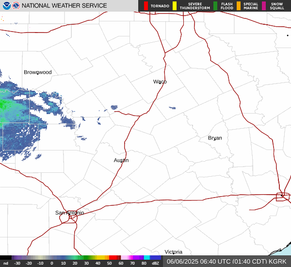
tireman4
- Global Moderator
- Posts: 7127
- Joined: Wed Feb 03, 2010 9:24 pm
- Location: Humble, Texas
- Contact:
Radar
- Attachments
-
- KGRK_loop.gif (1.04 MiB) Viewed 11770 times
-
Cpv17
- Posts: 7091
- Joined: Fri Aug 31, 2018 1:58 pm
- Location: El Campo/Wharton
- Contact:
Severe thunderstorm watch just issued for SE TX till 5am.
-
tireman4
- Global Moderator
- Posts: 7127
- Joined: Wed Feb 03, 2010 9:24 pm
- Location: Humble, Texas
- Contact:
-
DoctorMu
- Posts: 8030
- Joined: Sun Jun 28, 2015 11:58 am
- Location: College Station
- Contact:
This MCS is not losing strength yet. We're starting to hear thunder.
-
Rip76

- Posts: 2128
- Joined: Mon Feb 15, 2010 12:38 am
- Location: The Woodlands
- Contact:
Still holding.
-
Stratton20
- Posts: 5818
- Joined: Tue Feb 09, 2021 11:35 pm
- Location: College Station, Texas
- Contact:
Think the worst of the winds will stay north of I-10, at least it appears the strongest cells will stay to the north of the metro, the line will pack a punch though, nothing too crazy hopefully