
2024 Hurricane Season Discussion
-
Stratton20
- Posts: 5870
- Joined: Tue Feb 09, 2021 11:35 pm
- Location: College Station, Texas
- Contact:
Cpv17 I disagree largely, number of storms, sure it was a bust, but in terms of US impacts, definitely a devastating season for many
-
Cpv17
- Posts: 7109
- Joined: Fri Aug 31, 2018 1:58 pm
- Location: El Campo/Wharton
- Contact:
I’m talking about number of storms bro.Stratton20 wrote: ↑Sat Oct 26, 2024 1:41 pm Cpv17 I disagree largely, number of storms, sure it was a bust, but in terms of US impacts, definitely a devastating season for many
-
Stratton20
- Posts: 5870
- Joined: Tue Feb 09, 2021 11:35 pm
- Location: College Station, Texas
- Contact:
Cpv17 i know, i said i agree the number of storms forecast were a bust, but i think its difficult to say the season was a bust considering the land impacts were severe for sure , this one is hard to say bust or not, but i for once am glad the numbers did not verify, lol, bust for numbers, but definitely not a bust for impacts,
-
Cpv17
- Posts: 7109
- Joined: Fri Aug 31, 2018 1:58 pm
- Location: El Campo/Wharton
- Contact:
I think only 3 storms had U.S. impacts. That ain’t very much. Plus I look at number of storms to determine if a season is bust or not, not really land impacts. This season was hyped up to be historic. It was nowhere near that. Therefore it’s a bust to me.Stratton20 wrote: ↑Sat Oct 26, 2024 2:59 pm Cpv17 i know, i said i agree the number of storms forecast were a bust, but i think its difficult to say the season was a bust considering the land impacts were severe for sure , this one is hard to say bust or not, but i for once am glad the numbers did not verify, lol, bust for numbers, but definitely not a bust for impacts,
-
tireman4

- Global Moderator

- Posts: 7161
- Joined: Wed Feb 03, 2010 9:24 pm
- Location: Humble, Texas
- Contact:
Headlines
Tropical development odds are close to 50/50 in the Caribbean over the next week.
Initially, if anything develops, it is unlikely to move a whole lot, rather just sitting over the Caribbean.
Eventually, we may see a slow west or west-northwest movement.
Interests from Central America through the Caribbean should monitor updates on this.
Apologies for the lack of post yesterday, but I was preoccupied with some other things most of the day. Let's get into things this morning.
The NHC gives the western and central Caribbean about a 40 percent chance of development over the next week.
Eyes on the western or central Caribbean
Development odds are officially up to about 40 percent now in the Caribbean over the next week, as it appears we will enter a somewhat more active period in the tropics for November. The first thing I think we can say with some confidence this week is that this is not going to be a quick process. If this develops into an organized tropical system, it will take its time. The most likely outcome is that whatever forms here is likely to kind of fester for several days before trying to develop. We can sort of see the beginnings of stuff over the Caribbean this morning.
Far from organization, what we have in the Caribbean are a couple "blobs" of thunderstorms around the periphery. Over time, we'll see a slow focus toward more storms in the central or wester Caribbean.
We've got nascent thunderstorms all around the periphery of the Caribbean right now. But over time, we will probably see more thunderstorms focus themselves in the central or western Caribbean. This is what could fester its way into development this weekend or early next week.
What will probably end up happening is over the next week or so, we see this begin to pop up and fester in the Caribbean. Heading into the late weekend, high pressure over Florida and the Gulf and a second high pressure system just east of the islands will impart opposite movement on the disturbance, which basically cancels out. The steering currents shift to near zero. In other words, what starts to develop in the Caribbean will be unlikely to move a whole lot initially.
A map of the situation about 20,000 feet up on Sunday. Whatever tries to form in the Caribbean will likely only move very slowly, if much at all.
Over time, high pressure in the Gulf will probably stay in place, while high pressure east of the islands weakens. This may allow for a very slow northwest or west movement within the Caribbean next week. Exactly what this means is somewhat unclear at this point but we have several days to watch this. I don't believe we will see any marked organization of anything until at least Sunday or Monday. For now at least, I would not be too worried about this in the United States, but interests from Central America across the Caribbean should be checking back in with their sources every day or two for updates on this. We will obviously keep watching.
More to come tomorrow.
Beyond this area, there is not a whole lot to focus on at this point.
-
tireman4
- Global Moderator
- Posts: 7161
- Joined: Wed Feb 03, 2010 9:24 pm
- Location: Humble, Texas
- Contact:
Tropical Weather Outlook
NWS National Hurricane Center Miami FL
800 AM EDT Wed Oct 30 2024
For the North Atlantic...Caribbean Sea and the Gulf of Mexico:
Southwestern Caribbean Sea:
A broad area of low pressure is likely to develop over the
southwestern Caribbean Sea in a couple of days. Gradual development
is possible thereafter, and a tropical depression could form over
the weekend or early next week while the system drifts generally
northward over the central or western Caribbean Sea.
* Formation chance through 48 hours...low...near 0 percent.
* Formation chance through 7 days...medium...40 percent.
$$
Forecaster Beven
-
DoctorMu

- Posts: 8089
- Joined: Sun Jun 28, 2015 11:58 am
- Location: College Station
- Contact:
GFS and CMC have one more TS in the incubator and released into the GOM in 7-10 days.tireman4 wrote: ↑Wed Oct 30, 2024 8:57 am Tropical Weather Outlook
NWS National Hurricane Center Miami FL
800 AM EDT Wed Oct 30 2024
For the North Atlantic...Caribbean Sea and the Gulf of Mexico:
Southwestern Caribbean Sea:
A broad area of low pressure is likely to develop over the
southwestern Caribbean Sea in a couple of days. Gradual development
is possible thereafter, and a tropical depression could form over
the weekend or early next week while the system drifts generally
northward over the central or western Caribbean Sea.
* Formation chance through 48 hours...low...near 0 percent.
* Formation chance through 7 days...medium...40 percent.
$$
Forecaster Beven
-
Stratton20
- Posts: 5870
- Joined: Tue Feb 09, 2021 11:35 pm
- Location: College Station, Texas
- Contact:
Probably wont end up being a big deal, upper level shear is very hostile in the gulf, anything that tries to head toward the gulf is going to get absolutely obliterated by that shear
-
tireman4
- Global Moderator
- Posts: 7161
- Joined: Wed Feb 03, 2010 9:24 pm
- Location: Humble, Texas
- Contact:
The Eyewall
By Matt Lanza
Headlines
Development odds are increasing in the Caribbean.
Slow development is possible in about 3 to 5 days with a slow west or northwest movement.
Interests in Central America, Mexico, Cuba, Jamaica, and the Caymans should continue to monitor development closely.
U.S. impact risks remain quite low due to cooler water in the Gulf and wind shear.
Caribbean development odds inching up
The system that could develop in the Caribbean over the next several days is up to 60 percent today, as the forecast continues to look a touch more bullish on development.
The NHC is slowly boosting odds of development in the Caribbean today.
Back on Tuesday, we noted that it would probably move north or west from where it gets going, and today the NHC basically says the same thing. The upper pattern is favoring something a little anomalous for November, as most often, systems will move north or northeast from the Caribbean this time of year.
Anyway, we have at least loose model agreement almost across the board today that something should get going in the western or west-central Caribbean in about 3 to 5 days. In fact, looking at the Euro ensemble, we can see a clear development signal in the Caribbean by Sunday.
European ensemble on board with tropical development in about 3 to 4 days, much like most other modeling.
There will be a number of factors in play that will impact the strength and track of this system. First off, notice that there is also a low pressure signal on the north side of Cuba or Hispaniola. That low-probability system could have an impact on how shear impacts the Caribbean disturbance. Initially, high pressure over Florida and the eastern Gulf will likely help steer this system slightly to the west. Over time, that high pressure system may shift east a bit to focus more over Florida or the Bahamas. This could open the door to more of a northwest or northerly motion into the Gulf from this system.
The upper air pattern will favor a westerly and perhaps eventually a northwesterly motion to this system in the Caribbean.
You may look at that outcome and say, “Oh no, here we go again.” But the situation in November is generally much different than that of October. While the Gulf is generally warmer than normal, it has cooled a good deal in the last month.
The Gulf has cooled off a good deal over the last 30 days.
So we aren’t dealing with the precursor setup that we were with Helene or Milton. Secondly, wind shear tends to be quite aggressive in November. The forecast of wind shear in the northern and western Gulf is quite significant next week, with high shear in those locations.
A lot of wind shear separates a potential disturbance in the southern Gulf or northwest Caribbean from the U.S. Mainland.
That said, any kind of development is worth noting, particularly for folks in Mexico (the Yucatan), Cuba, Jamaica, or the Cayman Islands. And I would encourage those areas to watch this system closely, especially given that the Caribbean remains very warm and has barely cooled off in the last 30 days. For folks in the U.S., this is unlikely to cause major heartburn, but it probably remains worth watching at least until we have a better sense of how things will unfold. For now, it remains nothing of serious concern for the Gulf Coast.
More this weekend.
-
tireman4
- Global Moderator
- Posts: 7161
- Joined: Wed Feb 03, 2010 9:24 pm
- Location: Humble, Texas
- Contact:
The Eyewall
Caribbean system set to try and form this weekend or next week and another wave causes flash flooding in Puerto Rico
By Matt Lanza on November 1, 2024
Headlines
We are getting a clearer picture of the Caribbean development potential this weekend and next week, with a disturbance possibly developing as it approaches Jamaica from the south Sunday or Monday.
From there, it should turn west or west-northwest, threatening Cuba, the Cayman Islands, and perhaps the Yucatan as a tropical system.
As it likely tracks into the Gulf next week, it will encounter hostile wind shear that should weaken it considerably.
A tropical wave is also producing heavy rain and flash flooding in Puerto Rico.
Caribbean system starting to come into better focus
Our potential system in the Caribbean continues to see support grow for its organization. The NHC is up to 70 percent odds this morning, and it's possible those increase further today.
Disorganized thunderstorms continue to percolate in the Caribbean, with development odds increasing this weekend or early next week. (Weathernerds.org)
Thunderstorms remain broad and disorganized today in this region, so I think we've got at least a couple days before anything happens here. Modeling seems to agree that a piece of the Central American Gyre (CAG) will break off north of Panama tomorrow and track generally northward toward Jamaica. I doubt we'll see rapid development here, but it is possible that by Monday, we have a depression or something close to that near Jamaica.
The Euro ensemble is in agreement on a possible system near Jamaica on Monday evening.
This is good model support, though the details and specifics are always tricky. But support from the ensembles and most operational guidance now exists on this as the most likely outcome through Monday evening. From this point, the system will likely begin to be steered by high pressure anchored over Florida. This should turn it northwest and then possibly due west toward the Yucatan. This will be the timeframe that is most critical in terms of potential impacts for Cuba, the Cayman Islands and Mexico. Most modeling keeps the system in check, only strengthening it a bit, but there are a handful of models that are aggressively intensifying this as it comes northwest.
The Euro ensemble is in good agreement on a track that places it broadly between Cuba and the Yucatan next Wednesday.
By next Wednesday, we should have a tropical system somewhere between Belize and Cuba. From here, the future track of this system becomes uncertain. High pressure should allow the system to keep going west or west-northwest into the Gulf of Mexico. But by late next week, assuming it starts to turn more northerly, it's going to get hammered by wind shear. So even if it does come northward toward the central or eastern Gulf of Mexico, it is likely going to deal with November headwinds which should keep its intensity in check. So, for now, we continue to suspect that this won't be a big concern for the U.S. Gulf Coast. But you should check back in later this weekend or early next week just to make sure. For areas between Belize and Jamaica, including Cuba, this will be a system to watch closely through the weekend. We'll keep you posted.
Elsewhere: Flooding in Puerto Rico
The NHC is highlighting two other areas, one north of the islands and one near the Azores. Neither has much more than a 10 to 20 percent chance of development and none are a serious concern, although heavy rain in Puerto Rico has been causing flash flooding concerns, and additional rain will continue to cause flash flooding in the eastern and northern portions of the island.
Puerto Rico is under threat from heavy rain and flash flooding through tonight as a robust tropical wave passes.
Most of this should hopefully ease up over the weekend.
-
Pas_Bon
- Posts: 968
- Joined: Tue Sep 11, 2018 7:58 am
- Location: League City, TX
- Contact:
Guys and gals…..go ahead and play peek-a-boo with the item in the NW Caribbean at the end of the 00z GFS (11/19).
Hint: it isn’t Rafael.
Hint: it isn’t Rafael.
-
Cpv17
- Posts: 7109
- Joined: Fri Aug 31, 2018 1:58 pm
- Location: El Campo/Wharton
- Contact:
Are we sure it’s November? This is flat bizarre:
-
tireman4
- Global Moderator
- Posts: 7161
- Joined: Wed Feb 03, 2010 9:24 pm
- Location: Humble, Texas
- Contact:
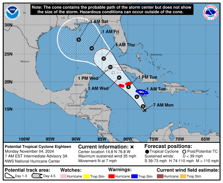
Eric Berger
Space Center Weather
Tropics
I cannot believe we’re talking about the tropics in early November, but here we are. The National Hurricane Center has highlighted an area in the Caribbean Sea as a potential tropical cyclone, and if this system develops (which is likely) it will become named Rafael. At first glance, the forecast track might appear to be fairly concerning for Texas, with a tropical storm in the middle of the Gulf of Mexico by this weekend.
Official forecast for PTC 18. (National Hurricane Center)
There is a lot of uncertainty over this system’s track over the next week. However, if the storm does make it to the central Gulf, it will find fairly robust wind shear and dry air, which should inhibit strengthening. It would be historically unprecedented to have a tropical storm make it to Texas at this time of year, and much of the modeling guidance keeps the storm away, so it’s doubtful we have much to worry about. My sense is that we may see some higher seas by this weekend offshore, but probably not too many other impacts. Regardless, we’ll be watching closely and keeping you updated.
-
Ptarmigan

- Statistical Specialist

- Posts: 4536
- Joined: Wed Feb 03, 2010 7:20 pm
- Contact:
Texas has been hit by hurricanes in November. Last happened in 1839.
https://www.weather.gov/media/lch/event ... istory.pdf
https://www.weather.gov/media/lch/event ... istory.pdf
-
Cromagnum
- Posts: 3076
- Joined: Thu Feb 03, 2011 10:42 pm
- Location: Georgetown
- Contact:

-
Cpv17
- Posts: 7109
- Joined: Fri Aug 31, 2018 1:58 pm
- Location: El Campo/Wharton
- Contact:
It’s amazing how you can find this stuff.Ptarmigan wrote: ↑Mon Nov 04, 2024 9:15 pm Texas has been hit by hurricanes in November. Last happened in 1839.
https://www.weather.gov/media/lch/event ... istory.pdf
-
tireman4
- Global Moderator
- Posts: 7161
- Joined: Wed Feb 03, 2010 9:24 pm
- Location: Humble, Texas
- Contact:
000
WTNT33 KNHC 051146
TCPAT3
BULLETIN
Tropical Storm Rafael Intermediate Advisory Number 7A
NWS National Hurricane Center Miami FL AL182024
700 AM EST Tue Nov 05 2024
...RAFAEL PASSING SOUTHWEST OF JAMAICA...
SUMMARY OF 700 AM EST...1200 UTC...INFORMATION
----------------------------------------------
LOCATION...17.4N 78.4W
ABOUT 80 MI...130 KM SSW OF MONTEGO BAY JAMAICA
ABOUT 230 MI...370 KM SE OF GRAND CAYMAN
MAXIMUM SUSTAINED WINDS...60 MPH...95 KM/H
PRESENT MOVEMENT...NW OR 325 DEGREES AT 13 MPH...20 KM/H
MINIMUM CENTRAL PRESSURE...993 MB...29.33 INCHES
WATCHES AND WARNINGS
--------------------
CHANGES WITH THIS ADVISORY:
None.
SUMMARY OF WATCHES AND WARNINGS IN EFFECT:
A Hurricane Warning is in effect for...
* Cayman Islands
* Cuban provinces of Pinar del Rio, Artemisa, La Habana, Mayabeque,
Matanzas, and the Isle of Youth
A Tropical Storm Warning is in effect for...
* Jamaica
* Cuban provinces of Villa Clara, Cienfuegos, Sancti Spiritus,
and Ciego de Avila
A Tropical Storm Watch is in effect for...
* Cuban provinces of Camaguey and Las Tunas
* Lower and Middle Florida Keys from Key West to west of the Channel
5 Bridge
* Dry Tortugas
A Hurricane Warning means that hurricane conditions are expected
somewhere within the warning area. A warning is typically issued 36
hours before the anticipated first occurrence of
tropical-storm-force winds, conditions that make outside
preparations difficult or dangerous. Preparations to protect life
and property should be rushed to completion.
A Tropical Storm Warning means that tropical storm conditions are
expected somewhere within the warning area.
A Tropical Storm Watch means that tropical storm conditions are
possible within the watch area, generally within 48 hours.
Interests elsewhere in Cuba should closely monitor this system.
For storm information specific to your area in the United
States, including possible inland watches and warnings, please
monitor products issued by your local National Weather Service
forecast office. For storm information specific to your area
outside of the United States, please monitor products issued by
your national meteorological service.
DISCUSSION AND OUTLOOK
----------------------
At 700 AM EST (1200 UTC), the center of Tropical Storm Rafael was
located near latitude 17.4 North, longitude 78.4 West. Rafael is
moving toward the northwest near 13 mph (20 km/h). A generally
northwestward motion is anticipated over the next few days. On the
forecast track, the storm is expected to move near Jamaica this
morning, be near or over the Cayman Islands tonight, and be near or
over western Cuba on Wednesday.
Maximum sustained winds are near 60 mph (95 km/h) with higher gusts.
Steady to rapid intensification is forecast over the next 24 to 36
hours, and Rafael is forecast to become a hurricane in the
northwestern Caribbean near the Cayman Islands with further
strengthening before it makes landfall in Cuba.
Tropical-storm-force winds extend outward up to 105 miles (165 km)
from the center.
The estimated minimum central pressure is 993 mb (29.33 inches).
HAZARDS AFFECTING LAND
----------------------
Key messages for Tropical Storm Rafael can be found in the
Tropical Cyclone Discussion under AWIPS header MIATCDAT3 and WMO
header WTNT43 KNHC and on the web at
hurricanes.gov/text/MIATCDAT3.shtml
WIND: Hurricane conditions are expected in the Cayman Islands by
this afternoon and are also expected in western Cuba and the Isle
of Youth on Wednesday. Tropical storm conditions are expected in
Jamaica through early this afternoon and are expected in parts of
west-central Cuba, possible farther east in central Cuba, and in
the lower and middle Florida Keys on Wednesday.
RAINFALL: Heavy rainfall will impact areas of the Western Caribbean
through early Thursday, particularly across Jamaica and the Cayman
Islands into southern and western portions of Cuba where rainfall
totals between 3 to 6 inches are expected. Isolated higher totals up
to 10 inches are anticipated across the higher terrain in Jamaica
and Cuba, which could lead to areas of flash flooding and mudslides.
Heavy rainfall will spread north into Florida and adjacent areas of
the Southeast United States during the middle to latter part of the
week. Rainfall totals of 1 to 3 inches are expected for the Lower
and Middle Florida Keys.
For a complete depiction of forecast rainfall associated with
Tropical Storm Rafael, please see the National Weather Service Storm
Total Rainfall Graphic, available at
www.nhc.noaa.gov/graphics_at3.shtml?rainqpf
STORM SURGE: Minor coastal flooding is possible in Jamaica tonight.
Storm surge could raise water levels by 1 to 3 feet above normal
tide levels in the Cayman Islands on Tuesday, and could raise water
levels by as much as 6 to 9 feet above normal tide levels in areas
of onshore winds along the southern coast of Cuba in the Hurricane
Warning area, including the Isle of Youth.
The combination of a storm surge and the tide will cause normally
dry areas near the coast to be flooded by rising waters moving
inland from the shoreline. The water could reach the following
heights above ground somewhere in the indicated areas if the peak
surge occurs at the time of high tide...
Dry Tortugas...1-3 ft
Lower Florida Keys...1-2 ft
TORNADOES: A few tornadoes are possible Wednesday over the Keys and
southwesternmost Florida mainland.
SURF: Swells generated by Rafael are expected to affect much of
the western Caribbean during the next few days. These swells are
likely to cause life-threatening surf and rip current conditions.
Please consult products from your local weather office.
NEXT ADVISORY
-------------
Next complete advisory at 1000 AM EST.
$$
Forecaster Beven
-
tireman4
- Global Moderator
- Posts: 7161
- Joined: Wed Feb 03, 2010 9:24 pm
- Location: Humble, Texas
- Contact:
00
WTNT43 KNHC 050854
TCDAT3
Tropical Storm Rafael Discussion Number 7
NWS National Hurricane Center Miami FL AL182024
400 AM EST Tue Nov 05 2024
Satellite imagery shows that Rafael is becoming better organized,
with convective banding features becoming more prominent,
especially over the eastern semicircle of the circulation. Central
convection is still a bit limited at this time, with a rather small
Central Dense Overcast. An earlier Air Force Hurricane Hunter
mission indicated falling central pressure, with maximum winds
approaching 50 kt. The current intensity is set at that value,
which is slightly above the subjective Dvorak estimates, based on
the increasing organization of the system. Another Air Force
Hurricane Hunter aircraft will investigate Rafael a little later
this morning which should provide a good estimate on the strength of
the tropical cyclone.
Rafael is moving northwestward, with an initial motion estimate of
about 325/11 kt. The tropical cyclone should continue this general
motion for the next couple of days, crossing western Cuba and
moving into the southeastern Gulf of Mexico. The track guidance is
in fairly good agreement for the first 48 hours of the period.
Thereafter, the model tracks diverge with an increasing spread
between the GFS and ECMWF solutions with time. The ECMWF
simulation shows a much stronger mid-level ridge over the
southeastern U.S., resulting in Rafael moving into the western Gulf
in the latter part of the period. In contrast, the GFS model
indicates that ridge will break down in 3-4 days, allowing the
system to turn northward. The official forecast lies roughly
between these two possibilities and is fairly close to the model
consensus. This is just slightly west of the previous NHC track.
Given the model spread, there is a less confidence than usual in the
4-5 day forecast.
The storm is currently situated in an atmospheric and oceanic
environment that is quite conducive for strengthening, with high
oceanic heat content, low vertical wind shear, and high low- to
mid-tropospheric humidity. The various Rapid Intensification (RI)
indices from our model guidance show a significant chance of RI
during the next day or so, so the shorter-term official intensity
forecast might be a bit conservative. After Rafael moves into the
Gulf of Mexico, however, drier air and stronger vertical wind shear
should halt the strengthening process. The official intensity
forecast is on the high side of the guidance for the 3-5 day
forecast, and is similar to the previous NHC prediction.
Key Messages:
1. Rafael is forecast to be near hurricane intensity when it passes
near or over the Cayman Islands by tonight where damaging
hurricane-force winds, a dangerous storm surge, and destructive
waves are expected. Rafael should reach western Cuba and the Isle of
Youth on Wednesday. A hurricane warning is in effect for this
region, where a dangerous storm surge and destructive waves are
also expected.
2. Tropical storm conditions are expected in Jamaica through early
this afternoon. Tropical storm conditions are possible in the
Lower and Middle Florida Keys beginning late Wednesday or Wednesday
night.
3. It is too soon to determine what, if any, impacts Rafael could
bring to portions of the northern Gulf Coast. Residents in this
area should regularly monitor updates to the forecast.
4. Rafael will bring areas of heavy rain across portions of the
Western Caribbean through early Thursday, including the islands of
Jamaica and the Caymans, along with southern and western portions of
Cuba. Flash flooding and mudslides are possible along the higher
terrain in Jamaica and Cuba. Heavy rainfall will spread north into
Florida and adjacent areas of the Southeast United States mid to
late week.
FORECAST POSITIONS AND MAX WINDS
INIT 05/0900Z 17.0N 78.0W 50 KT 60 MPH
12H 05/1800Z 18.4N 79.2W 60 KT 70 MPH
24H 06/0600Z 20.3N 80.8W 70 KT 80 MPH
36H 06/1800Z 22.2N 82.5W 80 KT 90 MPH
48H 07/0600Z 23.9N 84.0W 80 KT 90 MPH
60H 07/1800Z 25.0N 85.3W 80 KT 90 MPH
72H 08/0600Z 25.8N 86.5W 75 KT 85 MPH
96H 09/0600Z 26.8N 89.0W 60 KT 70 MPH
120H 10/0600Z 27.8N 90.6W 45 KT 50 MPH
$$
Forecaster Pasch
-
tireman4
- Global Moderator
- Posts: 7161
- Joined: Wed Feb 03, 2010 9:24 pm
- Location: Humble, Texas
- Contact:
BULLETIN
Tropical Storm Rafael Advisory Number 9
NWS National Hurricane Center Miami FL AL182024
400 PM EST Tue Nov 05 2024
...RAFAEL STRENGTHENING AS IT HEADS TOWARDS THE CAYMAN ISLANDS...
SUMMARY OF 400 PM EST...2100 UTC...INFORMATION
----------------------------------------------
LOCATION...19.1N 79.6W
ABOUT 105 MI...170 KM E OF GRAND CAYMAN
ABOUT 120 MI...190 KM WNW OF MONTEGO BAY JAMAICA
MAXIMUM SUSTAINED WINDS...70 MPH...110 KM/H
PRESENT MOVEMENT...NW OR 325 DEGREES AT 15 MPH...24 KM/H
MINIMUM CENTRAL PRESSURE...989 MB...29.21 INCHES
Tropical Storm Rafael Discussion Number 9
NWS National Hurricane Center Miami FL AL182024
400 PM EST Tue Nov 05 2024
Reports from an Air Force Reserve Hurricane Hunter aircraft and
radar data from Grand Cayman indicate that Rafael has developed an
inner wind core during the past several hours. The radar data shows
the development of a ragged eye, and the Hurricane Hunter reported
850-mb flight-level winds of 73 kt about 30-35 n mi northeast of the
center. The aircraft also reported that the central pressure has
fallen to near 989 mb. Based on these data, the initial intensity
is increased to 60 kt. The wind radii have been revised some based
on the aircraft data.
The initial motion is northwestward at 325/13 kt. Rafael is
currently on the southwestern side of a low- to mid-level ridge over
the western Atlantic, and this feature should steer the cyclone
generally northwestward for the next 36-48 h, with the center
passing near the Cayman Islands and over western Cuba. From 48-72
h, the models are in better agreement that the center should turn
more westward as the ridge builds a little westward along the
northern Gulf coast. After 72 h, there remains some significant
spread in the track guidance, due partly to differences in how fast
Rafael will shear apart and due partly to differences in the
forecast strength of the ridge along the Gulf coast. The GFS
weakens the ridge and shows a northward turn, while the ECMWF keeps
a stronger ridge and shows a more westward motion. The
deterministic UKMET has now changed to a northward turn scenario,
but the HWRF, HMON, and UKMET ensemble mean join the ECMWF with a
westward motion. As mentioned with the previous forecast, until
there is a clearer signal on which of these scenarios is more
likely, the forecast compromises between these extremes with a slow
turn toward the north over the northern Gulf of Mexico.
Now that Rafael has developed an inner wind core, conditions are
favorable for steady to rapid strengthening during the next 24 h or
so. The system is expected to reach hurricane strength during
the next several hours as it passes through the Cayman Islands with
additional strengthening before it reaches Cuba. While the peak
intensity forecast is near the high end of the intensity guidance,
there is a chance that Rafael could get stronger than currently
forecast. Once the center is north of 25N in the Gulf of Mexico,
the cyclone is likely to encounter increasing vertical wind shear,
dry air entrainment, and cooler sea surface temperatures, which
should lead to Rafael weakening and eventually shearing apart
vertically. This part of the intensity forecast lies near or just
above the intensity consensus.
Key Messages:
1. Rafael is forecast to be a hurricane when it passes near or over
the Cayman Islands during the next 12 hours, where damaging
hurricane-force winds, a dangerous storm surge, and destructive
waves are expected. Additional strengthening is expected before
Rafael reaches western Cuba and the Isle of Youth on Wednesday. A
hurricane warning is in effect for this region, where damaging
hurricane-force winds, life-threatening storm surge, and destructive
waves are also expected.
2. Tropical storm conditions are expected in the Lower and Middle
Florida Keys beginning Wednesday and Wednesday night.
3. It is too soon to determine what, if any, impacts Rafael could
bring to portions of the northern Gulf Coast. Residents in this
area should regularly monitor updates to the forecast.
4. Rafael will bring areas of heavy rain across portions of the
western Caribbean through early Thursday, including Jamaica and the
Cayman Islands, along with southern and western portions of Cuba.
Flash flooding and mudslides are possible along the higher terrain
in Jamaica and Cuba.
FORECAST POSITIONS AND MAX WINDS
INIT 05/2100Z 19.1N 79.6W 60 KT 70 MPH
12H 06/0600Z 20.5N 80.7W 70 KT 80 MPH
24H 06/1800Z 22.5N 82.4W 80 KT 90 MPH
36H 07/0600Z 24.1N 83.8W 80 KT 90 MPH
48H 07/1800Z 25.0N 85.2W 80 KT 90 MPH
60H 08/0600Z 25.4N 86.5W 75 KT 85 MPH
72H 08/1800Z 25.8N 87.8W 65 KT 75 MPH
96H 09/1800Z 27.1N 90.1W 50 KT 60 MPH
120H 10/1800Z 28.8N 90.7W 40 KT 45 MPH
$$
Forecaster Beven
-
tireman4
- Global Moderator
- Posts: 7161
- Joined: Wed Feb 03, 2010 9:24 pm
- Location: Humble, Texas
- Contact:
Rafael...11 05 24
- Attachments
-
- Tropical Storm Raphael 11 05 24.jpg (183.1 KiB) Viewed 33069 times