
June 2024

Ended up getting 2.60" from the thunderstorm. BTW the 0Z CMC and 12Z EURO now also have support for TC development from the underrated ICON. FWIW
- wx.PNG (384.26 KiB) Viewed 2810 times
The 6/11 GFS 00Z Run is a very wet run for the Gulf of Mexico and the Gulf Coast States. It even has a 29.97-inch bullseye total along the Louisiana/Mississippi border. Be mindful that these totals will shift around as we draw closer to the moisture surge/possible tropical development....
- GFS TOTAL QPF - 6.27.2024 00Z RUN.png (983.63 KiB) Viewed 2799 times
-
Stratton20
- Posts: 5439
- Joined: Tue Feb 09, 2021 11:35 pm
- Location: College Station, Texas
- Contact:
Even though its too early to speculate rain fall totals and location, that kind of a atmospheric setup with a fire house of deep rich tropical moisture and a slow moving wave has the potential for a major rainfall event somewhere, interesting week ahead of us
869MB wrote: ↑Tue Jun 11, 2024 1:31 am The 6/11 GFS 00Z Run is a very wet run for the Gulf of Mexico and the Gulf Coast States. It even has a 29.97-inch bullseye total along the Louisiana/Mississippi border. Be mindful that these totals will shift around as we draw closer to the moisture surge/possible tropical development....
GFS TOTAL QPF - 6.27.2024 00Z RUN.png


-
tireman4

- Global Moderator

- Posts: 6292
- Joined: Wed Feb 03, 2010 9:24 pm
- Location: Humble, Texas
- Contact:
473
FXUS64 KHGX 111158
AFDHGX
Area Forecast Discussion
National Weather Service Houston/Galveston TX
658 AM CDT Tue Jun 11 2024
...New AVIATION...
.SYNOPSIS...
Issued at 353 AM CDT Tue Jun 11 2024
It is full out summer here in Southeast Texas, in pretty much all
the ways. We`ve got hot and humid conditions near, or at times
above, seasonal averages. We`ve also got multiple days that will
give us rounds of scattered showers and thunderstorms. And while
this will not be particularly out of the ordinary for most of the
area, those (un)lucky few that get the strongest storms will see
some threat for a greater impact from these storms. A few points
on the week or so:
- There is a marginal risk for severe weather (level 1 of 5) or
for excessive rain (level 1 of 4) today and tomorrow for much of
the area, but particularly west of the Houston metro.
- The end of the week, Friday and Saturday, will see the rain
potential largely turned off, but also looks hotter than average
for mid-June.
- Finally, we`ll see the return of daily shower and storm
potential return Sunday into early next week.
&&
.SHORT TERM...
(Today through Wednesday Night)
Issued at 353 AM CDT Tue Jun 11 2024
Elevated rain chances will continue today through tomorrow as this
wet pattern remains in place across SE TX. The weak frontal bound-
ary that was just north of us yesterday did manage to sink down in
to the CWA last night. And with this feature progged to linger in/
around the region today and tomorrow, it should act as a focus for
additional rounds of showers/thunderstorms. Fueled by PWs in the 2
to 2.2" range, daytime heating, leftover boundaries, possible sea/
bay breezes...coverage today should be a bit more widespread (than
yesterday). Rainfall totals will still average from one half to 1"
with higher totals from 1"-3" possible in the stronger storms. SPC
does have NW/W portions of the CWA (Brazos Valley down to I-10) in
a Marginal Risk for severe weather this afternoon (level 1 of 5).
Should we see any strong/severe development move in from the west,
strong winds and hail will be primary risks.
As we head into tonight, we`re still on the lookout to the W/NW as
models continue to indicate the approach/passage of an MCS (or its
remnants) during the overnight hours into Wed morning. What`s left
of this feature will then be added to the mix (see above for other
ingredients) for tomorrow. So, all of this will be favorable for a
chance excessive rainfall for both today and tomorrow. The WPC ERO
for Days 1 and 2 do have much of SE TX in a Marginal Risk (level 1
of 4). This is mainly due to the increased soil saturation via all
the previous rains and progged efficiency of these storms.
Temperatures will continue to be tempered by the increased clouds/
storms through the short-term. Highs will range from the lower and
mid 90s today and tomorrow. Overnight lows will run from the lower
to mid 70s for most locations...near 80 along the immediate coast.
&&
.LONG TERM...
(Thursday through Monday)
Issued at 353 AM CDT Tue Jun 11 2024
A lot of the long term portion of the forecast boils down
to..."it`s summer" so enjoy! But, that`s not the entirety of the
forecast, and if you`ve noticed who`s writing this discussion,
you`d know I wouldn`t let things go that easily, so let`s dive
into the more interesting nuances that do exist from Thursday
onward.
First up, Thursday. Even though the rain chances aren`t terribly
high, they will be the highest until late in the weekend and early
next week. The primary ridging still looks to be west of us, and
there are indications that the shortwave trough that is expected
to fuel scattered showers and storms on Wednesday won`t be totally
cleared out for Thursday. Because of this, I have slight chance
PoPs going into the day.
Friday and Saturday look to be the hottest days of the period as
mid-level ridging builds eastward from the Desert Southwest.
Ensemble mean 850 mb temps are still largely/entirely below the
90th percentile, so I`m not anticipating a big blow of heat here.
But, the added subsidence and sunny sky look to be enough to push
highs from mainly the lower 90s into mainly the middle 90s. This
should also be enough to push peak heat index values into triple
digits across the area, and boost the threat levels of heat stress
indicated by the wet bulb globe temperature from a mix of
"moderate" and "high" (levels 3 and 4 of 5) risk to widespread
"high" risk. This is largely in keeping with a scenario we would
expect for a couple days on the warm side of a typical mid-June
day in SE Texas.
Sunday looks to be a transition day as the mid-level ridge splits
over Texas, with higher heights over NW Mexico and over the SE US,
leaving our area in a relative weakness in the ridge. Along with
this, a warm, moist, Gulf airmass looks to push its way back into
the area. You will probably be unsurprised to see that I bring
PoPs back in, as we go from a mostly dry/isolated updrafts at most
type of forecast to higher PoPs and anticipating more scattered
showers and storms, particularly for the coastal half of the
area...roughly along the coastal plain and Houston metro towards
the Gulf. How widespread the day`s showers and storms are could
pose interesting heat potential. Dealing with an airmass with
deeper moisture through the column, dewpoints will struggle more
to mix out in the afternoon, and could make for heat index values
pushing up towards 110 if there`s not enough cooling from rain to
tamp the temperatures down.
Going into the new week, rain potential won`t be going anywhere.
That weakness in the ridge stays put, and down in the Bay of
Campeche, a mid-level trough makes its way in. This sets us up
for a continued, unsettled pattern with at least scattered showers
and thunderstorms about the area. Now...I don`t want to put too
much attention on this because this is a weekish out, but yes...we
will want to keep an eye out on what happens over the Gulf in
this timeframe. There are some boxes checked - 200 mb
temps/heights are abnormally high implying an anticyclone at high
levels, and we could see something driving the spinup of a
surface low between that mid-level trough and/or this continued
stalled boundary. Both the deterministic Euro and GFS hint
at...something...low pressurey in this time frame.
So, *could* something tropical come out of this mess? Yeah,
sure, absolutely. It`s hurricane season, and I sure don`t trust
boundaries hanging out over the Gulf for a while in hurricane
season. The important question is "*will* something tropical come
out of this mess?" Pfft, with this messy of a setup and broad
guidance envelope, you`re not catching me committing to *anything*
beyond some higher chances of rain and increased tides from
onshore flow at this range. This is starting to bleed into NHC`s 7
day outlook, and there is not anything of note there, and with
good reason. That is a paradigm y`all can roll with right now.
Keep listening to us and NHC, and we`ll let you know if anything
changes on this front (potentially literally).
&&
.AVIATION...
(12Z TAF Issuance)
Issued at 633 AM CDT Tue Jun 11 2024
Will be expecting another active day today (and possibly extending
into this evening) with a quasi-stationary front as the main focus
for this activity. SH/TSRA are already starting just off the coast
this morning and will be pushing inland this morning...with devel-
opment picking up along the weak front by the early afternoon over
locations further inland. The unsettled weather could persist into
this evening with the approach/passage of an MCS from the W/NW (or
its remnants). Have included the mention of VCSH into the evening/
nighttime hours for most terminals, as well as keeping VCTS in for
this afternoon. 41
&&
.MARINE...
Issued at 353 AM CDT Tue Jun 11 2024
Generally light to moderate onshore flow and low seas should
prevail through the end of the week. There will be a daily risk of
isolated to scattered showers and thunderstorms. Isolated stronger
storms capable of locally higher winds and seas cannot be ruled
out.
At the shore, the lighter winds will result in seas that - while
above astronomical tide levels alone - are expected to stay around
or below 2 feet above MLLW and unlikely to cause disruptive
impacts. The lighter onshore winds also will limit risk of
dangerous rip currents, but not eliminate the risk entirely.
&&
.PRELIMINARY POINT TEMPS/POPS...
College Station (CLL) 90 73 88 72 / 50 20 30 0
Houston (IAH) 92 74 90 74 / 50 40 40 10
Galveston (GLS) 88 80 87 79 / 20 40 40 20
&&
.HGX WATCHES/WARNINGS/ADVISORIES...
TX...None.
GM...None.
&&
$$
SHORT TERM...41
LONG TERM....Luchs
AVIATION...41
MARINE...Luchs

Euro throws 2 tropical systems (weak) at Texas next week and the weak after.Cromagnum wrote: ↑Tue Jun 11, 2024 7:43 am869MB wrote: ↑Tue Jun 11, 2024 1:31 am The 6/11 GFS 00Z Run is a very wet run for the Gulf of Mexico and the Gulf Coast States. It even has a 29.97-inch bullseye total along the Louisiana/Mississippi border. Be mindful that these totals will shift around as we draw closer to the moisture surge/possible tropical development....
GFS TOTAL QPF - 6.27.2024 00Z RUN.png
Precision in when, where, how much will need time...but the GoM is open for business.
tireman4 wrote: ↑Tue Jun 11, 2024 8:11 am 473
FXUS64 KHGX 111158
AFDHGX
Area Forecast Discussion
National Weather Service Houston/Galveston TX
658 AM CDT Tue Jun 11 2024
...New AVIATION...
.SYNOPSIS...
Issued at 353 AM CDT Tue Jun 11 2024
It is full out summer here in Southeast Texas, in pretty much all
the ways. We`ve got hot and humid conditions near, or at times
above, seasonal averages. We`ve also got multiple days that will
give us rounds of scattered showers and thunderstorms. And while
this will not be particularly out of the ordinary for most of the
area, those (un)lucky few that get the strongest storms will see
some threat for a greater impact from these storms. A few points
on the week or so:
- There is a marginal risk for severe weather (level 1 of 5) or
for excessive rain (level 1 of 4) today and tomorrow for much of
the area, but particularly west of the Houston metro.
- The end of the week, Friday and Saturday, will see the rain
potential largely turned off, but also looks hotter than average
for mid-June.
- Finally, we`ll see the return of daily shower and storm
potential return Sunday into early next week.
&&
.SHORT TERM...
(Today through Wednesday Night)
Issued at 353 AM CDT Tue Jun 11 2024
Elevated rain chances will continue today through tomorrow as this
wet pattern remains in place across SE TX. The weak frontal bound-
ary that was just north of us yesterday did manage to sink down in
to the CWA last night. And with this feature progged to linger in/
around the region today and tomorrow, it should act as a focus for
additional rounds of showers/thunderstorms. Fueled by PWs in the 2
to 2.2" range, daytime heating, leftover boundaries, possible sea/
bay breezes...coverage today should be a bit more widespread (than
yesterday). Rainfall totals will still average from one half to 1"
with higher totals from 1"-3" possible in the stronger storms. SPC
does have NW/W portions of the CWA (Brazos Valley down to I-10) in
a Marginal Risk for severe weather this afternoon (level 1 of 5).
Should we see any strong/severe development move in from the west,
strong winds and hail will be primary risks.
As we head into tonight, we`re still on the lookout to the W/NW as
models continue to indicate the approach/passage of an MCS (or its
remnants) during the overnight hours into Wed morning. What`s left
of this feature will then be added to the mix (see above for other
ingredients) for tomorrow. So, all of this will be favorable for a
chance excessive rainfall for both today and tomorrow. The WPC ERO
for Days 1 and 2 do have much of SE TX in a Marginal Risk (level 1
of 4). This is mainly due to the increased soil saturation via all
the previous rains and progged efficiency of these storms.
Temperatures will continue to be tempered by the increased clouds/
storms through the short-term. Highs will range from the lower and
mid 90s today and tomorrow. Overnight lows will run from the lower
to mid 70s for most locations...near 80 along the immediate coast.
&&
.LONG TERM...
(Thursday through Monday)
Issued at 353 AM CDT Tue Jun 11 2024
A lot of the long term portion of the forecast boils down
to..."it`s summer" so enjoy! But, that`s not the entirety of the
forecast, and if you`ve noticed who`s writing this discussion,
you`d know I wouldn`t let things go that easily, so let`s dive
into the more interesting nuances that do exist from Thursday
onward.
First up, Thursday. Even though the rain chances aren`t terribly
high, they will be the highest until late in the weekend and early
next week. The primary ridging still looks to be west of us, and
there are indications that the shortwave trough that is expected
to fuel scattered showers and storms on Wednesday won`t be totally
cleared out for Thursday. Because of this, I have slight chance
PoPs going into the day.
Friday and Saturday look to be the hottest days of the period as
mid-level ridging builds eastward from the Desert Southwest.
Ensemble mean 850 mb temps are still largely/entirely below the
90th percentile, so I`m not anticipating a big blow of heat here.
But, the added subsidence and sunny sky look to be enough to push
highs from mainly the lower 90s into mainly the middle 90s. This
should also be enough to push peak heat index values into triple
digits across the area, and boost the threat levels of heat stress
indicated by the wet bulb globe temperature from a mix of
"moderate" and "high" (levels 3 and 4 of 5) risk to widespread
"high" risk. This is largely in keeping with a scenario we would
expect for a couple days on the warm side of a typical mid-June
day in SE Texas.
Sunday looks to be a transition day as the mid-level ridge splits
over Texas, with higher heights over NW Mexico and over the SE US,
leaving our area in a relative weakness in the ridge. Along with
this, a warm, moist, Gulf airmass looks to push its way back into
the area. You will probably be unsurprised to see that I bring
PoPs back in, as we go from a mostly dry/isolated updrafts at most
type of forecast to higher PoPs and anticipating more scattered
showers and storms, particularly for the coastal half of the
area...roughly along the coastal plain and Houston metro towards
the Gulf. How widespread the day`s showers and storms are could
pose interesting heat potential. Dealing with an airmass with
deeper moisture through the column, dewpoints will struggle more
to mix out in the afternoon, and could make for heat index values
pushing up towards 110 if there`s not enough cooling from rain to
tamp the temperatures down.
Going into the new week, rain potential won`t be going anywhere.
That weakness in the ridge stays put, and down in the Bay of
Campeche, a mid-level trough makes its way in. This sets us up
for a continued, unsettled pattern with at least scattered showers
and thunderstorms about the area. Now...I don`t want to put too
much attention on this because this is a weekish out, but yes...we
will want to keep an eye out on what happens over the Gulf in
this timeframe. There are some boxes checked - 200 mb
temps/heights are abnormally high implying an anticyclone at high
levels, and we could see something driving the spinup of a
surface low between that mid-level trough and/or this continued
stalled boundary. Both the deterministic Euro and GFS hint
at...something...low pressurey in this time frame.
So, *could* something tropical come out of this mess? Yeah,
sure, absolutely. It`s hurricane season, and I sure don`t trust
boundaries hanging out over the Gulf for a while in hurricane
season. The important question is "*will* something tropical come
out of this mess?" Pfft, with this messy of a setup and broad
guidance envelope, you`re not catching me committing to *anything*
beyond some higher chances of rain and increased tides from
onshore flow at this range. This is starting to bleed into NHC`s 7
day outlook, and there is not anything of note there, and with
good reason. That is a paradigm y`all can roll with right now.
Keep listening to us and NHC, and we`ll let you know if anything
changes on this front (potentially literally).
&&
.AVIATION...
(12Z TAF Issuance)
Issued at 633 AM CDT Tue Jun 11 2024
Will be expecting another active day today (and possibly extending
into this evening) with a quasi-stationary front as the main focus
for this activity. SH/TSRA are already starting just off the coast
this morning and will be pushing inland this morning...with devel-
opment picking up along the weak front by the early afternoon over
locations further inland. The unsettled weather could persist into
this evening with the approach/passage of an MCS from the W/NW (or
its remnants). Have included the mention of VCSH into the evening/
nighttime hours for most terminals, as well as keeping VCTS in for
this afternoon. 41
&&
.MARINE...
Issued at 353 AM CDT Tue Jun 11 2024
Generally light to moderate onshore flow and low seas should
prevail through the end of the week. There will be a daily risk of
isolated to scattered showers and thunderstorms. Isolated stronger
storms capable of locally higher winds and seas cannot be ruled
out.
At the shore, the lighter winds will result in seas that - while
above astronomical tide levels alone - are expected to stay around
or below 2 feet above MLLW and unlikely to cause disruptive
impacts. The lighter onshore winds also will limit risk of
dangerous rip currents, but not eliminate the risk entirely.
&&
.PRELIMINARY POINT TEMPS/POPS...
College Station (CLL) 90 73 88 72 / 50 20 30 0
Houston (IAH) 92 74 90 74 / 50 40 40 10
Galveston (GLS) 88 80 87 79 / 20 40 40 20
&&
.HGX WATCHES/WARNINGS/ADVISORIES...
TX...None.
GM...None.
&&
$$
SHORT TERM...41
LONG TERM....Luchs
AVIATION...41
MARINE...Luchs
From Severe Season right into tropical season. Unlike last year, the WEstern Gulf is going to get in on the action. Hopefully, it's "weak" tropical rains on and off all summer.
DoctorMu wrote: ↑Tue Jun 11, 2024 10:04 amtireman4 wrote: ↑Tue Jun 11, 2024 8:11 am 473
FXUS64 KHGX 111158
AFDHGX
Area Forecast Discussion
National Weather Service Houston/Galveston TX
658 AM CDT Tue Jun 11 2024
...New AVIATION...
.SYNOPSIS...
Issued at 353 AM CDT Tue Jun 11 2024
It is full out summer here in Southeast Texas, in pretty much all
the ways. We`ve got hot and humid conditions near, or at times
above, seasonal averages. We`ve also got multiple days that will
give us rounds of scattered showers and thunderstorms. And while
this will not be particularly out of the ordinary for most of the
area, those (un)lucky few that get the strongest storms will see
some threat for a greater impact from these storms. A few points
on the week or so:
- There is a marginal risk for severe weather (level 1 of 5) or
for excessive rain (level 1 of 4) today and tomorrow for much of
the area, but particularly west of the Houston metro.
- The end of the week, Friday and Saturday, will see the rain
potential largely turned off, but also looks hotter than average
for mid-June.
- Finally, we`ll see the return of daily shower and storm
potential return Sunday into early next week.
&&
.SHORT TERM...
(Today through Wednesday Night)
Issued at 353 AM CDT Tue Jun 11 2024
Elevated rain chances will continue today through tomorrow as this
wet pattern remains in place across SE TX. The weak frontal bound-
ary that was just north of us yesterday did manage to sink down in
to the CWA last night. And with this feature progged to linger in/
around the region today and tomorrow, it should act as a focus for
additional rounds of showers/thunderstorms. Fueled by PWs in the 2
to 2.2" range, daytime heating, leftover boundaries, possible sea/
bay breezes...coverage today should be a bit more widespread (than
yesterday). Rainfall totals will still average from one half to 1"
with higher totals from 1"-3" possible in the stronger storms. SPC
does have NW/W portions of the CWA (Brazos Valley down to I-10) in
a Marginal Risk for severe weather this afternoon (level 1 of 5).
Should we see any strong/severe development move in from the west,
strong winds and hail will be primary risks.
As we head into tonight, we`re still on the lookout to the W/NW as
models continue to indicate the approach/passage of an MCS (or its
remnants) during the overnight hours into Wed morning. What`s left
of this feature will then be added to the mix (see above for other
ingredients) for tomorrow. So, all of this will be favorable for a
chance excessive rainfall for both today and tomorrow. The WPC ERO
for Days 1 and 2 do have much of SE TX in a Marginal Risk (level 1
of 4). This is mainly due to the increased soil saturation via all
the previous rains and progged efficiency of these storms.
Temperatures will continue to be tempered by the increased clouds/
storms through the short-term. Highs will range from the lower and
mid 90s today and tomorrow. Overnight lows will run from the lower
to mid 70s for most locations...near 80 along the immediate coast.
&&
.LONG TERM...
(Thursday through Monday)
Issued at 353 AM CDT Tue Jun 11 2024
A lot of the long term portion of the forecast boils down
to..."it`s summer" so enjoy! But, that`s not the entirety of the
forecast, and if you`ve noticed who`s writing this discussion,
you`d know I wouldn`t let things go that easily, so let`s dive
into the more interesting nuances that do exist from Thursday
onward.
First up, Thursday. Even though the rain chances aren`t terribly
high, they will be the highest until late in the weekend and early
next week. The primary ridging still looks to be west of us, and
there are indications that the shortwave trough that is expected
to fuel scattered showers and storms on Wednesday won`t be totally
cleared out for Thursday. Because of this, I have slight chance
PoPs going into the day.
Friday and Saturday look to be the hottest days of the period as
mid-level ridging builds eastward from the Desert Southwest.
Ensemble mean 850 mb temps are still largely/entirely below the
90th percentile, so I`m not anticipating a big blow of heat here.
But, the added subsidence and sunny sky look to be enough to push
highs from mainly the lower 90s into mainly the middle 90s. This
should also be enough to push peak heat index values into triple
digits across the area, and boost the threat levels of heat stress
indicated by the wet bulb globe temperature from a mix of
"moderate" and "high" (levels 3 and 4 of 5) risk to widespread
"high" risk. This is largely in keeping with a scenario we would
expect for a couple days on the warm side of a typical mid-June
day in SE Texas.
Sunday looks to be a transition day as the mid-level ridge splits
over Texas, with higher heights over NW Mexico and over the SE US,
leaving our area in a relative weakness in the ridge. Along with
this, a warm, moist, Gulf airmass looks to push its way back into
the area. You will probably be unsurprised to see that I bring
PoPs back in, as we go from a mostly dry/isolated updrafts at most
type of forecast to higher PoPs and anticipating more scattered
showers and storms, particularly for the coastal half of the
area...roughly along the coastal plain and Houston metro towards
the Gulf. How widespread the day`s showers and storms are could
pose interesting heat potential. Dealing with an airmass with
deeper moisture through the column, dewpoints will struggle more
to mix out in the afternoon, and could make for heat index values
pushing up towards 110 if there`s not enough cooling from rain to
tamp the temperatures down.
Going into the new week, rain potential won`t be going anywhere.
That weakness in the ridge stays put, and down in the Bay of
Campeche, a mid-level trough makes its way in. This sets us up
for a continued, unsettled pattern with at least scattered showers
and thunderstorms about the area. Now...I don`t want to put too
much attention on this because this is a weekish out, but yes...we
will want to keep an eye out on what happens over the Gulf in
this timeframe. There are some boxes checked - 200 mb
temps/heights are abnormally high implying an anticyclone at high
levels, and we could see something driving the spinup of a
surface low between that mid-level trough and/or this continued
stalled boundary. Both the deterministic Euro and GFS hint
at...something...low pressurey in this time frame.
So, *could* something tropical come out of this mess? Yeah,
sure, absolutely. It`s hurricane season, and I sure don`t trust
boundaries hanging out over the Gulf for a while in hurricane
season. The important question is "*will* something tropical come
out of this mess?" Pfft, with this messy of a setup and broad
guidance envelope, you`re not catching me committing to *anything*
beyond some higher chances of rain and increased tides from
onshore flow at this range. This is starting to bleed into NHC`s 7
day outlook, and there is not anything of note there, and with
good reason. That is a paradigm y`all can roll with right now.
Keep listening to us and NHC, and we`ll let you know if anything
changes on this front (potentially literally).
&&
.AVIATION...
(12Z TAF Issuance)
Issued at 633 AM CDT Tue Jun 11 2024
Will be expecting another active day today (and possibly extending
into this evening) with a quasi-stationary front as the main focus
for this activity. SH/TSRA are already starting just off the coast
this morning and will be pushing inland this morning...with devel-
opment picking up along the weak front by the early afternoon over
locations further inland. The unsettled weather could persist into
this evening with the approach/passage of an MCS from the W/NW (or
its remnants). Have included the mention of VCSH into the evening/
nighttime hours for most terminals, as well as keeping VCTS in for
this afternoon. 41
&&
.MARINE...
Issued at 353 AM CDT Tue Jun 11 2024
Generally light to moderate onshore flow and low seas should
prevail through the end of the week. There will be a daily risk of
isolated to scattered showers and thunderstorms. Isolated stronger
storms capable of locally higher winds and seas cannot be ruled
out.
At the shore, the lighter winds will result in seas that - while
above astronomical tide levels alone - are expected to stay around
or below 2 feet above MLLW and unlikely to cause disruptive
impacts. The lighter onshore winds also will limit risk of
dangerous rip currents, but not eliminate the risk entirely.
&&
.PRELIMINARY POINT TEMPS/POPS...
College Station (CLL) 90 73 88 72 / 50 20 30 0
Houston (IAH) 92 74 90 74 / 50 40 40 10
Galveston (GLS) 88 80 87 79 / 20 40 40 20
&&
.HGX WATCHES/WARNINGS/ADVISORIES...
TX...None.
GM...None.
&&
$$
SHORT TERM...41
LONG TERM....Luchs
AVIATION...41
MARINE...Luchs
From Severe Season right into tropical season. Unlike last year, the Western Gulf is going to get in on the action. Hopefully, it's "weak" tropical rains on and off all summer.
12z GFS and CMC are both pretty wet around here next week.
-
tireman4
- Global Moderator
- Posts: 6292
- Joined: Wed Feb 03, 2010 9:24 pm
- Location: Humble, Texas
- Contact:
AVIATION...
(18Z TAF Issuance)
Issued at 1208 PM CDT Tue Jun 11 2024
Expecting increasing SHRA/TSRA coverage this afternoon, and will adjust
TAFs as needed (will indicate MVFR ceilings/vsbys and possible gusty
winds with the stronger activity). Will also be watching storm complex
heading towards the CLL-UTS area from the west this afternoon. Should
quiet down this evening with possible fog development overnight. There
is a chance we could have SHRA/TSRA start earlier tomorrow, so for now
we will start with VCSH beginning at 12Z.
42
Popcorn is popping near the coast.
Looks like the WPC still hasn't brought into the idea of much rain around here next week, but it’s still probably too early in the game for them to buy in.
-
Stratton20
- Posts: 5439
- Joined: Tue Feb 09, 2021 11:35 pm
- Location: College Station, Texas
- Contact:
Models are trending toward potentially a significant rainfall event somewhere in central- south or se texas, we will need to watch this very closely given the fact that se texas has seen so much rain over the past month
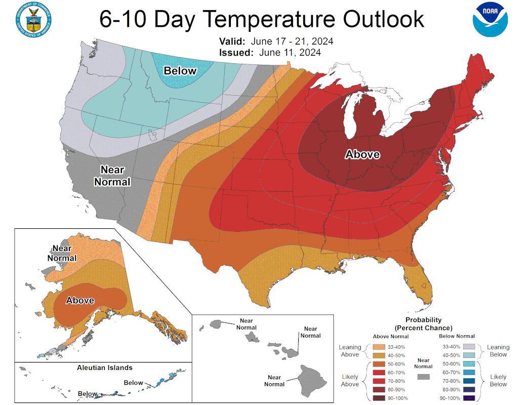
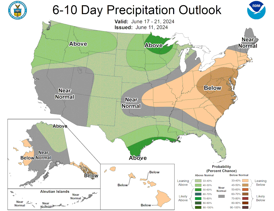
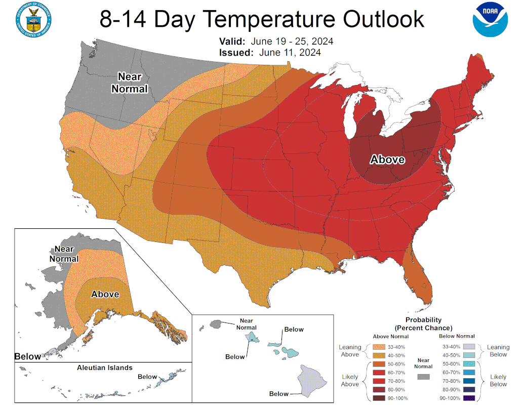
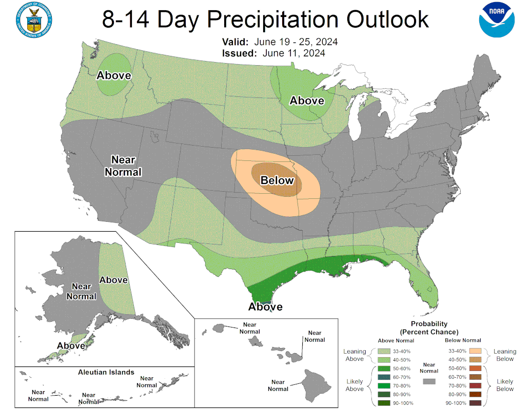
Oh baby!! That CPC forecast today is looking marvelous! Best I’ve seen it in a long time.
The 12z GEFS is a lot wetter than previous runs. Looks like support is increasing for a big rain event next week.

Post 'em if you can.
-
Stratton20
- Posts: 5439
- Joined: Tue Feb 09, 2021 11:35 pm
- Location: College Station, Texas
- Contact:
Zooming in on se texas and the houston metro area, here are the 12z GFS and CMC run, while both models differ on the location, this has to be watched very closely as models are showing the potential for a significant rainfall event next tuesday- thursday, alot to watch, Euro has 3-5 inches across se texas
- Attachments
-
- IMG_3143.png (366.39 KiB) Viewed 2377 times
-
- IMG_3142.png (376.6 KiB) Viewed 2377 times
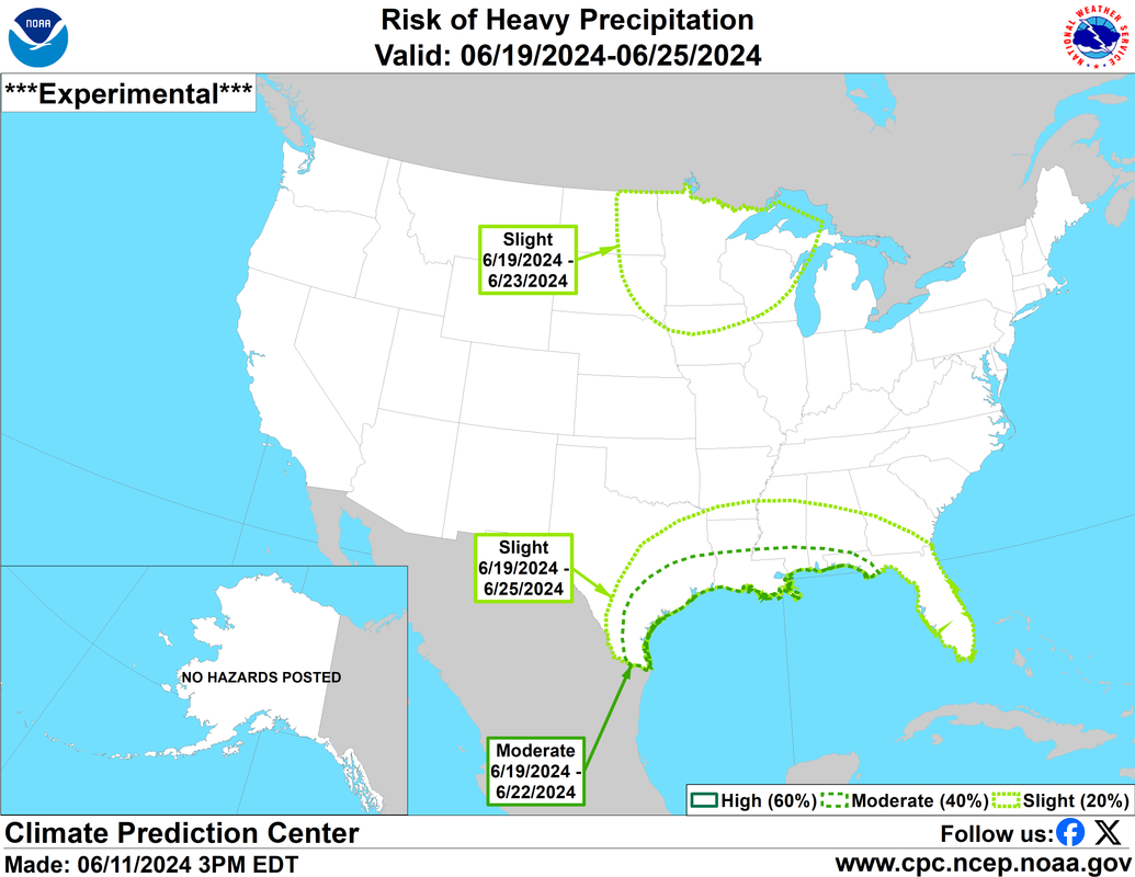
^That's a long way out for a moderate heavy rain CPC prediction. Confidence of getting gyred must be pretty high.
In the meantime, we have a semi-broken line of showers meandering SE.
C'mon keep our sprinklers off tonight (otherwise I'll have no choice but to run them)!
In the meantime, we have a semi-broken line of showers meandering SE.
C'mon keep our sprinklers off tonight (otherwise I'll have no choice but to run them)!