
April 2024
Clouds just cleared in Brazoria County. Full sun at the moment.

A localized/regional severe weather outbreak is possible tomorrow night.Stay weather aware.
- spcdy2cat.us_sc.png (329.92 KiB) Viewed 592 times
- spcdc2tor.us_sc.png (299.05 KiB) Viewed 592 times
- spcdd2hail.us_sc.png (337.55 KiB) Viewed 592 times
- spcd2wind.us_sc.png (298.07 KiB) Viewed 592 times
Last edited by don on Mon Apr 08, 2024 1:51 pm, edited 1 time in total.
-
Stratton20
- Posts: 4251
- Joined: Tue Feb 09, 2021 11:35 pm
- Location: College Station, Texas
- Contact:
Those maps look nasty, fingers crossed for a huge bust!
Couple shots I got with my phone and the cheap NASA filter glasses.


Nice shots!! I couldn’t see jack 
Well that was a bunch of hoopla for nothing. Hopefully we can go back to talking about the weather now.
Could be bad north of I-10.
-
Stratton20
- Posts: 4251
- Joined: Tue Feb 09, 2021 11:35 pm
- Location: College Station, Texas
- Contact:
Cpv17 yeah i dont expect anything here today, that line looks like its pushing north, kinda weird to see that storm motion
Two severe thunderstorm warnings have been issued.Those are some mean looking cells.
A Tornado watch has also been issued for the northern counties.
A Tornado watch has also been issued for the northern counties.
- Screenshot 2024-04-08 at 14-36-57 NWS Radar.png (128.15 KiB) Viewed 547 times
- ww0090_overview_wou.gif (55.83 KiB) Viewed 542 times
BULLETIN - IMMEDIATE BROADCAST REQUESTED
Severe Thunderstorm Warning
National Weather Service Houston/Galveston TX
214 PM CDT Mon Apr 8 2024
The National Weather Service in League City has issued a
* Severe Thunderstorm Warning for...
Northeastern Montgomery County in southeastern Texas...
Southwestern San Jacinto County in southeastern Texas...
Southwestern Polk County in southeastern Texas...
Southeastern Walker County in southeastern Texas...
* Until 245 PM CDT.
* At 214 PM CDT, a severe thunderstorm was located 9 miles east of
New Waverly, or 10 miles northeast of Willis, moving northeast at
30 mph.
HAZARD...Quarter size hail.
SOURCE...Radar indicated.
IMPACT...Damage to vehicles is expected.
* Locations impacted include...
Coldspring, Evergreen, and Oakhurst.
PRECAUTIONARY/PREPAREDNESS ACTIONS...
For your protection move to an interior room on the lowest floor of a
building.
A Tornado Watch remains in effect until 800 PM CDT for southeastern
Texas.
HAIL THREAT...RADAR INDICATED
MAX HAIL SIZE...1.00 IN
WIND THREAT...RADAR INDICATED
MAX WIND GUST...<50 MPH
don wrote: ↑Mon Apr 08, 2024 2:37 pm Two severe thunderstorm warnings have been issued.Those are some mean looking cells.
A Tornado watch has also been issued for the northern counties.
Screenshot 2024-04-08 at 14-36-57 NWS Radar.png
ww0090_overview_wou.gif
BULLETIN - IMMEDIATE BROADCAST REQUESTED
Severe Thunderstorm Warning
National Weather Service Houston/Galveston TX
214 PM CDT Mon Apr 8 2024
The National Weather Service in League City has issued a
* Severe Thunderstorm Warning for...
Northeastern Montgomery County in southeastern Texas...
Southwestern San Jacinto County in southeastern Texas...
Southwestern Polk County in southeastern Texas...
Southeastern Walker County in southeastern Texas...
* Until 245 PM CDT.
* At 214 PM CDT, a severe thunderstorm was located 9 miles east of
New Waverly, or 10 miles northeast of Willis, moving northeast at
30 mph.
HAZARD...Quarter size hail.
SOURCE...Radar indicated.
IMPACT...Damage to vehicles is expected.
* Locations impacted include...
Coldspring, Evergreen, and Oakhurst.
PRECAUTIONARY/PREPAREDNESS ACTIONS...
For your protection move to an interior room on the lowest floor of a
building.
A Tornado Watch remains in effect until 800 PM CDT for southeastern
Texas.
HAIL THREAT...RADAR INDICATED
MAX HAIL SIZE...1.00 IN
WIND THREAT...RADAR INDICATED
MAX WIND GUST...<50 MPH
I wonder if this is gonna shift any further south as spring progresses.
That cell currently (2:59pm CDT 4/8/2024) over Lake Livingston/Onalaska is the nastiest looking cell I've ever seen up close on Weather Underground's Wundermap
Holy Hell, I hope they're ok over there.
Holy Hell, I hope they're ok over there.
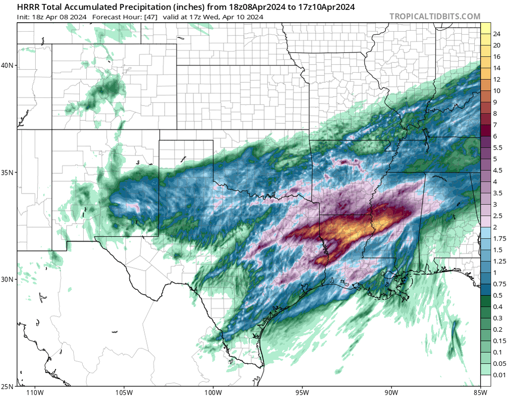
18Z HRRR
- Screenshot 2024-04-08 at 15-08-12 Models HRRR - Pivotal Weather.png (577.6 KiB) Viewed 499 times
- Screenshot 2024-04-08 at 15-08-19 Models HRRR - Pivotal Weather.png (590.26 KiB) Viewed 499 times
- Screenshot 2024-04-08 at 15-08-57 Models HRRR - Pivotal Weather.png (621.45 KiB) Viewed 499 times

We did miraculously get a break in the clouds in CLL before the line of storms that allowed us to see 90% totality. Just a thin crescent.
Well done! I should have taken photos through a pair of classes rather than the iPhone filter we got online. It was impossible to filter then expand the image. Doh.
I did use tree shadows to get something. Anyway the 90% eclipse looked visually great through the protective glasses. In retrospect, we should have driven to Lampasas. North of San Antonio was a bust.
- Attachments
-
- IMG_6559.jpeg (3.22 MiB) Viewed 471 times
Pretty meh rain totals though. Gives me about half an inch to one inch. Hopefully I can get that. We could kinda use it. Looks much better north of me.
Very blustery this morning.
The SPC already has a day 7 risk for the Texas panhandle. So it looks like an active severe weather season could be setting up.
Still looking nasty for us this evening?
Dixie Alley primed to get smacked hard tomorrow.
Dixie Alley primed to get smacked hard tomorrow.
-
tireman4

- Global Moderator

- Posts: 4496
- Joined: Wed Feb 03, 2010 9:24 pm
- Location: Humble, Texas
- Contact:
000
FXUS64 KHGX 091144
AFDHGX
Area Forecast Discussion
National Weather Service Houston/Galveston TX
644 AM CDT Tue Apr 9 2024
...New AVIATION...
.SHORT TERM...
(Today through Wednesday Night)
Issued at 347 AM CDT Tue Apr 9 2024
Showers are moving into the southern CWA from South Texas this
morning. So far observing drizzle and light rain in those areas.
Expect showers to continue with elevated convection possible for
northern counties closer to sunrise.
A stronger shortwave is set to move across SE Texas during the day
today and will interact with a strong LLJ (40-70kts) as well as a
weak surface trough. Forecast soundings reveal CAPE values in excess
of 2000 J/kg for much of the area in addition to strong bulk shear
(around 60 kts), a decent amount of SRH, and steep mid-level lapse
rates (8-9°C/km). With all the parameters in place, ample moisture,
and the aforementioned trough/LLJ/shortwave, this should initiate
strong thunderstorms capable of producing damaging wind and large
hail. Daytime heating, of course, will help to further destabilize
the atmosphere for these stronger thunderstorms. Expect thunderstorm
chances to continue through much of the day, mainly north of the I-
10 corridor.
The greatest threat for severe weather and excessive rainfall will
be this evening into Wednesday morning. The upper-level low that has
gradually been making its way into Texas from the Four Corners
region will finally move through Texas and the Great Plains today,
and will eject a surface boundary eastward tonight. At this time
forecast sounding profiles continue to suggest a highly unstable
environment sticking around during this time frame, with strong
shear, CAPE values exceeding 2000 J/kg, increasing 0-3km SRH, and
steep mid-level lapse rates. This should support the development of
strong updrafts within an eastward moving MCS. Some of these
thunderstorms could become supercellular. The main hazards
associated with the convection tonight/overnight will be the
potential for strong damaging winds, large to very large hail, a few
tornadoes (some of which could err on the stronger side), and
localized heavy rainfall. Should storms become slow moving or train
across the same areas, it could easily produce a quick 2-3 inches of
rain across the northern counties and result in instances of flash
flooding.
While the entirety of SE Texas is in at least a SLIGHT risk (level 2
of 5) for severe weather, areas along and north of the I-10 corridor
has been placed in an ENHANCED risk (level 3 of 5). The enhanced
risk area will also be the area with the greatest chance of
experiencing severe hail (30-44% chance). The rest of the CWA has a
15-29% chance of experiencing severe hail. The entire area,
excluding the immediate coast, is in a hatched area indicating at
least a 10% chance for significant severe hail (diameter of 2" or
greater).
In addition to the hail threat, there is the threat for tornadoes,
with the highest probabilities (10-14%) lying in the majority of the
aforementioned enhanced risk area. Furthermore, SPC has locations
generally east of I-45 and north of I-10 in a hatched tornado risk,
indicating the potential for a few stronger tornadoes.
WPC has placed most of the area in a SLIGHT risk for excessive
rainfall (level 2 of 4) with a sliver of our far NE CWA in a
MODERATE risk (level 3 of 4). Again, this will depend on the forward
motion of storms as well as if storms train over the same locations.
The severe weather threat will continue into Wednesday as SPC has an
area east of a line from College Station to Palacios in a Marginal
risk, and a sliver of our eastern counties in a Slight Risk.
Please have multiple ways to receive alerts with the threat for
severe weather today. This is a good time to go over safety plans
with your family, coworkers, etc. and please, please, please, have a
plan for your pets. With the severe weather threat extending into
the overnight hours, it is especially important to make sure that
all devices are charged and to double check that you are able to
receive audible notifications should a warning be issued for your
location.
Adams
&&
.LONG TERM...
(Thursday through Monday)
Issued at 347 AM CDT Tue Apr 9 2024
High pressure will be building into the state on Thursday. Breezy conditions
can be expected in the morning, and look for gradually decreasing winds
in the afternoon as the pressure gradient begins to weaken. Sunny skies
can be expected. Temperatures will be back to seasonal readings Thursday
through Saturday morning as surface high moves slowly eastward across
the state (daily lows mainly in the 50s, highs in the 70s to around
80 Thursday and upper 70s to lower 80s on Friday). With the high off
to the east over the weekend, look for a warming trend to commence as
southeast winds return to the area and gradually strengthen. Look for
highs mostly in the low to mid 80s while lows warm up from the low to
mid 60s on Sunday morning to the mid to upper 60s on Monday morning.
With the warming trend comes increasing humidities along with increasing
cloud cover. Monday afternoon could be our first chance of having some
rain return to the area, but Tuesday looks like the day when better
rain chances should cover more of our area as the next storm system
and associated cold front head in our direction from the west. 42
&&
.AVIATION...
(12Z TAF Issuance)
Issued at 629 AM CDT Tue Apr 9 2024
A messy aviation forecast continues today. Showers and
thunderstorms are ongoing across portions of SE Texas, and will
continue through the morning. Following a break in precipitation
this afternoon, another organized round of showers and
thunderstorms will move in from the west late tonight through
Wednesday morning. Some of these storms could become strong to
severe with damaging winds, large to very large hail, and
tornadoes possible. CIGS are expected to remain a mixture of
MVFR/IFR through the period.
&&
.MARINE...
Issued at 347 AM CDT Tue Apr 9 2024
A long fetch of moderate onshore winds and elevated seas will set up
across the area into early Wednesday. As this occurs, winds and seas
will remain elevated and will support small craft advisories. Periods
of showers and thunderstorms can be expected through Wednesday morning
as the next storm system approaches from the west. A cold front will
move into the waters during the day Wednesday with moderate to strong
offshore winds developing in its wake. Expect a return to advisory
conditions Wednesday night. Winds will gradually weaken and seas will
slowly come down Thursday afternoon through Thursday night. Southeast
winds will return to the area at the end of the week and gradually
strengthen over the weekend. Elevated water levels in the bays ahead
of Wednesday`s cold front will transition to below normal levels late
Wednesday night and Thursday behind the front. 42
&&
.CLIMATE...
Here are the daily rainfall records (inches/year) for today (Tuesday 4/9)
and tomorrow (Wednesday 4/10).
College Station Houston Houston Hobby Galveston Palacios
Tue: 2.05/1924 2.68/1913 3.08/1959 2.77/1968 4.37/1970
Wed: 1.80/1978 2.57/2004 0.90/1975 1.88/1926 1.92/2015
42
&&
.PRELIMINARY POINT TEMPS/POPS...
College Station (CLL) 80 62 74 52 / 70 70 20 0
Houston (IAH) 83 68 78 55 / 40 80 40 0
Galveston (GLS) 76 67 76 59 / 20 70 40 0
&&
.HGX WATCHES/WARNINGS/ADVISORIES...
TX...High Rip Current Risk through this evening for TXZ436>439.
GM...Small Craft Advisory until 7 PM CDT this evening for GMZ330-335.
Small Craft Should Exercise Caution from this evening through
late tonight for GMZ330-335.
Small Craft Advisory until 1 AM CDT Wednesday for GMZ350-355-370-
375.
&&
$$
SHORT TERM...Adams
LONG TERM....42
AVIATION...Adams
MARINE...42