MontgomeryCoWx wrote: ↑Sat Mar 16, 2024 4:01 pm
It feels like swamp *** in Weimar at the moment. Atmosphere feels unstable. Late afternoon into overnight could get frisky.
You're just west enough to seem some isolated cells. The temps and moisture on on the rise. We're screwed by a large patch of dry air working up the coast.
There's a UL trough in Mexico. It's that or probably bust for us.
Area Forecast Discussion
National Weather Service Houston/Galveston TX
317 PM CDT Sat Mar 16 2024
...New SHORT TERM, LONG TERM, MARINE...
.SHORT TERM...
(This evening through Sunday Night)
Issued at 317 PM CDT Sat Mar 16 2024
Though our CWA has not been void of thunderstorms today, the
presence of a thick LL/ML cloud deck has resulted in sufficient
stabilization to mitigate the thunderstorm coverage and intensity so
far. A weak boundary has been situated across our southern counties
today, separating the warmer / more humid coastal air mass (some
spots near 80 with dew points in the low 70s) with the less warm /
juicy air mass inland (generally mid 60s to low 70s temps with 60s
dew points). A weakening MCS is moving eastward along this frontal
boundary. Though it was producing some heavy thunderstorms earlier
today across our southwestern counties, it has since been downgraded
to a blob of showers as it enters the Houston metro area.
The atmosphere becomes more synoptically interesting tonight into
tomorrow morning. Southwesterly UL flow will become increasingly
diffulent overnight while a 50-60 kt 500MB southwesterly jet ejects
from northern Mexico into southern/coastal Texas. Peak synoptic
ML/UL ascent is expected to occur roughtly between the 3AM and 10AM
time frame. Meanwhile, PWATs are likely to surge overnight as well.
Ensemble means depict a high chance of 1.6" to 1.8" values while
deterministic guidance suggest the potential for our southern/coastal
counties to exceed 2.0 inches. LL instability is expected to be
lacking. HREF means and forecast soundings indicating very low LL
CAPE. However, MU CAPE and ML lapse rates should be more than
sufficient for deep convection. So synoptically speaking,
conditions are expected to be favorable for widespread showers and
thunderstorms. Confidence is lower regarding how small scale
features such as LL boundaries and `small` vort maxes embedded in
the flow aloft will enhance, or not enhance, convection. [lost of these approaching Weimar]
Regardless, a few strong to severe thunderstorms will be possible
late tonight into tomorrow morning. The primary concerns will once
again be large hail and damaging wind gusts. Though strong
thunderstorms are possible across the entire CWA, the overall set
up does seem to favor the southern half of the CWA a little more
than the northern half. [We'll see!] Given the high PWATs and recent heavy
thunderstorms, localized flash flooding will be possible as well.
By Sunday, a ~1030-1032MB SFC high will drift southward across the
northern and central plains, pushing a drier / cooler air mass
towards SE Texas. However, this air mass is not expected to reach
our neck of the woods until Sunday night. Therefore, we opted to
keep clouds, lingering showers, and 70s temps / 60s dew points in
the forecast through Sunday afternoon. Overnight lows are expected
to drop into the 50s with lowering humidity. Northernmost counties
could drop into the 40s.
Self
&&
.LONG TERM...
(Monday through next Friday)
Issued at 317 PM CDT Sat Mar 16 2024
Expect clouds to begin scattering out from ne-sw during the day
Monday as some drier filters in behind the front. We`ll see clouds
return by late Tuesday into Wednesday as some mid-upper impulses
move into the region from Mexico (in combination with llvl winds
gradually veering to the east & southeast). Doubt there will be
enough column moisture for these disturbance(s) to produce rain
that survives the fall to the surface prior to early afternoon
Wed...but also wouldn`t be too surprised to see some radar returns
from virga.
Heading into late Wed and Thurs, the cutoff low/trof that has been
hanging out across the Desert Southwest will be opening up and
making its way toward Texas and the Southern Plains. The airmass
will probably be modified enough to re-insert POPs back into the
forecast as this occurs by Wed evening. Best shower/thunderstorm
chances will probably occur on Thursday with the combination of
increased large scale lift, some coastal troffiness and the
dryline to our west all being players. Deterministic model
solutions are a bit more bullish than the blends in regards to
overall precip coverage than what the blends and current fcst
reflects...so rain chances may need to be bumped up going forward.
The upper trof passes to our east Thurs night & early Friday. A
drier northwest flow aloft will take shape into next weekend.
Overall, temperatures should be around seasonable norms for the
vast majority of the week. 47
Pas_Bon wrote: ↑Sat Mar 16, 2024 3:32 pm
I’m not sure why models and Mets are having so much trouble pegging down timing and rain/no rain lately. It seems that either the whole event is a bust or the timing is way off. I know it’s not an exact science, but it just seems more off than normal the past couple years. It’s probably just me in my feels hoping for today’s gully washer. I realize it may come tomorrow, but I don’t trust it much anymore.
Its always been that way, especially when we're dealing with the subtropical jet.Theirs not a lot of data coming from Mexico so the models have always had a hard time with pinpointing timing and strength of disturbances coming out of Mexico.The mesoscale models are your best friend.And when you see most of them in agreement just like yesterday, you can have good confidence in the rain being here tonight/tomorrow.I only really post here when i feel there's good data to support a decent event.
BTW looking at the severe weather reports locally I feel the SPC should have had us under an enhanced risk yesterday,instead of it being placed over south Texas where hardly any severe weather reports transpired.
Screenshot 2024-03-16 at 15-26-52 Storm Prediction Center Yesterday's Storm Reports(1).pngScreenshot 2024-03-16 at 15-28-54 Storm Prediction Center Mar 15 2024 2000 UTC Day 1 Convective Outlook.png
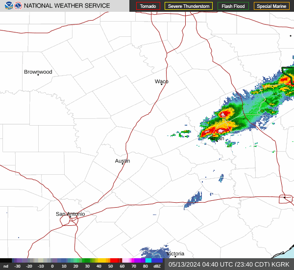
djmike wrote: ↑Sat Mar 16, 2024 6:20 pm
Whens it supposed to start firing off? Its now 6pm and still nothing on radar (except the Dallas blob).
Not till late tonight/overnight.Storms will first start firing off in South and South Central Texas around midnight.And form into a complex or thunderstorm cluster(s). As that disturbance exits the area tomorrow morning,another system will be moving into the area tomorrow afternoon.We'll have to see how much the atmosphere can recover from the first round of storms overnight.Determining the potency of the storms with the 2nd system tomorrow afternoon.
Pas_Bon wrote: ↑Sat Mar 16, 2024 3:32 pm
I’m not sure why models and Mets are having so much trouble pegging down timing and rain/no rain lately. It seems that either the whole event is a bust or the timing is way off. I know it’s not an exact science, but it just seems more off than normal the past couple years. It’s probably just me in my feels hoping for today’s gully washer. I realize it may come tomorrow, but I don’t trust it much anymore.
Its always been that way, especially when we're dealing with the subtropical jet.Theirs not a lot of data coming from Mexico so the models have always had a hard time with pinpointing timing and strength of disturbances coming out of Mexico.The mesoscale models are your best friend.And when you see most of them in agreement just like yesterday, you can have good confidence in the rain being here tonight/tomorrow.I only really post here when i feel there's good data to support a decent event.
BTW looking at the severe weather reports locally I feel the SPC should have had us under an enhanced risk yesterday,instead of it being placed over south Texas where hardly any severe weather reports transpired.
Screenshot 2024-03-16 at 15-26-52 Storm Prediction Center Yesterday's Storm Reports(1).pngScreenshot 2024-03-16 at 15-28-54 Storm Prediction Center Mar 15 2024 2000 UTC Day 1 Convective Outlook.png
Thanks so much for the info/synopsis!
The mesos have a gap where we are.
But they've been wrong on location of the rain, which was progged to be highest in the Brazos Valley and Piney Woods east of here (wrong and wrong)