brazoriatx wrote: ↑Thu Jan 11, 2024 4:15 pm
Nws took away my 20% freezing rain and updated with 30% of showers and a high of 41 on monday. Wtf lol
Let me say this. This forecast is ever changing. I think each shift ( morning and afternoon and night) will have different takes on this. I agree with MoCo, this is a now cast and trust me, those numbers you see will change. I would wait until Saturday on this one.
I'm going to go with the WOS model for this event. Just too many differences coming in with the others... Oh, the WOS stands for Walk OutSide and see what it's doing, and go with it.
It has been stated on here and over at S2K that this will be a tricky forecast. This weekend will give forecasters fits on just what might happen. Saturday will be a day we see how the air mass is reacting as it traverses the CONUS. Then I think they can zero in on a reliable forecast.
MontgomeryCoWx wrote: ↑Thu Jan 11, 2024 2:39 pmMy guess is, at some point tomorrow all models will show a frontal passage before 19z Sunday.
Yeah, the ICON has now switched to that scenario on the latest 18z. But there's still more of a "warmup" with afternoon highs in the 40s/50s compared to the 30s shown in the NAM.
don wrote: ↑Thu Jan 11, 2024 11:54 amMajor differences between the NAM and GFS with the frontal passage. The NAM has the freeze line almost to the I-59 corridor by Sunday evening.While at the same time the GFS has temps in the 50's and 60's.This is because the GFS stalls the front, we've seen the GFS do this time and time again with shallow arctic air. The NAM usually will be far more accurate with these setups.
(If the NAM is correct by the time precip starts overnight Sunday-Monday most of us will already be around or below freezing)
The cold air usually outperforms GFS, especially timing. CLL may not get out of the 20s on Monday.
18z NAM is beginning wintry ice/snow mix early and often. The next day of progs is going to get interesting. NAM is leaning toward a coastal disturbance running up the coast.
Scott747 wrote: ↑Thu Jan 11, 2024 12:33 pm
Natty futures have been on the rise for the last week or so when the models were hinting a potential outbreak. Only put part of the kids inheritance on some contracts.
Miss the old days when there weren't so many hedge funds and banks that didn't employ traders that specifically followed longer term model trends. Way too many weather nerds now. lol.
The 2017/2018 tax bill gave the hedge fund managers get out of jail free cards. They manipulate stock and commodity markets.
DoctorMu wrote: ↑Thu Jan 11, 2024 11:08 am
GFS is close to an agreement.
KHOU has it right IMO.
GFS has sleet/snow from a coastal low on Friday the 19th.
Can you explain? I haven’t heard anyone in Media, social media mention any sort of system around this timeline and the cold air was supposed to retreat by then. They have us in the 60s Thursday
We'll struggle to reach 50°F on Thursday and 40°F on Friday (our local KBTX). I'm siding with overperformance and a high of 44°F Thursday and a chance of wintry precip Friday am. IMO, CLL will be below freezing Sunday - Wednesday afternoon. A modest and rapid warm-up followed by a front and potential mischief late next week. Lows will be in the teens Mon, Tue, Wed mornings. At least 8 consecutive days with subfreezing lows.
Buckle up.
The Houston TV stations have been migrating away from serious mets over the past 5-10 years.
brazoriatx wrote: ↑Thu Jan 11, 2024 4:03 pm
So r we counting on the sbj to give us precip? I thought we were watching a disturbance south of Alaska or something a cpl days ago?
It’s 2 separate things. Mexico can always bring us surprises.
You never know what disturbances/waves from MX or a coastal low with effects amplified by the SJT.
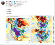
NEW: The latest round of data coming into the ABC13 Weather Center suggests three things you need to know about this approaching arctic cold front.
1. TIMING: We can now say with greater confidence the leading edge of arctic air will reach most of us before sunrise on Sunday, and the freeze line may already be into Southeast Texas at that time.
2. FREEZING RAIN POTENTIAL: This increases the chances for light freezing rain starting Sunday night through MLK Day. We still have low confidence on the position of the freeze line Monday, but it's going to be a close call for Houston during the daylight hours. Accumulations will range from a few hundredths of an inch to a few tenths based on how far north one is from the freeze line. South of the freeze line, it's all a cold rain. We'll have a better feel on the freeze line's location and how much could accumulation starting tomorrow (Friday).
The map I have shared with you showcases one of our better computer models in arctic events, and that model is just now getting into range of seeing the arctic air. It shows the freeze line (magenta line) approaching Houston *Sunday night* with light freezing rain already beginning in Southeast Texas north of that line.
3. DURATION OF FREEZING TEMPS: There is a growing likelihood we'll have a long duration freeze including two "hard freeze" dips into the upper 10s and low 20s. For most of us, this freeze will start sometime on Monday and end sometime on Wednesday. That means we should prepare for at least a solid 36 hours of time at our below freezing if we don't climb above 32° on Tuesday.