

Forecast low: 32
Actual low: 30.9
iPhone weather app shows 15 Tuesday Morning but back up to 63 next Thursday afternoon.
January 2024


-
MontgomeryCoWx

- Posts: 2356
- Joined: Wed Dec 14, 2011 4:31 pm
- Location: Weimar, TX
- Contact:
Does anyone really know how the iPhone app and others digests temps?
I know TWC and WU have a heavy dose of climo in them past 5 days and that’s why they don’t correct until it gets close.
Team #NeverSummer
This is all I can find without digging. I have to say the Apple Weather forecasts are getting pretty good, even in the long range. They don’t appear to hug any particular model. Many of the original weather apps were nothing more than the GFS repackaged. They’ve definitely come a long way.MontgomeryCoWx wrote: ↑Wed Jan 10, 2024 10:07 amDoes anyone really know how the iPhone app and others digests temps?
I know TWC and WU have a heavy dose of climo in them past 5 days and that’s why they don’t correct until it gets close.
https://support.apple.com/en-us/105038

-
brazoriatx
- Posts: 329
- Joined: Tue Nov 08, 2011 12:09 pm
- Contact:
-
Stratton20
- Posts: 4250
- Joined: Tue Feb 09, 2021 11:35 pm
- Location: College Station, Texas
- Contact:
the GFS is starting to trend towards the euro solution in terms of wintry precipitation, the 12z GFS has a less sheared out shortwave so its able to produce some light precipitation over se texas before moving out, the 06z GEFS is also becoming more bullish fwiw

Models maybe trending back towards wintry precip...? The GFS shows light freezing rain and even the Canadian model that was showing nothing.Is now showing frozen precip here.
Candian model:

Candian model:
We'll see how things go regarding whether or not the ice and/or snow stick. Regardless of that, the 12zGFS actually features quite milder temps compared to the previous two runs.
Even the "notoriously good at handling shallow airmasses" ICON came in quite milder on this latest 12z compared to what it was showing throughout the previous 00z and yesterday's 12z runs.
Even the "notoriously good at handling shallow airmasses" ICON came in quite milder on this latest 12z compared to what it was showing throughout the previous 00z and yesterday's 12z runs.
Tag me as “not surprised”user:null wrote: ↑Wed Jan 10, 2024 11:04 am We'll see how things go regarding whether or not the ice and/or snow stick. Regardless of that, the 12zGFS actually features quite milder temps compared to the previous two runs.
Even the "notoriously good at handling shallow airmasses" ICON came in quite milder on this latest 12z compared to what it was showing throughout the previous 00z and yesterday's 12z runs.

By the way, the image below shows what the GFS was spitting out about a week prior to the Feb 21' freeze:
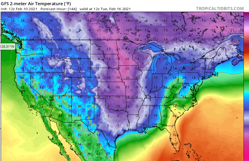
Literal single-digts, even negatives (!!!) well down to the shorelines of SE Texas/SW Louisiana. Hence, we can clearly see that the global was very much "aware" of the "shallow cold severity" even that far out, and was not "staying too warm" — if anything, the actual low temps (while still very intense) verified MUCH milder than what that particular run showed (low 20s along the shore, nothing below teens in metro Houston, Victoria, Corpus, etc, the single digits were off towards College Station, Austin, etc, and the negatives were up in Dallas, Shreveport, etc).
So it has been seen what even globals spit out with a legit cold threat like Feb 21'. Contrast that with the same GFS model on the latest 12z showing above freezing highs next week (even into low 40s in parts), with lows no lower than 20s. Hence, even with "shallow cold airmasses", it isn't always "globals too warm".
Last edited by user:null on Wed Jan 10, 2024 12:07 pm, edited 2 times in total.
Excellent post
-
Stratton20
- Posts: 4250
- Joined: Tue Feb 09, 2021 11:35 pm
- Location: College Station, Texas
- Contact:
Even still the “warmer” ICON run shows sub freezing highs for almost 72 hours and thats not factoring in any potential precip on the ground, the ICON and CMC still have a better handle temperature wise, I still think the GFS is too warm, especially if their is any ice/ sleet on the ground, I dont see houston getting above freezing until wednesday morning
Last edited by Stratton20 on Wed Jan 10, 2024 11:59 am, edited 1 time in total.
-
MontgomeryCoWx
- Posts: 2356
- Joined: Wed Dec 14, 2011 4:31 pm
- Location: Weimar, TX
- Contact:
ICON isn’t any milder for me. Below freezing Sunday night until 21z Wednesday with a high of 33. A lot of that time is in the teens.
May not show the single digits from a couple days ago.
, but that was a long shot without a heavy storm.
GFS handled the upper air progression way off there. Of course the GFS will bounce around dramatically until Saturday/Sunday. It did in 21 and 22. GFS went from coldest to warmest a handful of times during the 21 bout.
Looking upstream, into Canada, the ICON and Canadian are handling those temps better than GFS and even Euro.
Team #NeverSummer
-
brazoriatx
- Posts: 329
- Joined: Tue Nov 08, 2011 12:09 pm
- Contact:
I see 13 has changed their tune now showing a 40% of precipitation with a low in the 20's on monday
-
tireman4

- Global Moderator

- Posts: 4491
- Joined: Wed Feb 03, 2010 9:24 pm
- Location: Humble, Texas
- Contact:
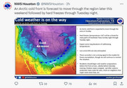
ERCOT has issued a Weather Watch from January 15–17 due to forecasted extreme cold weather across the ERCOT region, higher electrical demand, and the potential for lower reserves. Grid conditions are expected to be normal and can be monitored on https://t.co/qI0IdnNJEI. Read more… pic.twitter.com/3AWusF2DUN
-- ERCOT (@ERCOT_ISO) January 10, 2024
-- ERCOT (@ERCOT_ISO) January 10, 2024
Looks like a quick shot of arctic air to me. And I'm fine with that personally. I think we could have a freezing drizzle event on Monday though. But I would like to see more model runs before completely buying into it yet.(Maybe more than freezing drizzle depending on how fast moisture dries out behind the front.)
Last edited by don on Wed Jan 10, 2024 12:27 pm, edited 1 time in total.
-
txsnowmaker
- Posts: 632
- Joined: Wed Feb 03, 2010 4:07 pm
- Location: SW Houston (Galleria area)
- Contact:
AccuWeather still sticking firm to snow in Houston Metro on Monday (morning).
https://www.accuweather.com/en/us/houst ... ast/351197
https://www.accuweather.com/en/us/houst ... ast/351197
-
Stratton20
- Posts: 4250
- Joined: Tue Feb 09, 2021 11:35 pm
- Location: College Station, Texas
- Contact:
While the brunt of this arctic blast will be Sunday- wednesday ,Ensembles agree that we stay cold through at least the 24/25th ish or so, i dont see much of a warm up, good, keep it cold!

Last edited by Stratton20 on Wed Jan 10, 2024 12:27 pm, edited 1 time in total.
-
- Information
-
Who is online
Users browsing this forum: Bing [Bot], Cromagnum, don, Stratton20, tireman4 and 70 guests