

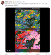
Tornado Warning
National Weather Service Houston/Galveston TX
207 PM CST Mon Jan 8 2024
The National Weather Service in League City has issued a
* Tornado Warning for... Northeastern Montgomery County in southeastern Texas... Southwestern San Jacinto County in southeastern Texas... Southwestern Polk County in southeastern Texas...
* Until 230 PM CST.
* At 206 PM CST, a severe thunderstorm capable of producing a tornado was located 9 miles southwest of Coldspring, or 12 miles northwest of Cleveland, moving northeast at 50 mph.
HAZARD...Tornado.
SOURCE...Radar indicated rotation.
IMPACT...Flying debris will be dangerous to those caught without shelter. Mobile homes will be damaged or destroyed. Damage to roofs, windows, and vehicles will occur. Tree damage is likely.
* This dangerous storm will be near... Coldspring around 210 PM CST. Shepherd, Lake Livingston State Park, and West Livingston around 215 PM CST. Livingston and Goodrich around 220 PM CST.
Other locations impacted by this tornadic thunderstorm include Evergreen.
PRECAUTIONARY/PREPAREDNESS ACTIONS...
TAKE COVER NOW! Move to a basement or an interior room on the lowest floor of a sturdy building. Avoid windows. If you are outdoors, in a mobile home, or in a vehicle, move to the closest substantial shelter and protect yourself from flying debris.
&&
TIME...MOT...LOC 2006Z 223DEG 49KT 3047 9522
TORNADO...RADAR INDICATED
MAX HAIL SIZE...<.75 IN
$$
Cady
January 2024
How cold we talking ? Anyone have an idea yet.
-
Stratton20
- Posts: 4248
- Joined: Tue Feb 09, 2021 11:35 pm
- Location: College Station, Texas
- Contact:
All of SE texas is now under a moderate risk of hazardous temperatures on the newly updated CPC map
-
TexasBreeze
- Posts: 942
- Joined: Sun Sep 26, 2010 4:46 pm
- Location: NW Houston, TX
- Contact:
Sure is a windy spring-like day today!
They are showing mid teens to mid 20's depending on location.
They are showing mid teens to mid 20's depending on location.
Last edited by TexasBreeze on Mon Jan 08, 2024 2:40 pm, edited 1 time in total.


12Z EURO

That 540 thickness line is still pretty far north on the Euro run
-
biggerbyte
- Posts: 1142
- Joined: Thu Feb 04, 2010 12:15 am
- Location: Porter, Texas. (Montgomery County)
- Contact:
Look out Livingston. Tornado Warning
-
Stratton20
- Posts: 4248
- Joined: Tue Feb 09, 2021 11:35 pm
- Location: College Station, Texas
- Contact:
Didnt think you could have frozen precip ahead of the 540 line like what the euro shows
-
MontgomeryCoWx

- Posts: 2356
- Joined: Wed Dec 14, 2011 4:31 pm
- Location: Weimar, TX
- Contact:
At 2:17 a trained spotter reported a tornado on the ground in Coldspring.
The 540 line is only for snow. The snow the EURO shows in SE Texas is probably sleet.Stratton20 wrote: ↑Mon Jan 08, 2024 2:49 pm Didnt think you could have frozen precip ahead of the 540 line like what the euro shows
Last edited by don on Mon Jan 08, 2024 3:01 pm, edited 1 time in total.
Updated warning text indicates spotter-observed tornado history.
Clouds are hauling the mail, but not sure how many more discreet cell potential exists. Not going to take much to get something going.
Agree on the windbag squall line. Gotta watch for embedded spin ups.
I don't like that the sun is trying to come out now. We need to watch the squall line developing to our west closely.
998mb here. 29.48”
-
MontgomeryCoWx
- Posts: 2356
- Joined: Wed Dec 14, 2011 4:31 pm
- Location: Weimar, TX
- Contact:
Squall line on me and that north wind!!!!! Wow
Team #NeverSummer
-
brazoriatx
- Posts: 329
- Joined: Tue Nov 08, 2011 12:09 pm
- Contact:
Those wind gust aint messing around
-
- Information
-
Who is online
Users browsing this forum: Ahrefs [Bot], Amazon [Bot], Semrush [Bot] and 51 guests