


January 2024

New MCD for SE Texas - Watch Issuance Likely:
https://www.spc.noaa.gov/products/md/md0017.html
Mesoscale Discussion 0017
NWS Storm Prediction Center Norman OK
1254 PM CST Mon Jan 08 2024
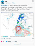
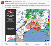
Areas affected...Southeast Texas...Southwest Louisiana
Concerning...Severe potential...Watch likely
Valid 081854Z - 082100Z
Probability of Watch Issuance...80 percent
SUMMARY...Thunderstorms are continuing to slowly intensify, with the issuance of a tornado watch likely in the next 1-3 hours.
DISCUSSION...Scattered thunderstorms continue to intensify across parts of east TX and western LA, mainly along and north of a surface warm front that extends from north of HOU to east of ACT. To the south of the front, surface dewpoints have risen into the mid/upper 60s, with MLCAPE values of 2000-3000 J/kg. VAD profiles near the warm front show very strong low-level vertical shear with 0-3km SRH values of 500 and 900 m2/s2 at HGX and LCH.
Thus far, thunderstorms have been elevated with primarily a large hail threat. Recent CAM solutions suggest that continued daytime heating will begin to aid convective development along the immediate warm front to the west of HOU in the next couple of hours, which would potentially have a greater risk of surface-based supercells and an attendant threat of tornadoes - along with large hail and damaging winds. This area is being closely monitored for convective development and potential tornado watch issuance.
..Hart/Gleason.. 01/08/2024
...Please see www.spc.noaa.gov for graphic product...
https://www.spc.noaa.gov/products/md/md0017.html
Mesoscale Discussion 0017
NWS Storm Prediction Center Norman OK
1254 PM CST Mon Jan 08 2024
Areas affected...Southeast Texas...Southwest Louisiana
Concerning...Severe potential...Watch likely
Valid 081854Z - 082100Z
Probability of Watch Issuance...80 percent
SUMMARY...Thunderstorms are continuing to slowly intensify, with the issuance of a tornado watch likely in the next 1-3 hours.
DISCUSSION...Scattered thunderstorms continue to intensify across parts of east TX and western LA, mainly along and north of a surface warm front that extends from north of HOU to east of ACT. To the south of the front, surface dewpoints have risen into the mid/upper 60s, with MLCAPE values of 2000-3000 J/kg. VAD profiles near the warm front show very strong low-level vertical shear with 0-3km SRH values of 500 and 900 m2/s2 at HGX and LCH.
Thus far, thunderstorms have been elevated with primarily a large hail threat. Recent CAM solutions suggest that continued daytime heating will begin to aid convective development along the immediate warm front to the west of HOU in the next couple of hours, which would potentially have a greater risk of surface-based supercells and an attendant threat of tornadoes - along with large hail and damaging winds. This area is being closely monitored for convective development and potential tornado watch issuance.
..Hart/Gleason.. 01/08/2024
...Please see www.spc.noaa.gov for graphic product...
Storm near Montgomery has hail..

-
MontgomeryCoWx

- Posts: 2356
- Joined: Wed Dec 14, 2011 4:31 pm
- Location: Weimar, TX
- Contact:
The mixing above me right now at the farm is insane
Team #NeverSummer
We now have tornado watch until 9pm all over s.e. tx
Tornado Watch up.

Last edited by Cromagnum on Mon Jan 08, 2024 2:13 pm, edited 1 time in total.
Im right smack in the middle of it, along with DJMike...

-
biggerbyte
- Posts: 1142
- Joined: Thu Feb 04, 2010 12:15 am
- Location: Porter, Texas. (Montgomery County)
- Contact:
Tornado watches being issued. Personally, I'd watch the radar for bow echos as things get cranked up. Strong winds are a definite possibility.
Popcorn everywhere right now, but hail so far is staying in our northern area.
Further west, the cell just east of Seguin is nasty.
Further west, the cell just east of Seguin is nasty.
Last edited by Cromagnum on Mon Jan 08, 2024 2:27 pm, edited 1 time in total.
Anyone else notice this is Tornado Watch #1?
Happy New Year (/sarcasm)
Happy New Year
 (/sarcasm)
999mb and 69 Dewpoint in January…insane
-
MontgomeryCoWx
- Posts: 2356
- Joined: Wed Dec 14, 2011 4:31 pm
- Location: Weimar, TX
- Contact:

EURO onboard with snow next Monday.


Last edited by don on Mon Jan 08, 2024 2:35 pm, edited 1 time in total.
-
biggerbyte
- Posts: 1142
- Joined: Thu Feb 04, 2010 12:15 am
- Location: Porter, Texas. (Montgomery County)
- Contact:
Look out to San Antonio. Nasty