

Area Forecast Discussion National Weather Service Houston/Galveston
TX 331 PM CDT Sat Jul 1 2023
...New SYNOPSIS, SHORT TERM, LONG TERM, MARINE...
.SYNOPSIS...
Issued at 331 PM CDT Sat Jul 1 2023
After a long stretch of unseasonably hot conditions, this week we
should begin to ease our way back to something closer to seasonable
levels of heat. Don`t get too wild, though -temperatures still look
to be near or a little above seasonal averages, and even your
"typical" summer heat in Southeast Texas can be dangerous if treated
flippantly.
Another sign of a return to more seasonable conditions is the return
of our summertime showers and storm pattern. We may see some
isolated to scattered showers and storms as early as tomorrow, but
should increasingly push their way into the daily pattern and become
more numerous towards the middle of the week.
&&
.SHORT TERM...
(This evening through Sunday Night) Issued at 331 PM CDT Sat Jul 1
2023
Tranquil and warm conditions expected tonight with low temperatures
mostly in the upper 70s to low 80s. Some isolated patchy fog is
possible across portions of Southeast TX overnight into early Sunday
morning.
On Sunday, a shortwave will be making it`s way across Southeast TX
and this will help inhibit some of the subsidence we have had in
place for so many days. It may, however, not be strong enough to
allow for much rain to develop. Thus, kept the slight chance (around
15 to 20%) for the southern half of Southeast TX. With the high
pressure weakening, temperatures will decrease a degree or two and
heat indices will also be slightly lower. We will likely see highs
in the mid to upper 90s Sunday afternoon with heat indices of around
103 to 107 degrees F. Some spots could have heat indices reaching
108 degrees F, but it may be isolated enough to not warrant a Heat
Advisory. Regardless, it will still be hot and potentially
dangerous. Thus, make sure to continue to practice heat safety if
you plan to work or spend time outdoors. Remember to stay in shaded
areas, hydrate often, wear sunscreen and protective light and loose
clothing, take breaks from the sun and heat (including pets), and
never leave children or pets unattended in vehicles. And just like
Batiste wrote this morning...If the ground is too hot for the palm
of your hand, then it is too hot for their paws. Stay safe, stay
cool, and stay hydrated.
Another calm and warm night is on tap for Sunday night with lows
once again in the upper 70s to low 80s. Isolated passing showers is
possible along the coastal waters and coasts early Monday.
&&
.LONG TERM...
(Monday through next Friday) Issued at 331 PM CDT Sat Jul 1 2023
Monday morning comes along and...not only is the subtropical ridge
aloft weaker, but it`s even broken down enough that we`ll find
ourselves underneath a relative weakness as an upper trough scrapes
across the northern half of the country. We still find ourselves in
a fairly ridgy pattern all the way down to the surface, but at least
it should be enough to relax the grip of the long, early summer
heatwave we`ve experienced. Monday, and really the rest of the
workweek should bring us high temperatures that are near or slightly
above normal...at least closer to normal than to records, and that`s
a step forward.
We may not be totally out of the woods on temperature-related
threats, though. As we get deeper into the week, both the NAEFS and
Euro ensembles bring their mean specific humidity at 925 mb towards
the extreme end of the percentiles for high moisture. A more
saturated lower level means we`re not going to be able to mix out as
effectively in the afternoon. Because of that, I`m less apt to
override the NBM`s dewpoints from mid-week on, as it may stumble
into more correctly keeping afternoon humidity higher.
So, despite some more seasonable temperatures, peak heat index
values still start to creep back up towards those heat advisory
thresholds later in the week. While I tend to think the processes
here will be self-limiting enough that heat headlines aren`t the
most likely outcome here, I have to admit that a need for them is
plausible and something to keep an eye on.
We`ve also got another consequence of this return to more seasonable
conditions, and that`s the return of rain chances! In general, with
the pattern still generally resembling prevailing ridginess, the
seasonal diurnal PoP chances seem the way to go. So from day to day,
we should focus on the Gulf waters in the late night and early
morning hours, gradually shifting towards the land for the
afternoon. In the afternoon, look for those in the vicinity of the
seabreeze to have the best chance for showers and storms, as that
convergence feature will be most effective at getting updrafts
started.
We`ll ease into things early in the week, with the character likely
more in the isolated to scattered range. As that moisture deepens as
mentioned with low level humidity above, and in ensemble
precipitable water values beginning to exceed 2 inches, expect
thunderstorm development to be more numerous in the middle to late
week.
Heading towards the weekend, the midlevel ridge looks to begin to
rebuild itself over the desert southwest. Though there`s not a clear
enough signal to show up in, say, an SPC outlook - we may want to
keep an eye on how northwest flow aloft sets up on Thursday and
Friday. Of course, as the ridge builds into the weekend, we`ll start
to come more under its influence. So Thursday has my peak PoPs,
though I keep a toned down version of the diurnal pattern continuing
through the end of my forecast.
Similarly, I also follow with the NBM in drifting high temps slowly
back upwards towards the middle to upper 90s.
&&
.AVIATION...
(18Z TAF Issuance) Issued at 1219 PM CDT Sat Jul 1 2023
VFR conditions expected with S-SE winds at around 10 KTS. Winds will
relax to 5 KTS or less tonight and lower cigs may return to some
sites late tonight into early Sun morning. Winds will turn S-SW Sun
morning and cigs (if any) will lift and disperse shortly after
sunrise.
24
&&
.MARINE...
Issued at 331 PM CDT Sat Jul 1 2023
Generally light to moderate winds and seas will be the rule for the
large majority of the forecast period. For the most part, expect
winds of 10-15 knots, and accompanying waves of 2-4 feet.
Winds and seas do look to be modestly higher around the mid-week,
and winds and waves should be near the upper end of that range more
often than not.
After a very long stretch of fair weather, daily chances of showers
and storms will begin to return as early as Sunday, likely peaking
in the middle to late week. These rain chances should generally
follow a daily pattern, with the best chances for rain over the Gulf
waters late at night and early in the morning, shifting more towards
the bays in the mid-day and afternoons.
&&
.PRELIMINARY POINT TEMPS/POPS...
College Station (CLL) 78 96 78 96 / 0 0 10 10 Houston
(IAH) 80 97 79 96 / 0 20 10 30 Galveston (GLS) 83 91
82 88 / 0 20 20 40
&&
July 2023
After this week, ridging on the ensembles still is more elongated and weaker than this past week.
I think it just means closer to normal sensible weather progs. Mid to upper 90s. 20+% chance of rain in CLL. 30+% chance in Houston. We'll be on the north side of the ridging, so easterlies and a modest chance of rain for the next 2 weeks beginning tomorrow.

I think it just means closer to normal sensible weather progs. Mid to upper 90s. 20+% chance of rain in CLL. 30+% chance in Houston. We'll be on the north side of the ridging, so easterlies and a modest chance of rain for the next 2 weeks beginning tomorrow.
-
Stratton20
- Posts: 4248
- Joined: Tue Feb 09, 2021 11:35 pm
- Location: College Station, Texas
- Contact:
Definitely could be alot worse, as long as their is at least a chance for rain every day, im happy with that
The CPC has already placed us back to below normal precipitation in their 8-14 day.Stratton20 wrote: ↑Sat Jul 01, 2023 6:05 pm Definitely could be alot worse, as long as their is at least a chance for rain every day, im happy with that
NWS? Not in the 6-10 day outlook. They were wrong all winter on 8-14 outlooks...Cpv17 wrote: ↑Sat Jul 01, 2023 6:18 pmThe CPC has already placed us back to below normal precipitation in their 8-14 day.Stratton20 wrote: ↑Sat Jul 01, 2023 6:05 pm Definitely could be alot worse, as long as their is at least a chance for rain every day, im happy with that
I'm expecting back to the usual/normal, which is a small chance of rain - aka getting lucky.
The s/w west of us stirred up a couple of dinky showers within 5-10 miles of MBY. The main MCS will probably just generate an outflow once it crosses I-35.
For those worried about rainfall prospects, this afternoon’s GFS 18Z run comes to the rescue and brings SE Texas some relief from the heat in 336 hours…
-
Stratton20
- Posts: 4248
- Joined: Tue Feb 09, 2021 11:35 pm
- Location: College Station, Texas
- Contact:
July is looking like a pretty dry month here, weekly guidance is suggesting drier than normal weather through the month, all we can hope for is a little tropical relief, and even that is unlikely with all the activity focused in the EPAC
Yep. That’s what I was hinting at yesterday. Don’t get me wrong, I love summer. Great time for the beach, to go swimming, backyard bbq’s, family vacations, etc. but damn, some occasional afternoon or evening storms would make it so much more tolerable.Stratton20 wrote: ↑Sun Jul 02, 2023 12:18 pm July is looking like a pretty dry month here, weekly guidance is suggesting drier than normal weather through the month, all we can hope for is a little tropical relief, and even that is unlikely with all the activity focused in the EPAC
I hate summer in Texas, which is why I am absolutely not retiring here. The only reason I'm in Houston is because of all the jobs for a chemist. It's pretty much unejoyable weather for 50-60% of every year.Cpv17 wrote: ↑Sun Jul 02, 2023 12:30 pmYep. That’s what I was hinting at yesterday. Don’t get me wrong, I love summer. Great time for the beach, to go swimming, backyard bbq’s, family vacations, etc. but damn, some occasional afternoon or evening storms would make it so much more tolerable.Stratton20 wrote: ↑Sun Jul 02, 2023 12:18 pm July is looking like a pretty dry month here, weekly guidance is suggesting drier than normal weather through the month, all we can hope for is a little tropical relief, and even that is unlikely with all the activity focused in the EPAC
According to certain climate change predictions, retirement isn't even in the cards for younger folks (like myself)...
I think Texas might have to be the most cursed/ripped off state, assuming these recent weather patterns are trends (and not just fluctuations).
Not even necessarily the heat, but too much summer dryness for the bathwater that is the GOM. Then winter cold snaps ruin the otherwise mild season in many respects (agriculture, gardening, etc).
Not even necessarily the heat, but too much summer dryness for the bathwater that is the GOM. Then winter cold snaps ruin the otherwise mild season in many respects (agriculture, gardening, etc).
SE Texas needs a retractable roof.
This is for the next 5 days:
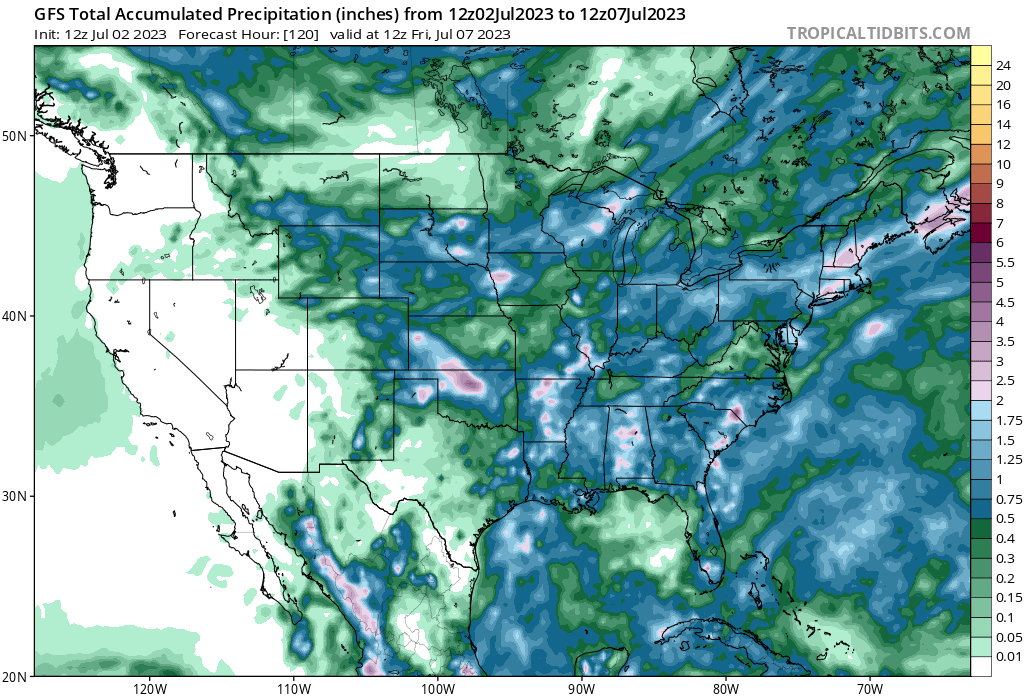
The high that’s been over us has mainly moved off to our east but yet their rain chances still look good. Ridiculous. Like I said a while back, the SE can be under a high and still get good rain.
And this is the next 7 days from the WPC:
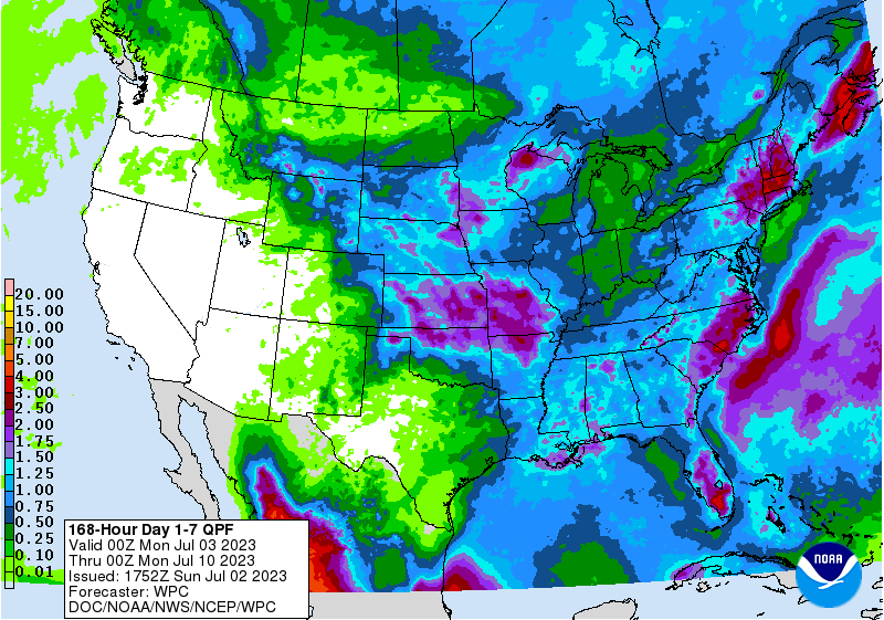
The high that’s been over us has mainly moved off to our east but yet their rain chances still look good. Ridiculous. Like I said a while back, the SE can be under a high and still get good rain.
And this is the next 7 days from the WPC:
-
Stratton20
- Posts: 4248
- Joined: Tue Feb 09, 2021 11:35 pm
- Location: College Station, Texas
- Contact:
Mother nature hates texas lol
That CPC forecast today looks hot hot hot lol
Popup thunderstorm headed towards me...then nope. Outflow. Gonna go around like every other time.


