Steve Copertino
@TheSteveCop
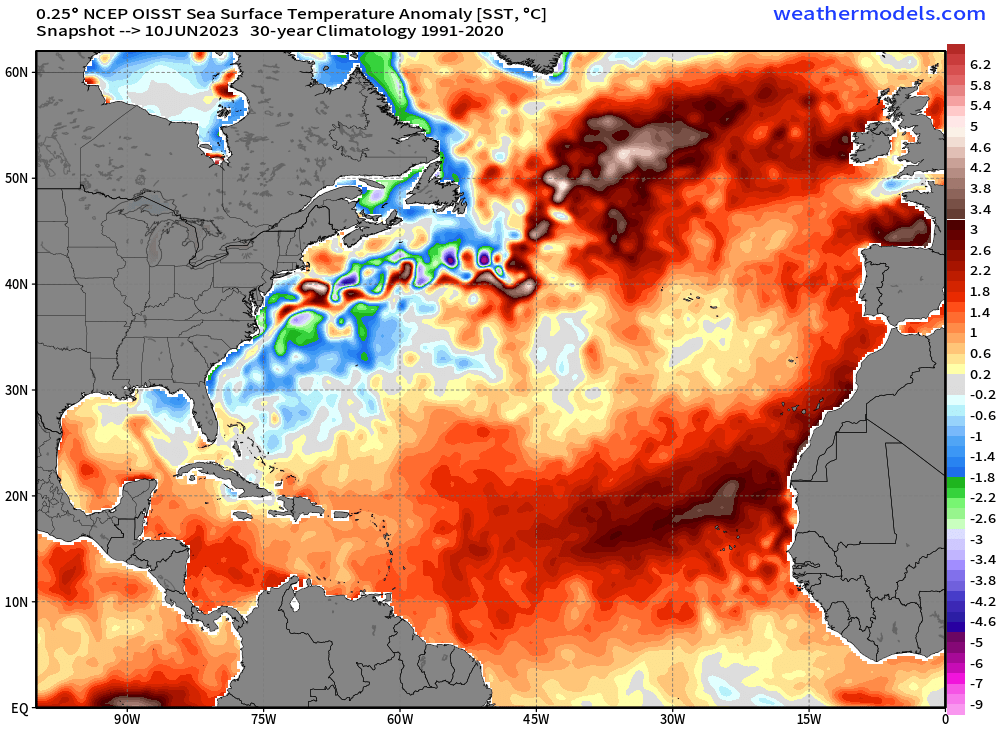
The warmth over the tropical Atlantic is just absurd at the moment. We're starting to see +3C anomalies pop over the EATL, with the 26°C isotherm already near the Cabo Verde islands thanks to major warming over the last 14 days.
I definitely think it could, Levi Cowan of Tropical Tidbits definitely said that is possible, also that cold pool of below normal water temps off the californian coast could actually slow down el nino from strengthening, my bet is an active season with what he has suggested
Area Forecast Discussion
National Weather Service Houston/Galveston TX
639 PM CDT Mon Jun 12 2023
...New AVIATION, CLIMATE...
.SHORT TERM...
(This evening through Tuesday Night)
Issued at 248 PM CDT Mon Jun 12 2023
In the near term, we`re keeping an eye on an outflow boundary
stretching from roughly the Toledo Reservoir to Mexia. Showers and
thunderstorms have blossomed along the eastern part of this
boundary. Whether capping will hold closer to Houston Co remains to
be seen, but have introduced slightly higher POPs (~ 30%) for that
general area and included the mention of the possibility of some
isolated severe cells with hail & downbursts the primary threat into
mid evening should anything pop.
Further upstream we`ll be watching for some additional development
where this boundary/front intersects the dryline in ncntl Tx.
General model consensus shows that storms along this feature should
either weaken or dissipate before approaching the northern part of
the CWA, but again left some lowish chances in the forecast given
some uncertainty.
For Tuesday, similar heights look to be in place that we saw today
and anticipate about the same high temps...maybe a degree or two
higher across sw/w parts where H85 temps climb another degree or
two. Heat index readings still look to peak in the 103-107 range so
will forego a heat advsy with this package. Will let the midnight
crew take another look at things...and moreso across western parts
of the CWA where it`s more borderline. Regardless, it`s gonna be hot
and an advsy will eventually be required in the coming days as H85
temps climb to obscene levels.
Additional storms look to fire to our north late Tue
afternoon...more than likely remaining to our north...but close
enough to our top tier of counties to maintain some isolated POPs
Tue evening. 47
&&
.LONG TERM...
(Wednesday through next Sunday)
Issued at 248 PM CDT Mon Jun 12 2023
Overall, trends in the long-term forecast continue to be defined
by the potential for an extended period of heat, with temperatures
pushing the triple digits across most of SE TX for the foreseeable
future. Depictions of the synoptic pattern remain relatively
unchanged across global models, with midlevel ridging continuing
to dominate just to our south while zonal flow remains in place
over SE TX. With 500mb heights pushing 595dam by Wednesday and
850mb temps remaining warm due to continued midlevel SW flow,
we`re looking at a prolonged period of dangerous heat by mid-week
that will last at least through the upcoming weekend.
NBM high temp distribution has remained similar to last night`s
run, and as a result have not strayed too far from the inherited
forecast. We continue to anticipate daytime highs in the 99-104
degree range across inland locations from Wed-Sun while coastal
locations will hover around the mid 90s. While daytime mixing
should drop dew points from the upper 70s in the morning to the
low/mid 70s during the afternoon, we will nonetheless see heat
index values in excess of advisory thresholds (108) by mid week
and approaching warning thresholds (113) by the end of the week
and into the weekend. Given this, heat safety actions will remain
critical. Taking proper precautions like avoiding strenuous
outdoor activity during the hottest parts of the day, remaining
properly hydrated by drinking plenty of water, and wearing light
and loose fitting clothing could be the difference between
experiencing and not experiencing heat stroke or heat exhaustion.
Given the dominance of ridging aloft, no rainfall is expected in
the extended period aside from the minimal chance of an isolated
pop-up storm during the afternoon. Rain-free conditions may
continue into next week.
Cady
&&
.AVIATION...
(00Z TAF Issuance)
Issued at 637 PM CDT Mon Jun 12 2023
Still keeping a close eye on our northern counties where an out-
flow boundary (from a large area of convection that moved just S
of the ArkLaTex region this afternoon) is currently sitting. Ad-
ditionally, yet another round of storms moving E/SE from the dry
line out west could have an outside chance of impacting our more
northern terminals (CLL/UTS) once again in these next few hours.
But, still not going to add any mention of thunder at this time.
Brief MVFR ceilings are possible late tonight through early Tues
morning with VFR conditions expected thereafter. Winds will most-
ly be from the south 4-9kts overnight to 9-14kts during the day.
41
&&
.MARINE...
Issued at 248 PM CDT Mon Jun 12 2023
An extended period of light to moderate onshore winds is expected
throughout the remainder of the week. Winds will increase slightly
to around 15-20kt by mid-week, potentially requiring cautions
and/or advisories. This increase in winds is expected to result in
seas building to around 4-5 feet. Winds and seas are expected to
decrease slightly heading into the weekend and the early part of
next week.
Cady
&&
.CLIMATE...
Issued at 637 PM CDT Mon Jun 12 2023
Here are the high temperatures records for the rest of the week.
College Station (CLL) (records date back to 1889):
-Tue (13th) 105 set in 1911
-Wed (14th) 107 set in 1998
-Thu (15th) 106 set in 1911
-Fri (16th) 104 set in 1901
Houston (IAH) (records date back to 1889):
-Tue (13th) 101 set in 1911
-Wed (14th) 102 set in 1998
-Thu (15th) 100 set in 2011
-Fri (16th) 100 set in 1902
Houston Hobby(HOU) (records date back to 1931):
-Tue (13th) 100 set in 2021
-Wed (14th) 101 set in 1998
-Thu (15th) 101 set in 1998
-Fri (16th) 100 set in 1963
Galveston (GLS)(records date back to 1874):
-Tue (13th) 97 set in 1911
-Wed (14th) 95 set in 2021
-Thu (15th) 93 set in 2022
-Fri (16th) 96 set in 1934
Palacios (PSX) (records date back to 1943):
-Tue (13th) 98 set in 2006
-Wed (14th) 97 set in 2021
-Thu (15th) 96 set in 1948
-Fri (16th) 93 set in 2022
Area Forecast Discussion
National Weather Service Houston/Galveston TX
637 AM CDT Tue Jun 13 2023
...New AVIATION, CLIMATE...
.SHORT TERM...
(Today through Wednesday Night)
Issued at 307 AM CDT Tue Jun 13 2023
The main message this week will continue to be hot and humid
conditions, making for uncomfortable afternoons as the heat index
values rise close to or exceeds 108°F in many areas.
Upper level ridge continues to control the larger scale pattern,
resulting in S to SW flow aloft. At the sfc, a quasi-stationary
boundary extending just north of our region will continue to induce
warm and more humid air into SE TX. Therefore, similar daytime
temperatures to yesterday can be expected today. Mid to high clouds
developing from north TX/SE OK in advance of an MCS could work into
our far northern counties this morning, potentially limiting the
warming some. Further to our west/southwest, mostly sunny skies
along with 850 temperatures into the 22 to 27 degC should lead to
heat indices up to 108°F. A Heat Advisory is in effect for
Colorado, Austin, Wharton and Jackson Counties. We`ll continue to
monitor trends during the day as the advisory could potentially
be expanded further north/east, depending on cloud cover.
A 30-35 knots low level jet is expected to develop late this
afternoon/early evening across our northern counties as heights
weaken a bit with passing weak shortwaves aloft. Any convection
looks to remain to our north; however, kept isolated rain/storm
chances given the amount of moisture and low-level instability.
The heat continues on Wednesday with mid to upper level ridging
continuing to dominate, becoming more zonal across SE TX. NAEFS and
GEFS guidance continue to show 850 mb temperatures in the MAX values
of climatology, suggesting well above normal temperatures. Highs
into the upper 90s to 100°F can be expected. Heat advisories will
likely be issued.
JM
&&
.LONG TERM...
(Thursday through Monday)
Issued at 307 AM CDT Tue Jun 13 2023
The long term outlook is quite simple and quite hot. Strong
mid/upper ridge of high pressure over Mexico will build northward
over Texas late in the week into early next week. The flow aloft
will remain generally out of the west, keeping 850mb temperature
anomalies well above average. Low-level onshore flow pushing Gulf
air into southeast Texas will enhance humidity. Dew points will
likely drop somewhat during the afternoon due to drier air mixing
down to the surface. But the humidity will remain more than
noticeable. Actual afternoon temperatures are expected to average
in the low-100s with overnight lows falling into the mid-70s to
low-80s. Areas near the coast will be a little cooler temperature
wise (mid-90s) but will also endure higher humidity. Heat index
values are expected to reach advisory level (108F) for most of the
CWA during this time frame and could reach warning criteria
(113F) in some locations.
Drinking plenty of water will be crucial this week. Also, it is
important to remember other hot weather safety measures such as
LOOK before you LOCK, wearing light colored and loose fitting
clothes, and remaining indoors during the hottest hours of the
days. Don`t forget that if it`s hot for you, then it is hot for
your pets. If the pavement is too hot for your feet, then it is
too hot for the paws.
Self
&&
.AVIATION...
(12Z TAF Issuance)
Issued at 617 AM CDT Tue Jun 13 2023
SCT to BKN MVFR ceilings can be expected this morning, gradually
scattering out after midday. Winds will strengthen during the
day, with gusts up to 20 knots possible in the afternoon. An
isolated shower or two will be possible near CLL and UTS terminals
later this afternoon; however did not mention VCSH/VCTS in TAFs
due to low confidence in occurrence. Another round of MVFR
ceilings can be expected later tonight.
&&
.MARINE...
Issued at 307 AM CDT Tue Jun 13 2023
Moderate onshore flow is likely through Thursday. Caution flag
level winds are likely, especially offshore. Winds could
potentially reach advisory criteria this evening into tonight
offshore while the bays are more likely to have caution flag level
winds. Seas are expected to be 3 to 5 feet. By Friday and beyond,
winds are seas are expected to decrease somewhat. However, caution
flags may still be warranted at times.
&&
.CLIMATE...
Issued at 637 PM CDT Mon Jun 12 2023
Here are the high temperatures records for the rest of the week.
College Station (CLL) (records date back to 1889):
-Tue (13th) 105 set in 1911
-Wed (14th) 107 set in 1998
-Thu (15th) 106 set in 1911
-Fri (16th) 104 set in 1901
Houston (IAH) (records date back to 1889):
-Tue (13th) 101 set in 1911
-Wed (14th) 102 set in 1998
-Thu (15th) 100 set in 2011
-Fri (16th) 100 set in 1902
Houston Hobby(HOU) (records date back to 1931):
-Tue (13th) 100 set in 2021
-Wed (14th) 101 set in 1998
-Thu (15th) 101 set in 1998
-Fri (16th) 100 set in 1963
Galveston (GLS)(records date back to 1874):
-Tue (13th) 97 set in 1911
-Wed (14th) 95 set in 2021
-Thu (15th) 93 set in 2022
-Fri (16th) 96 set in 1934
Palacios (PSX) (records date back to 1943):
-Tue (13th) 98 set in 2006
-Wed (14th) 97 set in 2021
-Thu (15th) 96 set in 1948
-Fri (16th) 93 set in 2022
.AVIATION...
(18Z TAF Issuance)
Issued at 1236 PM CDT Tue Jun 13 2023
VFR conditions currently across SE Texas with S winds at 10-15 KTS
with a few infrequent gusts of 18-25 KTS. An isolated SH/TS could
move in or near CLL/UTS later this afternoon or evening. Winds
will relax to 5-10 KTS tonight and MVFR cigs are possible
overnight into Wed morning. Some isolated patchy fog is possible
in areas where winds are below 7 KTS. Cigs will lift and scatter
and winds will strengthen to 10-15 KTS with gusts up to 25 KTS at
times during the morning hours.
I am encouraged what im seeing in the ensemble guidance, especially the EPS which is the best for upper level pattern recognition , the EPS is now shifting or showing the placement of the death ridge further west out in west texas and mexico and not directly over us, could open the door to easterly disturbances moving in and potentially providing rain chances again after the 10 day period, thats when the EPS suggests the ridge will be on the move and instead will build over new mexico/ mexico
The canadian ensemble agrees with the EPS
Last edited by Stratton20 on Tue Jun 13, 2023 3:23 pm, edited 1 time in total.
Area Forecast Discussion
National Weather Service Houston/Galveston TX
312 PM CDT Tue Jun 13 2023
...New SHORT TERM, LONG TERM, MARINE...
.SHORT TERM...
(This evening through Wednesday Night)
Issued at 247 PM CDT Tue Jun 13 2023
Tranquil weather conditions are expected tonight into Wednesday as
mostly zonal flow aloft is expected over Southeast Texas and a broad
mid level high pressure remains situated over Mexico. Although a few
weak east moving upper level disturbances will pass through to our
north and could bring in an isolated shower or thunderstorm to our
northern counties, most of Southeast Texas should remain capped;
Thus, little to no rain is expected during the short term period.
Conditions will continue to get warmer during the next few days. The
highs on Wednesday will be in the upper 90s for much of the inland
portions and in the low to mid 90s for the coastal areas. Heat
indicies will climb to 106-110 deg F Wednesday afternoon. Therefore,
a Heat Advisory has been issued for much of Southeast Texas and is
in effect from 1 to 7 PM CDT.
Make sure to practice heat safety: Stay hydrated and take numerous
breaks in the shade or inside a cooler structure, limit your time
outdoors, use protective clothing and/or sunblock, do not leave
children or pets unattended while outdoors, never leave children or
pets unattended inside vehicles.
Stay Safe!
24
&&
.LONG TERM...
(Thursday through next Monday)
Issued at 247 PM CDT Tue Jun 13 2023
The period beginning Thursday and persisting into the early part
of next week (and possibly longer) is expected to be defined by
prolonged excessive heat that will require those across SE TX to
take proper safety precautions when heading outdoors. Overall,
global models continue to depict a similar synoptic pattern
compared to the past few days, and we remain confident in the
extended forecast as a result of this consistency. With midlevel
ridging dominating the area as 500mb heights remain in excess of
590dam, along with SW flow remaining in place at 850mb, the area
will enter into a period of potentially dangerous heat beginning
on Thursday. Daily high temperatures are expected to eclipse 100
across most inland locations by Thursday, while locations along
the immediate coast will hover in the mid to upper 90s. Continued
southerly surface flow will allow for a steady onshore moisture
transport, keeping dew points in the upper 70s. While dew points
will mix out into the lower 70s during the afternoon across much
of the area, this will still be sufficient enough to produce
maximum heat index values ranging from 108-114 through the
remainder of the week and into the weekend. As such, additional
Heat Advisories are likely and Excessive Heat Warnings are
possible through at least Monday. In terms of low temperatures,
most locations should remain in the upper 70s to around 80
throughout the duration of the extended period...around 7-10
degrees higher than normal for this time of year.
A fact not known to many is that heat is the number one weather-
related cause of injury and mortality across the U.S. each year
according to the CDC. As such, it will be critical to take heat-
related safety precautions during this time. Common safety actions
like remaining sufficiently hydrated with water, applying
sunscreen, wearing light and loosely fitting clothing, and
avoiding strenuous outdoor activity during the hottest parts of
the day (roughly noon-5p) will remain important. Furthermore, it`s
important to check in with those vulnerable to heat-related
illness, such as the elderly and any friends/relatives with
chronic health conditions.
Cady
&&
.AVIATION...
(18Z TAF Issuance)
Issued at 1236 PM CDT Tue Jun 13 2023
VFR conditions currently across SE Texas with S winds at 10-15 KTS
with a few infrequent gusts of 18-25 KTS. An isolated SH/TS could
move in or near CLL/UTS later this afternoon or evening. Winds
will relax to 5-10 KTS tonight and MVFR cigs are possible
overnight into Wed morning. Some isolated patchy fog is possible
in areas where winds are below 7 KTS. Cigs will lift and scatter
and winds will strengthen to 10-15 KTS with gusts up to 25 KTS at
times during the morning hours.
24
&&
.MARINE...
Issued at 247 PM CDT Tue Jun 13 2023
Moderate onshore winds are expected to continue over the next
several days, likely requiring additional caution flags. At
times, wind speeds may approach advisory thresholds though this
should not be long-lived. Seas will continue to build as a
result of the slight wind increase, remaining at around 3-5 feet
through the remainder of the week before slightly diminishing by
early next week. No thunderstorms are expected over the next week
across the bays and coastal waters.
Stratton20 wrote: ↑Tue Jun 13, 2023 3:20 pm
I am encouraged what im seeing in the ensemble guidance, especially the EPS which is the best for upper level pattern recognition , the EPS is now shifting or showing the placement of the death ridge further west out in west texas and mexico and not directly over us, could open the door to easterly disturbances moving in and potentially providing rain chances again after the 10 day period, thats when the EPS suggests the ridge will be on the move and instead will build over new mexico/ mexico
The canadian ensemble agrees with the EPS
In fact, the EPS is due for an upgrade sometime this summer. The ensemble member resolutions will each be enhanced far beyond the lower resolutions that they previously ran at.
jasons2k wrote: ↑Tue Jun 13, 2023 3:23 pmYou don’t see mammatus clouds very often in Florida. Hard to tell in the photo
Miami/Southeast Florida metro is the true tropical, cosmopolitan vibe in the CONUS. Everything else in the state seems more "generic Sunbelt/USA"(although Orlando and Tampa are making improvements too).
jasons2k wrote: ↑Tue Jun 13, 2023 3:23 pm
You don’t see mammatus clouds very often in Florida. Hard to tell in the photo
Cool. Gulf coast or Atlantic?
This week in Boca at the Boca Raton resort on the Atlantic. Next two weeks back to our place back in IRB on the west coast. Thank goodness for house sitters keeping the plants and lawn alive back in Texas. It looks brutal.
Nice! I just got back from Jupiter visiting my wife's family. I love that area. My father in law has a huge mango tree and it is loaded. I had to bring a few back with me!