
August 2022

Wheres all our rain for Tues/Wed??
Mike
Beaumont, TX
(IH-10 & College Street)
Beaumont, TX
(IH-10 & College Street)
Your so funny!!!!

Visible satellite is starting to look interesting for this afternoon.
I think we’re about to get a new invest pretty soon. I could see a lemon coming as soon as this afternoon especially if the Euro gets onboard.
Nada from that mess last night.
Well... Mr. iCylone and myself have been half *** chatting about a potential Caribbean system the last day or so that could be in a position to enter the gulf. Now we're both getting even more intrigued.
Go figure it's again the ICON leading the way....
Go figure it's again the ICON leading the way....
-
TexasBreeze
- Posts: 942
- Joined: Sun Sep 26, 2010 4:46 pm
- Location: NW Houston, TX
- Contact:
I had almost 2 inches last night! The little upper low to the north hangs around for a while longer in north Texas per gfs. The chances of rain continue for awhile!
Are you referring to the system the GFS has entering the GOM north of Cuba on 9/1.
Harris County gauge at White Oak Bayou and Fairbanks shows 2.40" last night. It was heavy!TexasBreeze wrote: ↑Tue Aug 23, 2022 12:19 pm I had almost 2 inches last night! The little upper low to the north hangs around for a while longer in north Texas per gfs. The chances of rain continue for awhile!
So… is this the event? This is it?
On satellite it appears to be drifting to the south.TexasBreeze wrote: ↑Tue Aug 23, 2022 12:19 pm I had almost 2 inches last night! The little upper low to the north hangs around for a while longer in north Texas per gfs. The chances of rain continue for awhile!
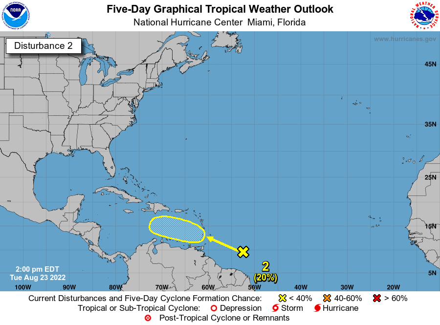
New lemon just as I suggested:
East of The Windward Islands:
A large area of disturbed weather has formed centered several
hundred miles east-southeast of the Windward Islands. While this
system is currently disorganized, environmental conditions could
become more conducive for development in a few days when the system
approaches the Windward Islands or southeastern Caribbean Sea.
* Formation chance through 48 hours...low...near 0 percent.
* Formation chance through 5 days...low...20 percent
Correct. We started casting a wary eye on it a few days back when the ICON was hinting at something. Then it was popping up on the background of the HWRF for 90l. Last night the Euro was showing the energy making it to the NW Caribbean.
Over the last 24 hrs steering in the medium range has started to get progressively more w. Enough that 'if' something were to form the general heading would be to the w or wnw towards either the eastern gulf or the yucatan. Of course tomorrow at this time the mid range steering could completely switch to ots.
Stick a fork in this non-event.

Honestly, from ABC13 to Space City Weather, all these forecasters just suck. All you see is lipservice and flimsy ad hoc justifications, there's no real substance at all.
NWS discussion tends to be the most informative. But even there, some of the same faults can occur, as seen in @Cromagnum's above screenshot.
NWS discussion tends to be the most informative. But even there, some of the same faults can occur, as seen in @Cromagnum's above screenshot.
-
Stratton20
- Posts: 4248
- Joined: Tue Feb 09, 2021 11:35 pm
- Location: College Station, Texas
- Contact:
12z Euro has the energy near the yucatan , but its still weak and broad, but this is typical given its very conservative history with developing tropical systems
-
tireman4

- Global Moderator

- Posts: 4488
- Joined: Wed Feb 03, 2010 9:24 pm
- Location: Humble, Texas
- Contact:
Let me come at this from another angle. It is Mother Nature. She fools us. We do not have meteorology down to a complete exact science. It happens. Even Wxman57 is wrong. He wont admit it..lol. Patience is a virtue. They have forgotten more than I know.
-
brazoriatx
- Posts: 329
- Joined: Tue Nov 08, 2011 12:09 pm
- Contact:
The hell you say! Wxman57 is the end all be all! He is ALWAYS right lol
Most of the time I just make my own forecast and mix it in a bit with what the mets are saying. I never expected much yesterday nor today so therefore I didn’t have my hopes up. I was telling everyone that it probably wasn’t gonna rain much today and to not believe the high rain chances. Tonight into tomorrow morning we’ll have a better chance.user:null wrote: ↑Tue Aug 23, 2022 1:56 pm Honestly, from ABC13 to Space City Weather, all these forecasters just suck. All you see is lipservice and flimsy ad hoc justifications, there's no real substance at all.
NWS discussion tends to be the most informative. But even there, some of the same faults can occur, as seen in @Cromagnum's above screenshot.
-
MontgomeryCoWx

- Posts: 2356
- Joined: Wed Dec 14, 2011 4:31 pm
- Location: Weimar, TX
- Contact:
Just because your home didn’t get what you expected doesn’t mean the forecast was wrong.
Since last Thursday, I’ve received 5.5 inches. Places as little as 15 miles away got around a inch.
My point is, if you live anywhere close to me, but got far less, your forecast was still pretty accurate. Forecasting and models isn’t a zero sum game.
Since last Thursday, I’ve received 5.5 inches. Places as little as 15 miles away got around a inch.
My point is, if you live anywhere close to me, but got far less, your forecast was still pretty accurate. Forecasting and models isn’t a zero sum game.
Team #NeverSummer