Hasn’t been that bad for me this year. It was borderline brutal a few times a couple weeks ago when we had a heat advisory for a day or two but outside of that, it’s been easier than usual.
August 2021: Major Hurricane Ida/SE Louisiana Landfall
-
Stratton20
- Posts: 4248
- Joined: Tue Feb 09, 2021 11:35 pm
- Location: College Station, Texas
- Contact:
12z CMC and GFS still showing a potential BOC system by day 9, CMC is a little more aggressive with development
I don’t see how it’s not that bad for you. Temps and dew points at your house are almost always 5 to 8 degrees more than almost anywhere else in southeast Texas.
- tireman4
- Global Moderator

- Posts: 4488
- Joined: Wed Feb 03, 2010 9:24 pm
- Location: Humble, Texas
- Contact:
Remember, different strokes for different folks. You maybe in better shape than I. You maybe quite younger than I . My pace is maybe slower ( 8:15 pace right now) than you.
- tireman4
- Global Moderator

- Posts: 4488
- Joined: Wed Feb 03, 2010 9:24 pm
- Location: Humble, Texas
- Contact:
000
FXUS64 KHGX 191741
AFDHGX
Area Forecast Discussion
National Weather Service Houston/Galveston TX
1241 PM CDT Thu Aug 19 2021
.AVIATION [18Z TAF Issuance]...
As high pressure and drier air pushes in from the southwest today,
most showers and thunderstorms this afternoon will be in our
eastern counties. Activity should diminish around sunset with the
loss of daytime heating. VFR conditions will prevail, but expect
brief MVFR ceilings and visibilities along with gusty winds should
a shower or storm pass over an airport. Overnight, MVFR ceilings
try to sneak down again for our northern sites, but should lift
back to VFR around 16Z.
KBL
-
Stratton20
- Posts: 4248
- Joined: Tue Feb 09, 2021 11:35 pm
- Location: College Station, Texas
- Contact:
Don yup this will be interesting to see how this all evolves over the next several days
Yeah, I'm trying to get rid of the COVID 19 (lbs). Relegated to walking the dog in the evening and jogging back with her. This summer has been better for weather...but we have 8-9 days of The Big Suck ahead before climo-ing into scattered showers and low 90s. That will be only 2-3 weeks of the Big suck. we *may* hit the Century mark next Wednesday. We'll see. That might be the 1st or 2nd summer in 30 years in BCS without reaching the 100°F mark.
tireman4 wrote: ↑Thu Aug 19, 2021 1:41 pm 000
FXUS64 KHGX 191741
AFDHGX
Area Forecast Discussion
National Weather Service Houston/Galveston TX
1241 PM CDT Thu Aug 19 2021
.AVIATION [18Z TAF Issuance]...
As high pressure and drier air pushes in from the southwest today,
most showers and thunderstorms this afternoon will be in our
eastern counties. Activity should diminish around sunset with the
loss of daytime heating. VFR conditions will prevail, but expect
brief MVFR ceilings and visibilities along with gusty winds should
a shower or storm pass over an airport. Overnight, MVFR ceilings
try to sneak down again for our northern sites, but should lift
back to VFR around 16Z.
KBL
Here comes the suck.
The one and only. The almost exact date that it develops is what popped in mind. No inference that anything similar will occur, just an observation in date and origination area (which Steve calls the 'Carla Cradle'.)captainbarbossa19 wrote: ↑Wed Aug 18, 2021 7:17 pmScott747 wrote: ↑Wed Aug 18, 2021 7:07 pm The 18z GFS is a mess. A few days ago it and the Euro were picking up on the meager wave that's currently at 50w. Euro has pretty much dropped it but as late as the 0z last night was oddly doing it. Now it's an early season like battle between the EPAC and BoC. Usually the EPAC wins out but it does appear a weak wave sets off the BoC. Getting in a range that it's not too outlandish but would definitely be an odd setup.
Also the GFS is running really low on some of the waves as the get through the Caribbean, or at least the energy is more on the southern axis of the waves. Sets one off of Columbia in the long range that lifts N. Let's not even get started on what originated down there a long time ago....
I take it that you are referring to a certain storm in the early 60s?
Outside of the 1900 storm and the 1886 Indianola storm (which changed history and allowed Galveston to go on and become the dominant port) Carla is our biggie in 'modern' times in impact and significance.
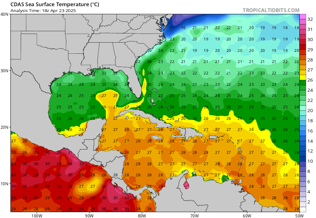
The western Gulf is just a little toasty 


-
Kingwood36
- Posts: 1592
- Joined: Sat Dec 29, 2018 10:29 am
- Location: Freeport
- Contact:
I've always wondered this..has Alaska ever been hit by a hurricane? Or is their water not warm enough to support a system?
-
Stratton20
- Posts: 4248
- Joined: Tue Feb 09, 2021 11:35 pm
- Location: College Station, Texas
- Contact:
CPV17 just a little bit toasty, just like bath water
 and Kingwood36 I dont that has ever happened, water temps that far north id imagine would never be warm enough for that
-
TexasBreeze
- Posts: 942
- Joined: Sun Sep 26, 2010 4:46 pm
- Location: NW Houston, TX
- Contact:
It sure has been consistently showing the system moving around slowly and having large eastern banding too, but the timeframe is staying around 10 days not sooner each run.
-
Stratton20
- Posts: 4248
- Joined: Tue Feb 09, 2021 11:35 pm
- Location: College Station, Texas
- Contact:
The 18z GFS continues to spin up something in the BOC about 8 days from now , what im a little concerned about is how the GFS has also been indicating that if this system forms, it could really be a slow mover or even stall , seems like it may indicate week steering currents, we will see
I’m noticing that too but if you look at the GEFS it actually starts showing the system in the sw Caribbean trying to come together at around the 180 hour mark or so. At least the 12 did. Haven’t checked the 18 yet.TexasBreeze wrote: ↑Thu Aug 19, 2021 6:27 pm It sure has been consistently showing the system moving around slowly and having large eastern banding too, but the timeframe is staying around 10 days not sooner each run.
-
Stratton20
- Posts: 4248
- Joined: Tue Feb 09, 2021 11:35 pm
- Location: College Station, Texas
- Contact:
CPV17 18z GEFS is about the same, around hour 180-192 is when development starts to occur near the yucatan before crossing into the BOC
interactive SST Anomaly maps with Google Maps interface https://coralreefwatch.noaa.gov/product ... om_level=4
they also have Google Earth interface https://coralreefwatch.noaa.gov/product/vs/map.php
they also have Google Earth interface https://coralreefwatch.noaa.gov/product/vs/map.php
The Japan current, like the Gulf Stream is quite warm. It arguably assists in making the Aleutian Islands/Peninsula and even to Juneau mild (relatively) during the winters. The Alaskan current though opposes it's direction (like the Labrador current on the NE coast. Remnants of TCs make their way to Alaska nearly every year. However, the sea temperature near Alaska is not nearly warm enough to sustain a tropical system.Kingwood36 wrote: ↑Thu Aug 19, 2021 4:56 pm I've always wondered this..has Alaska ever been hit by a hurricane? Or is their water not warm enough to support a system?
Late Fall the winter storms/cyclones (extra-tropical) are easily capable of producing hurricane force winds in the great Northwest.
Last edited by DoctorMu on Thu Aug 19, 2021 8:22 pm, edited 1 time in total.