
El Nino 3.4 continues to take a rapid dip now to -0.1 in cold neutral area.
http://www.cpc.ncep.noaa.gov/products/a ... ts-web.pdf
La Nina is forecast to be between Moderate and Strong
Here is the May update of all the ENSO models by IRI. A group is in Neutral and the other group is in La Nina.

El Nino 3.4 down to -0.2C in the latest update by Climate Prediction Center.
http://www.cpc.ncep.noaa.gov/products/a ... ts-web.pdf
http://www.cpc.ncep.noaa.gov/products/a ... ts-web.pdf
The Australians say La Nina is almost here.
http://www.bom.gov.au/climate/enso/
Issued on Wednesday 26 May 2010 | Product Code IDCKGEWWOO
Climate indicators across the equatorial Pacific are currently neutral. Equatorial Pacific Ocean temperatures, trade winds, the Southern Oscillation Index and cloudiness over the Pacific are all at levels considered typical of neutral conditions (i.e. neither El Niño nor La Niña).
Historically, about 35~40% of El Niño events are followed by a La Niña within the same year. Currently, a large volume of cooler than normal water is present below the surface of the equatorial Pacific Ocean, which indicates that further cooling of the surface of the tropical Pacific is likely.
International climate models predict continued cooling of the Pacific Ocean sea surface, with the majority of models surveyed by the Bureau predicting that this cooling will be sufficient to see the development of La Niña conditions later in the year. No climate models suggest a return to El Niño conditions. It should be noted that correctly predicting transitional periods of the El Niño Southern Oscillation is more difficult than predicting the continuation or decline of El Niño or La Niña events.
Climate Prediction Center Monthly update
La Nina between June-August timeframe.
http://www.cpc.ncep.noaa.gov/products/a ... odisc.html
La Nina between June-August timeframe.
http://www.cpc.ncep.noaa.gov/products/a ... odisc.html
Nino 3.4 down to -0.4C
Almost reaching La Nina now in this update by Climate Prediction Center.
http://www.cpc.ncep.noaa.gov/products/a ... ts-web.pdf
Almost reaching La Nina now in this update by Climate Prediction Center.
http://www.cpc.ncep.noaa.gov/products/a ... ts-web.pdf
Nino 3,4 down to -0.5C
Has reached la Nina threshold.
http://www.cpc.ncep.noaa.gov/products/a ... ts-web.pdf
Has reached la Nina threshold.
http://www.cpc.ncep.noaa.gov/products/a ... ts-web.pdf
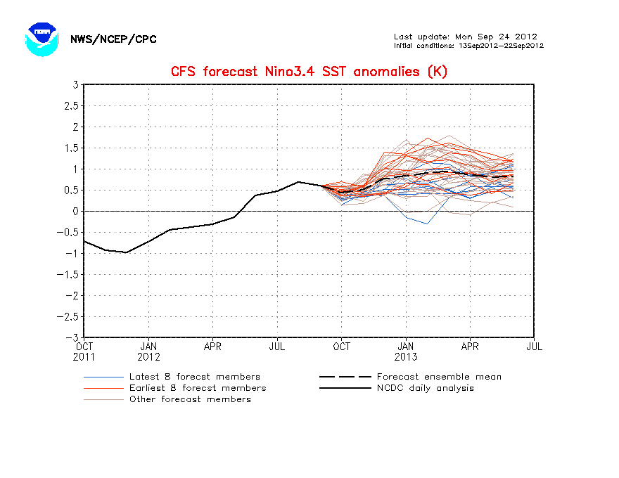
The CFS model is now forecassting Moderate to Strong La Nina by the peak of the season in ASO.
http://www.cpc.ncep.noaa.gov/products/a ... cast.shtml
http://www.cpc.ncep.noaa.gov/products/a ... cast.shtml
Climate Prediction Center's July Update says La Nina officially later this month or in August.
http://www.cpc.ncep.noaa.gov/products/a ... odisc.html
http://www.cpc.ncep.noaa.gov/products/a ... odisc.html
Synopsis: La Niña conditions are likely to develop during July - August 2010.
During June 2010, sea surface temperature (SST) anomalies continued to decrease across the equatorial Pacific Ocean, with negative anomalies expanding across the central and eastern Pacific (Fig. 1). While the rate of decrease slowed during June, all of the Niño indices were cooler compared to the previous month (Fig. 2). The subsurface heat content (average temperatures in the upper 300m of the ocean, Fig. 3) also remained below-average during the month. Subsurface temperature anomalies became increasingly negative in the east-central equatorial Pacific and extended to the surface across the eastern half of the basin (Fig. 4). Also during June, enhanced convection persisted over Indonesia, while the area of suppressed convection strengthened and expanded westward over the western and central equatorial Pacific (Fig. 5). Enhanced low-level easterly trade winds and anomalous upper-level westerly winds prevailed over the western and central equatorial Pacific. Collectively, these oceanic and atmospheric anomalies reflect developing La Niña conditions. .
The majority of models now predict La Niña conditions (SST anomalies less than or equal to -0.5oC in the Niño-3.4 region) to develop during June-August and to continue through early 2011 (Fig. 6). Confidence in this outcome is reinforced by the recent performance of the NCEP Climate Forecast System (CFS) (Fig. 7), the large reservoir of colder-than-average subsurface water (Fig. 3), and signs of coupling with the atmospheric circulation. Therefore, La Niña conditions are likely to develop during July-August 2010.
Weak La Nina is present according to the ENSO models. And the forecast for the next few months is for La Nina to hang on between Moderate and Strong.
http://iri.columbia.edu/climate/ENSO/cu ... nical.html
http://iri.columbia.edu/climate/ENSO/cu ... nical.html


The past El Nino is the strongest since 1997-98.
There is this ENSO dataset that goes back to 1868 from the Japanese Meteorological Agency.
ftp://www.coaps.fsu.edu/pub/JMA_SST_Ind ... y.filter-5
Don't know how good it is.
La Nina
<-20=Extremely Strong
-19.99 to -15=Strong
-14.99 to -10=Moderate
-9.99 to -5=Weak
-4.99 to +4.99=Neutral
El Nino
5 to 9.99=Weak
10 to 14.99=Moderate
15 to 19.99=Strong
>+20=Extremely Strong
The 30 day SOI index continues to skyrocket meaning La Nina continues to expand and get stronger. It was March 2008 the last time the over +20 was reached until now.

-
srainhoutx

- Site Admin

- Posts: 19616
- Joined: Tue Feb 02, 2010 2:32 pm
- Location: Maggie Valley, NC
- Contact:
I am amazed after a record winter and El Nino event that we have fallen to a Moderate La Nina quickly. The affects will take a bit of time, but the signals are interesting to say the least.
Carla/Alicia/Jerry(In The Eye)/Michelle/Charley/Ivan/Dennis/Katrina/Rita/Wilma/Humberto/Ike/Harvey
Member: National Weather Association
Facebook.com/Weather Infinity
Twitter @WeatherInfinity
Member: National Weather Association
Facebook.com/Weather Infinity
Twitter @WeatherInfinity

The strong La Niña of 73-74 followed the strong El Niño of 72-73, so it has definitely happened before, but it is indeed a fairly rare occurancesrainhoutx wrote:I am amazed after a record winter and El Nino event that we have fallen to a Moderate La Nina quickly. The affects will take a bit of time, but the signals are interesting to say the least.
With an upcoming strong La Niña in the cards, it is almost time to throw in the towel with regards to this winter. I hope everyone enjoyed the cold and snow across Texas of last winter, as we are about to witness the exact opposite...
Our only hope is for a strong area of high pressure to squeeze some of the arctic air into our area ala 88-89 (feb 89, several days below freezing) if we want to see anything remotely interesting that doesn't have to do with severe weather. La Niña's are notorious down here for keeping high heights across the south and especially across the SE, creating long stretches of highs in the 80s and lows in the 60s during the heart of winter with very little rainfall. I went back and looked at some of the daily temperatures at IAH during the strong events of 1973, 1975, and 1988, and ugh.... It is ugly. Composite all moderate and strong La Niñas for this area of Texas, and it isn't pretty.
But, it doesn't mean that we can't see a small period of interesting cold or snow (again, feb 89), but the general term to descirbe this upcoming winter will be "very warm"
-
sleetstorm
- Posts: 651
- Joined: Thu Feb 04, 2010 12:33 pm
- Contact:
So, this winter is looking to be much warmer than what Winter of 2009-2010 was, correct?Mr. T wrote:The strong La Niña of 73-74 followed the strong El Niño of 72-73, so it has definitely happened before, but it is indeed a fairly rare occurancesrainhoutx wrote:I am amazed after a record winter and El Nino event that we have fallen to a Moderate La Nina quickly. The affects will take a bit of time, but the signals are interesting to say the least.
With an upcoming strong La Niña in the cards, it is almost time to throw in the towel with regards to this winter. I hope everyone enjoyed the cold and snow across Texas of last winter, as we are about to witness the exact opposite...
Our only hope is for a strong area of high pressure to squeeze some of the arctic air into our area ala 88-89 (feb 89, several days below freezing) if we want to see anything remotely interesting that doesn't have to do with severe weather. La Niña's are notorious down here for keeping high heights across the south and especially across the SE, creating long stretches of highs in the 80s and lows in the 60s during the heart of winter with very little rainfall. I went back and looked at some of the daily temperatures at IAH during the strong events of 1973, 1975, and 1988, and ugh.... It is ugly. Composite all moderate and strong La Niñas for this area of Texas, and it isn't pretty.
But, it doesn't mean that we can't see a small period of interesting cold or snow (again, feb 89), but the general term to descirbe this upcoming winter will be "very warm"
-
srainhoutx
- Site Admin
- Posts: 19616
- Joined: Tue Feb 02, 2010 2:32 pm
- Location: Maggie Valley, NC
- Contact:
TROPICAL WEATHER OUTLOOK
NWS TPC/NATIONAL HURRICANE CENTER MIAMI FL
800 PM EDT THU JUL 29 2010
FOR THE NORTH ATLANTIC...CARIBBEAN SEA AND THE GULF OF MEXICO...
SHOWERS AND A FEW THUNDERSTORMS ASSOCIATED WITH A TROPICAL WAVE ARE
MOVING ACROSS THE WINDWARD ISLANDS. THERE ARE NO SIGNS OF
ORGANIZATION AT THIS TIME...AND ANY DEVELOPMENT OF THIS SYSTEM
IS EXPECTED TO BE SLOW TO OCCUR AS IT MOVES GENERALLY WESTWARD AT
10 TO 15 MPH. LOCALLY HEAVY RAINS AND STRONG GUSTY WINDS COULD
AFFECT PORTIONS OF THE LESSER ANTILLES OVER THE NEXT DAY OR SO.
THERE IS A LOW CHANCE...10 PERCENT...OF THIS SYSTEM BECOMING A
TROPICAL CYCLONE DURING THE NEXT 48 HOURS.
AN AREA OF DISTURBED WEATHER IS LOCATED OVER THE EASTERN ATLANTIC
OCEAN ABOUT 650 MILES SOUTHWEST OF THE CAPE VERDE ISLANDS. THIS
SYSTEM SHOWS SOME SIGNS OF ORGANIZATION...AND SLOW DEVELOPMENT OF
THIS DISTURBANCE IS POSSIBLE DURING THE NEXT COUPLE OF DAYS AS IT
MOVES SLOWLY TOWARD THE WEST OR WEST-NORTHWEST. THERE IS A LOW
CHANCE...20 PERCENT...OF THIS SYSTEM BECOMING A TROPICAL CYCLONE
DURING THE NEXT 48 HOURS.
ELSEWHERE...TROPICAL CYCLONE FORMATION IS NOT EXPECTED DURING THE
NEXT 48 HOURS.
$$
FORECASTER BEVEN
Carla/Alicia/Jerry(In The Eye)/Michelle/Charley/Ivan/Dennis/Katrina/Rita/Wilma/Humberto/Ike/Harvey
Member: National Weather Association
Facebook.com/Weather Infinity
Twitter @WeatherInfinity
Member: National Weather Association
Facebook.com/Weather Infinity
Twitter @WeatherInfinity
I think it will be a milder winter for 2010-11. Can't rule out a freeze or two.sleetstorm wrote: The strong La Niña of 73-74 followed the strong El Niño of 72-73, so it has definitely happened before, but it is indeed a fairly rare occurance
With an upcoming strong La Niña in the cards, it is almost time to throw in the towel with regards to this winter. I hope everyone enjoyed the cold and snow across Texas of last winter, as we are about to witness the exact opposite...
Our only hope is for a strong area of high pressure to squeeze some of the arctic air into our area ala 88-89 (feb 89, several days below freezing) if we want to see anything remotely interesting that doesn't have to do with severe weather. La Niña's are notorious down here for keeping high heights across the south and especially across the SE, creating long stretches of highs in the 80s and lows in the 60s during the heart of winter with very little rainfall. I went back and looked at some of the daily temperatures at IAH during the strong events of 1973, 1975, and 1988, and ugh.... It is ugly. Composite all moderate and strong La Niñas for this area of Texas, and it isn't pretty.
But, it doesn't mean that we can't see a small period of interesting cold or snow (again, feb 89), but the general term to descirbe this upcoming winter will be "very warm"
So, this winter is looking to be much warmer than what Winter of 2009-2010 was, correct?
Some of the most prolonged freezes occurred in La Nina winters, like January-February 1951 (longest freeze ever recorded) and February 1989 (second longest recorded) freeze. The February 1895, February 1899, and December 1989 Freeze were Neutral ENSO.
Interestingly, the winter of 1997-98 was not that cold despite a strong El Nino.
Considering 09-10 was the 6th coldest winter on record for Houston and we are entering a VERY unfavorable ENSO stage for cold across Texas, I'd say a forecast for a warmer winter this year would be of high confidence.sleetstorm wrote:
So, this winter is looking to be much warmer than what Winter of 2009-2010 was, correct?
La Niña winters tend to build up a lot of arctic air across the Northern Plains and Canada. For strong La Niña winters as a whole, the cold anomalies are usually found across the extreme North and West, with warm (very) anomalies across the South and East, with the warmest over the SE US (dominate SE ridge pattern). Of course, exact locations of these anomalies vary depending on other global indexes, but no matter how you slice it, Texas always ends up warm overallPtarmigan wrote:
Some of the most prolonged freezes occurred in La Nina winters, like January-February 1951 (longest freeze ever recorded) and February 1989 (second longest recorded) freeze. The February 1895, February 1899, and December 1989 Freeze were Neutral ENSO.
However, because so much cold air is bottled up north while we bake, sometimes the pattern will break for a short amount of time, and when this occurs the gates could open and allow an extremely cold airmass to descend upon our area like we saw in Feb 51 and Feb 89. It is usually a one and done type of event, with that being the only cold stretch we experience. The winter of 95-96, which was a weak La Niña, was quite volatile. Though because the ENSO remained weak, we were able to see several arctic airmasses make their way through the state. In February that winter, we saw highs reach 90 degrees and lows almost reach the teens. Unfortantely, this La Niña will be anything but weak. We will likely see many, many days in the 80s this upcoming winter (never fails in a strong La Niña ENSO event), but could we see a true arctic outbreak like Feb 89 for one short break in the winter?
Well, hell, I don't know. I hope so... I like how arctic airmasses did not have too much trouble passing through the state of Texas last year. Hopefully this is a sign that the global pattern is shifting back towards a colder phase for Texas winters like we saw in the 70s and 80s. I'm being extremely optimistic, sure... But, another arctic blast like we saw last January would be fun! I don't really like the cold, but extremes one way or the other are always interesting.
December 1997 was our 9th coldest on record, but after that we warmed up fast and stayed warm... A mostly postivie AO and awful Pacific pattern (raging Pacific jet, +EPO, second half of winter) led to huge warm anomalies for the northern US for the winter.Interestingly, the winter of 1997-98 was not that cold despite a strong El Nino.
Last edited by Mr. T on Fri Jul 30, 2010 3:57 am, edited 1 time in total.
We've seen four strong La Niña events since reliable SST data began in 1950. 1955-56, 1973-74, 1975-76, and 1988-89. Here is how temp anomalies look across the US when you put those together. Texas cold lovers should look away:
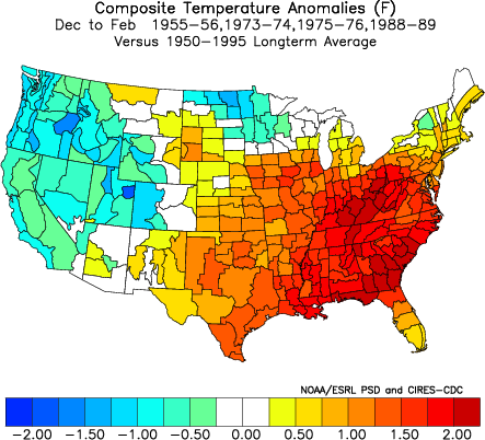
SE ridge ahoy! (could be good for ice storms around here with the right setup, hint hint 1989)
SE ridge ahoy! (could be good for ice storms around here with the right setup, hint hint 1989)