General Tropical Discussion Thread

Tropical Weather Discussions and Analysis
Post Reply
User avatar
srainhoutx
Site Admin
Site Admin
Posts: 19616
Joined: Tue Feb 02, 2010 2:32 pm
Location: Maggie Valley, NC
Contact:

With the 2010 Tropical Season underway, perhaps a Topic to discuss general tropical weather and waves that we will be watching is in order. We encourage folks to be a part of our discussions. This wave exited off Africa last week and has somewhat survived the trek across the Atlantic.

Image

ZCZC MIATWOAT ALL
TTAA00 KNHC DDHHMM
TROPICAL WEATHER OUTLOOK
NWS TPC/NATIONAL HURRICANE CENTER MIAMI FL
800 AM EDT WED JUN 9 2010

FOR THE NORTH ATLANTIC...CARIBBEAN SEA AND THE GULF OF MEXICO...

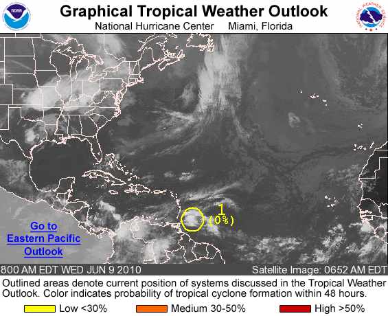
1. A TROPICAL WAVE MOVING WESTWARD ACROSS THE WINDWARD ISLANDS IS
PRODUCING SHOWERS AND GUSTY WINDS. THIS WEATHER SYSTEM IS EXPECTED
TO CONTINUE WESTWARD ACROSS THE SOUTHEASTERN CARIBBEAN WITH NO
ADDITIONAL DEVELOPMENT. THERE IS A LOW CHANCE...NEAR 0
PERCENT...OF THIS SYSTEM BECOMING A TROPICAL CYCLONE DURING THE
NEXT 48 HOURS.

ELSEWHERE...TROPICAL CYCLONE FORMATION IS NOT EXPECTED DURING THE
NEXT 48 HOURS.

$$
FORECASTER AVILA/LANDSEA
Carla/Alicia/Jerry(In The Eye)/Michelle/Charley/Ivan/Dennis/Katrina/Rita/Wilma/Humberto/Ike/Harvey

Member: National Weather Association
Facebook.com/Weather Infinity
Twitter @WeatherInfinity
User avatar
wxman57
Global Moderator
Global Moderator
Posts: 2621
Joined: Thu Feb 04, 2010 5:34 am
Location: Southwest Houston (Westbury)
Contact:

It appears to be something else ahead of this wave that the GFS is developing. I tracked the low-level vorticity from the wave approaching the Caribbean (circled on the image below) and the GFS develops something out ahead of it, apparently out of thin air. The wave does reach the GFS low on Monday and it appears to enhance it, though. I have been saying to watch out around the 13th of the month as wind shear drops off in the western Caribbean. So we'll have to keep an eye on this one. Good news is that all models have a ridge planted over south Louisiana for the next 7 days. That would mean a W-WNW track across the Yucatan and into Mexico should it spin up.

Image
User avatar
srainhoutx
Site Admin
Site Admin
Posts: 19616
Joined: Tue Feb 02, 2010 2:32 pm
Location: Maggie Valley, NC
Contact:

Increase to 10% chance of development...wxman57's weekend off in jeopardy... :?:

TROPICAL WEATHER OUTLOOK
NWS TPC/NATIONAL HURRICANE CENTER MIAMI FL
200 PM EDT WED JUN 9 2010

FOR THE NORTH ATLANTIC...CARIBBEAN SEA AND THE GULF OF MEXICO...

1. A LARGE AREA OF CLOUDINESS AND SHOWERS MOVING WESTWARD ACROSS THE
WINDWARD ISLANDS AND THE SOUTHEASTERN CARIBBEAN SEA IS ASSOCIATED
WITH A TROPICAL WAVE. SURFACE PRESSURES REMAIN HIGH AND UPPER-LEVEL
WINDS ARE NOT CURRENTLY FAVORABLE FOR SIGNIFICANT DEVELOPMENT.
THERE IS A LOW CHANCE...10 PERCENT...OF THIS SYSTEM BECOMING A
TROPICAL CYCLONE DURING THE NEXT 48 HOURS.

ELSEWHERE...TROPICAL CYCLONE FORMATION IS NOT EXPECTED DURING THE
NEXT 48 HOURS.

$$
FORECASTER AVILA/LANDSEA
Carla/Alicia/Jerry(In The Eye)/Michelle/Charley/Ivan/Dennis/Katrina/Rita/Wilma/Humberto/Ike/Harvey

Member: National Weather Association
Facebook.com/Weather Infinity
Twitter @WeatherInfinity
User avatar
Paul
Posts: 535
Joined: Wed Feb 03, 2010 11:46 pm
Location: Pearland
Contact:

nice Ed..very nice...
User avatar
desiredwxgd
Posts: 125
Joined: Wed Feb 03, 2010 6:30 pm
Location: TX/LA/Southern New England
Contact:

Ed Mahmoud wrote:My unofficial reading of JB is that he is still in "Tofu Pup" for this wave, but will probably raise the alert level to at least "Wiener" for the second half of June.
3) The tropical wave approaching the islands is the first one from the African wave train that has started growing before reaching the islands. This may have a relatively far south southern track, but it still may get into the Gulf next week. Waves following should track a bit farther north as the month progresses.
Ed- All I can say is, you make me laugh!! :lol:
JMS
SR. ENSC.
User avatar
srainhoutx
Site Admin
Site Admin
Posts: 19616
Joined: Tue Feb 02, 2010 2:32 pm
Location: Maggie Valley, NC
Contact:

TROPICAL WEATHER OUTLOOK
NWS TPC/NATIONAL HURRICANE CENTER MIAMI FL
800 PM EDT WED JUN 9 2010

FOR THE NORTH ATLANTIC...CARIBBEAN SEA AND THE GULF OF MEXICO...

A LARGE AREA OF CLOUDINESS...SHOWERS...AND THUNDERSTORMS MOVING
WESTWARD ACROSS THE WINDWARD ISLANDS AND THE SOUTHEASTERN CARIBBEAN
SEA IS ASSOCIATED WITH A TROPICAL WAVE. SURFACE PRESSURES REMAIN
HIGH AND UPPER-LEVEL WINDS ARE NOT FAVORABLE FOR SIGNIFICANT
DEVELOPMENT AT THIS TIME. THERE IS A LOW CHANCE...10 PERCENT...OF
THIS SYSTEM BECOMING A TROPICAL CYCLONE DURING THE NEXT 48 HOURS.

ELSEWHERE...TROPICAL CYCLONE FORMATION IS NOT EXPECTED DURING THE
NEXT 48 HOURS.

$$
FORECASTER BROWN/KIMBERLAIN
Carla/Alicia/Jerry(In The Eye)/Michelle/Charley/Ivan/Dennis/Katrina/Rita/Wilma/Humberto/Ike/Harvey

Member: National Weather Association
Facebook.com/Weather Infinity
Twitter @WeatherInfinity
User avatar
Paul
Posts: 535
Joined: Wed Feb 03, 2010 11:46 pm
Location: Pearland
Contact:

its staying under the 50knot shear somewhat but I think any low level circulation is way out in front of the convection. Or better lack of convection. Needs to work its way into the Carib and see what happens...the CMC sniffing something...still think its a little early though...
User avatar
wxman57
Global Moderator
Global Moderator
Posts: 2621
Joined: Thu Feb 04, 2010 5:34 am
Location: Southwest Houston (Westbury)
Contact:

Ed Mahmoud wrote:Anybody think they raised it, not based on new model data or observed satellite data, but because circling an area in yellow and then assigning a 0% chance of development just looked funny?

And assigning a 0% chance of something happening to anything so tempts Murphy's Law?
That's what I was thinking. As you know, the NHC began issuing predicted percentages this season, and they haven't had much practice so far. I'm thinking that the first outlook was issued with the wave circled in yellow and given a number and a near 0% chance of development and someone else over there pointed out that if something is circled then it needs to have at least 10% associated with it. Otherwise, why circle it? So the choice was to either remove the yellow area or assign a non-zero percent chance of development.

Another thought is that they realized that there was zero chance of development today or tomorrow (the range of the outlook) but that it could have a shot at development down the road. So they circled it just to keep attention on the wave until it reaches a more favorable environment in 3-4 days. Maybe I'm giving them too much credit there, but that's what we do.
ticka1
Posts: 1265
Joined: Wed Feb 03, 2010 3:02 pm
Location: Baytown/Mont Belvieu
Contact:

Question is will July bring more activity or will it be pushed back to August/September?
biggerbyte
Posts: 1142
Joined: Thu Feb 04, 2010 12:15 am
Location: Porter, Texas. (Montgomery County)
Contact:

Maybe I'm being overly sensitive here..
Does anyone besides me find the graphic about homeland security to be offensive?
We have a serious problem with terrorist across the world, not to
mention their attempting to create another 9/11 in this country. Equating a hotdog to that risk is a bit over the top, don't you think? Not to mention the fact this graphic is posted in a weather forum for rating life taking hurricanes like Katrina.


What are you guys thinking?

Am I rightfuly irrritated and offended, or am I just confused about the purpose of what I'm seeing? No matter what the purpose of its use in here, whoever created this graphicic, is without a doubt, mocking this country, and the lives lost on 9/11.
User avatar
Paul
Posts: 535
Joined: Wed Feb 03, 2010 11:46 pm
Location: Pearland
Contact:

Nice derailment of the thread Ed..... :lol:

Back on topic, the low about to splash down off of Africa looks promising as well.....lets see if it fizzles....
User avatar
srainhoutx
Site Admin
Site Admin
Posts: 19616
Joined: Tue Feb 02, 2010 2:32 pm
Location: Maggie Valley, NC
Contact:

Let's keep things on Topic. Also the graphic that started this mess has been removed by agreement of the Admins. Now back on Topic.
Carla/Alicia/Jerry(In The Eye)/Michelle/Charley/Ivan/Dennis/Katrina/Rita/Wilma/Humberto/Ike/Harvey

Member: National Weather Association
Facebook.com/Weather Infinity
Twitter @WeatherInfinity
ticka1
Posts: 1265
Joined: Wed Feb 03, 2010 3:02 pm
Location: Baytown/Mont Belvieu
Contact:

Ed Mahmoud wrote:JB morning update says Euro model forecast for Atlantic Basin is 260% of normal for ACE. That would be an impressive season.
Can you please explain the 260% of normal for ACE?

Impressive waves ... for June 14th don't ya think?
ticka1
Posts: 1265
Joined: Wed Feb 03, 2010 3:02 pm
Location: Baytown/Mont Belvieu
Contact:

Thanks for the explanation Ed. Appreciate it.
biggerbyte
Posts: 1142
Joined: Thu Feb 04, 2010 12:15 am
Location: Porter, Texas. (Montgomery County)
Contact:

Wow!
User avatar
Paul
Posts: 535
Joined: Wed Feb 03, 2010 11:46 pm
Location: Pearland
Contact:

JB was on Hannity today...basically reguritating what he has said all year...active season...the only part that stuck with me was when he said the GOM could see 4-5 storms this season.....ugh....
rnmm
Posts: 352
Joined: Fri Feb 05, 2010 12:16 am
Location: Santa Fe, Texas
Contact:

If 92L does get into the GOM and tries to develop, where is it going to head? I just worry about the oil spill, but I don't wish a storm on anyone either....
My name is Nicole and I love weather!!
~~~~~~~~~~~~~~~~~~~~~~~~~~~~~~~~~~~~~~~~~~~~~~~~~~~~~~~~~~~~~~~~~~~~~~~~~~~~~~~~~~~~~~~~~~~~~~~~
Alicia, Allison, Rita, Ike
User avatar
srainhoutx
Site Admin
Site Admin
Posts: 19616
Joined: Tue Feb 02, 2010 2:32 pm
Location: Maggie Valley, NC
Contact:

rnmm wrote:If 92L does get into the GOM and tries to develop, where is it going to head? I just worry about the oil spill, but I don't wish a storm on anyone either....

Way too soon to know if this wave will even develop, much less where it may end up. Stay Tuned!
Carla/Alicia/Jerry(In The Eye)/Michelle/Charley/Ivan/Dennis/Katrina/Rita/Wilma/Humberto/Ike/Harvey

Member: National Weather Association
Facebook.com/Weather Infinity
Twitter @WeatherInfinity
rnmm
Posts: 352
Joined: Fri Feb 05, 2010 12:16 am
Location: Santa Fe, Texas
Contact:

srainhoutx wrote:
rnmm wrote:If 92L does get into the GOM and tries to develop, where is it going to head? I just worry about the oil spill, but I don't wish a storm on anyone either....

Way too soon to know if this wave will even develop, much less where it may end up. Stay Tuned!

Thank you, I understand the potential can go either way :D
My name is Nicole and I love weather!!
~~~~~~~~~~~~~~~~~~~~~~~~~~~~~~~~~~~~~~~~~~~~~~~~~~~~~~~~~~~~~~~~~~~~~~~~~~~~~~~~~~~~~~~~~~~~~~~~
Alicia, Allison, Rita, Ike
User avatar
srainhoutx
Site Admin
Site Admin
Posts: 19616
Joined: Tue Feb 02, 2010 2:32 pm
Location: Maggie Valley, NC
Contact:

Interesting discussion this afternoon from Austin/ San Antonio NWS...

AREA FORECAST DISCUSSION
NATIONAL WEATHER SERVICE AUSTIN/SAN ANTONIO TX
305 PM CDT FRI JUN 18 2010

.DISCUSSION...
LATE AFTEROON CONVECTION IS JUST EAST OF SOUTH CENTRAL TX COUNTIES
FOR NOW...BUT CUMULUS PATTERNS AND HIGH DEW POINTS SUGGEST BRIEF
ACTIVITY IS STILL POSSIBLE WEST TO NEAR I-35 FOR AN HOUR OR TWO.
INCREASING STABILITY FROM THE UPPER RIDGE AXIS OVER EAST TX WILL
KEEP WEEKEND RAIN CHANCES NIL. HIGHER THICKNESS VALUES OVER THE
CENTRAL US WILL CONTINUE TO HELP RELAX WINDS OVER TX...RESULTING
AND WARMER AND DRIER AFTERNOONS AND SLIGHTLY COOLER MIN TEMPS FROM
EARLIER THIS WEEK. STILL THE MOISTURE IN THE GROUND AND VEGETATION
WILL KEEP MOST HIGHS IN THE MID 90S FOR MUCH OF THE NEXT WEEK.
HIGHS COULD POTENTIALLY GO UP TOWARD TRIPLE DIGITS BY THE MIDDLE
OF NEXT WEEK...BUT A MORE EASTERLY LOW LEVEL FLOW AND A POSSIBLE
TUTT LOW SUGGESTS THE DAYTIME WARMING TREND WILL BE MORE SUBTLE.
THE LATE PERIOD PATTERN IS MORE FAVORABLE FOR TROPICAL WAVES AND
THERE ARE ALREADY SOME HINTS AT TROPICAL WAVE ACTIVITY HEADING
TOWARD TX LATE NEXT WEEK.
Carla/Alicia/Jerry(In The Eye)/Michelle/Charley/Ivan/Dennis/Katrina/Rita/Wilma/Humberto/Ike/Harvey

Member: National Weather Association
Facebook.com/Weather Infinity
Twitter @WeatherInfinity
Post Reply
  • Information
  • Who is online

    Users browsing this forum: No registered users and 23 guests