
I have no idea what you're talking about as I've seen sleet with surface temps in the upper-30s and snow with surface temps in the mid-30s.Katdaddy wrote:Yep I agree with Wxman57 and Paul. To get frozen precip in the Hou-Gal area you must have the depth of freezing temps at all layers of the atmosphere. Remember we at sea level.....very difficult to get snow.
More cold air on the way next week!?
-
HannahMontana
- Posts: 9
- Joined: Thu Feb 04, 2010 4:49 pm
- Contact:

-
wxman57

- Global Moderator

- Posts: 2621
- Joined: Thu Feb 04, 2010 5:34 am
- Location: Southwest Houston (Westbury)
- Contact:
Other than a few brief periods, it's looking like around the 17th or 18th of the month - another 10 days of clouds and cold rain first.ticka1 wrote:My question is when will the sun shine again?
-
HannahMontana
- Posts: 9
- Joined: Thu Feb 04, 2010 4:49 pm
- Contact:
I'm still not sure what you're talking about. Can you please explain what you mean by depth of the cold air? You said earlier that we need temps below freezing at all layers above the surface to see frozen precip...which is wrong. For one, sleet(a form of frozen precip) needs a pocket of above freezing temperatures in the lower-mid levels to even form in the first place. Second, I've seen snow in SE Texas with near surface temps in the mid-30s and h85 temps right at the freezing mark. If anything, the frozen precip. events that affect SE Texas are more likely to be marginal and have less "depth" to the cold air than places that typically see frozen precipitation.Katdaddy wrote:Its all about the depth of the cold air. You just said it perfectly.

I'm sorry to be a party pooper (though I cannot for the life of me understand why ANYONE would wish-cast for freezing precipitation in an area that is not prepared for it) but there is NOT going to be sleet, snow, freezing rain, freezing drizzle, etc. in Houston or Southeast Texas this week.
JMHO
JMHO

I think you are splitting hairs here. GENERALLY speaking you need below freezing temps aloft to form sleet and or snow. More so with snow than with sleet.HannahMontana wrote:I'm still not sure what you're talking about. Can you please explain what you mean by depth of the cold air? You said earlier that we need temps below freezing at all layers above the surface to see frozen precip...which is wrong. For one, sleet(a form of frozen precip) needs a pocket of above freezing temperatures in the lower-mid levels to even form in the first place. Second, I've seen snow in SE Texas with near surface temps in the mid-30s and h85 temps right at the freezing mark. If anything, the frozen precip. events that affect SE Texas are more likely to be marginal and have less "depth" to the cold air than places that typically see frozen precipitation.Katdaddy wrote:Its all about the depth of the cold air. You just said it perfectly.
The Dec snow event was a pefect example of the right conditionss aloft to support snow.
-
HannahMontana
- Posts: 9
- Joined: Thu Feb 04, 2010 4:49 pm
- Contact:
How am I splitting hairs? He made a statement that is factually wrong.Paul wrote:
I think you are splitting hairs here. GENERALLY speaking you need below freezing temps aloft to form sleet and or snow. More so with snow than with sleet.
The Dec snow event was a pefect example of the right conditionss aloft to support snow.
Katdaddy wrote: To get frozen precip in the Hou-Gal area you must have the depth of freezing temps at all layers of the atmosphere.
-
srainhoutx

- Site Admin

- Posts: 19616
- Joined: Tue Feb 02, 2010 2:32 pm
- Location: Maggie Valley, NC
- Contact:
Larry Cosgrove tonight in the Houston Examiner...very interesting...
http://www.examiner.com/x-3775-Houston- ... ary-8-2010
http://www.examiner.com/x-3775-Houston- ... ary-8-2010
Carla/Alicia/Jerry(In The Eye)/Michelle/Charley/Ivan/Dennis/Katrina/Rita/Wilma/Humberto/Ike/Harvey
Member: National Weather Association
Facebook.com/Weather Infinity
Twitter @WeatherInfinity
Member: National Weather Association
Facebook.com/Weather Infinity
Twitter @WeatherInfinity

Yes his thoughts are very interesting indeed,I guess he's thinking the system will be stronger and have colder air than the models are indicating...srainhoutx wrote:Larry Cosgrove tonight in the Houston Examiner...very interesting...
http://www.examiner.com/x-3775-Houston- ... ary-8-2010
-
biggerbyte
- Posts: 1142
- Joined: Thu Feb 04, 2010 12:15 am
- Location: Porter, Texas. (Montgomery County)
- Contact:
srainhoutx wrote:Larry Cosgrove tonight in the Houston Examiner...very interesting...
http://www.examiner.com/x-3775-Houston- ... ary-8-2010
We'll, although his forecast sounds exciting, and god knows i would love for it to turn out that way, or better, but even he is subject to error, this far out. This is four and five days out. I have to tell you though, at this point in time, if I were to reach out that far with a forecast, it would be somewhat mirrored. Just as with hurricanes, these things will always change. To predict precip. now almost surely means he will change his mind two days from now. Of course, he could change it to more of the frozen stuff, vs. less, or none. Lol
BB
-
srainhoutx
- Site Admin
- Posts: 19616
- Joined: Tue Feb 02, 2010 2:32 pm
- Location: Maggie Valley, NC
- Contact:
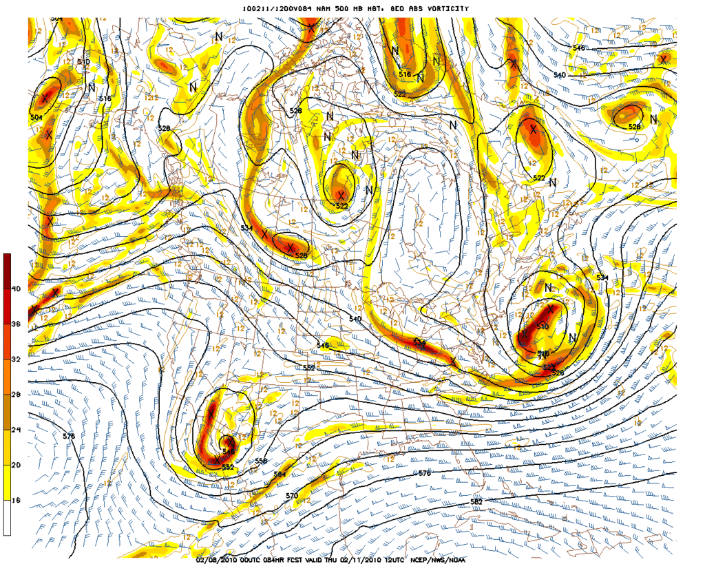
Even at hour 84, the 00Z NAM does look rather impressive and not a weak sheared out storm...
Edit: Oh and congrats Saints fans. Good Game!
Edit: Oh and congrats Saints fans. Good Game!
Carla/Alicia/Jerry(In The Eye)/Michelle/Charley/Ivan/Dennis/Katrina/Rita/Wilma/Humberto/Ike/Harvey
Member: National Weather Association
Facebook.com/Weather Infinity
Twitter @WeatherInfinity
Member: National Weather Association
Facebook.com/Weather Infinity
Twitter @WeatherInfinity
-
Portastorm

- Posts: 800
- Joined: Wed Feb 03, 2010 3:04 pm
- Location: Southwest Austin/Oak Hill, TX
- Contact:
OT -- Geaux Saints! Happy to see my boy Drew, the Saints, and Wxman57 have great cause to celebrate!
On to the weather -- new NAM has a slightly stronger, deeper upper level system compared to its 12z run.
On to the weather -- new NAM has a slightly stronger, deeper upper level system compared to its 12z run.
-
wxman57
- Global Moderator
- Posts: 2621
- Joined: Thu Feb 04, 2010 5:34 am
- Location: Southwest Houston (Westbury)
- Contact:
I had predicted 31-24 Saints. Now, I'll work a miracle for sleetstorm. I'll see if I can get him some sleet for next Friday morning. 
If the Saints can win the superbowl, then frozen precip can reach Houston.
Models should now have a pretty good handle on things. I'll check in tomorrow after the 12Z models.
If the Saints can win the superbowl, then frozen precip can reach Houston.
Models should now have a pretty good handle on things. I'll check in tomorrow after the 12Z models.
-
srainhoutx
- Site Admin
- Posts: 19616
- Joined: Tue Feb 02, 2010 2:32 pm
- Location: Maggie Valley, NC
- Contact:
Who Dat! Who Dat! Who Dat that took over wxman57's account!wxman57 wrote:I had predicted 31-24 Saints. Now, I'll work a miracle for sleetstorm. I'll see if I can get him some sleet for next Friday morning.
If the Saints can win the superbowl, then frozen precip can reach Houston.
Models should now have a pretty good handle on things. I'll check in tomorrow after the 12Z models.
Carla/Alicia/Jerry(In The Eye)/Michelle/Charley/Ivan/Dennis/Katrina/Rita/Wilma/Humberto/Ike/Harvey
Member: National Weather Association
Facebook.com/Weather Infinity
Twitter @WeatherInfinity
Member: National Weather Association
Facebook.com/Weather Infinity
Twitter @WeatherInfinity
-
sleetstorm
- Posts: 651
- Joined: Thu Feb 04, 2010 12:33 pm
- Contact:
I second that, HannahMontana.
-
weatherguy425
- Pro Met

- Posts: 830
- Joined: Wed Feb 03, 2010 7:45 pm
- Location: Atlanta, Georgia
- Contact:
hmm starting to get interesting at 72 hours...
http://www.nco.ncep.noaa.gov/pmb/nwprod ... p_072l.gif
PS had to just post the link because it cut of the USA when I posted the image?
http://www.nco.ncep.noaa.gov/pmb/nwprod ... p_072l.gif
PS had to just post the link because it cut of the USA when I posted the image?
Last edited by weatherguy425 on Sun Feb 07, 2010 10:03 pm, edited 1 time in total.
-
- Information
-
Who is online
Users browsing this forum: Ahrefs [Bot], Amazon [Bot], Bing [Bot], TexasBreeze and 109 guests