
Quite a shift eastward all night from the NHC tracks though. Last evening they projected it to be over western Uvalde County west of San Antonio, and it's now ~80 miles east of that. Probably more due to a north track than any strong eastward movement, but still produced an apparent east-of-track path due to the more northward component.Scott747 wrote:It's been confusing that some have seen this eastern movement when it has hardly shown much evidence of it since landfall. Steady N to NNW. Otherwise by now it would have been tracking more towards Austin. In some respects a track such of that may have lessened the rain in our area with the banding pushing a bit more towards Louisiana.
Tropical Storm Hermine Heavy Rain/Severe Threat
-
Met Tech

- Pro Met

- Posts: 40
- Joined: Sat Sep 04, 2010 9:32 am
- Location: North Platte, NE/ Sabinal, TX
- Contact:
Last edited by Met Tech on Tue Sep 07, 2010 12:58 pm, edited 2 times in total.
-
biggerbyte
- Posts: 1142
- Joined: Thu Feb 04, 2010 12:15 am
- Location: Porter, Texas. (Montgomery County)
- Contact:
This storm is sorta varying in movement. I've seen everything from
north, to nne, to even ne at times. At the moment it looks due north to me, but the next radar loop I check will likely show something different. At any rate, you can scratch off any westerly component from the path. It is north and east from here out.
It is raining very hard here in Porter. My roommate just called to tell me that Will Clayton and IAH area is flooded.
Folks, it does not look like the center will pass over our area, but there is going to be lots of rain and flooding. Top that off with a tornado watch and we have ourselves a messy day.
as posted by srainhoutx
Flash Flood Warning already posted. Serious rain happening. It will take a while to go anywhere. Let's hope this flash flooding doesn't happen - I'm downtown and don't want to be stranded. No matter where Hermine goes - the rain is here and its happening now!
Flash Flood Warning already posted. Serious rain happening. It will take a while to go anywhere. Let's hope this flash flooding doesn't happen - I'm downtown and don't want to be stranded. No matter where Hermine goes - the rain is here and its happening now!
Oh no doubt that it's well east of the NHC track and by a decent margin. As you mentioned and we were talking about late last night as we were tracking it, it's more a product of the northerly movement.Met Tech wrote:Quite a shift eastward all night from the NHC tracks though. Last evening they projected it to be over western Uvalde County west of San Antonio, and it's now ~80 miles east of that. Probably more due to a north track than any strong eastward movement, but still produced an east-of-track path.Scott747 wrote:It's been confusing that some have seen this eastern movement when it has hardly shown much evidence of it since landfall. Steady N to NNW. Otherwise by now it would have been tracking more towards Austin. In some respects a track such of that may have lessened the rain in our area with the banding pushing a bit more towards Louisiana.
I was popping off last night to Josh that I should have just hopped in the car and met Hermine on the 77 with how much it had showed movement to the N and how great it still looked.
-
srainhoutx

- Site Admin

- Posts: 19616
- Joined: Tue Feb 02, 2010 2:32 pm
- Location: Maggie Valley, NC
- Contact:
As has been mentioned, it is not often that we have a tropical system stay basically intact this far inland. As of the 1:00 PM Advisory, Hermine is still a Tropical Storm. That is around 18 hours if I recall correctly since landfall.
Carla/Alicia/Jerry(In The Eye)/Michelle/Charley/Ivan/Dennis/Katrina/Rita/Wilma/Humberto/Ike/Harvey
Member: National Weather Association
Facebook.com/Weather Infinity
Twitter @WeatherInfinity
Member: National Weather Association
Facebook.com/Weather Infinity
Twitter @WeatherInfinity
-
Andrew
- Site Admin
- Posts: 3440
- Joined: Wed Feb 03, 2010 9:46 pm
- Location: North-West Houston
- Contact:
Oh no doubt that it's well east of the NHC track and by a decent margin. As you mentioned and we were talking about late last night as we were tracking it, it's more a product of the northerly movement.Met Tech wrote:Quite a shift eastward all night from the NHC tracks though. Last evening they projected it to be over western Uvalde County west of San Antonio, and it's now ~80 miles east of that. Probably more due to a north track than any strong eastward movement, but still produced an east-of-track path.Scott747 wrote:It's been confusing that some have seen this eastern movement when it has hardly shown much evidence of it since landfall. Steady N to NNW. Otherwise by now it would have been tracking more towards Austin. In some respects a track such of that may have lessened the rain in our area with the banding pushing a bit more towards Louisiana.
I was popping off last night to Josh that I should have just hopped in the car and met Hermine on the 77 with how much it had showed movement to the N and how great it still looked.[/quote]
Yea last night I was seeing things . Defiantly a north movement.
For Your Infinite Source For All Things Weather Visit Our Facebook
-
Portastorm

- Posts: 800
- Joined: Wed Feb 03, 2010 3:04 pm
- Location: Southwest Austin/Oak Hill, TX
- Contact:
A number of reports coming in from SAT with some large limbs down and minor tree damage. Wind gusts into the 50s quite common along with torrential rain.
Here in AUS, we're seeing winds 15-20 sustained with gusts into the 30s. The rain has let up for a bit.
Here in AUS, we're seeing winds 15-20 sustained with gusts into the 30s. The rain has let up for a bit.

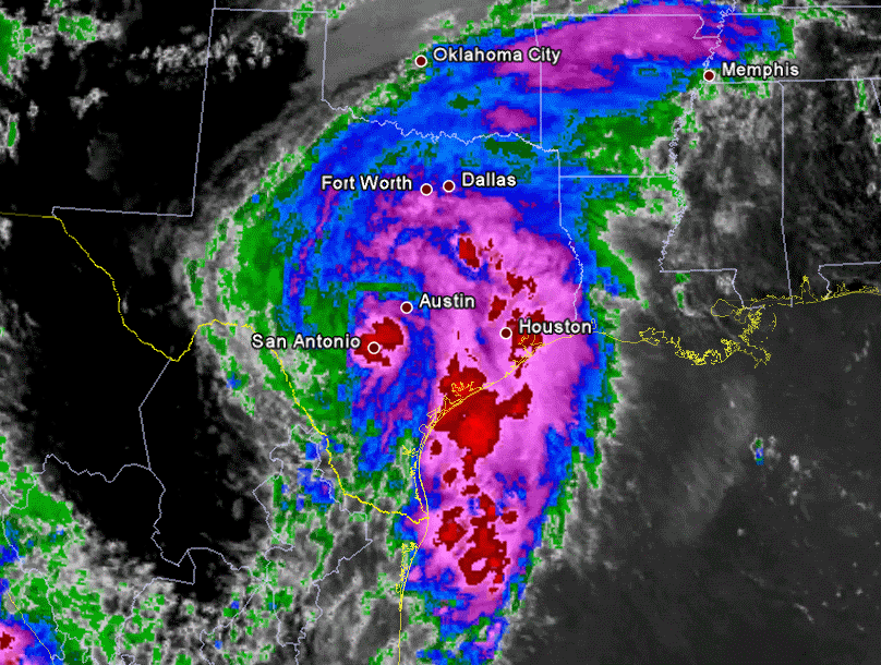
Still looks like a messy afternoon with more moderate to heavy rain moving into our southwest counties and lifting northeast slowly. The good news is that so far due to the quick storm motions and breaks between bands, flooding has been confined to the typical areas that flood during a heavy rain. The bayous are up and if we do see some more substantial rains, then more serious flooding will become a problem. Very deep tropical moisture continues to feed directly into the region this afternoon with PW's in the 2.2-2.5'' range supporting very hefty rain rates in the stronger storms.
Storm Total precip since 11pm yesterday evening. Wide View

Storm total precip Houston metro view

Storm Total precip since 11pm yesterday evening. Wide View
Storm total precip Houston metro view
What does it look like for the 5 rush hour? Is the worst over or do we have more coming...

Radar is lightning up some....good to see. Maybe rush hour won't be bad.
Email from Jeff Lindner:
Flash Flood event unfolding over TX as Hermine moves inland over SC TX.
Core of strong winds downing trees and power lines in the San Antonio area. Wind gusts to 57 mph in and around Bexar County.
Numerous flash flood warnings in effect for several locations with significant rises on rivers and creeks in progress.
Center of Hermine located NW of San Antonio and moving NNW at 15mph with large arcing feeder bands extending from near Waco SSE to off the upper TX coast. Radar rainfall rates of 4-6 inches have been recorded over much of SC TX and the coastal bend today and 2-3 inches locally over Harris County. Street flooding is in progress at several locations across the entire region.
The center of Hermine will continue to move into central TX tonight and N TX on Wednesday with training feeder bands continuing o move northward into the central and upper TX coast. Flood and flash flood threat will continue in all areas into Wednesday. Additional rainfall totals of 2-4” with isolated amounts upwards of 10 inches will be possible, especially over central TX where it appear likely that cores rainfall will evolve tonight.
Resultant river flooding/flash flooding across C TX is likely tonight into Wednesday and residents near/along rivers/creeks should remain up to date on rising water levels and NWS warnings.
Flash Flood Watch is extended for most of SE TX until Wednesday morning
New Tornado Watch is issues until 800pm for most of SE TX.
-
srainhoutx
- Site Admin
- Posts: 19616
- Joined: Tue Feb 02, 2010 2:32 pm
- Location: Maggie Valley, NC
- Contact:
Code: Select all
PRELIMINARY LOCAL STORM REPORT
NATIONAL WEATHER SERVICE HOUSTON/GALVESTON TX
254 PM CDT TUE SEP 07 2010

..TIME...   ...EVENT...      ...CITY LOCATION...     ...LAT.LON...
..DATE...   ....MAG....      ..COUNTY LOCATION..ST.. ...SOURCE....
            ..REMARKS..

1236 PM     MARINE TSTM WIND SAN LEON                29.49N 94.94W
09/07/2010  M41.00 MPH       GALVESTON          TX   ASOS

            EAGLE POINT MEASURED A WIND GUST OF 36 KNOTS.

0212 PM     MARINE TSTM WIND GALVESTON               29.30N 94.80W
09/07/2010  M53.00 MPH       GALVESTON          TX   ASOS

            GALVESTON PLEASURE PIER MEASURED WIND GUST OF 46 KNOTS.


&&

$$

OVERPECK
Carla/Alicia/Jerry(In The Eye)/Michelle/Charley/Ivan/Dennis/Katrina/Rita/Wilma/Humberto/Ike/Harvey
Member: National Weather Association
Facebook.com/Weather Infinity
Twitter @WeatherInfinity
Member: National Weather Association
Facebook.com/Weather Infinity
Twitter @WeatherInfinity
-
srainhoutx
- Site Admin
- Posts: 19616
- Joined: Tue Feb 02, 2010 2:32 pm
- Location: Maggie Valley, NC
- Contact:
HGX thoughts...
AREA FORECAST DISCUSSION
NATIONAL WEATHER SERVICE HOUSTON/GALVESTON TX
306 PM CDT TUE SEP 7 2010
.DISCUSSION...
CURRENT RADAR TREND SHOWS THE DEGREE OF PRECIP COVERAGE
DECREASING A LITTLE THE PAST COUPLE OF HOURS OVER THE AREA.
HOWEVER...STILL SEEING BANDS OF HVY RAINFALL DEVELOPING AND MOVING
INLAND FROM THE GULF. CONSIDERING THAT MOST OF THE WATCH AREA HAS
EXPERIENCED AT LEAST A COUPLE INCHES OF RAIN TODAY...IT WILL NOT
TAKE MUCH MORE RAINFALL TO CAUSE FLOODING PROBLEMS OVERNIGHT. THIS
IS ESPECIALLY TRUE FOR COASTAL SW COUNTIES AND URBAN PORTIONS OF
HARRIS COUNTY. SO...THE FLOOD WATCH WILL CONTINUE THROUGH 7 AM
WEDNESDAY WITH THE EXPECTATION THAT SOME AREAS COULD RECEIVE AN
ADDITIONAL 3 TO 5 INCHES OF RAINFALL TONIGHT. WILL ALSO ADD
MADISON AND WALKER COUNTIES TO THE WATCH. BEING ON THE EAST SIDE
OF HERMINE...WE ARE SEEING A UNIFORM SOUTHERLY FLOW OF 25-35 KTS
THROUGH THE LOW-MID LAYERS OF THE ATMOSPHERE AND THIS WILL KEEP
THE DEEP TROPICAL MOISTURE STREAMING IN OVERNIGHT. THE HVY
RAINFALL THREAT SHOULD GRADUALLY DECREASE ACROSS THE AREA TOMORROW
AFT AS HERMINE MOVES FURTHER N AWAY FROM THE REGION. BY LATE IN
THE AFTERNOON PW VALUES ARE EXPECTED TO DECREASE TO AROUND 2.0
INCHES...AS COMPARED TO THE 2.5 INCH PW AIRMASS THAT CURRENTLY
EXISTS OVR THE AREA.
DO NOT THINK THE TORNADO THREAT WILL EXTEND PAST THE WATCH TIME
FRAME (8 PM) AS LOW-LEVEL WIND FIELDS WILL GRADUALLY BECOME LESS
FAVORABLE AS HERMINE MOVES FURTHER NW AWAY FROM SE TX.
AFTER TOMORROW...MAX TEMPS ARE EXPECTED TO RETURN TO ABOVE NORMAL
LEVELS AS A RIDGE BEGINS TO BUILD OVER THE AREA. BY FRIDAY ONLY A
SLIGHT CHC OF RAIN IS IN THE FORECAST. SO EXPECT A MAINLY DRY AND
HOT WEEKEND COMING UP. 33
Carla/Alicia/Jerry(In The Eye)/Michelle/Charley/Ivan/Dennis/Katrina/Rita/Wilma/Humberto/Ike/Harvey
Member: National Weather Association
Facebook.com/Weather Infinity
Twitter @WeatherInfinity
Member: National Weather Association
Facebook.com/Weather Infinity
Twitter @WeatherInfinity
Seeing some discrete rotating cells developing out west across DeWitt, Lavaca, Gonzales, and Fayette counties with multiple tornado warnings going out.
2037 1 S MOULTON LAVACA TX 2956 9715 POSSIBLE TORNADO JUST SOUTH OF MOULTON NEAR THE INTERSECTION OF HIGHWAY 95 AND 271. LAW ENFORCEMENT REPORTS POWER LINES DOWN AND A PARTIAL ROOF ON THE ROAD.
2037 1 S MOULTON LAVACA TX 2956 9715 POSSIBLE TORNADO JUST SOUTH OF MOULTON NEAR THE INTERSECTION OF HIGHWAY 95 AND 271. LAW ENFORCEMENT REPORTS POWER LINES DOWN AND A PARTIAL ROOF ON THE ROAD.
-
Bluefalcon
- Posts: 129
- Joined: Fri Jun 25, 2010 6:14 pm
- Location: Round Rock, TX
- Contact:
Update from Round Rock/Austin. At the fire house tonight. My wife called and told me the gauge was full; thats 5 inches in East Round Rock. Crazy shift in downtown Austin. Fires, wrecks, water calls, ect... Had about 3.5 inches in the West Austin area. Hoping a core rain event happens someplace else, we're whipped from this afternoon's activities! 
Put the wet stuff on the red stuff!
Look like the rain event is over for us here in SE texas. Nothing on radar. Maybe storms will re-fire tomorrow while the sun shines...we escape another serious event and got some much needed rain.

I would watch out later tonight and overnight for redevelopment in the Gulf ....there is still a ton of moisture available out there and it won't take much to get it going again.
~~~When Thunder Roars Go Indoors~~~
~~~Turn Around Don't Drown~~~
~~~Run From The Water, Hide From The Wind~~~
~~~Turn Around Don't Drown~~~
~~~Run From The Water, Hide From The Wind~~~