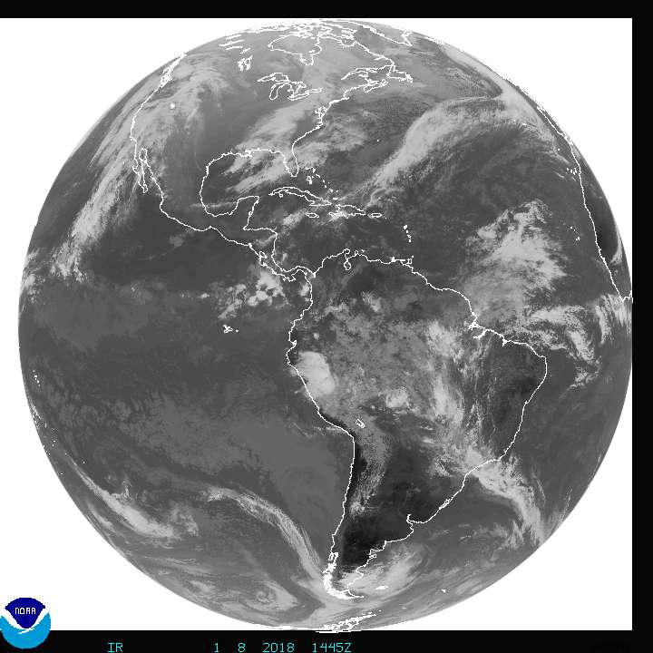
Southern South American weather systems
I have this desktop background called desktop earth it’s really cool and free. With it you can see really large storms that kind of look like hurricanes or nor’easters. Is there a name for them? How strong do they get? Wxman didn’t you start forcasting down there?
Those storms in Southern South America are extratropical low pressure systems, like we see here in the northern hemisphere. They are like northeasters. These storms are very large and they can be very intense with central pressure as low 920 millibars. I would not be surprised if they are low as 910 millibars. Also, they create a lot of windshear, which would partially explain why Southeastern Pacific and South Atlantic have little to no tropical cyclone development. Those extratropical systems make the Southern Ocean very stormy and dangerous for sailors. In addition, they give the southern area of South America a whole of rain, hail, and snow. That area are some of the stormiest places in the world. Up to 300 inches of rain falls per a year.
Thanks Ptarmigan
Is there a name for them?
Is there a name for them?
Your welcome. As far as I know, they are just extratropical low pressure systems. I don't know of any other names.DPD wrote:Thanks Ptarmigan
Is there a name for them?
Here is an article about an extratropical storm in the South Indian Ocean. The ones that hit southern South America circle Antartica making the Southern Ocean a very stormy place.
http://www.wunderground.com/blog/JeffMa ... 81&tstamp=
- wxman57
- Global Moderator

- Posts: 2621
- Joined: Thu Feb 04, 2010 5:34 am
- Location: Southwest Houston (Westbury)
- Contact:
Yes, my first job out of college in 1980 kept me way down south, as I always said I wanted to stay. But 53-54S is TOO far south! I was part of a team (of 2) meteorologists contracted out to Shell for gathering weather and current data on their Interocean-II rig that was drilling exploration wells about 20 miles east of the mouth of the Straits of Magellan. It was my first time in an airplane, too. Houston-Miami-Buenos Aires (sometimes Rio)- Comodoro Rivadavia - Rio Gallegos, then a 1.5 hr helicopter ride from Rio Gallegos to the rig. Quite a commute.DPD wrote:I have this desktop background called desktop earth it’s really cool and free. With it you can see really large storms that kind of look like hurricanes or nor’easters. Is there a name for them? How strong do they get? Wxman didn’t you start forcasting down there?
I was the only met on the rig. Had almost no data (1980). Shortwave radio was used to tune in a weather feed of surface obs that I had to plot by hand. No model data at all. No analyzed weather charts that far south to work with, either surface or upper air. Had an omnidirectional satellite antenna to pick up Polar orbiters every 1.5 hrs and a reel-to-reel tape recorder to record both a visible and IR image. But I had to be sitting at the shortwave radio to tune in the satellite each pass by hand. That meant no sleeping more than an hour if I wanted any pictures. Each shift was 28 days on / 28 off.
One trip down there we got into the center of a massive upper-level and surface low. It was a good 1000-1500 miles across. Winds/seas were nearly calm in the center for days, but winds on the periphery were 60 kts. One day, a smaller version of such a low passed overhead and I could see the little pointed "tail" above me that the satellite showed from above. When it moved off, winds picked up to 100+ kts for quite a while. Don't know how high they really got, as my anemometers were pegged out at 100 kts.
During the height of the storm I noticed that wave heights (had a waverider buoy and radio transmission to a plotter) dropped from 30ft to 25 ft almost instantly. There was only a 20 mile fetch across the water, so a 30 ft wave was incredible. But what happened to the waves? Why did they drop so fast with the wind going up? I went outside to see. The top 5 ft of the waves were being blown off as foamy spray by the wind. When I put my back to one of the railings and faced the wind, I could lift my feet off the deck and the wind held me up in the air.
Great memories from down there. I was amazed at how clear the air was. For example, at sunset here you can look almost directly at the orange sun without hurting your eyes. Down there, it's bright white all the way to the horizon and you can't look at it even if a tiny part of the sun is above the horizon. Sun would rise around 4am and set around 11pm. Long day.
Oh, to answer your question - there are no names for these storms.

If any one is interested there is one of these big lows approaching South America now but they get much bigger. I don’t know where to find satellite images of down there or I would try and post one.
Dan
Dan
- wxman57
- Global Moderator

- Posts: 2621
- Joined: Thu Feb 04, 2010 5:34 am
- Location: Southwest Houston (Westbury)
- Contact:
That's the trouble working down there - the GOES satellites are up at the Equator. You have to get Polar orbiting satellites that pass by every 90 minutes or so. Here's a GOES shot that shows the storm, though:

