


September 2020:
-
biggerbyte
- Posts: 1142
- Joined: Thu Feb 04, 2010 12:15 am
- Location: Porter, Texas. (Montgomery County)
- Contact:
It sure is trying tonight. Looking a bit better.
But that’s not moving West.

That's shear.Rip76 wrote: ↑Sat Sep 19, 2020 11:48 pmStill cruising NNE?DoctorMu wrote: ↑Sat Sep 19, 2020 11:32 pm Blowing up and major lightning closer to the center. Rumors of Beta's demise have been greatly exaggerated...
https://www.weathernerds.org/satellite/ ... nitsst=Off
Nocturnal core rainfall .. looks like a good setup for it no? With the center very near downtown?

The edge of tropical storm Beta is already showing up on local radar.
-
redneckweather
- Posts: 1022
- Joined: Mon Feb 08, 2010 7:29 pm
- Location: Montgomery, Texas
- Contact:
In other news, 63 degrees up here around Lake Conroe with a nice northerly breeze!
https://twitter.com/NWSHouston/status/1 ... 5437504512
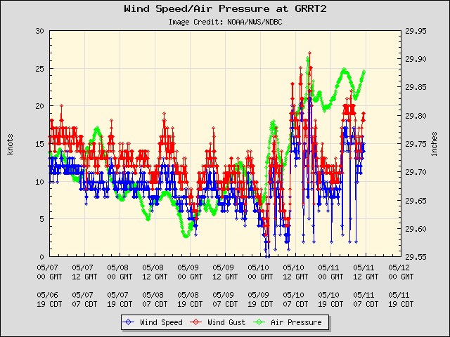
link to NDBC data for this site: https://www.ndbc.noaa.gov/station_page. ... tion=grrt2
Galveston Buoycam, Station 42035: https://www.ndbc.noaa.gov/station_page. ... tion=42035
Latest Image from 42035: https://www.ndbc.noaa.gov/buoycam.php?station=42035
@NWSHouston
Minor/Moderate Coastal flooding is currently ongoing!
The tide gauge at Galveston Railroad Bridge has seen water levels at 2.93ft above MHHW this morning - the highest water level this site has ever reported!
It should be noted this gauge has only been around since 2012. #GLSwx
link to NDBC data for this site: https://www.ndbc.noaa.gov/station_page. ... tion=grrt2
Galveston Buoycam, Station 42035: https://www.ndbc.noaa.gov/station_page. ... tion=42035
Latest Image from 42035: https://www.ndbc.noaa.gov/buoycam.php?station=42035
can also see data for this location at NOAA Tides and Currents - Beta https://tidesandcurrents.noaa.gov/inund ... /Beta.html
https://tidesandcurrents.noaa.gov/inund ... id=8771486
https://tidesandcurrents.noaa.gov/inund ... id=8771486
This storm is in opposite world. It dies down during DMax and flares up during DMin
Something weird is up with the new recon obs. Readings new hurricane force gusts. Not sure if it's rain contaminated. Also the center might be a little further nw.
-
TexasBreeze
- Posts: 942
- Joined: Sun Sep 26, 2010 4:46 pm
- Location: NW Houston, TX
- Contact:
It sure does look well organised south of Lake Charles. Mid level circulation on radar there in the middle of the storm cells?
-
Kingwood36
- Posts: 1592
- Joined: Sat Dec 29, 2018 10:29 am
- Location: Freeport
- Contact:
Anyone know where I can find radar to look at beta?
This is surprisingly a decent set of recon obs. It's far better than the entire mission last night. Definitely still a 50kt storm and they could even increase it a bit.
-
Stormlover2020
- Posts: 457
- Joined: Mon Jun 01, 2020 6:04 pm
- Contact:
Scott, is the new center farther north ?
I noticed on the WV loop this morning that some of that dry air looked like it was getting pushed back a bit.
-
weatherguy425
- Pro Met

- Posts: 830
- Joined: Wed Feb 03, 2010 7:45 pm
- Location: Atlanta, Georgia
- Contact:
As of now, no indication from the recon obs. Thought there was a hint of one just to the NW.
That's one hell of a vortex then because there were finding similar obs well removed from it to the w.