

I've had .97" here since midnight. A steady light to at times moderate rain. Nothing too heavy so far.
That dry air saved us. I was looking at the forecast soundings over Houston on the HRRR runs last night and saw quite a dry layer. It certainly did not look like a sounding from a tropical cyclone.
There will be some more localized flooding, and of course we have to keep a very close watch overnight tonight. However, if this had been a typical 'wet' tropical system, with this stall, we could have been looking at a major, widespread flooding event. Fortunately, that appears to not be the case here (so far).
September 2020:

With Beta still fighting off dry air on the SW side, it's become just a GoM firehose. Moderate rains, but slow moving. Localized flooding. The CoC appears to be just south of Victoria.
Hopefully, Beta drives a stake in the heart of summer.
Hopefully, Beta drives a stake in the heart of summer.
this looks pretty widespread to me
https://twitter.com/hcfcd/status/1308416722450472961
https://mrms.nssl.noaa.gov/qvs/mrms_v12 ... s_step=120
https://twitter.com/hcfcd/status/1308416722450472961
https://mrms.nssl.noaa.gov/qvs/mrms_v12 ... s_step=120


crazy how these "1,000 year floods" are happening almost every year now....

Looks like we are up next in Beaumont. Training band that got yall yesterday and lastnight just now entering Beaumont shortly. Hope to get some beneficial rain from it but I better be careful what I ask for. I remember Harvey and Imelda, Houston got it first then us the day after. Also, anyone notice the comparison of Harveys track and Betas track up the coast? Not saying anything, but eerily similar that Harvey track like this, Imelda similar and now Beta. Seems tropical systems nowadays dont want to travel into central or northern Texas to dissipate anymore. Stay safe everyone!
Mike
Beaumont, TX
(IH-10 & College Street)
Beaumont, TX
(IH-10 & College Street)
https://twitter.com/NWSWPC/status/1308436023928475650
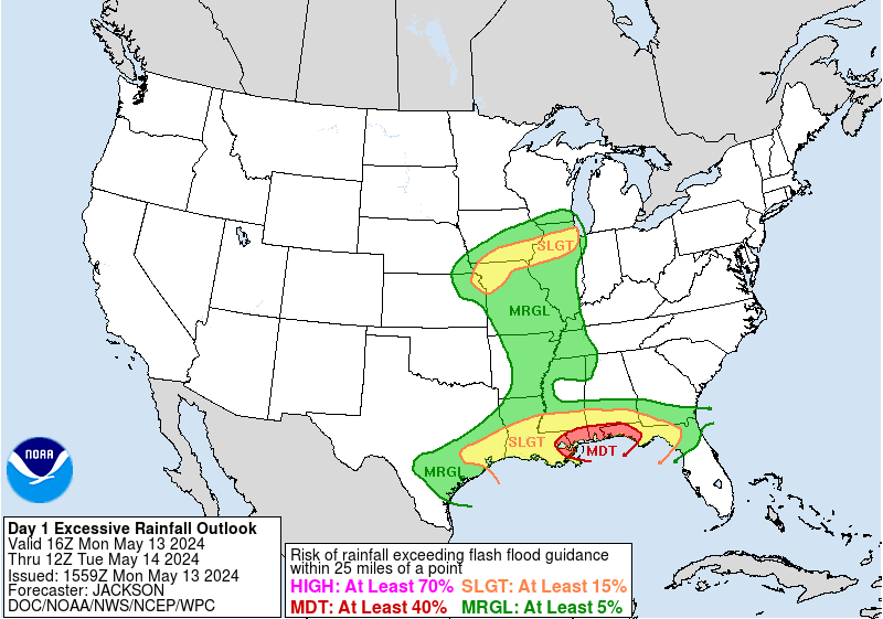
Excessive Rainfall Discussion
NWS Weather Prediction Center College Park MD
1203 PM EDT Tue Sep 22 2020
Day 1
Valid 16Z Tue Sep 22 2020 - 12Z Wed Sep 23 2020
...A HIGH RISK OF EXCESSIVE RAINFALL IS IN PLACE FOR PORTIONS OF
THE UPPER TEXAS COAST...
16z Update: No change needed to the risk areas at this time. Will
maintain a High risk in the vicinity of the Houston metro
area...where as much as 8-14 inches of rain has already fallen
just south of downtown Houston. Banding east of Beta has been a
bit less intense/persistent this morning...however still seeing
occasional hourly rainfall totals of 1-2" along the upper TX
coast. Most of the 12z CAMs, including recent HRRRv3 and HRRRv4
runs, suggest that convective banding near the center and east of
Beta becomes a bit better developed by late this afternoon trough
the evening hours as Beta moves eastward just inland of the coast.
Thus anticipating we see an increase in rainfall rates by this
period...with these higher rates likely moving across the Houston
metro and then up the coast towards Beaumont. An additional 3-6
inches of rain appears likely across this corridor...with
localized swaths of 6-10" a possibility. Still some uncertainty on
exactly how far inland this heaviest axis gets...as it should
focus right on the northern instability gradient just north of the
coastal front...where the strongest convergence overlaps with
marginal instability. Unclear if this will overlap the area of
south Houston that has been hardest hit (or end up just north and
east)...but either way would expect at least a couple inches of
additional rain here...with some potential of 5"+. Regardless, a
significant flash flood risk continues across the Moderate and
High risk areas of the Upper TX coast. The risk over southern LA
is less certain...but still enough uncertainty with convective
evolution to warrant maintaining continuity there.
Chenard
NWS Weather Prediction Center
@NWSWPC
A HIGH risk is in effect in our Day 1 Excessive Rainfall Outlook. More details: http://go.usa.gov/cu3Dw
Excessive Rainfall Discussion
NWS Weather Prediction Center College Park MD
1203 PM EDT Tue Sep 22 2020
Day 1
Valid 16Z Tue Sep 22 2020 - 12Z Wed Sep 23 2020
...A HIGH RISK OF EXCESSIVE RAINFALL IS IN PLACE FOR PORTIONS OF
THE UPPER TEXAS COAST...
16z Update: No change needed to the risk areas at this time. Will
maintain a High risk in the vicinity of the Houston metro
area...where as much as 8-14 inches of rain has already fallen
just south of downtown Houston. Banding east of Beta has been a
bit less intense/persistent this morning...however still seeing
occasional hourly rainfall totals of 1-2" along the upper TX
coast. Most of the 12z CAMs, including recent HRRRv3 and HRRRv4
runs, suggest that convective banding near the center and east of
Beta becomes a bit better developed by late this afternoon trough
the evening hours as Beta moves eastward just inland of the coast.
Thus anticipating we see an increase in rainfall rates by this
period...with these higher rates likely moving across the Houston
metro and then up the coast towards Beaumont. An additional 3-6
inches of rain appears likely across this corridor...with
localized swaths of 6-10" a possibility. Still some uncertainty on
exactly how far inland this heaviest axis gets...as it should
focus right on the northern instability gradient just north of the
coastal front...where the strongest convergence overlaps with
marginal instability. Unclear if this will overlap the area of
south Houston that has been hardest hit (or end up just north and
east)...but either way would expect at least a couple inches of
additional rain here...with some potential of 5"+. Regardless, a
significant flash flood risk continues across the Moderate and
High risk areas of the Upper TX coast. The risk over southern LA
is less certain...but still enough uncertainty with convective
evolution to warrant maintaining continuity there.
Chenard

How we looking for this afternoon. I know there will be more rain but, are we looking at last night's totals?
Been on conference calls all morning.
Been on conference calls all morning.
Still looks like there is plenty of moisture out into the GoM with the dry slot over the golden triangle area. I would expect the SW parts of the area to start filling in on radar. How heavy the rains will be is a big question mark.
http://tropic.ssec.wisc.edu/real-time/m ... anim=html5
http://tropic.ssec.wisc.edu/real-time/m ... anim=html5
It also appears the remnants of Beta are starting to move back towards the GoM per satellite.
Retrograding back to Matagorda Bay. That should increase pressure on the firehose.
About 0.9 in here for the duration, but rain is still coming down in teeny, tiny tropical droplets.
Sprinklers are finally officially off.
It looks good on visible satellite but is practically invisible on IR and water vapor.
-
Stormlover2020
- Posts: 457
- Joined: Mon Jun 01, 2020 6:04 pm
- Contact:
Hrr showing Hardin county could get hammered tonight and tomorrow

Any idea if Baytown will have heavy rains tonight?
-
tireman4

- Global Moderator

- Posts: 4471
- Joined: Wed Feb 03, 2010 9:24 pm
- Location: Humble, Texas
- Contact:
000
FXUS64 KHGX 221752
AFDHGX
Area Forecast Discussion
National Weather Service Houston/Galveston TX
1252 PM CDT Tue Sep 22 2020
.AVIATION [18Z TAF Issuance]...
Still getting those pesky IFR and MVFR ceilings from now Tropical
Depression Beta. As the center tracks along the souther CWA through
the next 24 hours, the winds in most flying areas are expected to
start shifting around. Lower ceilings are still expected as the
system tracks across the coast and lowered visibility will be mainly
associated with heavier rainfall. 35
.SHORT TERM [Today through Wednesday]...
Tropical Storm Beta made landfall Monday evening and is centered to
the west of the Edna area early this morning. Rainbands associated
with Beta`s circulation, similar to the ones that developed Monday
evening and caused flash flooding in/around the South Houston/Pearland/
Friendswood/League City areas, have continued to develop early this
morning with some in and around the same locations that received 5 to
8 inches of rain yesterday. Lots of short term and high resolution
models have been consistent in developing additional rainbands during
the remaining overnight hours and out through at least the morning hours.
If this pans out, especially over already hard hit locations, dangerous
flooding and flash flooding will occur, including on area creeks, bayous
and rivers. Beta`s slow forecasted movement over the next 24 to 36 hours
will favor additional banding development. If this happens, especially
over the same areas over and over again, dangerous flooding and flash
flooding could continue on into tonight and Wednesday morning, including
in and near locations that have been experiencing some surge related
flooding from this system. Additional rainfall totals of 5 to 10 inches
or more will be possible with the persistent banding, and this could
easily make Beta`s isolated totals reach or exceed 20 inches. 42
.LONG TERM [Wednesday Night through Tuesday]...
Beta (or what is left of Beta) will be working its way out of the
Southeast Texas area Wednesday night and Thursday. A drier
weather pattern looks to settle in behind this system for the
remainder of the week and into most of the weekend. We are still
seeing some model differences show up with their forecast of the
next cold fronts moving across Southeast Texas. Look for one to
possible edge across the area Sunday night followed by a second
one coming through on Tuesday. 42
&&
.PRELIMINARY POINT TEMPS/POPS...
College Station (CLL) 67 78 65 80 62 / 80 30 10 10 0
Houston (IAH) 71 79 68 82 67 / 90 60 20 10 10
Galveston (GLS) 76 83 73 83 74 / 90 60 30 20 10
&&
.HGX WATCHES/WARNINGS/ADVISORIES...
TX...Coastal Flood Warning until 7 AM CDT Wednesday for the following
zones: Brazoria Islands...Chambers...Coastal
Brazoria...Coastal Galveston...Coastal Harris...Coastal
Jackson...Coastal Matagorda...Galveston Island and Bolivar
Peninsula...Matagorda Islands.
High Rip Current Risk through Wednesday morning for the
following zones: Brazoria Islands...Galveston Island and
Bolivar Peninsula...Matagorda Islands.
Flash Flood Watch through Wednesday morning for the following
zones: Austin...Brazoria Islands...Chambers...Coastal
Brazoria...Coastal Galveston...Coastal Harris...Coastal
Jackson...Coastal Matagorda...Colorado...Fort
Bend...Galveston Island and Bolivar Peninsula...Inland
Brazoria...Inland Galveston...Inland Harris...Inland
Jackson...Inland Matagorda...Matagorda
Islands...Montgomery...Northern Liberty...Southern
Liberty...Waller...Wharton.
GM...Small Craft Advisory until 7 AM CDT Wednesday for the following
zones: Coastal waters from Freeport to Matagorda Ship
Channel TX out 20 NM...Coastal waters from High Island to
Freeport TX out 20 NM...Galveston Bay...Matagorda
Bay...Waters from Freeport to Matagorda Ship Channel TX
from 20 to 60 NM...Waters from High Island to Freeport TX
from 20 to 60 NM.
&&
$$
AVIATION...35
-
Texaspirate11

- Posts: 1278
- Joined: Tue Dec 31, 2013 12:24 am
- Contact:
WE certainly have been hammered here - Kemah.
Just because you're disabled, you don't have to be a victim
Be Weather Aware & Prepared!
Barbara Jordan Winner in Media
Disability Integration Consultant
Be Weather Aware & Prepared!
Barbara Jordan Winner in Media
Disability Integration Consultant

Don't let your guard down folks. There's a real possibility of core rains tonight as the center of Beta passes through. Especially for the central tier of counties.
Guess that afternoon core event was called too early. We'll see what happens tonight
-
TexasBreeze
- Posts: 942
- Joined: Sun Sep 26, 2010 4:46 pm
- Location: NW Houston, TX
- Contact:
That is some of the heavier core rains along I-10. The actual center is by Matagorda Bay moving east along the coast.