
April 2020
So looks like I'll be trying to knock out the backyard mowing early afternoon just in case.
I’m not impressed by the coverage of today’s event on the mesoscale models. They all show an isolated event and mostly just show areas north of 59 and north of 10 getting anything. South and east of there it looks pretty weak. Maybe light to moderate rain at best. For some reason the storms just want to die out according to the models I’m looking at. Colorado County, Austin, Waller, Harris (western/northern parts of the county), and Liberty Counties and points north of there look like areas that will get some rain/storms today.
Looks like outflow boundaries from last night's midwest storms are sinking through Louisiana this morning. Looked like some gravity waves out ahead of that as well, heading in this general direction. Wondering what impact, if any, that is going to have this afternoon.
All my weather apps just show 20-30% chance of light rain. I went ahead and mowed so that assured it will be sunny all day.

There will be storms today you can already see them on radar firing up in the hill county. Those supercells will slowly back build to the south and west as the afternoon progresses and form into a squall line/mesoscale convective system. I would say places along and north of the I-59 corridor have the best chances of seeing severe weather today.
- Attachments
-

It’s cloudy out there. That will limit the severity of today’s storms I’m sure.
-
Katdaddy

- Global Moderator

- Posts: 2502
- Joined: Thu Feb 04, 2010 8:18 am
- Location: League City, Tx
- Contact:
A Severe Thunderstorm Watch has been issued STX, S Central TX, and most of SE TX except the coastal counties until 10:00PM. Remain weather aware this evening and tonight.
URGENT - IMMEDIATE BROADCAST REQUESTED
Severe Thunderstorm Watch Number 97
NWS Storm Prediction Center Norman OK
245 PM CDT Thu Apr 9 2020
The NWS Storm Prediction Center has issued a
* Severe Thunderstorm Watch for portions of
South-central/Southeast Texas
* Effective this Thursday afternoon and evening from 245 PM until
1000 PM CDT.
* Primary threats include...
Scattered large hail likely with isolated very large hail events
to 3 inches in diameter possible
Scattered damaging winds and isolated significant gusts to 75
mph possible
A tornado or two possible
SUMMARY...Multiple corridors of strong to severe thunderstorms will
continue to intensify within an increasingly unstable environment,
with such initial development near the I-35 corridor through
mid/late afternoon. Supercells and well-organized clusters can be
expected with large hail and damaging winds possible as storms
spread east-southeastward toward east/southeast Texas and the
coastal plain through evening.
- Attachments
-
Is this one of those situations where there could be pop-ups ahead of the line or is the line the action as it traverses the state, possibly back building? Thanks.
Current run of the Texas Tech WRF seems like it's got a good handle on things. Cap is pretty solid, but seems to erode as the front approaches. Think we're looking at the typical linear event with gusty winds. I'm not as versed seeing hail potential, but my spidey-sense leans to maybe some small pea to dime size. I typically assimilate the golf ball and larger hail with more discrete cells, but that's just based on anecdotal memory.
https://www.wpc.ncep.noaa.gov/metwatch/ ... 33&yr=2020
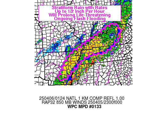
Mesoscale Precipitation Discussion 0133
NWS Weather Prediction Center College Park MD
307 PM EDT Thu Apr 09 2020
Areas affected...Portions of Central and Eastern TX
Concerning...Heavy rainfall...Flash flooding possible
Valid 091905Z - 100105Z
SUMMARY...Showers and thunderstorms will be increasing in coverage
and intensity this afternoon across portions of central and
eastern TX. Given very intense short-term rainfall rates, a few
incidences of flash flooding may result.
DISCUSSION...The latest WV/IR satellite imagery shows a broadly
diffluent flow pattern across the southern Plains with a
well-defined subtropical jet crossing from the eastern tropical
Pacific northeast across mainland Mexico and the Rio Grande
Valley. Weak shortwave energy embedded within the deep layer
southwest flow is seen beginning to interact with a frontal zone
draped over portions of central TX, along with an extremely
favorable thermodynamic environment that will be conducive for
widespread convection this afternoon and evening. In fact, radar
imagery is already showing a broken band of showers and
thunderstorms west of Waco and Austin, and to the south of
Brownwood with upscale growth and cloud-top cooling noted over the
last hour.
The activity is expected to grow further in coverage and
organization in the hours ahead as the convection interacts with
an environment characterized by MLCAPE values increasing to 3000
to 4000 j/kg, PWs approaching 1.5 inches, and 50 to 60 kts of
effective bulk shear. The low-level inflow ahead of this
afternoon's convection is not especially good, with values
generally under 20 kts, but there is decent frontal convergence
overall, and this coupled with the robust thermodynamic
environment and forcing aloft should still yield a well-organized
convective event with multiple evolving convective clusters and a
few cell-mergers.
The 12Z HREF mean favors as much as 2 to 3 inches of rain in as
little as 1 to 2 hours, and these intense rainfall rates will be
aided in part by the moist 500/300 mb layer eastern tropical
Pacific moisture transport regime that is in place, in addition to
very moist low-levels and the aforementioned instability.
Areas of central TX, especially closer into the Austin area have
been relatively wet over the last couple of weeks, and so this
coupled with the intense rain rates would favor some locally
enhanced runoff concerns. Thus, a few incidences of flash flooding
will be possible going through the afternoon and evening hours,
with an emphasis on the more sensitive urban centers and adjacent
suburbs. While the activity will be more focused on central TX
over the next couple of hours, areas farther east with time will
see the convective rainfall threat on the increase as well.
Orrison
ATTN...WFO...EWX...FWD...HGX...LCH...SHV...
ATTN...RFC...WGRFC...
-
Katdaddy
- Global Moderator
- Posts: 2502
- Joined: Thu Feb 04, 2010 8:18 am
- Location: League City, Tx
- Contact:
Wow, moving SE at 60MPH
Severe Weather Statement
National Weather Service Houston/Galveston TX
344 PM CDT Thu Apr 9 2020
TXC051-477-092115-
/O.CON.KHGX.SV.W.0016.000000T0000Z-200409T2115Z/
Burleson TX-Washington TX-
344 PM CDT Thu Apr 9 2020
...A SEVERE THUNDERSTORM WARNING REMAINS IN EFFECT UNTIL 415 PM CDT
FOR BURLESON AND CENTRAL WASHINGTON COUNTIES...
At 344 PM CDT, a severe thunderstorm was located near Caldwell,
moving southeast at 60 mph.
HAZARD...70 mph wind gusts and quarter size hail.
SOURCE...Radar indicated.
IMPACT...Hail damage to vehicles is expected. Expect considerable
tree damage. Wind damage is also likely to mobile homes,
roofs, and outbuildings.
Locations impacted include...
Brenham, Caldwell, Somerville, Snook, Burton, Lake Somerville Dam,
Lake Somerville State Park & Trailway, Carmine, Lyons, Deanville,
Independence, Quarry and Chriesman.
PRECAUTIONARY/PREPAREDNESS ACTIONS...
For your protection move to an interior room on the lowest floor of a
building.
This thunderstorm is capable of producing all types of severe weather
including extremely large hail, destructive straight line winds and
tornadoes. Move quickly to a safe shelter, such as an interior room,
a bathroom or closet or basement.

High cirrus clouds have been moving in from the SW all day, but that shouldn't change things as the atmosphere is pretty unstable at the moment and there's plenty of sun still breaking through getting temperatures to the upper 80s for most of our area. Sugar Land reporting 90F.
Our main threat here in Houston will be strong winds as the complex out towards Bryan looks to be getting its act together as it continues to move ESE toward our general area. Quarter size hail isn't out of the question in some of the more embedded thunderstorms along the line.
- Attachments
-
- Visibile Satellite
Blake
Boomer Sooner
Boomer Sooner

Those cells near Brenham look nasty, and right-turners as well.
Outflow boundary looks to be racing out ahead of the front which should undercut any tornado threat. Though that will likely kick off new storms out ahead of the main thunderstorm complex and those discreet cells that develop will have the potential for some larger hail.
- Attachments
-
- Radar
Blake
Boomer Sooner
Boomer Sooner
College Station getting smoked right now.
So I wasn't completely coming out of left field on my thinking. I was hoping you would chime in. My knowledge and experience is mostly anecdotal, but I've tried to pay attention and analyze concurrently.Belmer wrote: ↑Thu Apr 09, 2020 4:21 pm Outflow boundary looks to be racing out ahead of the front which should undercut any tornado threat. Though that will likely kick off new storms out ahead of the main thunderstorm complex and those discreet cells that develop will have the potential for some larger hail.
All of it looks to head well North of us all.