February 2020

General Weather Discussions and Analysis
User avatar
jasons2k
Posts: 5381
Joined: Thu Feb 04, 2010 12:54 pm
Location: Imperial Oaks
Contact:

unome wrote: Wed Feb 05, 2020 11:53 am there is no longer a "wintry mix" icon in our HGX forecast for Cypress/NW Harris Co & nothing showing snow or ice in the graphical forecast for us either - forecast low is 34, won't cover plants & keep my fingers crossed
They updated my forecast too: "Tonight: A chance of drizzle between 9pm and 3am. Mostly cloudy, with a low around 35. Northwest wind 10 to 15 mph."

No longer a chance of measurable rain (or anything else) in my forecast.

I'm not covering the plants either. Thank you, natural cloud blanket!
BlueJay
Posts: 938
Joined: Tue Mar 04, 2014 10:47 am
Location: Alden Bridge-The Woodlands, Texas
Contact:

jasons2k wrote: Wed Feb 05, 2020 12:51 pm
unome wrote: Wed Feb 05, 2020 11:53 am there is no longer a "wintry mix" icon in our HGX forecast for Cypress/NW Harris Co & nothing showing snow or ice in the graphical forecast for us either - forecast low is 34, won't cover plants & keep my fingers crossed
They updated my forecast too: "Tonight: A chance of drizzle between 9pm and 3am. Mostly cloudy, with a low around 35. Northwest wind 10 to 15 mph."

No longer a chance of measurable rain (or anything else) in my forecast.

I'm not covering the plants either. Thank you, natural cloud blanket!
That is exactly what I wanted to know - whether or not to cover plants.
Thank you for these reports!
User avatar
DoctorMu
Posts: 5669
Joined: Sun Jun 28, 2015 11:58 am
Location: College Station
Contact:

There is as always the Lucy and the Football feeling...


PREV DISCUSSION... /ISSUED 534 PM CST Wed Feb 5 2020/

AVIATION (00Z)...
As the upper level trough axis moves into central Texas tonight,
there many be enough mid-level forcing and saturation at or below
freezing to produce a light rain, a rain-snow (sleet) mix or rain
turning over to all snow over CLL and UTS a few hours on either
side of midnight tonight.
As discussed below there will be a tight
window and, if there is enough forcing, the cooling mid level air
may have enough depth to saturate up and fall below freezing (wet
bulb) in producing brief periodic frozen precipitation across the
northern third of the forecast area. If there is light precipitation
south of CXO towards the coast it will be sprinkles or brief rain
shower(s) with the mid-level frontal passage as the mid-levels
are just too warm warm. MVFR decks will primarily rule through the
near the dawn hours with a slow break up to VFR during the late
morning. A moderate northwest wind, gusty in afternoon, as skies
completely clear early thursday afternoon. 31

PREV DISCUSSION... /ISSUED 422 PM CST Wed Feb 5 2020/

SHORT TERM [Tonight into Thursday]...
Let`s just get to the nitty gritty of the forecast. Are we going
to get any snow in our area or not tonight? Yes I used the "s"
word. For a good portion of the area, the answer to that question
is no. But there is a small fraction of the area that could get
snow but it will not be much. There is still a lot of atmospheric
conditions that have to come together for snow to happen. Any
accumulations will be minor and not impactful (no travel hazards).
Overall that thinking has not changed much from the morning
forecast package.

We will start with the what, when and where. Where: Areas along and
north from Brenham to south of Huntsville to south of Lufkin have
the "best" chance of seeing rain change to sleet/snow. Even at that,
it is a 20-40 percent chance.
South of that line it will be all
rain
. So in the where, we have covered the what. When: 9PM to 3AM
tonight and most likely peak time for any change over from rain to
snow will be 11PM to 1AM in the areas outline above.

So now the why of the forecast (or the technical science). We will
start with a forecast funnel, ingredients based process. The main
upper trough remains located back over northern Mexico on water
vapor imagery along with an approaching jet streak. This system is
expected to move towards SE Texas from 00Z to 06Z Thur (6pm to
midnight today) spreading large scale lift over the area. Most
models show a good deal of omega and large scale lift with the
system. At the same time cold air advection continues at 850mb and
brings the 850mb front into the area close to 06Z (midnight).
Frontogenesis in the 850-700mb is quite strong during this time so
the expectation is for there to be the possibility of bands of
precipitation or possibly several clusters of precipitation training
over the area. Instability (upright or slantwise/CSI) looks to be
present in these areas of frontogenesis so there could be some
enhancement in precip if released. But we are looking at short
window for all of this to happen and we are now getting down to the
mesoscale when looking at this kind of forcing. Models range in QPF
generation from nothing to actually small accumulations of precip -
maybe as high as a tenth. T
hat might be enough to squeeze out a half
inch to an inch of snow before melting quickly *if* it happens
. The
reason for the disparity in QPF from model to model is how each one
handles moisture and thermodynamics. Doing some top down model
sounding analysis shows that most models have dry air in a 800-700mb
layer with varying amounts of moisture above 700mb. So we may very
well have frozen precip above 700mb but falling into a dry layer to
evaporate and depending upon the temperature, melt. Now as the 850mb
front approaches, some of this air will be cooling close to
freezing.
So it is possible that if there is enough precipitation
generation that wet-bulb thermodynamics take over, cool the column
to the wet-bulb temp and saturate to support a change from rain to
sleet/snow.
[So, there's a chance?!]

A lot of this may go back to just how much lift there is
on the synoptic scale and mesoscale to increase this process. If
there is a good deal of lift, then the chances of frozen precip goes
up however many of the models are hinting at the drier air being too
much to overcome thus little or even no precip (why we are sticking
with 20-40 PoPs and no accumulations).

After 06Z or midnight tonight, all the forcing leaves the area and
drier air increases ending any hope of precip. Skies clear tomorrow
but still looking at highs in the 40s/50s given NW winds and cold
advection. Overpeck
davidiowx
Posts: 1063
Joined: Thu Jan 23, 2014 2:39 pm
Location: Richmond, TX
Contact:

Some good rain/sleet/snow/? Out west is SA, let’s see what happens
User avatar
jasons2k
Posts: 5381
Joined: Thu Feb 04, 2010 12:54 pm
Location: Imperial Oaks
Contact:

The radar sure is busy to the southwest. I think I will see more than "drizzle" but time to crash.
bdog38
Posts: 56
Joined: Tue Jun 29, 2010 10:30 pm
Contact:

here comes the snow


Skidog48
skidog48
Cromagnum
Posts: 2616
Joined: Thu Feb 03, 2011 10:42 pm
Contact:

Its 45 degrees at my house. Just gonna be cold nasty rain. Who cares. Going to bed.
User avatar
Rip76
Posts: 1788
Joined: Mon Feb 15, 2010 12:38 am
Location: The Woodlands
Contact:

Ice falling in Friendswood.
davidiowx
Posts: 1063
Joined: Thu Jan 23, 2014 2:39 pm
Location: Richmond, TX
Contact:

Had some freezing precipitation in Richmond mixed with rain. Slowed down for now but temp is now down to 38 at the house. Also had a couple nice rumbles of thunder!
User avatar
nlosrgr8
Posts: 21
Joined: Fri Feb 05, 2010 8:19 am
Location: Sugar Land (First Colony), TX
Contact:

Sleet/rain in Sugar Land @38°
Wherever you go, no matter what the weather, always bring your own sunshine.
Anthony J. D'Angelo
unome
Posts: 3059
Joined: Fri Feb 12, 2010 6:11 pm

User avatar
jasons2k
Posts: 5381
Joined: Thu Feb 04, 2010 12:54 pm
Location: Imperial Oaks
Contact:

Yes - same here - had a low of 37. I have no idea if I had a little sleet or not last night, but I didn’t miss anything. Sleep was more important for me - hehe.

Tonight may be tricky. A forecast low of 35 and clear skies.
User avatar
tireman4
Global Moderator
Global Moderator
Posts: 4468
Joined: Wed Feb 03, 2010 9:24 pm
Location: Humble, Texas
Contact:

FXUS64 KHGX 061127
AFDHGX

Area Forecast Discussion
National Weather Service Houston/Galveston TX
527 AM CST Thu Feb 6 2020

.AVIATION [12Z TAF Issuance]...

MVFR CIGs will linger through the next few hours, then skies
become clear by around noon today. Breezy northwesterly winds are
expected through the afternoon hours with gusts of 20 to 25kts,
then decreasing after sunset. Once the VFR conditions begin this
afternoon, they will continue through at least tomorrow.

Fowler

&&

.PREV DISCUSSION /Issued 410 AM CST Thu Feb 6 2020/...

.SHORT TERM...
As of 3 AM, the shower activity has exited to our east leaving
behind cloudy skies and chilly temperatures. The mostly cloudy
skies will linger through the late morning to early afternoon
hours, but then rapid clearing is expected during the afternoon
from west to east as high pressure builds to our west. Breezy
northwesterly flow will continue through the afternoon with
sustained winds of 10 to 15 mph and gusts up to 20mph. The winds
will be strongest along the coast with lighter winds inland, but
still breezy. This cool northwesterly flow will mean temperatures
will struggle to get out of the low 50s this afternoon. Montgomery
County and areas to the north may not even get out of upper 40s.
Clearing skies tomorrow night will mean another chilly night is in
store with much of the region dipping back down in the the mid to
upper 30s, with some subfreezing temperatures possible up in
Houston County. Overall, Friday is looking like fantastic weather.
Increasing heights due to the building high pressure and a more
southwesterly flow on Friday will lead to temperatures rebounding
with high temperatures back into the upper 60s to low 70s.

Fowler

.LONG TERM...(Fri Night through Thursday)
Friday night will start out clear but clouds will return after
midnight as low level moisture begins to increase in response to a
tightening pressure gradient and developing low pressure over west
central Texas. The area of low pressure becomes elongated into a
weak surface trough on Saturday and PW values increase to around
an inch by afternoon. The combination of a the surface trough and
moisture should yield a few showers in the afternoon and
evening. Temperatures will remain near steady or slowly warm
Saturday night as moderate south winds bring warmer and
increasingly humid air to the region.

Sunday will be considerably warmer and 850 mb temperatures support
surface temperatures in the mid to upper 70s. Fcst soundings show
two distinct saturated layers with the sfc-700 mb layer saturated,
with very dry air between 700-500 mb and then saturated from
500-300 mb. PW values in crease to 1.45 inches in the afternoon
and weak capping near 700 mb begins to erode. Jet dynamics also
look favorable with a weakly splitting jet and SE TX lying in a
weak LFQ. Models are not generating much QPF but there looks like
enough ingredients in place for scattered showers and
thunderstorms so bumped PoPs up to 30-40 percent.

Models begin to diverge Sunday night and Monday with regard to how
quickly a cold front moves through SE TX and if/where the cold
front may stall. The GFS is more aggressive than ECMWF in pushing
the front into the coastal waters with isentropic upglide bringing
SE TX periods of light rain and colder temperatures. The ECMWF
stalls the front and brings periods of showers and storms with
temperatures remaining mild. Both models are similar with the
timing of bringing a strong upper level trough into Baja CA on
Monday and moving this feature east through Tuesday night. The
combination of the front and lift from the upper low/SW upper flow
should keep things unsettled through mid week so high PoPS seem
justified. As for temperatures, just split the difference for now
and will await some consensus to form. Another cold front will
cross SE TX Thursday night or Friday with another chance of
showers and storms with the fropa. 43


.MARINE...

Moderate to strong offshore flow will continue through this
afternoon in the wake of yesterday`s cold front. A small craft
advisory has been issued for all Bays and Gulf waters through 6 AM,
then the Bays transition to caution flags through 6pm this
evening while the Gulf waters remain in an advisory. These
highlights may need to be extended into tonight, especially for
the Gulf waters off of Galveston Bay, but the flow transitions to
a light southwesterly flow after midnight tonight ending the
hazards. High pressure builds in on Friday and will continue
through the weekend resulting in light onshore flow.

The moderate to strong offshore flow today will lead to low tides to
be much below normal (around -1.0 to -1.5 feet below Mean Low Level
Water (MLLW)). So, a Low Water Advisory has been issued for
Galveston Bay today. Around one foot below MLLW, areas of bare
ground begin to appear in the upper reaches of the ship channel.
Once we get to around two feet below MLLW, then bare ground begins
to appear around Morgan`s Point and Manchester. Low Tide at
Manchester is around 12:37pm today. Low water may again be an issue
for tomorrow.

Fowler

&&

.PRELIMINARY POINT TEMPS/POPS...

College Station (CLL) 51 34 67 44 70 / 0 0 0 0 20
Houston (IAH) 51 37 68 51 70 / 0 0 0 0 20
Galveston (GLS) 53 48 67 58 68 / 0 0 0 0 10

&&

.HGX WATCHES/WARNINGS/ADVISORIES...

TX...None.
GM...Small Craft Advisory until 6 AM CST early this morning for the
following zones: Galveston Bay...Matagorda Bay.

SMALL CRAFT SHOULD EXERCISE CAUTION through this afternoon for
the following zones: Galveston Bay...Matagorda Bay.

Low Water Advisory from 9 AM this morning to 9 PM CST this
evening for the following zones: Galveston Bay.

Small Craft Advisory until 6 PM CST this evening for the
following zones: Coastal waters from Freeport to Matagorda
Ship Channel TX out 20 NM...Coastal waters from High Island
to Freeport TX out 20 NM...Waters from Freeport to
Matagorda Ship Channel TX from 20 to 60 NM...Waters from
High Island to Freeport TX from 20 to 60 NM.


&&

$$
User avatar
Belmer
Global Moderator
Global Moderator
Posts: 744
Joined: Thu Jan 06, 2011 7:29 pm
Location: Dallas, TX
Contact:

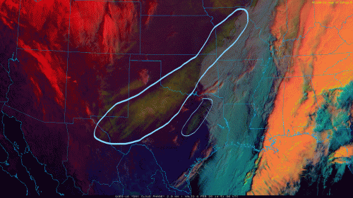
Good portion of Texas had a nice bout of wintry weather the last couple of days. Looks like one of the higher totals came out near Midland where they picked up just a hair under 8" (7.9" recorded). That makes it their 4th-largest snowstorm on record (10.6" being the largest which was back in 2012). Areas that received a good bit of snow also dropped down into the single digits early this morning.

Out in Katy, thought I heard a few 'pellets' hitting my window, but didn't bother to get up and investigate any further. Doesn't surprise me though that a few locations in SETX reported some sleet early this morning. Surface temperatures were in the upper 30s with a warm nose just above the surface up to about 750mb. However the mid layer was a bit dryer, so with wet bulb cooling, it likely helped in some of the sleet mixing in with the rain.

Was happy to see Austin get in on some action last night as isolated area picked up about a quarter of an inch of the white stuff, otherwise much of it melted on impact.

Neat shot of the snow covered ground across the state from the Big Bend up through the Midwest. Also notice a small swath NE of Austin that extends up between Dallas and Tyler. That was some snow that fell last night/early this morning, a pleasant surprise for those rural folks. While the NAM and HRRR did become more bullish with snow in that general area, looks like they got a bit more than what models showed. These Mexico disturbances can sometimes throw in a surprise or two from time to time. Similar to what we saw up in College Station last year.
Day Cloud Ph
Day Cloud Ph
Blake
Boomer Sooner
User avatar
DoctorMu
Posts: 5669
Joined: Sun Jun 28, 2015 11:58 am
Location: College Station
Contact:

unome wrote: Thu Feb 06, 2020 5:07 am chilly, but the plants survived

https://preview.weather.gov/edd/resourc ... ined|1#%2F
Just wondering - are there greenhouses in Texas? :mrgreen:
User avatar
DoctorMu
Posts: 5669
Joined: Sun Jun 28, 2015 11:58 am
Location: College Station
Contact:

Belmer wrote: Thu Feb 06, 2020 9:34 am Good portion of Texas had a nice bout of wintry weather the last couple of days. Looks like one of the higher totals came out near Midland where they picked up just a hair under 8" (7.9" recorded). That makes it their 4th-largest snowstorm on record (10.6" being the largest which was back in 2012). Areas that received a good bit of snow also dropped down into the single digits early this morning.

Out in Katy, thought I heard a few 'pellets' hitting my window, but didn't bother to get up and investigate any further. Doesn't surprise me though that a few locations in SETX reported some sleet early this morning. Surface temperatures were in the upper 30s with a warm nose just above the surface up to about 750mb. However the mid layer was a bit dryer, so with wet bulb cooling, it likely helped in some of the sleet mixing in with the rain.

Was happy to see Austin get in on some action last night as isolated area picked up about a quarter of an inch of the white stuff, otherwise much of it melted on impact.

Neat shot of the snow covered ground across the state from the Big Bend up through the Midwest. Also notice a small swath NE of Austin that extends up between Dallas and Tyler. That was some snow that fell last night/early this morning, a pleasant surprise for those rural folks. While the NAM and HRRR did become more bullish with snow in that general area, looks like they got a bit more than what models showed. These Mexico disturbances can sometimes throw in a surprise or two from time to time. Similar to what we saw up in College Station last year.

snow.gif

We Just missed out but, some flakes and sleet mixed in from Hearne to Temple and NW. Good for Austin!
Cromagnum
Posts: 2616
Joined: Thu Feb 03, 2011 10:42 pm
Contact:

So was that the last big hurrah for the "season" or do we have something else a week or two out?
User avatar
Belmer
Global Moderator
Global Moderator
Posts: 744
Joined: Thu Jan 06, 2011 7:29 pm
Location: Dallas, TX
Contact:

Cromagnum wrote: Thu Feb 06, 2020 10:43 am So was that the last big hurrah for the "season" or do we have something else a week or two out?
Depends. If you'll be in west or north TX, sure, another wintry event or two is possible. For us locally here in SETX, wouldn't hold my breath. PNA does remain negative moving towards neutral by end of the month. EPO also likely to move more neutral/positive.

Brief cold spells like we had yesterday into today are possible for the next couple of weeks, but without any significant blocking, (-NAO) I personally don't see anything on the horizon to get too worked up about. NAO will likely remain + through the month.

Now with that said, Euro and GFS do have a cutoff low digging into the Baja region mid week next week. Euro doesn't quite dig as far as the GFS does, but those out in west TX might see mixed precip again, though not sold on if there will be enough cold air present.


Edit to add: Forecast to go along with my response -

Forecasts of Teleconnection Indices
Blake
Boomer Sooner
User avatar
tireman4
Global Moderator
Global Moderator
Posts: 4468
Joined: Wed Feb 03, 2010 9:24 pm
Location: Humble, Texas
Contact:

00
FXUS64 KHGX 061731
AFDHGX

Area Forecast Discussion
National Weather Service Houston/Galveston TX
1131 AM CST Thu Feb 6 2020

.AVIATION [18Z TAF Issuance]...

Upper level trough has moved east and allowing clouds to clear out
of the area. TAFs are basically a wind forecast at this point with
winds turning from NW/W today to calm overnight to SW tomorrow.
Next chance for low ceilings may not be until the weekend.

Overpeck

&&

.SHORT TERM [Today through Tonight]...

Clouds continue to clear out as the upper level trough moves east
today. Overall forecast looks on track with T/Td/Sky trends.
Overall fairly quiet weather conditions in the short term part of
the forecast.

&&

.PREV DISCUSSION /Issued 527 AM CST Thu Feb 6 2020/...

.SHORT TERM...
As of 3 AM, the shower activity has exited to our east leaving
behind cloudy skies and chilly temperatures. The mostly cloudy
skies will linger through the late morning to early afternoon
hours, but then rapid clearing is expected during the afternoon
from west to east as high pressure builds to our west. Breezy
northwesterly flow will continue through the afternoon with
sustained winds of 10 to 15 mph and gusts up to 20mph. The winds
will be strongest along the coast with lighter winds inland, but
still breezy. This cool northwesterly flow will mean temperatures
will struggle to get out of the low 50s this afternoon. Montgomery
County and areas to the north may not even get out of upper 40s.
Clearing skies tomorrow night will mean another chilly night is in
store with much of the region dipping back down in the the mid to
upper 30s, with some subfreezing temperatures possible up in
Houston County. Overall, Friday is looking like fantastic weather.
Increasing heights due to the building high pressure and a more
southwesterly flow on Friday will lead to temperatures rebounding
with high temperatures back into the upper 60s to low 70s.

Fowler


.LONG TERM...(Fri Night through Thursday)
Friday night will start out clear but clouds will return after
midnight as low level moisture begins to increase in response to a
tightening pressure gradient and developing low pressure over west
central Texas. The area of low pressure becomes elongated into a
weak surface trough on Saturday and PW values increase to around
an inch by afternoon. The combination of a the surface trough and
moisture should yield a few showers in the afternoon and
evening. Temperatures will remain near steady or slowly warm
Saturday night as moderate south winds bring warmer and
increasingly humid air to the region.

Sunday will be considerably warmer and 850 mb temperatures support
surface temperatures in the mid to upper 70s. Fcst soundings show
two distinct saturated layers with the sfc-700 mb layer saturated,
with very dry air between 700-500 mb and then saturated from
500-300 mb. PW values in crease to 1.45 inches in the afternoon
and weak capping near 700 mb begins to erode. Jet dynamics also
look favorable with a weakly splitting jet and SE TX lying in a
weak LFQ. Models are not generating much QPF but there looks like
enough ingredients in place for scattered showers and
thunderstorms so bumped PoPs up to 30-40 percent.

Models begin to diverge Sunday night and Monday with regard to how
quickly a cold front moves through SE TX and if/where the cold
front may stall. The GFS is more aggressive than ECMWF in pushing
the front into the coastal waters with isentropic upglide bringing
SE TX periods of light rain and colder temperatures. The ECMWF
stalls the front and brings periods of showers and storms with
temperatures remaining mild. Both models are similar with the
timing of bringing a strong upper level trough into Baja CA on
Monday and moving this feature east through Tuesday night. The
combination of the front and lift from the upper low/SW upper flow
should keep things unsettled through mid week so high PoPS seem
justified. As for temperatures, just split the difference for now
and will await some consensus to form. Another cold front will
cross SE TX Thursday night or Friday with another chance of
showers and storms with the fropa. 43


.MARINE...

Moderate to strong offshore flow will continue through this
afternoon in the wake of yesterday`s cold front. A small craft
advisory has been issued for all Bays and Gulf waters through 6 AM,
then the Bays transition to caution flags through 6pm this
evening while the Gulf waters remain in an advisory. These
highlights may need to be extended into tonight, especially for
the Gulf waters off of Galveston Bay, but the flow transitions to
a light southwesterly flow after midnight tonight ending the
hazards. High pressure builds in on Friday and will continue
through the weekend resulting in light onshore flow.

The moderate to strong offshore flow today will lead to low tides to
be much below normal (around -1.0 to -1.5 feet below Mean Low Level
Water (MLLW)). So, a Low Water Advisory has been issued for
Galveston Bay today. Around one foot below MLLW, areas of bare
ground begin to appear in the upper reaches of the ship channel.
Once we get to around two feet below MLLW, then bare ground begins
to appear around Morgan`s Point and Manchester. Low Tide at
Manchester is around 12:37pm today. Low water may again be an issue
for tomorrow.

Fowler

&&

.PRELIMINARY POINT TEMPS/POPS...

College Station (CLL) 34 67 44 70 54 / 0 0 0 20 10
Houston (IAH) 37 68 51 70 55 / 0 0 0 20 10
Galveston (GLS) 48 67 58 68 60 / 0 0 0 10 10

&&

.HGX WATCHES/WARNINGS/ADVISORIES...

TX...None.
GM...SMALL CRAFT SHOULD EXERCISE CAUTION until 6 PM CST this evening
for the following zones: Galveston Bay...Matagorda Bay.

Low Water Advisory until 9 PM CST this evening for the following
zones: Galveston Bay.

Small Craft Advisory until 6 PM CST this evening for the
following zones: Coastal waters from Freeport to Matagorda
Ship Channel TX out 20 NM...Coastal waters from High Island
to Freeport TX out 20 NM...Waters from Freeport to
Matagorda Ship Channel TX from 20 to 60 NM...Waters from
High Island to Freeport TX from 20 to 60 NM.


&&

$$

AVIATION...Overpeck
User avatar
jasons2k
Posts: 5381
Joined: Thu Feb 04, 2010 12:54 pm
Location: Imperial Oaks
Contact:

Just what I was afraid of. Clear skies and dry air means my forecast low is now 31. That’s a 4 degree drop in one package. These tend to bust on the warm side so I’m gonna have to cover everything tonight. UGH!!
Post Reply
  • Information
  • Who is online

    Users browsing this forum: Ahrefs [Bot] and 22 guests