January 2020: Unsettled WX Week Ahead
Having to run the AC all day in my house in January is a joke. If I dont, it hits 73-74 inside and 65% humidity which feels awful. Here's hoping winter 2020-2021 happens because this one ended in November.
- Katdaddy
- Global Moderator

- Posts: 2502
- Joined: Thu Feb 04, 2010 8:18 am
- Location: League City, Tx
- Contact:
All temperature records were broken across SE TX yesterday. Today will be another warm and humid day with some showers across SE TX. In addition, there is another Dense Fog Advisory in effect this morning. The weather is looking better for the Houston Marathon Sunday morning after the frontal passage Saturday with showers and thunderstorms.
Yeah, I've been saying that. Winter was over in Novemeber. As Bill Belichick wols say "We're on to 2020-21".
we had no winter this year. Models were useless all season. I guess we'll run into seasons like this from time to time. As much as a love a good cold winter, I'm ready to just jump into spring and forget this year. I just hope it doesnt mean we will boil this summer..
-
redneckweather
- Posts: 1022
- Joined: Mon Feb 08, 2010 7:29 pm
- Location: Montgomery, Texas
- Contact:
And the models keep pushing the cold back another week, then a other week, then another until it fades away. Same song different dance. Yes a pattern change is coming to allow a couple seasonal fronts down. I mean hell, its January. Nothing out of the ordinary.
I never believed the long-term models. It’s the same almost every year. Re-read the December thread. It was supposed to be an ice box come Mid-January. We can see how that’s playing out.redneckweather wrote: ↑Thu Jan 16, 2020 9:05 am And the models keep pushing the cold back another week, then a other week, then another until it fades away. Same song different dance. Yes a pattern change is coming to allow a couple seasonal fronts down. I mean hell, its January. Nothing out of the ordinary.
I do see a pattern change coming....it's called SUMMER...lol
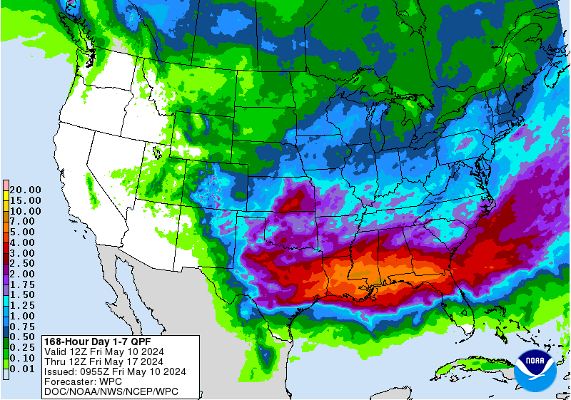
I think the big story regarding our weather for the next couple weeks will be above average rainfall. Hopefully that will pan out.
Ptarmigan wrote: ↑Wed Jan 15, 2020 9:26 pmAgreed. It is still winter. Winter is suppose to be cold.Kingwood36 wrote: ↑Wed Jan 15, 2020 7:58 pm If we dont have a decent shot at some cold air..screw the frozen stuff..can we move on to spring then? This is pathetic to be almost 80 degrees in the middle of January
The insects are going to be out of control in BCS unless we get a couple of weeks of cold weather with 4-8 freezes.
It's not just the maximums. Look at those minimums!Katdaddy wrote: ↑Thu Jan 16, 2020 5:35 am All temperature records were broken across SE TX yesterday. Today will be another warm and humid day with some showers across SE TX. In addition, there is another Dense Fog Advisory in effect this morning. The weather is looking better for the Houston Marathon Sunday morning after the frontal passage Saturday with showers and thunderstorms.
About the highest dewpoints I've ever seen in January, approaching 70°F. Yuck.
Insects love it...I'm sending them all Jason's way in the Spring.
- tireman4
- Global Moderator

- Posts: 4471
- Joined: Wed Feb 03, 2010 9:24 pm
- Location: Humble, Texas
- Contact:
000
FXUS64 KHGX 161741
AFDHGX
Area Forecast Discussion
National Weather Service Houston/Galveston TX
1141 AM CST Thu Jan 16 2020
.AVIATION...
LIFR/IFR conditions are very slowly improving and should be moving
into MVFR territory (except at the coast) in the next few hours.
A decaying, weak frontal boundary will be sagging into northern
parts of the area this afternoon and evening. Expect some sct
areas of shra/-ra as it does so...but overall confidence as to
where and when is low so went with just some VCSH`s as a first
guess and will amend as necessary. Ceilings will again lower this
evening and remain in the 500-1500ft range into late morning
Friday. Areas of dense sea fog will remain an issue near the
coast. 47
.DISCUSSION...
Visibilities are all above advsy criteria inland so will allow the
remaining products to expire at noon there...but continue them offshore
where it`ll linger thru the day. Look for it to gradually begin
returning inland around or shortly before sunset. 47
&&
.PRELIMINARY POINT TEMPS/POPS...
College Station (CLL) 74 59 73 59 69 / 30 30 30 40 40
Houston (IAH) 74 62 72 62 73 / 30 20 20 30 60
Galveston (GLS) 70 63 70 64 72 / 20 20 20 30 60
&&
.HGX WATCHES/WARNINGS/ADVISORIES...
TX...Dense Fog Advisory until noon CST today for the following zones:
Brazoria Islands...Galveston Island and Bolivar Peninsula...
Matagorda Islands.
GM...Dense Fog Advisory until noon CST today for the following zones:
Galveston Bay...Matagorda Bay.
Dense Fog Advisory until 2 PM CST this afternoon for the
following zones: Coastal waters from Freeport to Matagorda
Ship Channel TX out 20 NM.
Dense Fog Advisory until 10 PM CST this evening for the
following zones: Coastal waters from High Island to
Freeport TX out 20 NM.
&&
$$
- Katdaddy
- Global Moderator

- Posts: 2502
- Joined: Thu Feb 04, 2010 8:18 am
- Location: League City, Tx
- Contact:
A little cooler this morning across SE TX with less fog. Another day of clouds, a few showers, and highs in the 70s. A cold front will move across SE TX tomorrow with rain and a few thunderstorms with clearing skies Saturday night resulting in nice weather Sunday for the Houston Marathon.
For the last three days, the NWS has had me at 34 on Monday night. Pretty consistent.
This looks promising:


Promising to be wet at any rate.
- tireman4
- Global Moderator

- Posts: 4471
- Joined: Wed Feb 03, 2010 9:24 pm
- Location: Humble, Texas
- Contact:
524
FXUS64 KHGX 171737
AFDHGX
Area Forecast Discussion
National Weather Service Houston/Galveston TX
1137 AM CST Fri Jan 17 2020
.AVIATION...
IFR ceilings/visibilities will slowly lift in the next 3 hours as
the diffuse backdoor frontal boundary washes out and a southeast
flow resumes. Conditions again deteriorate overnight as sea fog
rolls in and low stratus redevelops well inland. Expect a
combination of LIFR/IFR conditions as we head into the late
evening hours. Tail end of an upper disturbance passes across
northern terminal sites toward midnight which may bring a few
showers but should cause any additional impacts. Expect a broken
band of showers (and possibly an embedded tstm closer to the
coast) to develop ahead of a prefrontal trof as it pushes into the
region early Sat morning. Precip should taper off as the front
itself pushes thru. Current penciled in timing for that: CLL 16z,
IAH 20z, GLS 23z. 47
&&
.PRELIMINARY POINT TEMPS/POPS...
College Station (CLL) 72 61 65 39 55 / 20 50 60 10 0
Houston (IAH) 72 63 74 45 56 / 40 20 50 20 10
Galveston (GLS) 70 63 72 51 57 / 30 20 50 30 10
&&
.HGX WATCHES/WARNINGS/ADVISORIES...
TX...NONE.
GM...NONE.
&&
$$
I noticed today that the red maples are starting to bloom already.
Back to seasonal. No major freezes ahead. Save the rain for the Spring and Summer!
The front definitely cooled things off but this isn't bad at all for mid-January. Once the wind dies down it will be very nice.
-
- Information
-
Who is online
Users browsing this forum: Ahrefs [Bot], Bing [Bot], Semrush [Bot] and 76 guests