Page 1 of 76
September 2019 - Warm End of September
Posted: Thu Aug 22, 2019 3:51 pm
by BlueJay
Tropical activity? Early fall activity? We will see. Stay tuned...
Re: September 2019 - Labor Day Weekend/Tracking The Tropics
Posted: Mon Aug 26, 2019 8:26 am
by srainhoutx
Will post Monday weather briefing from Jeff in the September Topic since he's looking ahead to Labor Day Weekend...
Dorian becoming better organized
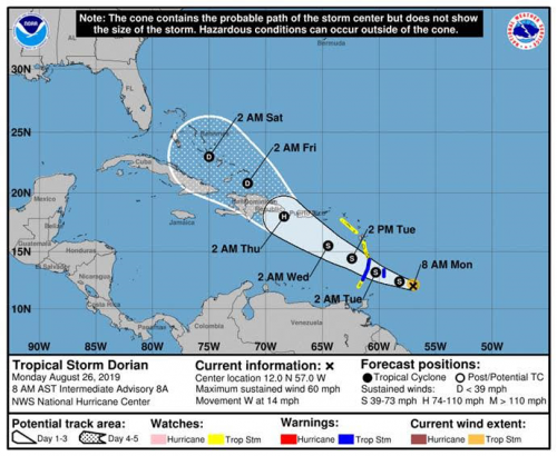
Tropical Storm Watches and Warnings are now in effect for much of the Windward Islands.
Discussion:
While Dorian remains small and compact, recent satellite images show a decent increase in the convective pattern of the tropical cyclone with explosions of deep convection near and over the center. NHC has increased the intensity to 60mph with an estimated central pressure of 1002mb. Additionally, Dorian has featured the development of some ragged banding features this morning and the overall look of the system is improving.
Track:
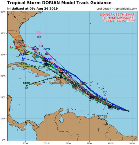
Dorian is located 205 miles ESE of Barbados and is moving toward the west at 14mph. This westward motion will continue today with a gradual turn toward the WNW as the system moves through the Windwards Islands tonight and Tuesday. Once in the eastern Caribbean Sea, Dorian will begin to turn toward the NW under the increasing influence of a large upper level trough over the southern Bahamas and Cuba which will cause a weakness in the sub-tropical ridge of high pressure north of the storm. On this track, Dorian will be approaching the eastern portions of the Dominican Republic Thursday and how the system interacts with the tall mountainous terrain of that island will be key to the eventual outcome for the system. Toward the end of the period high pressure does begin to build back westward north of Dorian, so if the system survives the Dominican Republic a continued WNW track into the Bahamas looks most likely.
It should be noted that the track guidance through 5 days continues to be in very good agreement with little variation in models nor model cycles which yields a fairly high confidence track forecast.
Intensity:
Unlike the track forecast, the intensity forecast is much more problematic as there continues to be significant spread in the intensity guidance and the overall small nature of Dorian makes it extremely vulnerable to surrounding atmospheric challenges such as wind shear, dry air, and land interaction. Thus far, the system appears to have been able to fight off the dry air intrusions as noted on the evening Barbados sounding yesterday and the high altitude mission dropsondes that was flown both showing significant mid level dry air especially to the west of the system. Such dry air when entrained into the system results in the collapse of the deep convection and without sustained convection the surface circulation has a hard time maintaining itself. Wind shear is forecast to remain light over the next 24-48 hours, but then increase as the system reaches the NE Caribbean Sea toward the middle to end of the week. Several of the global forecast models weaken Dorian to a weak TS or even open wave over the eastern Caribbean Sea and this is certainly possible while other models make Dorian a hurricane. Dorian is the type of system that could see large swings in intensity in a short period of time. NHC continues to indicate Dorian becoming a hurricane briefly over the eastern Caribbean Sea and then significant weakening as the small system interacts with the mountains of the Dominican Republic.


Gulf (Late week/weekend):
Global models indicate that a tropical wave or disturbance will move into the eastern Gulf of Mexico late this week and then slowly move westward over the Labor Day weekend. This feature would be located south of a frontal system along the US Gulf coast and south of building high pressure over the SE US and mid Atlantic. None of the global models show any significant strengthening with this system but do attempt to close off a weak surface low over the central and western Gulf of Mexico this weekend into early next week with little motion. Something to keep an eye on since it is late August and things can quickly change this time of year.
Re: September 2019 - Labor Day Weekend/Tracking The Tropics
Posted: Mon Aug 26, 2019 4:30 pm
by jasons2k
Another Lucy, perhaps?
Re: September 2019 - Labor Day Weekend/Tracking The Tropics
Posted: Mon Aug 26, 2019 6:30 pm
by Cpv17
Looks like the tropics are about to get pretty active:

Re: September 2019 - Labor Day Weekend/Tracking The Tropics
Posted: Mon Aug 26, 2019 10:13 pm
by Ptarmigan
Spetember is going to heat up for sure.
Re: September 2019 - Labor Day Weekend/Tracking The Tropics
Posted: Mon Aug 26, 2019 10:23 pm
by Texaspirate11
Cpv17 wrote: ↑Mon Aug 26, 2019 6:30 pm
Looks like the tropics are about to get pretty active:

Where did you get this? Would love to capture this map
Re: September 2019 - Labor Day Weekend/Tracking The Tropics
Posted: Mon Aug 26, 2019 11:28 pm
by Cpv17
Texaspirate11 wrote: ↑Mon Aug 26, 2019 10:23 pm
Cpv17 wrote: ↑Mon Aug 26, 2019 6:30 pm
Looks like the tropics are about to get pretty active:

Where did you get this? Would love to capture this map
Found it on Storm2k under the Talking Tropics thread.
Re: September 2019 - Labor Day Weekend/Tracking The Tropics
Posted: Mon Aug 26, 2019 11:37 pm
by Scott747
0z GFS run is good times. It has the ghost of 90l in the central gulf and Dorian hitting a wall and goes due w across fla exiting n of tampa.
Re: September 2019 - Labor Day Weekend/Tracking The Tropics
Posted: Mon Aug 26, 2019 11:44 pm
by Cpv17
Scott747 wrote: ↑Mon Aug 26, 2019 11:37 pm
0z GFS run is good times. It has the ghost of 90l in the central gulf and Dorian hitting a wall and goes due w across fla exiting n of tampa.
I think it’ll go more towards south Florida around Miami and then bend back west with that strong ridge building in. After that, who knows.
Re: September 2019 - Labor Day Weekend/Tracking The Tropics
Posted: Tue Aug 27, 2019 4:46 am
by Scott747
Both the overnight ensembles continued to shift w, especially the euro. However the operational is still further up n through Florida before turning more towards the nw.
NHC guidance shows a slight bend to the left at the longer range. Key will be how much the weakness to the n is before the ridge builds back in.
I think the threat for the ngom (after any fla impact) has went up slightly. If the trend towards the w continues then it will be time to assess any potential threat here. That's even if Dorian survives trek out of the Caribbean.
More often than not these trends switch around so I wouldn't be surprised to see a shift back to the e today.
Re: September 2019 - Labor Day Weekend/Tracking The Tropics
Posted: Tue Aug 27, 2019 9:13 am
by srainhoutx
The morning surface charts issued by the Weather Prediction Center suggest a wave of weak low pressure moving West across the Gulf and possibly TS Dorian near Florida and entering the NE Gulf on Labor Day.
Re: September 2019 - Labor Day Weekend/Tracking The Tropics
Posted: Tue Aug 27, 2019 11:48 am
by Kingwood36
Icon takes it right into south florida and into the gom.
https://www.tropicaltidbits.com/analysi ... 712&fh=168
Re: September 2019 - Labor Day Weekend/Tracking The Tropics
Posted: Tue Aug 27, 2019 2:55 pm
by Scott747
Big shift to the w on the 0z euro. Looking downstream I don't see how it could get this far w with what looks like a weak front but the ngom could be in play after a fla impact.
Re: September 2019 - Labor Day Weekend/Tracking The Tropics
Posted: Tue Aug 27, 2019 3:55 pm
by sau27
Well, looks like we can trash the 12Z Euro and GFS ensembles. Neither correctly initialized with Dorian's new reformed center. Lets do it again in a few hours.
Re: September 2019 - Labor Day Weekend/Tracking The Tropics
Posted: Tue Aug 27, 2019 5:12 pm
by Scott747
sau27 wrote: ↑Tue Aug 27, 2019 3:55 pm
Well, looks like we can trash the 12Z Euro and GFS ensembles. Neither correctly initialized with Dorian's new reformed center. Lets do it again in a few hours.
The data from the upper level NOAA mission should be ingested in the 0z suite tonight and may help bring some clarity.
T
Re: September 2019 - Labor Day Weekend/Tracking The Tropics
Posted: Tue Aug 27, 2019 5:33 pm
by sau27
Scott747 wrote: ↑Tue Aug 27, 2019 5:12 pm
sau27 wrote: ↑Tue Aug 27, 2019 3:55 pm
Well, looks like we can trash the 12Z Euro and GFS ensembles. Neither correctly initialized with Dorian's new reformed center. Lets do it again in a few hours.
The data from the upper level NOAA mission should be ingested in the 0z suite tonight and may help bring some clarity.
T
Any idea if 18z GFS is initializing off of correct center fix? It definitely does not seem to think much of the west Atlantic ridge. This is the strongest and furthest east run so far.
Re: September 2019 - Labor Day Weekend/Tracking The Tropics
Posted: Tue Aug 27, 2019 5:46 pm
by Scott747
sau27 wrote: ↑Tue Aug 27, 2019 5:33 pm
Scott747 wrote: ↑Tue Aug 27, 2019 5:12 pm
sau27 wrote: ↑Tue Aug 27, 2019 3:55 pm
Well, looks like we can trash the 12Z Euro and GFS ensembles. Neither correctly initialized with Dorian's new reformed center. Lets do it again in a few hours.
The data from the upper level NOAA mission should be ingested in the 0z suite tonight and may help bring some clarity.
T
Any idea if 18z GFS is initializing off of correct center fix? It definitely does not seem to think much of the west Atlantic ridge. This is the strongest and furthest east run so far.
Initialization looked ok on both. New GFS is just way faster allowing it further n along with a weaker ridge.
The modeling is just way out of whack right now. The big 3 are all over the place. Ukie s fla, Euro c fla and now the GFS ga/sc.
Re: September 2019 - Labor Day Weekend/Tracking The Tropics
Posted: Tue Aug 27, 2019 7:25 pm
by Texaspirate11
Lots of Sal coming off of Africa now. That wont affected Dorian but he still needs to meet some rough terrain
Re: September 2019 - Labor Day Weekend/Tracking The Tropics
Posted: Tue Aug 27, 2019 7:42 pm
by sau27
Really rubs me the wrong way to see a certain TV met showing the 18z Gfs as if it’s solution is a done deal for this storm during their weather segment tonight. If anything that run was an outlier at this point.
Re: September 2019 - Labor Day Weekend/Tracking The Tropics
Posted: Tue Aug 27, 2019 9:16 pm
by Texaspirate11
Who is it???
