September 2019 - Warm End of September

General Weather Discussions and Analysis
jabcwb2
Posts: 180
Joined: Thu Feb 04, 2010 5:43 am
Location: Tomball, Texas
Contact:

Lurker here.....so Cypress, Spring and Kingwood are not going to get the heavy rains over the next couple of days? Just enough to make the yards happy?!?!?!?!?! Thanks for your fastidiousness to the weather!!!!!!!!!!!!!!!!!! :D

The reason I asked is because we close on our first home Thursday.....Moving from Cypress/Tomball line to Kingwood.

Any info would be great! Thanks so much.
Last edited by jabcwb2 on Tue Sep 17, 2019 12:52 pm, edited 1 time in total.
User avatar
srainhoutx
Site Admin
Site Admin
Posts: 19616
Joined: Tue Feb 02, 2010 2:32 pm
Location: Maggie Valley, NC
Contact:

TD 11 Update from Jeff:

Tropical depression forms just off the TX coast

Tropical Storm Warnings are issued from Sargent TX to Port Bolivar TX

Depression is located 15 miles SSW of Freeport TX moving to the N at 7mph.

The depression will make landfall over eastern Brazoria County and western Galveston County this afternoon.

Attachments
1568739795986_image001.png
Carla/Alicia/Jerry(In The Eye)/Michelle/Charley/Ivan/Dennis/Katrina/Rita/Wilma/Humberto/Ike/Harvey

Member: National Weather Association
Facebook.com/Weather Infinity
Twitter @WeatherInfinity
User avatar
djmike
Posts: 1703
Joined: Fri Jan 07, 2011 12:19 pm
Location: BEAUMONT, TX
Contact:

tireman4 wrote: Tue Sep 17, 2019 12:28 pm 5000 Cape To The East of TD 11
What does that mean?
Mike
Beaumont, TX
(IH-10 & College Street)
User avatar
tireman4
Global Moderator
Global Moderator
Posts: 4480
Joined: Wed Feb 03, 2010 9:24 pm
Location: Humble, Texas
Contact:

djmike wrote: Tue Sep 17, 2019 12:33 pm
tireman4 wrote: Tue Sep 17, 2019 12:28 pm 5000 Cape To The East of TD 11
What does that mean?
Well, I am just a historian and librarian ( I will let the pros handle this) but that is a rich environment for rapid intensification..especially out in the Gulf...
User avatar
tireman4
Global Moderator
Global Moderator
Posts: 4480
Joined: Wed Feb 03, 2010 9:24 pm
Location: Humble, Texas
Contact:

CAPE is a term you’ll hear a lot especially in severe weather season. CAPE stands for Convective Available Potential Energy and is a way of quantifying how much energy there is available in the atmosphere for thunderstorms to develop and strengthen. Thunderstorms are fueled by the buoyancy of air parcels in the atmosphere. An air parcel is a basketball sized parcel of air whose properties can be analyzed and tracked. Air parcels can have properties that can be either similar or different than their environment (the rest of the atmosphere at a given location) depending on the situation. The properties we care about most when trying to determine CAPE are temperature and dew point. Be sure to see my article explaining the dew point if you’re unfamiliar with that concept.
Texashawk
Posts: 170
Joined: Wed Feb 02, 2011 1:29 pm
Contact:

So they do now think we will have a TS., right?
Cpv17
Posts: 5296
Joined: Fri Aug 31, 2018 1:58 pm
Location: El Campo/Wharton
Contact:

djmike wrote: Tue Sep 17, 2019 12:33 pm
tireman4 wrote: Tue Sep 17, 2019 12:28 pm 5000 Cape To The East of TD 11
What does that mean?
A very unstable airmass with plenty of energy for significant storms.
User avatar
djmike
Posts: 1703
Joined: Fri Jan 07, 2011 12:19 pm
Location: BEAUMONT, TX
Contact:

Thanks guys for the explanation
Mike
Beaumont, TX
(IH-10 & College Street)
jabcwb2
Posts: 180
Joined: Thu Feb 04, 2010 5:43 am
Location: Tomball, Texas
Contact:

Lurker here.....so Cypress, Spring and Kingwood are not going to get the heavy rains over the next couple of days? Just enough to make the yards happy?!?!?!?!?! Thanks for your fastidiousness to the weather!!!!!!!!!!!!!!!!!! :D

The reason I asked is because we close on our first home Thursday.....Moving from Cypress/Tomball line to Kingwood.

Any info would be great! Thanks so much.
User avatar
jasons2k
Posts: 5397
Joined: Thu Feb 04, 2010 12:54 pm
Location: Imperial Oaks
Contact:

If the NHC track verifies (and I would bet on them) then the Houston area will indeed be at risk for a core event, similar to what yesterday’s models were showing after all....and I will retract my comments from this morning.
TexasBreeze
Posts: 942
Joined: Sun Sep 26, 2010 4:46 pm
Location: NW Houston, TX
Contact:

All of Harris County is still under the threat of heavy rains and flooding. It looks to track right over the county and doing so at night and early morning is concerning...
Also don't forget about feeder banding setting up during daytime heating if it continues north then takes a more north westerly jog as NHC indicates.
User avatar
DoctorMu
Posts: 5691
Joined: Sun Jun 28, 2015 11:58 am
Location: College Station
Contact:

jasons wrote: Tue Sep 17, 2019 10:55 am
srainhoutx wrote: Tue Sep 17, 2019 10:51 am 
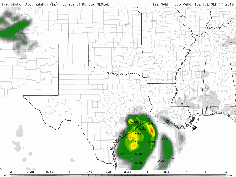
If you are looking at the various 12Z Mesoscale models, an eyebrow is raised with the very slow meandering surface low pressure that just seems to want to creep ever so slowly inland. There remains a lot of uncertainty regarding where (which locations/neighborhoods), how much rain will fall and just how long this will continue over the next 60 hours or so.
The big question is where does it come-in and then drift? Center seems to be east of all the models. That could make a HUGE difference, especially for folks like Cpv17 and Dr. Mu...
The storm has an elongated center. If I had to pick a very center, below Bay City now.

Still, we may get very little up here while the NE quadrant from Houston to Beaumont could be dealing with a foot+ of precip.
User avatar
jasons2k
Posts: 5397
Joined: Thu Feb 04, 2010 12:54 pm
Location: Imperial Oaks
Contact:

It will come down to tens of miles with this one....
User avatar
srainhoutx
Site Admin
Site Admin
Posts: 19616
Joined: Tue Feb 02, 2010 2:32 pm
Location: Maggie Valley, NC
Contact:

Key messages from West Gulf River Forecast Center...
Attachments
EErvu60U4AAto5X.jpg
Carla/Alicia/Jerry(In The Eye)/Michelle/Charley/Ivan/Dennis/Katrina/Rita/Wilma/Humberto/Ike/Harvey

Member: National Weather Association
Facebook.com/Weather Infinity
Twitter @WeatherInfinity
User avatar
Rip76
Posts: 1788
Joined: Mon Feb 15, 2010 12:38 am
Location: The Woodlands
Contact:

Tropical Storm Imelda
Texashawk
Posts: 170
Joined: Wed Feb 02, 2011 1:29 pm
Contact:

Well, that escalated quickly... wasn’t this 20% to develop into a depression just last night?
Cromagnum
Posts: 2622
Joined: Thu Feb 03, 2011 10:42 pm
Contact:

Just got a Tropical Storm warning on my phone.
ccbluewater
Posts: 64
Joined: Tue May 23, 2017 1:16 pm
Location: Cypress
Contact:

Why not just upgrade straight to T.S.? Regardless, impacts are the same.
Cpv17
Posts: 5296
Joined: Fri Aug 31, 2018 1:58 pm
Location: El Campo/Wharton
Contact:

Texashawk wrote: Tue Sep 17, 2019 1:19 pm Well, that escalated quickly... wasn’t this 20% to develop into a depression just last night?
It was 10% for the longest time.
Post Reply
  • Information