
August 2019: Weak Cold Front/Rain Chances To End August

I’ll take a weak rainmaker, with some wind.

-
Katdaddy

- Global Moderator

- Posts: 2502
- Joined: Thu Feb 04, 2010 8:18 am
- Location: League City, Tx
- Contact:
Expect another hot day with scattered afternoon showers and thunderstorms. This pattern will continue through the weekend for SE TX. A few showers and thunderstorms ongoing across SE TX this morning.
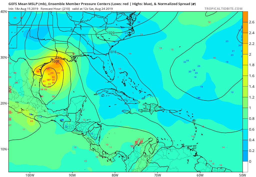
Time to watch the tropics next week. From this morning’s Houston-Galveston AFD:
Late week weather will be highly dependent on whatever evolves out of the Bay of Campeche. As of now, confidence is highest on a northern-moving weak broad closed-off low or an open wave moving into a lower height channel positioned over Texas. A few GEFS ensemble members do place closed-off surface circulations off the Texas coastline by Day 10. This feature is currently progged by both the GFS and ECMWF to skirt up the Texas coastline and be a rain maker for the western Gulf and many Texas coastal communities Friday through possibly Sunday. While on the extended cusp of this forecast package, this scenario will certainly garner much attention from us as we head into early next week.
- Attachments
-
- Screen Shot 2019-08-16 at 5.38.06 AM.png (112.02 KiB) Viewed 3595 times
-
Andrew
- Site Admin

- Posts: 3440
- Joined: Wed Feb 03, 2010 9:46 pm
- Location: North-West Houston
- Contact:
Don't pay too much attention to the operational models right now they will make pretty wild swings. What is more interesting to me is the support the GFS ensembles are showing. Most of the ensembles show some sort of development over the next week/week & a half. ECMWF ensembles are less aggressive so I would like to see more support here before fully jumping on the development ship. The other thing to keep an eye on is how much development occurs in the Pacific because it's hard to get multiple systems so close to each other. Either way, something to watch going into next week.
For Your Infinite Source For All Things Weather Visit Our Facebook

When I went to bed last night, today’s forecast was “mostly sunny” and no mention of rain.
Now there is a 30% chance. So there is hope. There were even a few early morning storms in the area which is always a good sign for a tropical-like day.
Now there is a 30% chance. So there is hope. There were even a few early morning storms in the area which is always a good sign for a tropical-like day.

Im now flooded in 
Flood Advisory
Flood Advisory
National Weather Service Lake Charles LA
848 AM CDT Fri Aug 16 2019
TXC245-161445-
/O.NEW.KLCH.FA.Y.0065.190816T1348Z-190816T1445Z/
/00000.N.ER.000000T0000Z.000000T0000Z.000000T0000Z.OO/
Jefferson TX-
848 AM CDT Fri Aug 16 2019
The National Weather Service in Lake Charles has issued a
* Urban and Small Stream Flood Advisory for...
Northern Jefferson County in southeastern Texas...
* Until 945 AM CDT.
* At 847 AM CDT, Doppler radar indicated heavy rain due to
thunderstorms. This will cause urban and small stream flooding in
the advisory area. Up to one inch of rain has already fallen.
* Some locations that will experience flooding include...
Beaumont, Port Arthur, Nederland, Central Gardens, Bevil Oaks,
China, Fannett, La Belle, Port Acres and Southeast Texas Regional
Airport.
Additional rainfall of one to two inches is expected over the area.
This additional rain will result in minor flooding.
PRECAUTIONARY/PREPAREDNESS ACTIONS...
Turn around, don`t drown when encountering flooded roads. Most flood
deaths occur in vehicles.
&&
LAT...LON 3011 9438 3010 9436 3012 9430 3014 9428
3016 9428 3017 9422 3019 9421 3019 9418
3017 9417 3017 9412 3014 9411 3013 9408
3011 9407 3008 9409 3008 9405 2994 9397
2986 9408 2985 9422 2997 9429 3010 9440
$$
Rua
Flood Advisory
Flood Advisory
National Weather Service Lake Charles LA
848 AM CDT Fri Aug 16 2019
TXC245-161445-
/O.NEW.KLCH.FA.Y.0065.190816T1348Z-190816T1445Z/
/00000.N.ER.000000T0000Z.000000T0000Z.000000T0000Z.OO/
Jefferson TX-
848 AM CDT Fri Aug 16 2019
The National Weather Service in Lake Charles has issued a
* Urban and Small Stream Flood Advisory for...
Northern Jefferson County in southeastern Texas...
* Until 945 AM CDT.
* At 847 AM CDT, Doppler radar indicated heavy rain due to
thunderstorms. This will cause urban and small stream flooding in
the advisory area. Up to one inch of rain has already fallen.
* Some locations that will experience flooding include...
Beaumont, Port Arthur, Nederland, Central Gardens, Bevil Oaks,
China, Fannett, La Belle, Port Acres and Southeast Texas Regional
Airport.
Additional rainfall of one to two inches is expected over the area.
This additional rain will result in minor flooding.
PRECAUTIONARY/PREPAREDNESS ACTIONS...
Turn around, don`t drown when encountering flooded roads. Most flood
deaths occur in vehicles.
&&
LAT...LON 3011 9438 3010 9436 3012 9430 3014 9428
3016 9428 3017 9422 3019 9421 3019 9418
3017 9417 3017 9412 3014 9411 3013 9408
3011 9407 3008 9409 3008 9405 2994 9397
2986 9408 2985 9422 2997 9429 3010 9440
$$
Rua
Mike
Beaumont, TX
(IH-10 & College Street)
Beaumont, TX
(IH-10 & College Street)
Now that I just finished watering the lawn and soaking the trees and shrubs, today will be the day I get dumped on.
we had an automated call from CenterPoint yesterday, after 6:30 asking us to reduce usage from 3-7 PM. This was apparently the 2nd time in 3 days, never had any notice the 1st time. There has to be a better way to alert people ?
https://twitter.com/ercot_iso
https://twitter.com/ercot_iso
-
srainhoutx

- Site Admin
- Posts: 19615
- Joined: Tue Feb 02, 2010 2:32 pm
- Location: Maggie Valley, NC
- Contact:
NWSWGRFCVerified account @NWSWGRFC · 15m15 minutes ago
Just a friendly reminder...it ain't over til it's over. The Atlantic Hurricane Season runs through Nov 30. The August update...still expecting activity to ramp up. The "normal" peak for tropical activity is Sep 10. Now is a good time to review your plans and be prepared.
Just a friendly reminder...it ain't over til it's over. The Atlantic Hurricane Season runs through Nov 30. The August update...still expecting activity to ramp up. The "normal" peak for tropical activity is Sep 10. Now is a good time to review your plans and be prepared.
- Attachments
-
Carla/Alicia/Jerry(In The Eye)/Michelle/Charley/Ivan/Dennis/Katrina/Rita/Wilma/Humberto/Ike/Harvey
Member: National Weather Association
Facebook.com/Weather Infinity
Twitter @WeatherInfinity
Member: National Weather Association
Facebook.com/Weather Infinity
Twitter @WeatherInfinity
Models have pretty much dropped development today. Now it just looks like an increase in moisture in about a week from now, but I wouldn’t write this off yet.
-
srainhoutx
- Site Admin
- Posts: 19615
- Joined: Tue Feb 02, 2010 2:32 pm
- Location: Maggie Valley, NC
- Contact:
Friday afternoon weather briefing from Jeff:
More typical summer weather in store for the region through the weekend into early next week with daily chances for afternoon showers and thunderstorms.
Air mass is tropical and unstable across the area early this afternoon with seabreeze showers and thunderstorms having worked their way from the beaches up toward the US 59 corridor and will continue to spread inland over the next several hours. Those lucky enough to get under one of these storms will likely see a quick inch or better of rainfall while others only a few miles away could be left completely dry. Similar pattern will be in place through the weekend into early next week with a general weakness over coast TX and the “heat ridge” of earlier this week having positioned itself back over the SW US. Since grounds have dried out recently, afternoon temperatures are still reaching the upper 90’s even though the subsidence of the ridge has backed off to the west. With that in mind, and the scattered nature of the expected rains, will continue with mid to upper 90’s each afternoon and lows in the upper 70’s to low 80’s with a 30-40% chance of daily storms moving inland from the coast.
Next Week:
Weakness aloft will continue so expect an continued daily chance of showers and thunderstorms along the seabreeze boundary with little change in temperatures. Tropical wave near 55W will move through the Caribbean Sea and toward the Yucatan and potentially the Gulf of Mexico by the middle to end of next week. Various solutions are at play with this feature, so for now will just continue with a chance of afternoon thunderstorms and see if any of the moisture with this wave gets brought up toward the TX coast.
Fire Weather:
Dry and hot conditions of late has continued to dry soil moisture and fine fuels. Wildfire activity has been generally increasing across the area…mainly north and west of the metro region. Overall fire conditions are not overly favorable for fire growth with generally light winds and decent humidity and very good overnight recovery. Lightning from thunderstorms could result in isolated fire starts over the region. KBD values range from 400-700 over the region with large variations over short distances due to the convective nature of the rainfall on Wednesday and Thursday. The current average value for Harris County is 588.
The following counties have enacted countywide burn bans in SE TX:
Madison, Brazos, Walker, Grimes, Waller, Fort Bend, Galveston, Wharton, Colorado, and Jackson.
Carla/Alicia/Jerry(In The Eye)/Michelle/Charley/Ivan/Dennis/Katrina/Rita/Wilma/Humberto/Ike/Harvey
Member: National Weather Association
Facebook.com/Weather Infinity
Twitter @WeatherInfinity
Member: National Weather Association
Facebook.com/Weather Infinity
Twitter @WeatherInfinity
Right in-between two developing cells - fingers crossed!!
Right on the very edge!!
Right on the very edge!!
-
srainhoutx
- Site Admin
- Posts: 19615
- Joined: Tue Feb 02, 2010 2:32 pm
- Location: Maggie Valley, NC
- Contact:
The afternoon Climate Prediction Center Day 6 to 10 and Day 8 to 14 Precipitation Outlooks look a bit more promising regarding rain chances, but could come with a price. There is some chance that tropical moisture/mischief could come into play. We will continue to monitor.
- Attachments
-
-
-
Carla/Alicia/Jerry(In The Eye)/Michelle/Charley/Ivan/Dennis/Katrina/Rita/Wilma/Humberto/Ike/Harvey
Member: National Weather Association
Facebook.com/Weather Infinity
Twitter @WeatherInfinity
Member: National Weather Association
Facebook.com/Weather Infinity
Twitter @WeatherInfinity
Looking at the Euro, it looks like it’s targeting southwest LA right now.srainhoutx wrote: ↑Fri Aug 16, 2019 7:27 pm The afternoon Climate Prediction Center Day 6 to 10 and Day 8 to 14 Precipitation Outlooks look a bit more promising regarding rain chances, but could come with a price. There is some chance that tropical moisture/mischief could come into play. We will continue to monitor.
I got nothing today. We need some rain. The grass in non -irrigated areas, like road medians, is starting to dry out and die off. Each day is a big difference..
I actually need a break from the rain so I can mow.
We’ll know more in 3 or 4 days from now, but as of right now it doesn’t even really look like we’ll get any rain from this tropical wave in the western half of the viewing area.

-
MontgomeryCoWx

- Posts: 2356
- Joined: Wed Dec 14, 2011 4:31 pm
- Location: Weimar, TX
- Contact:
7 days until College Football starts!
Gators vs Canes next saturday
Climatological Fall is in 15 days.... give me some cold fronts. Summer sucks!
Gators vs Canes next saturday
Climatological Fall is in 15 days.... give me some cold fronts. Summer sucks!
Team #NeverSummer
We got some rain here in Stafford yesterday evening. Had a very brief shower this morning. Fingers crossed for later this afternoon!