
This is the part I read referring to that storm (Rain and thunderstorms will be the predicament this time around from TX and OK through the Deep South).......looks like normal rain and TS for Se Tx...Unless I read it wrong.Portastorm wrote:Didn't see anyone post this yet so I thought I would ... link below to Larry Cosgrove's latest blog entry. He's basically saying look for a major Arctic outbreak in the next 10 days which could set some new record lows in Texas. He's also bullish on one more winter storm. After about Feb. 25th though ... seems like he's suggesting the pattern relaxes and winter may be over (or at least return to normal climatological values).
The link:
http://www.examiner.com/x-3775-Houston- ... -600-PM-CT
February Weather Discussion. Wild Winter Storms?

Portastorm wrote:Didn't see anyone post this yet so I thought I would ... link below to Larry Cosgrove's latest blog entry. He's basically saying look for a major Arctic outbreak in the next 10 days which could set some new record lows in Texas. He's also bullish on one more winter storm. After about Feb. 25th though ... seems like he's suggesting the pattern relaxes and winter may be over (or at least return to normal climatological values).
The link:
http://www.examiner.com/x-3775-Houston- ... -600-PM-CT
-
srainhoutx

- Site Admin

- Posts: 19615
- Joined: Tue Feb 02, 2010 2:32 pm
- Location: Maggie Valley, NC
- Contact:
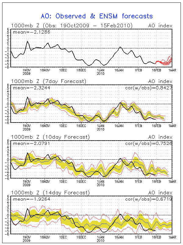
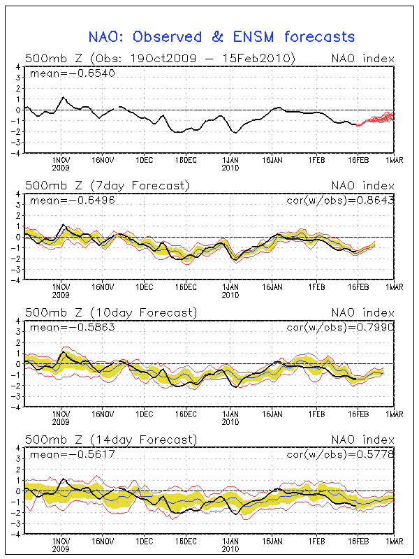
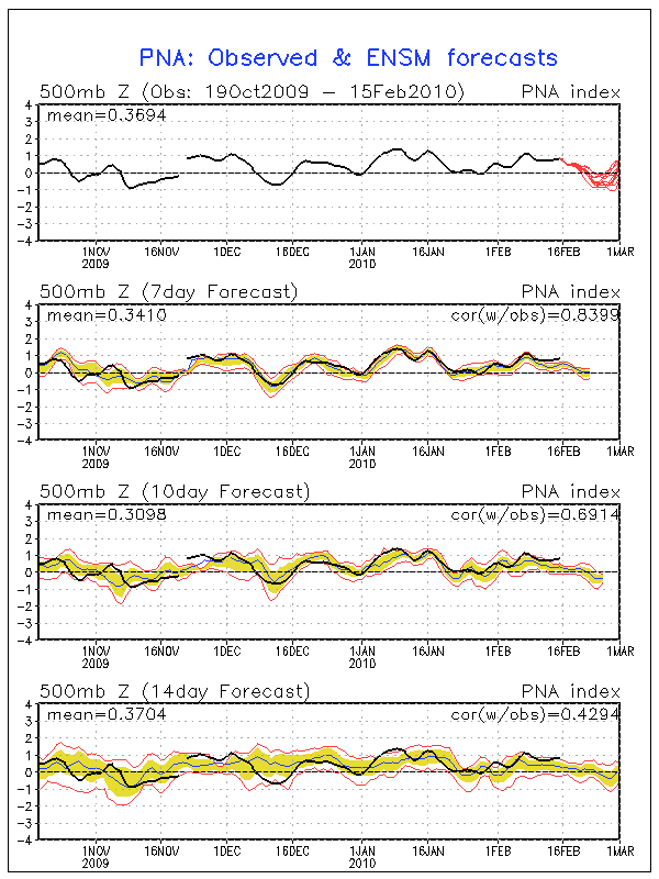
LC forecast are some what correct and in line with what Don Sutherland has stated regarding a relaxing of the blocking pattern. With that said, AO as well as NAO are still very negative. Also, while the GFS ensembles suggested yesterday that the PNA would begin it's fall to neutral, it still continues to climb slowly and remain positive...we shall see...Portastorm wrote:Didn't see anyone post this yet so I thought I would ... link below to Larry Cosgrove's latest blog entry. He's basically saying look for a major Arctic outbreak in the next 10 days which could set some new record lows in Texas. He's also bullish on one more winter storm. After about Feb. 25th though ... seems like he's suggesting the pattern relaxes and winter may be over (or at least return to normal climatological values).
The link:
http://www.examiner.com/x-3775-Houston- ... -600-PM-CT
Carla/Alicia/Jerry(In The Eye)/Michelle/Charley/Ivan/Dennis/Katrina/Rita/Wilma/Humberto/Ike/Harvey
Member: National Weather Association
Facebook.com/Weather Infinity
Twitter @WeatherInfinity
Member: National Weather Association
Facebook.com/Weather Infinity
Twitter @WeatherInfinity
-
wxman57

- Global Moderator

- Posts: 2621
- Joined: Thu Feb 04, 2010 5:34 am
- Location: Southwest Houston (Westbury)
- Contact:
Made up a meteogram of the raw data for you, Ed, mostly because I was curious about what the GFS was forecasting in terms of precipitation timing and the vertical profile.Ed Mahmoud wrote:Oh sugar. Fudge!
Only a tenth falls in the next 12 hours after the 850 mb freezing line comes through.
But still, an inch or two of snow on my birthday, I'd have to call in sick to work and frolic...
Meteogram based on 06Z GFS:

It does show temps above freezing. HOWEVER, the projected vertical profile is quite interesting. The GFS indicates temps aloft are all well below freezing before the precip ends, a snow signature. Here's the forecast sounding loop. Look for the images on Feb 28 - March 1 where the red/green lines are together (clouds/precip) to the left of the 0C diagonal isotherm line.
http://ready.arl.noaa.gov/readyout/7450 ... f_anim.gif
So the GFS is forecasting snow at 338 hrs. Interesting, but not something I'd consider likely when the GFS predicts a completely different weather for the same date every 6 hours. 00Z GFS had temps in the 50s for your birthday with little or no precip and certainly no chance of snow on the days surrounding March 1st.
Wouldn't you rather have nice 85 degree sunny weather on your birthday after this miserable cold and rainy winter?
-
redneckweather
- Posts: 1022
- Joined: Mon Feb 08, 2010 7:29 pm
- Location: Montgomery, Texas
- Contact:
My wife just sent me this picture of my inlaws house which is just off of Hwy. 105 West right before the San Jacinto River. The sleet was coming down pretty good last night and it looks to have accumulated on their roof! Who would of thunk it. I told her to climb up on the roof to make sure that wasn't snow. 

-
redneckweather
- Posts: 1022
- Joined: Mon Feb 08, 2010 7:29 pm
- Location: Montgomery, Texas
- Contact:
wxman, check yout pm's when you get a sec. Thanks.
-
wxman57
- Global Moderator
- Posts: 2621
- Joined: Thu Feb 04, 2010 5:34 am
- Location: Southwest Houston (Westbury)
- Contact:
Made a few meteograms off the 12Z GFS. Drier and warmer. I like it! But not nearly warm enough for me. Unfortunately, the GFS is performing so poorly beyond 3-4 days that I wouldn't even trust it for the coming weekend's weather much less 10-15 days from now.
GFS Meteogram of 12Z Raw Data:

GFS Extended Forecast out to 384 hrs:

GFS Meteogram of 12Z Raw Data:
GFS Extended Forecast out to 384 hrs:
-
srainhoutx
- Site Admin
- Posts: 19615
- Joined: Tue Feb 02, 2010 2:32 pm
- Location: Maggie Valley, NC
- Contact:
The GFS ensembles are showing a mighty big winter storm around February 24-27th. While we are getting later in the season, it is not out of the realm of possibilities that we may see one more big TX Winter Storm before we finally break this pattern that has plagued us since December. In the meantime, enjoy the sun and dry but cool weather this week. 
http://www.meteo.psu.edu/~gadomski/ENSH ... sloop.html
http://www.meteo.psu.edu/~gadomski/ENSP ... sloop.html
http://www.meteo.psu.edu/~gadomski/ENSH ... sloop.html
http://www.meteo.psu.edu/~gadomski/ENSP ... sloop.html
Carla/Alicia/Jerry(In The Eye)/Michelle/Charley/Ivan/Dennis/Katrina/Rita/Wilma/Humberto/Ike/Harvey
Member: National Weather Association
Facebook.com/Weather Infinity
Twitter @WeatherInfinity
Member: National Weather Association
Facebook.com/Weather Infinity
Twitter @WeatherInfinity
As we know Texas is a really big state so this could hold for DFW or the panhandle but not us.....guess we will just have to wait and see...I got Ed's attitude on this one.
-
wxman57
- Global Moderator
- Posts: 2621
- Joined: Thu Feb 04, 2010 5:34 am
- Location: Southwest Houston (Westbury)
- Contact:
They do show "something somewhere" in TX during that time, and some show nothing. Not much agreement other than that there may be a weather event somewhere in Texas the last week of February.srainhoutx wrote:The GFS ensembles are showing a mighty big winter storm around February 24-27th. While we are getting later in the season, it is not out of the realm of possibilities that we may see one more big TX Winter Storm before we finally break this pattern that has plagued us since December. In the meantime, enjoy the sun and dry but cool weather this week.
http://www.meteo.psu.edu/~gadomski/ENSH ... sloop.html
http://www.meteo.psu.edu/~gadomski/ENSP ... sloop.html
-
srainhoutx
- Site Admin
- Posts: 19615
- Joined: Tue Feb 02, 2010 2:32 pm
- Location: Maggie Valley, NC
- Contact:
Oh, I agree wxman57. I did state it is getting late in the season, but as you have posted on several occasions this pattern may not break until Mid March. Part of the reason behind posting the ensembles is to let folks make a judgment on their own. As you have pointed out many time, the GFS will show something somewhere in TX and will likely be right, but the wrong location. I just hope the mother lode of bottled up cold air doesn't try to descend S and we will all be in the deep freeze.wxman57 wrote:They do show "something somewhere" in TX during that time, and some show nothing. Not much agreement other than that there may be a weather event somewhere in Texas the last week of February.srainhoutx wrote:The GFS ensembles are showing a mighty big winter storm around February 24-27th. While we are getting later in the season, it is not out of the realm of possibilities that we may see one more big TX Winter Storm before we finally break this pattern that has plagued us since December. In the meantime, enjoy the sun and dry but cool weather this week.
http://www.meteo.psu.edu/~gadomski/ENSH ... sloop.html
http://www.meteo.psu.edu/~gadomski/ENSP ... sloop.html
Carla/Alicia/Jerry(In The Eye)/Michelle/Charley/Ivan/Dennis/Katrina/Rita/Wilma/Humberto/Ike/Harvey
Member: National Weather Association
Facebook.com/Weather Infinity
Twitter @WeatherInfinity
Member: National Weather Association
Facebook.com/Weather Infinity
Twitter @WeatherInfinity
-
jasonhoutx
- Posts: 9
- Joined: Thu Feb 04, 2010 8:42 pm
- Location: Friendswood
- Contact:
no one answered my question on the old board.
Is it possible that El Niño will stick around and we will have a summer like the last one? I can really dig another hot summer with no Hurricanes.
Is it possible that El Niño will stick around and we will have a summer like the last one? I can really dig another hot summer with no Hurricanes.
jasonhoutx wrote:no one answered my question on the old board.
Is it possible that El Niño will stick around and we will have a summer like the last one? I can really dig another hot summer with no Hurricanes.
DITTO!
-
TexasMetBlake
- Pro Met

- Posts: 839
- Joined: Wed Feb 03, 2010 7:03 pm
- Location: Spring/Woodlands
- Contact:
Jason, I think last summer has affected your ability to think properly. Your talking rubbish already! Another hot summer? Please tell me this is a joke. Am I on Candid Camera?
-
jasonhoutx
- Posts: 9
- Joined: Thu Feb 04, 2010 8:42 pm
- Location: Friendswood
- Contact:
nope, I love the sun and hot stuff. The more the better, thats why I live in Houston. The added benefit of last summers pattern is we didn't have to run from a stupid hurricane.Candy Cane wrote:Jason, I think last summer has affected your ability to think properly. Your talking rubbish already! Another hot summer? Please tell me this is a joke. Am I on Candid Camera?


El Niño is expected to fade by the summer. Keep in my mind, some really hot summers in Houston occurred in Neutral and La Niña. La Niña is hot and dry for Houston as well, but hurricane season is more active. Neutral is generally hot and dry, but hurricane season is a mixed bag, active or not as active. 1980 summer was very hot and it was Neutral. I remember the summer of 1997 was an El Niño and it was not that hot compared to 2009.jasonhoutx wrote:no one answered my question on the old board.
Is it possible that El Niño will stick around and we will have a summer like the last one? I can really dig another hot summer with no Hurricanes.
Last edited by Ptarmigan on Mon Feb 15, 2010 6:00 pm, edited 2 times in total.
-
TexasMetBlake
- Pro Met
- Posts: 839
- Joined: Wed Feb 03, 2010 7:03 pm
- Location: Spring/Woodlands
- Contact:
Well just for the record, I have been tickled pink by this winter. I'm loving this. I was so cotton-picken miserable last summer. You know what they say...payback's a *cough*jasonhoutx wrote:nope, I love the sun and hot stuff. The more the better, thats why I live in Houston. The added benefit of last summers pattern is we didn't have to run from a stupid hurricane.Candy Cane wrote:Jason, I think last summer has affected your ability to think properly. Your talking rubbish already! Another hot summer? Please tell me this is a joke. Am I on Candid Camera?
LOL!Candy Cane wrote:
Well just for the record, I have been tickled pink by this winter. I'm loving this. I was so cotton-picken miserable last summer. You know what they say...payback's a *cough*
-
srainhoutx
- Site Admin
- Posts: 19615
- Joined: Tue Feb 02, 2010 2:32 pm
- Location: Maggie Valley, NC
- Contact:
URGENT - WEATHER MESSAGE
NATIONAL WEATHER SERVICE BROWNSVILLE TX
134 PM CST MON FEB 15 2010
...FREEZING TEMPERATURES TONIGHT...
.CLEAR SKIES...DIMINISHING WINDS AND A COLD DRY AIR MASS SETTLING
OVER DEEP SOUTH TEXAS WILL SET THE STAGE FOR A LIGHT FREEZE
TONIGHT INTO TUESDAY MORNING. DEW POINTS CONTINUE TO FALL INTO THE
TEENS AND LOWER TWENTIES WITH NORTH WINDS TO DIMINISH AS STRONG
SURFACE HIGH PRESSURE MOVES INTO SOUTHWEST TEXAS. ALL AREAS OF
DEEP SOUTH TEXAS WITH EXCEPTION TO INLAND CAMERON...SOUTHERN HIDALGO
COUNTIES AND COASTAL WILLACY AND CAMERON COUNTIES CAN EXPECT A
FEW TO SEVERAL HOURS OF FREEZING TEMPERATURES.
TXZ248>254-160330-
/O.UPG.KBRO.FZ.A.0005.100216T0600Z-100216T1500Z/
/O.NEW.KBRO.FZ.W.0005.100216T0600Z-100216T1500Z/
ZAPATA-JIM HOGG-BROOKS-KENEDY-STARR-HIDALGO-INLAND WILLACY-
INCLUDING THE CITIES OF...ZAPATA...HEBBRONVILLE...FALFURRIAS...
SARITA...RIO GRANDE CITY...ROMA...MCALLEN...EDINBURG...PHARR...
MISSION...WESLACO...RAYMONDVILLE
134 PM CST MON FEB 15 2010
...FREEZE WARNING IN EFFECT FROM MIDNIGHT TONIGHT TO 9 AM CST
TUESDAY...
THE NATIONAL WEATHER SERVICE IN BROWNSVILLE HAS ISSUED A FREEZE
WARNING...WHICH IS IN EFFECT FROM MIDNIGHT TONIGHT TO 9 AM CST
TUESDAY. THE FREEZE WATCH IS NO LONGER IN EFFECT.
TEMPERATURES TO FALL STEADILY TONIGHT WITH MINIMUM TEMPERATURES
RANGING FROM 28 TO 32 DEGREES ACROSS MOST AREAS OF DEEP SOUTH
TEXAS WITH EXCEPTION TO SOUTHERN PORTIONS OF HIDALGO AND ALL OF
CAMERON COUNTIES AND ALONG THE IMMEDIATE COASTAL AREAS. UP TO 4
HOURS OF FREEZING TEMPERATURES ARE POSSIBLE WITH AS FEW AS TWO
HOURS IN URBAN AREAS AND AS MUCH AS 6 HOURS OR MORE IN RURAL AREAS.
Carla/Alicia/Jerry(In The Eye)/Michelle/Charley/Ivan/Dennis/Katrina/Rita/Wilma/Humberto/Ike/Harvey
Member: National Weather Association
Facebook.com/Weather Infinity
Twitter @WeatherInfinity
Member: National Weather Association
Facebook.com/Weather Infinity
Twitter @WeatherInfinity