
February Weather Discussion. Wild Winter Storms?
-
weatherguy425
- Pro Met

- Posts: 830
- Joined: Wed Feb 03, 2010 7:45 pm
- Location: Atlanta, Georgia
- Contact:
I am getting pretty much all sleet BUT the band has set up south of me so im only getting occasional light precip
-
srainhoutx

- Site Admin

- Posts: 19688
- Joined: Tue Feb 02, 2010 2:32 pm
- Location: Maggie Valley, NC
- Contact:
Just got a report from vbhoutex near Spring Branch. All sleet.
Carla/Alicia/Jerry(In The Eye)/Michelle/Charley/Ivan/Dennis/Katrina/Rita/Wilma/Humberto/Ike/Harvey
Member: National Weather Association
Facebook.com/Weather Infinity
Twitter @WeatherInfinity
Member: National Weather Association
Facebook.com/Weather Infinity
Twitter @WeatherInfinity

More sleet in Kingwood
Of course, HGX is behind the curve and isn't mentioning this in the forecast for tonight.
Of course, HGX is behind the curve and isn't mentioning this in the forecast for tonight.
-
weatherguy425
- Pro Met
- Posts: 830
- Joined: Wed Feb 03, 2010 7:45 pm
- Location: Atlanta, Georgia
- Contact:
Is there some sort of disturbance up in NE New Mexico, lookin at radar there's something up there...
I notice that too. Haven't checked anything yet since I've been busy with the sleet here. I've had heavy sleet showers to the point of minor accumulation on my vehicles here in the spring Branch area of Houston.weatherguy425 wrote:Is there some sort of disturbance up in NE New Mexico, lookin at radar there's something up there...
-
weatherguy425
- Pro Met
- Posts: 830
- Joined: Wed Feb 03, 2010 7:45 pm
- Location: Atlanta, Georgia
- Contact:
i read that on S2K...Lucky!! I've been on the northern fringe of the band the whole time!
-
srainhoutx
- Site Admin
- Posts: 19688
- Joined: Tue Feb 02, 2010 2:32 pm
- Location: Maggie Valley, NC
- Contact:
Appears to be a lot of uncertainty via the HPC Morning Prelim Discussion on just how things will play out this week...but the ECMWF and it's ensemble members are the choice for now...
PRELIMINARY EXTENDED FORECAST DISCUSSION
NWS HYDROMETEOROLOGICAL PREDICTION CENTER CAMP SPRINGS MD
818 AM EST MON FEB 15 2010
VALID 12Z FRI FEB 19 2010 - 12Z MON FEB 22 2010
GLOBAL MODELS AND ENSEMBLES SHOW FAIRLY GOOD AGREEMENT WITH THE
EXPECTED LARGE SCALE MEAN FLOW THRU THE PERIOD BUT THERE ARE SOME
SIGNIFICANT DETAIL ISSUES THAT WILL LIKELY TAKE A WHILE TO BE
RESOLVED. MEANS SHOW TWO PROMINENT CORES OF POSITIVE HGT
ANOMALIES... ONE NEAR THE DAVIS STRAIT AND ANOTHER CLOSE TO THE
ALASKA PANHANDLE. A MODERATE NEG ANOMALY CENTER SHOULD EVOLVE OFF
THE WEST COAST WHILE THE MAJORITY OF THE CONUS SHOULD BE UNDER NEG
HGT ANOMALIES AS WELL. THIS ANOMALY PATTERN IS ASSOC WITH REX
BLOCK TYPE CONFIGURATIONS COVERING THE CANADIAN
MARITIMES/GREENLAND REGION AND ERN PAC/NWRN NOAM. ALSO
UNDERCUTTING PAC FLOW IS FCST TO REACH THE WRN CONUS BY FRI-SAT.
HIGHEST UNCERTAINTY THIS FCST PERIOD INVOLVES THE EVOLUTION OF SRN
CANADA/NWRN CONUS ENERGY AS AN UPR HIGH CLOSES OFF NEAR OR JUST E
OF THE AK PANHANDLE... AND POSSIBLE INTERACTION WITH ERN PAC
ENERGY. LATEST ECMWF/GFS RUNS GENERALLY INDICATE MORE SRN
CANADA/NWRN CONUS ENERGY MAY RETROGRADE COMPARED THE 00Z UKMET/CMC
AND ENSEMBLE MEANS. LACK OF A WELL DEFINED CONSENSUS FAVORS A
BLEND AMONG THE RANGE OF CURRENT SOLNS. BY LATE IN THE PERIOD THE
00Z GFS BECOMES A NRN OUTLIER WITH ITS UPR LOW OFF THE WEST COAST
BY DAY 7 MON WITH THE 06Z GFS COMPARING MUCH BETTER TO
MODEL/ENSEMBLE CONSENSUS. HOWEVER TO DIFFERING DEGREES BOTH THE
00Z AND 06Z GFS RUNS BRING MORE RIDGING INTO THE ROCKIES/HIGH
PLAINS THAN MOST OTHER GUIDANCE. THE CONSENSUS APPEARS MORE
REASONABLE BASED ON TELECONNECTIONS RELATIVE TO AK PANHANDLE/DAVIS
STRAIT RIDGING... WHICH COMBINED WOULD FAVOR MODERATE TROFFING
FROM SRN CANADA AND NRN ROCKIES/PLAINS INTO THE ERN CONUS.
THERE IS FAIR CLUSTERING OF SOLNS WITH AN ERN PAC SHRTWV FCST TO
REACH THE WEST COAST BY DAY 5 SAT WITH 00Z/06Z GFS RUNS HOLDING
THIS ENERGY FARTHER NWWD AT THAT TIME COMPARED TO OTHER MODELS AND
ENSEMBLE MEANS. EWD MOTION OF THIS PROGRESSIVE SYSTEM SHOULD
BRING A WAVE INTO THE ERN CONUS BY DAY 7 MON. THE 00Z ECMWF SEEMS
TO OFFER AN ACCEPTABLE COMPROMISE TRACK IN LIGHT OF POOR ENSEMBLE
CLUSTERING AND UNCERTAINTY OVER THE EXACT ORIENTATION OF NRN
STREAM FLOW WHICH WILL HAVE SOME INFLUENCE ON SYSTEM EVOLUTION.
EARLIER IN THE FCST ANOTHER FEATURE OF NOTE IS A COMPACT
SHRTWV/UPR LOW FCST TO BE OVER ONTARIO/UPR GRTLKS AS OF DAY 3 THU.
OPERATIONAL MODELS DIVERGE CONSIDERABLY WITH TIMING/TRACK ALREADY
BY DAY 4 FRI. THE 00Z ECMWF IS WITHIN THE BROAD SOLN SPREAD...
BETWEEN THE FAST/NWD 06Z GFS AND SLOW 00Z GFS. THE UKMET/CMC ARE
FASTER THAN OTHER MODELS. HOPEFULLY 12Z GUIDANCE DEVELOPS SOME
IMPROVED CLUSTERING WITH THIS FEATURE.
THE UPDATED PRELIM FCST USES A BLEND INCORPORATING HALF WEIGHTING
OF THE 00Z ECMWF WITH THE REMAINDER CONSISTING OF THE 00Z
GEFS/ECMWF ENSEMBLE MEANS... AS THE 00Z ECMWF COMPARES BETTER TO
ENSEMBLES AND TELECONNECTIONS THAN SOME ASPECTS OF LATEST GFS RUNS
AND ENOUGH UNCERTAINTY EXISTS THRU THE PERIOD TO SMOOTH OUT SOME
OPERATIONAL MODEL DETAILS.
RAUSCH
Carla/Alicia/Jerry(In The Eye)/Michelle/Charley/Ivan/Dennis/Katrina/Rita/Wilma/Humberto/Ike/Harvey
Member: National Weather Association
Facebook.com/Weather Infinity
Twitter @WeatherInfinity
Member: National Weather Association
Facebook.com/Weather Infinity
Twitter @WeatherInfinity
Again, same system different city. My flight last Wednesday to Philly got cancelled and rescheduled to this wednesday. This one looks like it has a better chance. Are there any suprises I should expect?

FWIW 6z GFS brong back are fantasy winterstorm of the century that it showed a few days ago around the same time 

-
Portastorm

- Posts: 800
- Joined: Wed Feb 03, 2010 3:04 pm
- Location: Southwest Austin/Oak Hill, TX
- Contact:
Didn't see anyone post this yet so I thought I would ... link below to Larry Cosgrove's latest blog entry. He's basically saying look for a major Arctic outbreak in the next 10 days which could set some new record lows in Texas. He's also bullish on one more winter storm. After about Feb. 25th though ... seems like he's suggesting the pattern relaxes and winter may be over (or at least return to normal climatological values).
The link:
http://www.examiner.com/x-3775-Houston- ... -600-PM-CT
The link:
http://www.examiner.com/x-3775-Houston- ... -600-PM-CT
This is the part I read referring to that storm (Rain and thunderstorms will be the predicament this time around from TX and OK through the Deep South).......looks like normal rain and TS for Se Tx...Unless I read it wrong.Portastorm wrote:Didn't see anyone post this yet so I thought I would ... link below to Larry Cosgrove's latest blog entry. He's basically saying look for a major Arctic outbreak in the next 10 days which could set some new record lows in Texas. He's also bullish on one more winter storm. After about Feb. 25th though ... seems like he's suggesting the pattern relaxes and winter may be over (or at least return to normal climatological values).
The link:
http://www.examiner.com/x-3775-Houston- ... -600-PM-CT

Portastorm wrote:Didn't see anyone post this yet so I thought I would ... link below to Larry Cosgrove's latest blog entry. He's basically saying look for a major Arctic outbreak in the next 10 days which could set some new record lows in Texas. He's also bullish on one more winter storm. After about Feb. 25th though ... seems like he's suggesting the pattern relaxes and winter may be over (or at least return to normal climatological values).
The link:
http://www.examiner.com/x-3775-Houston- ... -600-PM-CT
-
srainhoutx
- Site Admin
- Posts: 19688
- Joined: Tue Feb 02, 2010 2:32 pm
- Location: Maggie Valley, NC
- Contact:
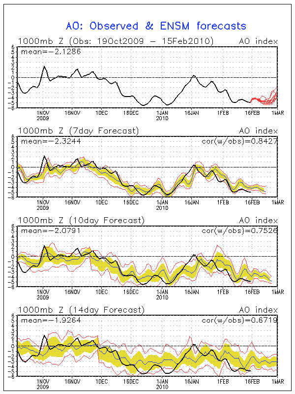
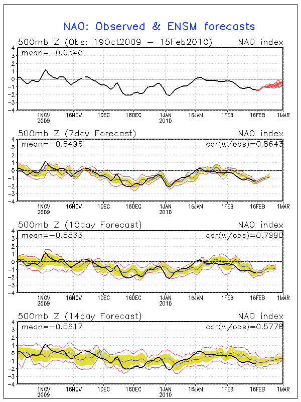
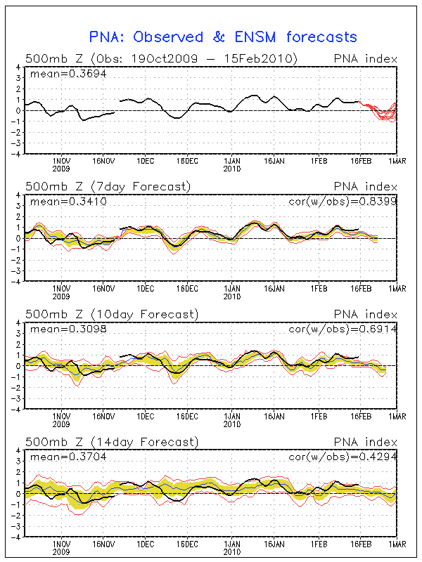
LC forecast are some what correct and in line with what Don Sutherland has stated regarding a relaxing of the blocking pattern. With that said, AO as well as NAO are still very negative. Also, while the GFS ensembles suggested yesterday that the PNA would begin it's fall to neutral, it still continues to climb slowly and remain positive...we shall see...Portastorm wrote:Didn't see anyone post this yet so I thought I would ... link below to Larry Cosgrove's latest blog entry. He's basically saying look for a major Arctic outbreak in the next 10 days which could set some new record lows in Texas. He's also bullish on one more winter storm. After about Feb. 25th though ... seems like he's suggesting the pattern relaxes and winter may be over (or at least return to normal climatological values).
The link:
http://www.examiner.com/x-3775-Houston- ... -600-PM-CT
Carla/Alicia/Jerry(In The Eye)/Michelle/Charley/Ivan/Dennis/Katrina/Rita/Wilma/Humberto/Ike/Harvey
Member: National Weather Association
Facebook.com/Weather Infinity
Twitter @WeatherInfinity
Member: National Weather Association
Facebook.com/Weather Infinity
Twitter @WeatherInfinity
-
wxman57

- Global Moderator

- Posts: 2621
- Joined: Thu Feb 04, 2010 5:34 am
- Location: Southwest Houston (Westbury)
- Contact:
Made up a meteogram of the raw data for you, Ed, mostly because I was curious about what the GFS was forecasting in terms of precipitation timing and the vertical profile.Ed Mahmoud wrote:Oh sugar. Fudge!
Only a tenth falls in the next 12 hours after the 850 mb freezing line comes through.
But still, an inch or two of snow on my birthday, I'd have to call in sick to work and frolic...
Meteogram based on 06Z GFS:

It does show temps above freezing. HOWEVER, the projected vertical profile is quite interesting. The GFS indicates temps aloft are all well below freezing before the precip ends, a snow signature. Here's the forecast sounding loop. Look for the images on Feb 28 - March 1 where the red/green lines are together (clouds/precip) to the left of the 0C diagonal isotherm line.
http://ready.arl.noaa.gov/readyout/7450 ... f_anim.gif
So the GFS is forecasting snow at 338 hrs. Interesting, but not something I'd consider likely when the GFS predicts a completely different weather for the same date every 6 hours. 00Z GFS had temps in the 50s for your birthday with little or no precip and certainly no chance of snow on the days surrounding March 1st.
Wouldn't you rather have nice 85 degree sunny weather on your birthday after this miserable cold and rainy winter?
-
redneckweather
- Posts: 1058
- Joined: Mon Feb 08, 2010 7:29 pm
- Location: Montgomery, Texas
- Contact:
My wife just sent me this picture of my inlaws house which is just off of Hwy. 105 West right before the San Jacinto River. The sleet was coming down pretty good last night and it looks to have accumulated on their roof! Who would of thunk it. I told her to climb up on the roof to make sure that wasn't snow. 

-
redneckweather
- Posts: 1058
- Joined: Mon Feb 08, 2010 7:29 pm
- Location: Montgomery, Texas
- Contact:
wxman, check yout pm's when you get a sec. Thanks.
-
wxman57
- Global Moderator
- Posts: 2621
- Joined: Thu Feb 04, 2010 5:34 am
- Location: Southwest Houston (Westbury)
- Contact:
Made a few meteograms off the 12Z GFS. Drier and warmer. I like it! But not nearly warm enough for me. Unfortunately, the GFS is performing so poorly beyond 3-4 days that I wouldn't even trust it for the coming weekend's weather much less 10-15 days from now.
GFS Meteogram of 12Z Raw Data:

GFS Extended Forecast out to 384 hrs:

GFS Meteogram of 12Z Raw Data:
GFS Extended Forecast out to 384 hrs:
-
srainhoutx
- Site Admin
- Posts: 19688
- Joined: Tue Feb 02, 2010 2:32 pm
- Location: Maggie Valley, NC
- Contact:
The GFS ensembles are showing a mighty big winter storm around February 24-27th. While we are getting later in the season, it is not out of the realm of possibilities that we may see one more big TX Winter Storm before we finally break this pattern that has plagued us since December. In the meantime, enjoy the sun and dry but cool weather this week. 
http://www.meteo.psu.edu/~gadomski/ENSH ... sloop.html
http://www.meteo.psu.edu/~gadomski/ENSP ... sloop.html
http://www.meteo.psu.edu/~gadomski/ENSH ... sloop.html
http://www.meteo.psu.edu/~gadomski/ENSP ... sloop.html
Carla/Alicia/Jerry(In The Eye)/Michelle/Charley/Ivan/Dennis/Katrina/Rita/Wilma/Humberto/Ike/Harvey
Member: National Weather Association
Facebook.com/Weather Infinity
Twitter @WeatherInfinity
Member: National Weather Association
Facebook.com/Weather Infinity
Twitter @WeatherInfinity
As we know Texas is a really big state so this could hold for DFW or the panhandle but not us.....guess we will just have to wait and see...I got Ed's attitude on this one.