
APRIL 2019: Warm & Muggy WX to End The Month
There’s a strong rain signal (especially for the northern half of the viewing area) coming up on the 24th/25th.
-
Texaspirate11

- Posts: 1278
- Joined: Tue Dec 31, 2013 12:24 am
- Contact:
This was in San Antonio on Saturday at 410 /Ingram Mall
this is the storm that went into Franklin
this is the storm that went into Franklin
- Attachments
-
Just because you're disabled, you don't have to be a victim
Be Weather Aware & Prepared!
Barbara Jordan Winner in Media
Disability Integration Consultant
Be Weather Aware & Prepared!
Barbara Jordan Winner in Media
Disability Integration Consultant
-
Katdaddy

- Global Moderator

- Posts: 2502
- Joined: Thu Feb 04, 2010 8:18 am
- Location: League City, Tx
- Contact:
A few showers and an isolated thunderstorms are possible this afternoon across SE TX. Strong to severe thunderstorms will fire along the dry line late this afternoon and move across the eastern half of TX through the night and early morning hours. The most significant severe weather will be N of Houston similar to last weekend with heavy rain being the main threat. Some large hail and damaging downburst winds will be possible with any thunderstorms that become severe. The main concern will be the timing of the line thunderstorms which will likely be during the Thursday morning Houston rush hour.
- Attachments
-
- Screen Shot 2019-04-17 at 5.23.30 AM.png (31.16 KiB) Viewed 3643 times
-
srainhoutx

- Site Admin

- Posts: 19615
- Joined: Tue Feb 02, 2010 2:32 pm
- Location: Maggie Valley, NC
- Contact:
It appears the greatest threat for this afternoon into early Thursday could be the heavy rainfall potential mainly along and North of a Columbus, Conroe, Lake Livingston line, where training thunderstorms could drop 2 to 4 inches of heavy rain in about a 6 hour timeframe. The Weather Prediction Center has outlined a Slight Risk for Excessive Rainfall across those portions of our Region.
- Attachments
-
Carla/Alicia/Jerry(In The Eye)/Michelle/Charley/Ivan/Dennis/Katrina/Rita/Wilma/Humberto/Ike/Harvey
Member: National Weather Association
Facebook.com/Weather Infinity
Twitter @WeatherInfinity
Member: National Weather Association
Facebook.com/Weather Infinity
Twitter @WeatherInfinity
Srain, I think I’m gonna need you to talk about what’s going on with the 0z Euro because wow  I understand that’s a ways out though and we have a busy weather day ahead today. Still would like your input if possible please.
-
stormlover
- Posts: 439
- Joined: Wed Dec 04, 2013 10:21 am
- Location: Lumberton TX
- Contact:
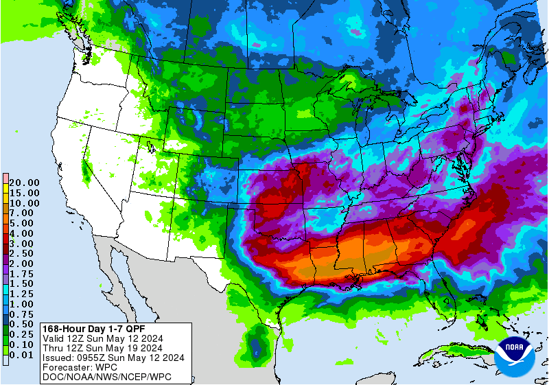
What is it showing I don’t see much of anything
Not much for your area, but a huge swath of 10-20” over south central Texas.
-
stormlover
- Posts: 439
- Joined: Wed Dec 04, 2013 10:21 am
- Location: Lumberton TX
- Contact:
Hrr has been struggling as of late
from NCEP Central Operations
NCEP Critical Weather Day Status
Critical Weather Day Has Been Declared
START: 1200Z Wed Apr 17 2019
END: 1200Z Thu Apr 18 2019
TYPE: Regional
WHO: NCEP, NWSTG, NCF, Southern Region
REASON: Enhanced risk for severe thunderstorms across northeast Texas, southeast Oklahoma into Arkansas.
-
srainhoutx
- Site Admin
- Posts: 19615
- Joined: Tue Feb 02, 2010 2:32 pm
- Location: Maggie Valley, NC
- Contact:
Wednesday morning weather briefing from Jeff:
Active weather increasingly likely tonight into Thursday morning.
Return flow off the Gulf of Mexico has resulted in a rapid influx of low to mid 60 degree dewpoints over the region overnight and this moisture feed will continue to deepen and expand today with PWS of 1.5-1.7 inches along the lower TX coast progged to advect toward the region this evening. Air mass will remain fairly capped today, but can’t rule out some showers under the capping inversion and maybe even a thunderstorms by early evening.
Tonight a line of thunderstorms will develop over SC TX and move eastward into SE TX likely in the 300-900am time frame on Thursday. The initial threat across our western and northwestern counties will be large hail and strong damaging winds, but as the line moves eastward early Thursday, the best upper level dynamics shift NE of the area and expect the line to weaken as it approaches I-45. At the same time, the line will become increasingly parallel to the upper level SW flow aloft and this will likely result in a decrease in the forward speed of the line and the potential for cells to train or move repeatedly over the same areas. This could allow a period of heavy rainfall Thursday morning for areas mainly N of I-10. Some of the latest guidance has come in a bit stronger with the heavy rainfall threat for areas N of I-10 with potential totals of 2-3 inches and isolated higher totals. There could be a fairly sharp gradient in the rainfall over the area with low amounts around Matagorda Bay and higher amounts to the N and NE from Huntsville over to Lake Livingston. Across Harris County, looks like .75 of an inch to 2 inches.
Excessive Rainfall Outlook (Tonight):
[/i]
Active weather increasingly likely tonight into Thursday morning.
Return flow off the Gulf of Mexico has resulted in a rapid influx of low to mid 60 degree dewpoints over the region overnight and this moisture feed will continue to deepen and expand today with PWS of 1.5-1.7 inches along the lower TX coast progged to advect toward the region this evening. Air mass will remain fairly capped today, but can’t rule out some showers under the capping inversion and maybe even a thunderstorms by early evening.
Tonight a line of thunderstorms will develop over SC TX and move eastward into SE TX likely in the 300-900am time frame on Thursday. The initial threat across our western and northwestern counties will be large hail and strong damaging winds, but as the line moves eastward early Thursday, the best upper level dynamics shift NE of the area and expect the line to weaken as it approaches I-45. At the same time, the line will become increasingly parallel to the upper level SW flow aloft and this will likely result in a decrease in the forward speed of the line and the potential for cells to train or move repeatedly over the same areas. This could allow a period of heavy rainfall Thursday morning for areas mainly N of I-10. Some of the latest guidance has come in a bit stronger with the heavy rainfall threat for areas N of I-10 with potential totals of 2-3 inches and isolated higher totals. There could be a fairly sharp gradient in the rainfall over the area with low amounts around Matagorda Bay and higher amounts to the N and NE from Huntsville over to Lake Livingston. Across Harris County, looks like .75 of an inch to 2 inches.
Excessive Rainfall Outlook (Tonight):
Carla/Alicia/Jerry(In The Eye)/Michelle/Charley/Ivan/Dennis/Katrina/Rita/Wilma/Humberto/Ike/Harvey
Member: National Weather Association
Facebook.com/Weather Infinity
Twitter @WeatherInfinity
Member: National Weather Association
Facebook.com/Weather Infinity
Twitter @WeatherInfinity

When’s the last time we had a storm system without a “sharp gradient in the rainfall?”
It’s always feast or famine it seems.
It’s always feast or famine it seems.
-
srainhoutx
- Site Admin
- Posts: 19615
- Joined: Tue Feb 02, 2010 2:32 pm
- Location: Maggie Valley, NC
- Contact:
Just 3 years ago today we were just a few hours away from the Tax Day Flood developing. I will gladly take not seeing a repeat of that kind of "feast"!
Carla/Alicia/Jerry(In The Eye)/Michelle/Charley/Ivan/Dennis/Katrina/Rita/Wilma/Humberto/Ike/Harvey
Member: National Weather Association
Facebook.com/Weather Infinity
Twitter @WeatherInfinity
Member: National Weather Association
Facebook.com/Weather Infinity
Twitter @WeatherInfinity
-
tireman4

- Global Moderator
- Posts: 4470
- Joined: Wed Feb 03, 2010 9:24 pm
- Location: Humble, Texas
- Contact:
000
FXUS64 KHGX 171614
AFDHGX
Area Forecast Discussion
National Weather Service Houston/Galveston TX
1114 AM CDT Wed Apr 17 2019
.NEAR TERM [Through Today]...
Surface analysis this morning shows a moisture axis basically
from the middle TX coast through central Texas as dewpoints
continue to rise. This nearly parallels the strong LLJ in place
over the Texas. Upper level jet streak can be seen on water vapor
imagery coming out of Mexico in West TX where there is a nice dry
slot. AMDAR soundings in the Houston area along with 12z soundings
from DRT and CRP show a substantial elevated mixed layer capping
inversion from 800-700mb with 700mb temps near 12C over much of
the area. SPC out look for today/tonight looks on track with
higher threat towards central TX where overnight squall line
should develop and move into the area. Lower threat in place back
closer to the coast where the cap will be stronger. 12Z WRF/HRRR
model runs show a trend of a strong squall line moving into the
Brazos Valley but then closer to 12Z Thur this line weakens
approaching Houston. This seems to be the models picking up that
the cap will work against any convection and cause a weakening
trend. Question marks remain as to when stronger upper level
forcing will arrive and it may be just enough out of phase that
storms weaken. There is still a strong jet and diffluent flow
aloft with lifting but the stronger PVA and cooling aloft lags by
3-6 hours. We will have to monitor these subtle trends going
forward for tonight`s forecast. Only changes to the forecast this
morning were to update based on ongoing trends and latest near
term guidance in temps/dewpoints/PoPs, etc.
Overpeck
&&
Both the Euro and GFS are showing potential next week for flooding rains especially in the western half of the area.
-
srainhoutx
- Site Admin
- Posts: 19615
- Joined: Tue Feb 02, 2010 2:32 pm
- Location: Maggie Valley, NC
- Contact:
The models are suggesting a stalled frontal boundary and a slow moving upper trough meandering across portions of South and Central Texas. That could be a focus of several rounds of thunderstorms and perhaps a more organized thunderstorm complex or two rolling out of Mexico into the Southern half of Texas. It is that time of year when we expect fronts to begin stalling and the longwave upper pattern to slow down as we head toward the later half of Spring. It's certainly worth monitoring, but nothing concrete at this time regarding our potential sensible weather for next week.
Carla/Alicia/Jerry(In The Eye)/Michelle/Charley/Ivan/Dennis/Katrina/Rita/Wilma/Humberto/Ike/Harvey
Member: National Weather Association
Facebook.com/Weather Infinity
Twitter @WeatherInfinity
Member: National Weather Association
Facebook.com/Weather Infinity
Twitter @WeatherInfinity
-
tireman4
- Global Moderator
- Posts: 4470
- Joined: Wed Feb 03, 2010 9:24 pm
- Location: Humble, Texas
- Contact:
000
FXUS64 KHGX 171721
AFDHGX
Area Forecast Discussion
National Weather Service Houston/Galveston TX
1221 PM CDT Wed Apr 17 2019
.AVIATION...
MVFR conditions will persist across a majority of the region until tomorrow
morning when the storm system moves to the east and out of our area.
Still expecting to see some SHRA development this afternoon with perhaps
slightly better coverage and possible TSRA around the CLL and UTS area.
SHRA/TSRA (some maybe strong/severe near and to the north of a Columbus
to Livingston line) will move west to east across the area late tonight
through tomorrow morning, roughly 07Z-13Z. Improving ceilings can be
expected to develop tomorrow after the storms move on through. 42
&&
Not too much in our area, but that could change.
-
- Information
-
Who is online
Users browsing this forum: Ahrefs [Bot], Bing [Bot], Semrush [Bot], TexasBreeze and 70 guests