
APRIL 2019: Warm & Muggy WX to End The Month

According to that map, not even an inch for me for the next week. Not impressive. We’ll see tomorrow morning if that’s realistic or not.
NWS:
"Again capping will be the main limiting factor. Upper level lift may just be enough out of phase to keep the cap in place."
-
srainhoutx

- Site Admin

- Posts: 19615
- Joined: Tue Feb 02, 2010 2:32 pm
- Location: Maggie Valley, NC
- Contact:
The Storm Prediction Center has shifted the Slight Risk for severe thunderstorms into Metro Houston in their latest Update. Make sure you have the means to receive Severe Weather Warnings throughout the night time hours.
- Attachments
-
Carla/Alicia/Jerry(In The Eye)/Michelle/Charley/Ivan/Dennis/Katrina/Rita/Wilma/Humberto/Ike/Harvey
Member: National Weather Association
Facebook.com/Weather Infinity
Twitter @WeatherInfinity
Member: National Weather Association
Facebook.com/Weather Infinity
Twitter @WeatherInfinity
-
stormlover
- Posts: 439
- Joined: Wed Dec 04, 2013 10:21 am
- Location: Lumberton TX
- Contact:
Srain so Beaumont area might not really get much by what the hrr is showing.
-
Andrew
- Site Admin
- Posts: 3440
- Joined: Wed Feb 03, 2010 9:46 pm
- Location: North-West Houston
- Contact:
Interesting to note the HRRR has low-level winds ramping up late overnight and hodographs look a lot more favorable. The main issue, similar to last time will be lack of CAPE and a decent cap. That will erode as upper level cools as the trough approaches, but it may be a little too late.
- Attachments
-
For Your Infinite Source For All Things Weather Visit Our Facebook
It’s looking pretty ominous out west. It may be quite an interesting night/early morning for our area. Stay safe and be weather aware!
-
Katdaddy

- Global Moderator

- Posts: 2502
- Joined: Thu Feb 04, 2010 8:18 am
- Location: League City, Tx
- Contact:
Setting the clock for 1:30AM weather check as a line of strong to severe storms push across TX. The radar is lit up across the Hill Country and NW TX. Have your phones charged and ready should a warning be issued in your area overnight. This line will push across NTX, NETX, SETX, ETX, S Central TX, and the Middle TX and Upper TX Coast into LA.
- Attachments
-
- Screen Shot 2019-04-17 at 10.11.04 PM.png (86.5 KiB) Viewed 3483 times
Frank Billingsley was committed to things holding together, citing strong southerly inflow. He did not mention the cap.
The model they use showed the line falling apart as it approached the metro area, then redeveloping again right on top of us as it exited. He said ‘don’t let that little break fool you, this is going to hold together.’ Then it showed a thin line of showers coming through with the front itself around 4pm.
The model also painted 1”totals across the area, with a band of 2” totals to the south and SW (Brazoria/Ft. Bend down to Wharton/Matagorda counties) and another one just to the east from Liberty northward. Frank said they may be indicative of some training.
The Rockets look good. Time to call it a night and I’ll let the thunder wake me up, if there is any...
One last peek - like a light switch a whole bunch of moderate showers just popped-up ahead of the main line and west of the I-35 corridor. It was like Boom - the lift moved in over there.

Message: NOAA-NWS-ALERTS-TX125CF2B24920.SevereThunderstormWarning.125CF2B24E98TX.HGXSVSHGX.7b5ea03a7014e7a9411b99dfa8943f21 from w-nws.webmaster@noaa.gov
Sent: 01:16 CDT on 04-18-2019
Effective: 01:16 CDT on 04-18-2019
Expires: 01:30 CDT on 04-18-2019
Event: Severe Thunderstorm Warning
Alert:
...A SEVERE THUNDERSTORM WARNING REMAINS IN EFFECT UNTIL 130 AM CDT
FOR NORTHERN BURLESON AND CENTRAL BRAZOS COUNTIES...
At 114 AM CDT, severe thunderstorms were located along a line
extending from near Hearne to near Caldwell, moving east at 50 mph.
Broadcast media reported a measured wind gust of 61 miles per hour
on the north side of Caldwell at 111 AM.
HAZARD...60 mph wind gusts.
SOURCE...Radar indicated.
IMPACT...Expect damage to roofs, siding, and trees.
Locations impacted include...
College Station, Bryan, Caldwell, Wixon Valley, Kyle Field, Wellborn
and Chriesman.
HAIL...<.75IN
WIND...60MPH
- Attachments
-
Impressive line of storms still sticking together.
- Attachments
-
61 mph gust reported in Caldwell, College Station to 49 mph gusts as of now
https://twitter.com/iembot_hgx/status/1 ... 1933617152
https://www.wrh.noaa.gov/zoa/getobext.php?sid=KCLL
https://www.wpc.ncep.noaa.gov/exper/lsr ... autoreload
https://twitter.com/iembot_hgx/status/1 ... 1933617152
https://www.wrh.noaa.gov/zoa/getobext.php?sid=KCLL
https://www.wpc.ncep.noaa.gov/exper/lsr ... autoreload
lightning, yowza http://map.blitzortung.org/#5.02/31.79/-95.56
animate their static TX map http://en.blitzortung.org/historical_maps.php?map=31
animate their static TX map http://en.blitzortung.org/historical_maps.php?map=31
https://twitter.com/iembot_hgx
Special Weather Statement
National Weather Service Houston/Galveston TX
310 AM CDT Thu Apr 18 2019
TXZ210>212-226-180845-
Waller TX-Wharton TX-Colorado TX-Austin TX-
310 AM CDT Thu Apr 18 2019
...SIGNIFICANT WEATHER ADVISORY FOR CENTRAL COLORADO...NORTH CENTRAL
WHARTON...SOUTHEASTERN AUSTIN AND SOUTHWESTERN WALLER COUNTIES UNTIL
345 AM CDT...
At 310 AM CDT, Doppler radar was tracking a strong thunderstorm 9
miles south of Columbus, moving east at 45 mph.
Winds in excess of 40 mph will be possible with this storm.
Locations impacted include...
Sealy, Columbus, Eagle Lake, San Felipe, Altair, Rock Island and
Sheridan.
PRECAUTIONARY/PREPAREDNESS ACTIONS...
This storm may intensify, so be certain to monitor local radio
stations and available television stations for additional information
and possible warnings from the National Weather Service.
&&
LAT...LON 2981 9654 2982 9609 2951 9611 2941 9664
2946 9668 2947 9668
TIME...MOT...LOC 0810Z 259DEG 37KT 2957 9655
$$
https://mesonet.agron.iastate.edu/wx/af ... 1904180822
Special Weather Statement
National Weather Service Houston/Galveston TX
322 AM CDT Thu Apr 18 2019
TXZ163-164-177>179-180900-
San Jacinto TX-Walker TX-Polk TX-Houston TX-Trinity TX-
322 AM CDT Thu Apr 18 2019
...SIGNIFICANT WEATHER ADVISORY FOR TRINITY...NORTHWESTERN SAN
JACINTO...EAST CENTRAL HOUSTON...CENTRAL POLK AND EAST CENTRAL WALKER
COUNTIES UNTIL 400 AM CDT...
At 322 AM CDT, Doppler radar was tracking a strong thunderstorm over
Sebastopol, or 21 miles northeast of Huntsville, moving east at 55
mph.
Winds in excess of 40 mph will be possible with this storm.
Locations impacted include...
Apple Springs, Onalaska, Corrigan, Groveton, Point Blank, Seven Oaks,
Sebastopol, northwestern West Livingston, Leggett, Moscow, Oakhurst
and Centralia.
A Severe Thunderstorm Watch remains in effect until 900 AM CDT for
southeastern Texas.
https://mesonet.agron.iastate.edu/wx/af ... 1904180835
Special Weather Statement
National Weather Service Houston/Galveston TX
335 AM CDT Thu Apr 18 2019
TXZ177>179-198-199-211>213-180915-
San Jacinto TX-Walker TX-Waller TX-Grimes TX-Polk TX-
Inland Harris TX-Montgomery TX-Austin TX-
335 AM CDT Thu Apr 18 2019
...SIGNIFICANT WEATHER ADVISORY FOR EAST CENTRAL AUSTIN...
SOUTHEASTERN GRIMES...WEST CENTRAL SAN JACINTO...WESTERN
MONTGOMERY...CENTRAL WALLER...SOUTHWESTERN POLK...NORTHWESTERN HARRIS
AND SOUTHEASTERN WALKER COUNTIES UNTIL 415 AM CDT...
At 334 AM CDT, Doppler radar was tracking a strong thunderstorm near
Cypress, or 11 miles north of Katy, moving east at 30 mph.
Winds in excess of 40 mph will be possible with this storm.
Locations impacted include...
Conroe, southeastern Huntsville, Katy, Tomball, Willis, Prairie View,
Pinehurst, The Woodlands, Hockley, Waller, Panorama Village,
Magnolia, Cut And Shoot, New Waverly, Pine Island, Coldspring,
Montgomery, Stagecoach, Pattison and Todd Mission.
A Severe Thunderstorm Watch remains in effect until 900 AM CDT for
southeastern Texas.
intensifying here in Cypress
https://twitter.com/iembot_hgx/status/1 ... 8084202497
https://twitter.com/iembot_hgx/status/1 ... 8084202497
Special Weather Statement
National Weather Service Houston/Galveston TX
342 AM CDT Thu Apr 18 2019
TXZ210>213-226-227-236-180915-
Waller TX-Inland Matagorda TX-Wharton TX-Colorado TX-
Inland Harris TX-Fort Bend TX-Austin TX-
342 AM CDT Thu Apr 18 2019
...SPECIAL WEATHER STATEMENT...
At 341 AM CDT, Doppler radar was tracking strong thunderstorms along
a line extending from near Pattison to 6 miles south of Pierce.
Movement was east at 30 mph.
Winds in excess of 30 mph will be possible with these storms.
Locations impacted include...
Western Rosenberg, Katy, El Campo, Wharton, Sealy, Brookshire, East
Bernard, Wallis, Fulshear, Simonton, San Felipe, Beasley, Pattison,
Kendleton, Orchard, Pierce, Weston Lakes, Boling-Iago, Cinco Ranch
and Egypt.
https://twitter.com/iembot_hgx/status/1 ... 0801333248
Area Forecast Discussion
National Weather Service Houston/Galveston TX
349 AM CDT Thu Apr 18 2019
.DISCUSSION...
An active morning across the northern third of the forecast area
where a ragged line of thunderstorms is currently advancing east
from roughly a Columbus to Conroe to Crockett line. The strongest
storms are advancing through Walker and Houston Counties at the
top of the 3 AM hour. Severe Thunderstorm Watch #81 has been pared
back to just include the northeastern CWA. The more southern
extension of the line is running into quite the capped downstream
environment and it is having a difficult time maintaining any
semblance of organization. Thunderstorms will be rolling through
the metro area within the next hour or two. Expect gusty winds to
30 mph and brief heavy rainfall that may cause street ponding or
minor flooding of low lying areas. The latest and greatest rapid
refresh high resolution modeling has this very ragged line moving
across the eastern CWA through 18Z. It also has the strong to
severe cells moving across CRP's CWA turning a bit north (left)
and merging with the southern tail of our line. This scenario
might produce a bow echo in the Matagorda Bay area that would push
across our western waters in the 11Z through 14Z range.
West to northwest winds will kick in later this morning and
strengthen this afternoon into the evening hours. Late afternoon
northwest to western county wind magnitudes may briefly achieve
Wind Advisory criteria, or sustained 25 mph with higher gusts,
before quickly coming down at sunset. As the core upper low moves
across and into the Piney Woods late this afternoon, there may be
some early afternoon wrap around cloud cover across the northern
tier counties with a low chance for a lingering shower or possible
thunderstorm. The day will warm into the mid 70s up north (more
clouds, rain) and the lower 80s down south (partial clearing, less
rain). Dry air advection will produce overnight clearing and
assist in lowering temperatures into the near sunrise lower to
middle 50s.
Friday will be a windy day with a more areawide Wind Advisory
likely required as daytime sustained northwest winds reach and/or
exceed sustained 20 to 25 mph. Despite mostly sunny skies, strong
northwesterly winds will keep the lower layer mixed enough to
thwart warming and keep afternoon temperature readings in the
lower to middle 70s.
A very nice Easter weekend with onshore flow returning Saturday
and strengthening during a mostly sunny and dry Easter Sunday.
Lower 60 F sunrise temperatures Easter Sunday will be around 10
degrees warmer than Saturday's min Ts...both days will warm into
the average lower 80s.
Early next week's precipitation chances will be on the rise each
subsequent day from Monday's slight chances to Wednesday's likely
probs. The impetus to return precipitation of (early week showers
transitioning to more stormy mid week conditions) will be the
slow deepening of a very slow eastern-moving upper trough from
the Great Basin Monday into western Texas Wednesday. An associated
surface reflection northeastern Mexico low may evolve an emanating
lower level trough/boundary across South Central and Central
Texas Tuesday into Wednesday. This lower level focus, in tandem
with a series of shortwave disturbances rounding the bend of the
western Texas 5H trough axis, will keep high to likely chance
POPs in the extended. 31
&&
.PRELIMINARY POINT TEMPS/POPS...
College Station (CLL) 76 50 73 48 81 / 50 0 0 0 0
Houston (IAH) 80 54 74 50 80 / 100 0 0 0 0
Galveston (GLS) 79 54 74 58 75 / 90 0 0 0 0
&&
.HGX WATCHES/WARNINGS/ADVISORIES...
TX...NONE.
GM...Small Craft Advisory until 10 AM CDT this morning for the
following zones: Coastal waters from Freeport to Matagorda
Ship Channel TX out 20 NM...Coastal waters from High Island
to Freeport TX out 20 NM...Galveston Bay...Matagorda Bay...
Waters from Freeport to Matagorda Ship Channel TX from 20
to 60 NM...Waters from High Island to Freeport TX from 20
to 60 NM.
&&
$$
Discussion...31
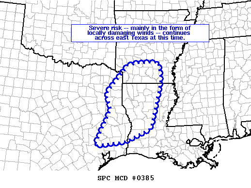
Mesoscale Discussion 0385
NWS Storm Prediction Center Norman OK
0351 AM CDT Thu Apr 18 2019
Areas affected...east Texas...southwestern and south-central
Arkansas...western and central Louisiana
Concerning...Severe Thunderstorm Watch 81...
Valid 180851Z - 181045Z
The severe weather threat for Severe Thunderstorm Watch 81
continues.
SUMMARY...Local severe risk -- predominantly comprised of
strong/damaging wind gusts -- continues across portions of WW 81.
DISCUSSION...The latest radar loop over the Arklatex/Sabine River
Valley region shows a line of storms -- with embedded complex
structures -- moving across east Texas toward the river. The line
itself is advancing eastward at roughly 30 kt, while individual
bowing elements within the line are moving northeastward with a more
rapid forward motion (near 40 kt). One such bowing segment --
crossing the Rusk County Texas vicinity -- appears to be producing
wind gusts near 40 kt. per recent obs from KTYR (Tyler, TX).
Storms should maintain intensity over the short term, especially
farther to the south where the instability axis appears broader, per
latest objective analyses. Farther north along the line however,
into the Arklatex region, a NNW-SSE instability gradient exists,
which suggests overall/gradual weakening of the line as it shifts
east with time. Still, we will continue to monitor the
environmental and convective evolution, with an eye toward possible
downstream WW issuance as convection begins to approach the eastern
edge of the current WW.
..Goss.. 04/18/2019
...Please see www.spc.noaa.gov for graphic product...
ATTN...WFO...JAN...LZK...LCH...SHV...HGX...
LAT...LON 33869377 33989325 34029205 33169190 30909252 30339385
30099549 31809466 32519494 33869377
-
Katdaddy
- Global Moderator
- Posts: 2502
- Joined: Thu Feb 04, 2010 8:18 am
- Location: League City, Tx
- Contact:
The line of thunderstorms are moving across Houston metro currently and has weakened slightly. Showers and thunderstorms extend back to San Antonio with some areas of heavy rain. Be safe and expect a slow messy morning commute. Skies will be clearing later this morning.
-
- Information
-
Who is online
Users browsing this forum: Ahrefs [Bot], Bing [Bot], Semrush [Bot] and 14 guests