
Cooler and drier air is filtering South behind the band of showers this morning. A stronger 850mb cold front is advancing South from N Texas and should arrive later today bringing some additional cooler and drier air for tonight into the Weekend. I emptied 0.63 of an inch from the gauge and the pollen seems to have washed away. Get out and enjoy the weather the next few days. That noisy sub tropical jet looks to bring a series of disturbances through our Region keeping some mid and high level clouds overhead and a chance of some rain closer to the Coast and offshore. No significant rain chances throughout the next 7 days.
Our next weather maker does show up in the extended range and may offer another severe weather episode toward the last week of March.
March 2019: Strong Front/Rain Chance To End March
-
srainhoutx

- Site Admin

- Posts: 19616
- Joined: Tue Feb 02, 2010 2:32 pm
- Location: Maggie Valley, NC
- Contact:
- Attachments
-
Carla/Alicia/Jerry(In The Eye)/Michelle/Charley/Ivan/Dennis/Katrina/Rita/Wilma/Humberto/Ike/Harvey
Member: National Weather Association
Facebook.com/Weather Infinity
Twitter @WeatherInfinity
Member: National Weather Association
Facebook.com/Weather Infinity
Twitter @WeatherInfinity

Yes, something changed on yesterday. We were supposed to get a squall line with a cold front, stalling near the coast, and then a push of colder air today to clear us out. Simple and straightforward.
Then yesterday, almost changing in real-time, front comes through with squall line, we cool into the 50’s, then front washes out with rising temperatures last night (that wasn’t expected), followed by another frontal push with storms this morning (again, never mentioned until last night), and then we do finally get the colder push today with the 850mb front. I thought, maybe I was losing it, but I went back and re-read Jeff’s emails and the NWS discussions, and I can’t find anything mentioning the initial front washing out and then another round of storms Thur AM. Crazy.
-
BlueJay
- Posts: 938
- Joined: Tue Mar 04, 2014 10:47 am
- Location: Alden Bridge-The Woodlands, Texas
- Contact:
jasons wrote: ↑Thu Mar 14, 2019 8:24 amYes, something changed on yesterday. We were supposed to get a squall line with a cold front, stalling near the coast, and then a push of colder air today to clear us out. Simple and straightforward.
Then yesterday, almost changing in real-time, front comes through with squall line, we cool into the 50’s, then front washes out with rising temperatures last night (that wasn’t expected), followed by another frontal push with storms this morning (again, never mentioned until last night), and then we do finally get the colder push today with the 850mb front. I thought, maybe I was losing it, but I went back and re-read Jeff’s emails and the NWS discussions, and I can’t find anything mentioning the initial front washing out and then another round of storms Thur AM. Crazy.
On KHOU, Chita and Blake reported that this would happen. They were pretty dead on with the timing also.
That's awesome!! I was surprised. Maybe I should watch KHOU moreBlueJay wrote: ↑Thu Mar 14, 2019 10:13 amOn KHOU, Chita and Blake reported that this would happen. They were pretty dead on with the timing also.jasons wrote: ↑Thu Mar 14, 2019 8:24 amYes, something changed on yesterday. We were supposed to get a squall line with a cold front, stalling near the coast, and then a push of colder air today to clear us out. Simple and straightforward.
Then yesterday, almost changing in real-time, front comes through with squall line, we cool into the 50’s, then front washes out with rising temperatures last night (that wasn’t expected), followed by another frontal push with storms this morning (again, never mentioned until last night), and then we do finally get the colder push today with the 850mb front. I thought, maybe I was losing it, but I went back and re-read Jeff’s emails and the NWS discussions, and I can’t find anything mentioning the initial front washing out and then another round of storms Thur AM. Crazy.
Nice few days ahead! Enjoy it everyone!

TG! DRY AIR at last in the Brazos Valley! Low dewpoints for the next week. The weeds are out of control, despite pre-emergence treatment. Am scalping the front lawn late this afternoon. Will have to raise the mower just to handle the back.
One of our yellow labs loves to roll on newly cut lawns. Her back will be green again for St. Patrick's Day!
A puzzling yellow orb is out in the sky this afternoon - enjoy this fine weather while it lasts!! Severe season and summer lurk in our future.
One of our yellow labs loves to roll on newly cut lawns. Her back will be green again for St. Patrick's Day!
A puzzling yellow orb is out in the sky this afternoon - enjoy this fine weather while it lasts!! Severe season and summer lurk in our future.


What a complicated start to meteorological Spring we've already had... yet the season has yet to officially begin.
Dixie Alley has lived up to its name so far the last few weeks. Even a confirmed large tornado hit just SW of Flint, MI earlier this evening. This 'bomb cyclone' meant business.
Unfortunately what was looking like a beautiful weekend earlier this week doesn't look quite as beautiful anymore. The front looks to stall closer to the coast than being pushed out further into the Gulf as models once indicated. Along the stationary front, a couple shortwave troughs will move through along the active SW flow throughout the weekend. Models have generally been keeping the bulk of the precipitation offshore, though recent runs are hinting that the precip may be closer to the coast/south of I-10. Tomorrow may be wetter than is being advertised, especially near the late afternoon and evening.
Hopefully Sunday we can squeeze out a decent day with a bit of sunshine.
Blake
Boomer Sooner
Boomer Sooner
These fronts are giving forecasters fits the past couple weeks. I don’t ever recall it being this bad.Belmer wrote: ↑Thu Mar 14, 2019 7:34 pm What a complicated start to meteorological Spring we've already had... yet the season has yet to officially begin.
Dixie Alley has lived up to its name so far the last few weeks. Even a confirmed large tornado hit just SW of Flint, MI earlier this evening. This 'bomb cyclone' meant business.
Unfortunately what was looking like a beautiful weekend earlier this week doesn't look quite as beautiful anymore. The front looks to stall closer to the coast than being pushed out further into the Gulf as models once indicated. Along the stationary front, a couple shortwave troughs will move through along the active SW flow throughout the weekend. Models have generally been keeping the bulk of the precipitation offshore, though recent runs are hinting that the precip may be closer to the coast/south of I-10. Tomorrow may be wetter than is being advertised, especially near the late afternoon and evening.
Hopefully Sunday we can squeeze out a decent day with a bit of sunshine.
Agreed - I have a few friends/connections that work at some NWS offices across the country and we've been discussing how complicated the past 3-4 months have been across much of the U.S., not just down here.
Mother Nature will do what Mother Nature wants to do.
Blake
Boomer Sooner
Boomer Sooner
NWS Omaha evacuated due to flooding, radar temporarily off - hope everyone stays safe
https://weather.com/news/news/2019-03-1 ... st-impacts
https://www.weather.gov/oax/
https://twitter.com/NWSOmaha
https://www.facebook.com/pg/NWSOmaha/posts
https://twitter.com/iembot_oax
https://water.weather.gov/ahps/?current ... fresh=true

NWS Hastings is backing up NWS Omaha. We will do the best we can to continue the flow of information. Please bear with us.
https://weather.com/news/news/2019-03-1 ... st-impacts
https://www.weather.gov/oax/
https://twitter.com/NWSOmaha
https://www.facebook.com/pg/NWSOmaha/posts
https://twitter.com/iembot_oax
https://water.weather.gov/ahps/?current ... fresh=true
Models are starting to trend wet for next weekend. Could be our next big rainmaker.
So just got a text from a friend saying its hailing at 249/spring cypress. I hadn't even checked the weather recently since it was cool and quiet.
Had a brief heavy downpour with some pea-size hail here in Pasadena. Quite a bit of lightning and thunder, too.
Blake
Boomer Sooner
Boomer Sooner
We’re over in SW Austin, went for a walk outside, 58 degrees but it was sleeting due to evaporative cooling.
It looks like a warming trend will begin by the middle part of this upcoming week. Temps should rebound to near normal or slightly above normal, but with the rising temperatures comes some good rain chances. Next Saturday looks particularly interesting to me right now.

Light Thundersleet in northern Grimes County (cue Cantore) 
from National Weather Service Missouri Basin River Forecast Center Twitter feed https://twitter.com/NWSMBRFCunome wrote: ↑Fri Mar 15, 2019 1:16 pm NWS Omaha evacuated due to flooding, radar temporarily off - hope everyone stays safe
https://weather.com/news/news/2019-03-1 ... st-impactsNWS Hastings is backing up NWS Omaha. We will do the best we can to continue the flow of information. Please bear with us.
https://www.weather.gov/oax/
https://twitter.com/NWSOmaha
https://www.facebook.com/pg/NWSOmaha/posts
https://twitter.com/iembot_oax
https://water.weather.gov/ahps/?current ... fresh=true
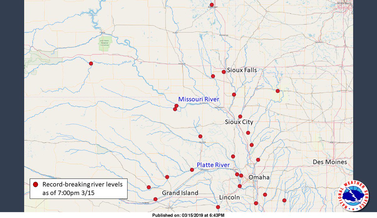
Preliminary record-breaking stages in the Missouri Basin
https://pbs.twimg.com/media/D1vMKbMXQAM8PiV.jpg


Nebraska and Iowa have some serious flooding right now.
all along the Mississippi Valley River Forecast Centers: https://water.weather.gov/ahps/region.php?rfc=mvrfc
while parts of TX in Moderate Drought, albeit slightly improved over precious week https://droughtmonitor.unl.edu/
while parts of TX in Moderate Drought, albeit slightly improved over precious week https://droughtmonitor.unl.edu/
-
srainhoutx
- Site Admin
- Posts: 19616
- Joined: Tue Feb 02, 2010 2:32 pm
- Location: Maggie Valley, NC
- Contact:
Fortunately an inversion remained high enough and light Northerly winds helped in mixing to keep smoke from the tank fires in Deer Park aloft. Winds should swing around to the NE and E as the day progresses and increase a bit.
We have a good stretch of weather ahead with just mid/high level clouds, but dry and comfortable. We may see increasing rain chances this weekend, but most of the heavier rain looks to be to our West and North as of this morning.
We have a good stretch of weather ahead with just mid/high level clouds, but dry and comfortable. We may see increasing rain chances this weekend, but most of the heavier rain looks to be to our West and North as of this morning.
Carla/Alicia/Jerry(In The Eye)/Michelle/Charley/Ivan/Dennis/Katrina/Rita/Wilma/Humberto/Ike/Harvey
Member: National Weather Association
Facebook.com/Weather Infinity
Twitter @WeatherInfinity
Member: National Weather Association
Facebook.com/Weather Infinity
Twitter @WeatherInfinity