Page 10 of 11
Re: NOVEMBER 2018: Slow Warming Trend/Thanksgiving Outlook
Posted: Thu Nov 15, 2018 2:18 pm
by Cpv17
snowman65 wrote:The longer range guidance will be playing cat up with these new Updated Teleconnection Indices. Impressive Hemispheric Pattern developing as we end November and begin December. Siberia is running well below normal temperature wise for mid November. A massive Northern latitude blocking regime establishes a very negative NAO and AO. That positive PNA suggests a Western Ridge and a negative EPO delivers storms system at the higher latitudes up and over the Bering Sea/Western Alaska dumping cold air across the North Pole into North America. Above normal snowfall across the Northern Hemisphere also suggests less airmass modification as we roll forward in time.
This is what I read: The longer range ndfgoijhdgh[ne[hoerhoh Novemebr and begin December. A massive i;apiohvihvfqhphnpuihafguiomvehp[iomhcwaemhe. Above normal snowfall.......


[/quote]
Just know that the temperatures of the oceans play a very important role in the weather globally, not just here.
Re: NOVEMBER 2018: Slow Warming Trend/Thanksgiving Outlook
Posted: Thu Nov 15, 2018 2:52 pm
by srainhoutx
Sorry snowman65. I was in a hurry and didn't explain myself very well. I'll dial back the technical jargon and keep it readable in the days ahead. Hectic times these days with everything with the Weather Forum future issues and Thanksgiving Holidays speeding toward us...

Re: NOVEMBER 2018: Slow Warming Trend/Thanksgiving Outlook
Posted: Thu Nov 15, 2018 3:09 pm
by Cpv17
All of the 12z model runs today backed away from cold air. The only model run today that showed any potential for Artic air was the 6z FV3. Plenty of rain around though for the next couple weeks.
Re: NOVEMBER 2018: Slow Warming Trend/Thanksgiving Outlook
Posted: Thu Nov 15, 2018 3:54 pm
by tireman4
NWS Houston Tonight Forecast
Re: NOVEMBER 2018: Slow Warming Trend/Thanksgiving Outlook
Posted: Thu Nov 15, 2018 4:05 pm
by Cpv17
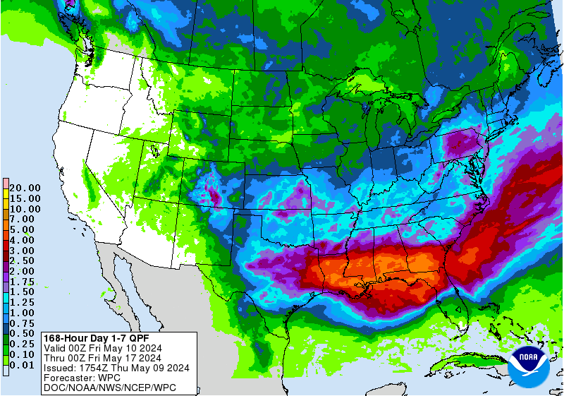
WPC keeps most of the rain offshore for next week.

Re: NOVEMBER 2018: Slow Warming Trend/Thanksgiving Outlook
Posted: Fri Nov 16, 2018 6:52 am
by cperk
srainhoutx wrote:MontgomeryCoWx wrote:December is starting to look very cold and stormy! We may be locking in an epic Winter in a couple weeks.
Long range has flipped to much Colder.
The longer range guidance will be playing cat up with these new Updated Teleconnection Indices. Impressive Hemispheric Pattern developing as we end November and begin December. Siberia is running well below normal temperature wise for mid November. A massive Northern latitude blocking regime establishes a very negative NAO and AO. That positive PNA suggests a Western Ridge and a negative EPO delivers storms system at the higher latitudes up and over the Bering Sea/Western Alaska dumping cold air across the North Pole into North America. Above normal snowfall across the Northern Hemisphere also suggests less airmass modification as we roll forward in time.
This is why we need our forum and I'm willing to contribute to keep if that's what it comes down to.
Re: NOVEMBER 2018: Slow Warming Trend/Thanksgiving Outlook
Posted: Fri Nov 16, 2018 8:58 am
by jasons2k
The AFD was very detailed. Here is sorta the summary at the end:
Fortunately the models continue to show the highest rainfall amounts well off the
coast in the Gulf that the area should avoid the heavy rainfall
threat. That`s not to say we will not get any rain in the area
because we are still looking at a good 1 to 3 inches of rain
across the area for the 5 day period next week. It just looks like
those isolated higher amounts will stay of the coast and not be a
problem for the area. Keep in mind this is still the extended
forecast and we`ve seen the second shortwave trough change in
timing for Wed/Thur quite a bit with the last day or two`s worth
of model runs.
Re: NOVEMBER 2018: Slow Warming Trend/Thanksgiving Outlook
Posted: Fri Nov 16, 2018 9:22 am
by tireman4
srainhoutx wrote:Sorry snowman65. I was in a hurry and didn't explain myself very well. I'll dial back the technical jargon and keep it readable in the days ahead. Hectic times these days with everything with the Weather Forum future issues and Thanksgiving Holidays speeding toward us...

It happens to all pro mets Srain. Even Dr. Frank was chastised about meteorological jargon..LOL ( USA Today Weather book about his dealings with the public after Camille)...lol..we love ya
Re: NOVEMBER 2018: Slow Warming Trend/Thanksgiving Outlook
Posted: Fri Nov 16, 2018 9:24 am
by tireman4
HGX Weather Forecast...
Re: NOVEMBER 2018: Slow Warming Trend/Thanksgiving Outlook
Posted: Fri Nov 16, 2018 10:42 am
by BlueJay
Just got done un-blanketing in the yard. It looks like all my plants, with the exception of the sweet potato vine, survived our first freeze.
So glad to see the sun.
Re: NOVEMBER 2018: Slow Warming Trend/Thanksgiving Outlook
Posted: Fri Nov 16, 2018 12:02 pm
by tireman4
Another interesting viewpoint of Winter...
Re: NOVEMBER 2018: Slow Warming Trend/Thanksgiving Outlook
Posted: Fri Nov 16, 2018 1:17 pm
by Cpv17
jasons wrote:The AFD was very detailed. Here is sorta the summary at the end:
Fortunately the models continue to show the highest rainfall amounts well off the
coast in the Gulf that the area should avoid the heavy rainfall
threat. That`s not to say we will not get any rain in the area
because we are still looking at a good 1 to 3 inches of rain
across the area for the 5 day period next week. It just looks like
those isolated higher amounts will stay of the coast and not be a
problem for the area. Keep in mind this is still the extended
forecast and we`ve seen the second shortwave trough change in
timing for Wed/Thur quite a bit with the last day or two`s worth
of model runs.
The 12z Euro is more aggressive with rain.
Re: NOVEMBER 2018: Slow Warming Trend/Thanksgiving Outlook
Posted: Fri Nov 16, 2018 2:44 pm
by tireman4
Average High Temperature- October 15 to November 15th...Now, Srain can extrapolate more on this since he is a pro met and a long range guy, but look at the cool colors...

Re: NOVEMBER 2018: Slow Warming Trend/Thanksgiving Outlook
Posted: Fri Nov 16, 2018 2:52 pm
by snowman65
tireman4 wrote:Average High Temperature- October 15 to November 15th...Now, Srain can extrapolate more on this since he is a pro met and a long range guy, but look at the cool colors...

And here I was thinking all the orange in Florida were areas of voter fraud...lol. But yes, Srain is the one to go to for enhanced insight

Re: NOVEMBER 2018: Slow Warming Trend/Thanksgiving Outlook
Posted: Fri Nov 16, 2018 3:11 pm
by Cpv17
snowman65 wrote:tireman4 wrote:Average High Temperature- October 15 to November 15th...Now, Srain can extrapolate more on this since he is a pro met and a long range guy, but look at the cool colors...

And here I was thinking all the orange in Florida were areas of voter fraud...lol. But yes, Srain is the one to go to for enhanced insight

I really don’t see any signs on the models of any cold air coming the next couple weeks and neither does the CPC. We need cold air to build in our source region (western and northern Canada) and a 1050mb+ high pressure to drive it south and I don’t see any signs of that happening on the models. The FV3 hinted at it a couple days ago, but now has lost it.


Re: NOVEMBER 2018: Slow Warming Trend/Thanksgiving Outlook
Posted: Fri Nov 16, 2018 3:28 pm
by tireman4
NWS Weekend Outlook
Re: NOVEMBER 2018: Slow Warming Trend/Thanksgiving Outlook
Posted: Fri Nov 16, 2018 4:47 pm
by don
I really don’t see any signs on the models of any cold air coming the next couple weeks and neither does the CPC. We need cold air to build in our source region (western and northern Canada) and a 1050mb+ high pressure to drive it south and I don’t see any signs of that happening on the models. The FV3 hinted at it a couple days ago, but now has lost it.
It looks like our next shot of cold air (and maybe a storm)
may arrive by the first half of December, as usual models will flip flop as they try to resolve this complex pattern. Btw we don't need a 1050mb+ high to get cold enough for a winter storm in fact a high too strong can make us too dry for precipitation to form. Even a high in the upper 1030mb's can be cold enough for winter weather as long as you have a storm system that can "dig" enough to tap into the cold air.
Re: NOVEMBER 2018: Slow Warming Trend/Thanksgiving Outlook
Posted: Fri Nov 16, 2018 6:03 pm
by Cpv17
don wrote:I really don’t see any signs on the models of any cold air coming the next couple weeks and neither does the CPC. We need cold air to build in our source region (western and northern Canada) and a 1050mb+ high pressure to drive it south and I don’t see any signs of that happening on the models. The FV3 hinted at it a couple days ago, but now has lost it.
It looks like our next shot of cold air (and maybe a storm)
may arrive by the first half of December, as usual models will flip flop as they try to resolve this complex pattern. Btw we don't need a 1050mb+ high to get cold enough for a winter storm in fact a high too strong can make us too dry for precipitation to form. Even a high in the upper 1030mb's can be cold enough for winter weather as long as you have a storm system that can "dig" enough to tap into the cold air.
I’m talking about when the high is in Canada though or near Montana/Wyoming. I know we would probably be too dry if it were that strong anywhere near Texas. 1030-1040mb seems to be the right strength around here, but correct me if I’m wrong.
Re: NOVEMBER 2018: Wet & Chilly Wx Returns/Thanksgiving Outl
Posted: Sat Nov 17, 2018 8:36 am
by srainhoutx
One last today of 'warm' temperature and partly cloudy conditions before a shallow modified Canadian front arrives tomorrow afternoon/evening. This shallow cold front will drop temperatures into the 50's for daytime highs and possibly 40's for morning lows, particularly N of I-10 throughout most of the Thanksgiving Holiday week. Rain chances return tomorrow afternoon along and ahead of the cold front and rain chances remain in the forecast through at least Thanksgiving Morning. The can be summarized as wet & dreary as a series of upper air disturbances roll across our Region and a very pesky Coastal trough keeps our weather unsettled. The heaviest rainfall does appear to remain offshore, but there is a chance for elevated storms particularly on the busy Wednesday before Thanksgiving Travel Day. Pack your patience if you plan on flying out of SE Texas Wednesday!
Re: NOVEMBER 2018: Wet & Chilly Wx Returns/Thanksgiving Outl
Posted: Sat Nov 17, 2018 12:38 pm
by Katdaddy
Enjoy this beautiful mild Saturday across SE TX.


