
OCTOBER 2018 - Stormy Halloween
I don’t really know what to think of it, but kind of out of nowhere the 12z GFS has a lot of rain for western parts of the viewing area next weekend.

Hmmm...I'm salivating for a potential week of NW flow and a crisp weekend. It may be just the front. Don't mess this up!Cpv17 wrote:I don’t really know what to think of it, but kind of out of nowhere the 12z GFS has a lot of rain for western parts of the viewing area next weekend.
I see it now - the fly in the ointment is moisture from a Pacific hurricane that lands ashore in Mexico. haha It will probably evaporate in the next GFS run! Having said that I noticed the Euro brings the storm ashore on the same spot in the Baja Peninsula.

-
srainhoutx

- Site Admin

- Posts: 19616
- Joined: Tue Feb 02, 2010 2:32 pm
- Location: Maggie Valley, NC
- Contact:
EPAC Hurricane Sergio and its remnants likely will be a wildcard regarding our sensible weather next weekend as it merges with that Fall Cold Front. Over running clouds and possibly mid/upper level moisture and strong fronts can lead to rainfall after the front passes giving us cool and gloomy weather we often see in Fall and in Winter.
Carla/Alicia/Jerry(In The Eye)/Michelle/Charley/Ivan/Dennis/Katrina/Rita/Wilma/Humberto/Ike/Harvey
Member: National Weather Association
Facebook.com/Weather Infinity
Twitter @WeatherInfinity
Member: National Weather Association
Facebook.com/Weather Infinity
Twitter @WeatherInfinity
Yeah, a dreary mid level moisture weekend on tap in a week. A real shame, because Friday's front would have been pretty bone dry otherwise.srainhoutx wrote:EPAC Hurricane Sergio and its remnants likely will be a wildcard regarding our sensible weather next weekend as it merges with that Fall Cold Front. Over running clouds and possibly mid/upper level moisture and strong fronts can lead to rainfall after the front passes giving us cool and gloomy weather we often see in Fall and in Winter.
Sergio is currently a major EPAC fish storm poised to take a turn NE and weaken. It certainly would be in position to ruin next weekend's BBQs and other outdoor activities.
https://www.nhc.noaa.gov/graphics_ep1.s ... e#contents
Go away.
Last edited by DoctorMu on Sat Oct 06, 2018 5:16 pm, edited 1 time in total.
Sometimes these EPAC storms can cause copious amounts of rainfall in Texas when they go into Mexico like that so it’s just something to keep an eye on.DoctorMu wrote:Yeah, a dreary mid level moisture weekend on tap in a week. A real shame, because Friday's front would have been pretty bone dry otherwise.srainhoutx wrote:EPAC Hurricane Sergio and its remnants likely will be a wildcard regarding our sensible weather next weekend as it merges with that Fall Cold Front. Over running clouds and possibly mid/upper level moisture and strong fronts can lead to rainfall after the front passes giving us cool and gloomy weather we often see in Fall and in Winter.
Sergio is currently a major EPAC fish storm poised to take a turn NE and weaken. It certainly would be posed to ruin next weekend's BBQs and other outdoor activities.
https://www.nhc.noaa.gov/graphics_ep1.s ... e#contents
Go away.
-
srainhoutx
- Site Admin
- Posts: 19616
- Joined: Tue Feb 02, 2010 2:32 pm
- Location: Maggie Valley, NC
- Contact:
Advisories from the NHC have been issued for Potential Tropical Cyclone #14 in the NW Caribbean Sea.
POTENTIAL TROPICAL CYCLONE FOURTEEN DISCUSSION NUMBER 1
NWS NATIONAL HURRICANE CENTER MIAMI FL AL142018
400 PM CDT SAT OCT 06 2018
SATELLITE IMAGERY AND SURFACE OBSERVATIONS INDICATE THAT THE
CIRCULATION OF THE LOW PRESSURE AREA IN THE NORTHWESTERN CARIBBEAN
SEA IS GETTING BETTER DEFINED, AND THAT THE ASSOCIATED CONVECTION
IS BECOMING BETTER ORGANIZED. WHILE THE SYSTEM IS CURRENTLY NOT
WELL ENOUGH ORGANIZED TO CALL IT A TROPICAL DEPRESSION, CURRENT
INDICATIONS IN THE GLOBAL MODELS AND THE INTENSITY GUIDANCE ARE THAT
THE SYSTEM WILL DEVELOP INTO A TROPICAL CYCLONE WITHIN 24 H AND
COULD BRING TROPICAL STORM CONDITIONS TO PORTIONS OF WESTERN CUBA
AND THE NORTHEASTERN YUCATAN PENINSULA. BASED ON THE NEED FOR
WARNINGS AND WATCHES IN THESE AREAS, ADVISORIES ARE BEING INITIATED
ON POTENTIAL TROPICAL CYCLONE FOURTEEN.
ALTHOUGH THE INTENSITY GUIDANCE IS IN EXCELLENT AGREEMENT THAT THE
SYSTEM SHOULD STRENGTHEN THROUGH THE FORECAST PERIOD, THE GLOBAL
MODELS INDICATE THAT SHEAR CAUSED BY AN UPPER-LEVEL TROUGH OVER THE
GULF OF MEXICO WILL PERSIST THROUGH AT LEAST 48 H. IN ADDITION, THE
STRONGEST WINDS ARE CURRENTLY WELL REMOVED FROM THE CENTER, WHICH IS
LIKELY TO SLOW DEVELOPMENT. BASED ON THIS, THE INTENSITY FORECAST
IS IN THE LOWER PART OF THE GUIDANCE ENVELOPE THROUGH 48 H, AND THEN
SHOWS A FASTER RATE OF DEVELOPMENT FROM 48-96 H WHEN THE SHEAR IS
FORECAST TO DIMINISH. THE INTENSITY FORECAST IS CLOSEST TO A BLEND
OF THE IVCN AND HCCA CONSENSUS MODELS.
FOR THE FIRST 24-48 H, THE DISTURBANCE SHOULD MOVE GENERALLY
NORTHWARD ON THE WESTERN SIDE OF A WEAK MID-LEVEL RIDGE OVER THE
CARIBBEAN SEA. AFTER THAT TIME, A LARGE MID-LATITUDE TROUGH OVER
THE CENTRAL UNITED STATES AND A MID- TO UPPER-LEVEL RIDGE OVER THE
WESTERN ATLANTIC SHOULD STEER THE SYSTEM GENERALLY NORTHWARD AT A
FASTER FORWARD SPEED, WITH THE SYSTEM EXPECTED TO MOVE NEAR OR OVER
THE NORTHERN GULF COAST IN ABOUT 96 H. AFTER LANDFALL, THE SYSTEM
IS LIKELY TO RECURVE NORTHEASTWARD INTO THE WESTERLIES. THE TRACK
GUIDANCE IS IN GOOD OVERALL AGREEMENT WITH THIS SCENARIO. HOWEVER,
IT SHOULD BE NOTED THAT THERE IS A NEARLY 300 N MI CROSS-TRACK
SPREAD IN THE GUIDANCE AT THE 96-H POINT. THE FORECAST TRACK LIES
JUST TO THE WEST OF THE VARIOUS CONSENSUS MODELS.
KEY MESSAGES FOR POTENTIAL TROPICAL CYCLONE FOURTEEN:
1. THIS SYSTEM IS EXPECTED TO PRODUCE HEAVY RAINFALL AND FLASH
FLOODING OVER PORTIONS OF CENTRAL AMERICA, WESTERN CUBA, AND THE
NORTHEASTERN YUCATAN PENINSULA OF MEXICO DURING THE NEXT COUPLE OF
DAYS. THE SYSTEM IS ALSO FORECAST TO BECOME A TROPICAL STORM BY
SUNDAY NIGHT AND TROPICAL STORM CONDITIONS ARE EXPECTED OVER
PORTIONS OF WESTERN CUBA WHERE A TROPICAL STORM WARNING IS IN
EFFECT.
2. THE SYSTEM COULD BRING STORM SURGE, RAINFALL, AND WIND IMPACTS TO
PORTIONS OF THE NORTHERN GULF COAST BY MID-WEEK, ALTHOUGH IT IS TOO
SOON TO SPECIFY THE EXACT LOCATION AND MAGNITUDE OF THESE IMPACTS.
RESIDENTS IN THESE AREAS SHOULD MONITOR THE PROGRESS OF THIS SYSTEM.
FORECAST POSITIONS AND MAX WINDS
INIT 06/2100Z 18.0N 86.6W 25 KT 30 MPH...POTENTIAL TROP CYCLONE
12H 07/0600Z 18.7N 86.7W 25 KT 30 MPH
24H 07/1800Z 19.9N 86.6W 30 KT 35 MPH...TROPICAL CYCLONE
36H 08/0600Z 21.0N 86.6W 35 KT 40 MPH
48H 08/1800Z 22.5N 86.7W 40 KT 45 MPH
72H 09/1800Z 26.0N 87.5W 55 KT 65 MPH
96H 10/1800Z 30.5N 86.5W 60 KT 70 MPH
120H 11/1800Z 35.5N 81.5W 30 KT 35 MPH...INLAND
$$
FORECASTER BEVEN
Carla/Alicia/Jerry(In The Eye)/Michelle/Charley/Ivan/Dennis/Katrina/Rita/Wilma/Humberto/Ike/Harvey
Member: National Weather Association
Facebook.com/Weather Infinity
Twitter @WeatherInfinity
Member: National Weather Association
Facebook.com/Weather Infinity
Twitter @WeatherInfinity
Cpv17 wrote:Sometimes these EPAC storms can cause copious amounts of rainfall in Texas when they go into Mexico like that so it’s just something to keep an eye on.DoctorMu wrote:Yeah, a dreary mid level moisture weekend on tap in a week. A real shame, because Friday's front would have been pretty bone dry otherwise.srainhoutx wrote:EPAC Hurricane Sergio and its remnants likely will be a wildcard regarding our sensible weather next weekend as it merges with that Fall Cold Front. Over running clouds and possibly mid/upper level moisture and strong fronts can lead to rainfall after the front passes giving us cool and gloomy weather we often see in Fall and in Winter.
Sergio is currently a major EPAC fish storm poised to take a turn NE and weaken. It certainly would be posed to ruin next weekend's BBQs and other outdoor activities.
https://www.nhc.noaa.gov/graphics_ep1.s ... e#contents
Go away.
Absolutely. Especially this time of year. If that moisture is caught up in a front or the SJT, there is significant potential for entraining.
-
srainhoutx
- Site Admin
- Posts: 19616
- Joined: Tue Feb 02, 2010 2:32 pm
- Location: Maggie Valley, NC
- Contact:
Tropical Storm Michael Tropical Cyclone Update NWS National Hurricane Center Miami FL AL142018 1155 AM CDT Sun Oct 07 2018 ...DEPRESSION STRENGTHENS TO A TROPICAL STORM... Satellite wind data indicate that the depression has strengthened into Tropical Storm Michael. The maximum winds are estimated to be 40 mph (65 km/h) with higher gusts. An Air Force Reserve Hurricane Hunter aircraft is currently en route to investigate Michael. SUMMARY OF 1155 AM CDT...1655 UTC...INFORMATION ----------------------------------------------- LOCATION...19.2N 86.9W ABOUT 90 MI...145 KM S OF COZUMEL MEXICO ABOUT 225 MI...365 KM SW OF THE WESTERN TIP OF CUBA MAXIMUM SUSTAINED WINDS...40 MPH...65 KM/H PRESENT MOVEMENT...N OR 360 DEGREES AT 5 MPH...7 KM/H MINIMUM CENTRAL PRESSURE...1004 MB...29.65 INCHES $$ Forecaster Brown
Carla/Alicia/Jerry(In The Eye)/Michelle/Charley/Ivan/Dennis/Katrina/Rita/Wilma/Humberto/Ike/Harvey
Member: National Weather Association
Facebook.com/Weather Infinity
Twitter @WeatherInfinity
Member: National Weather Association
Facebook.com/Weather Infinity
Twitter @WeatherInfinity
Bring on the freezing cold weather. I've had enough of this miserable summer already. I dont want to thaw out until next May.


EURO
UKMET

GFS

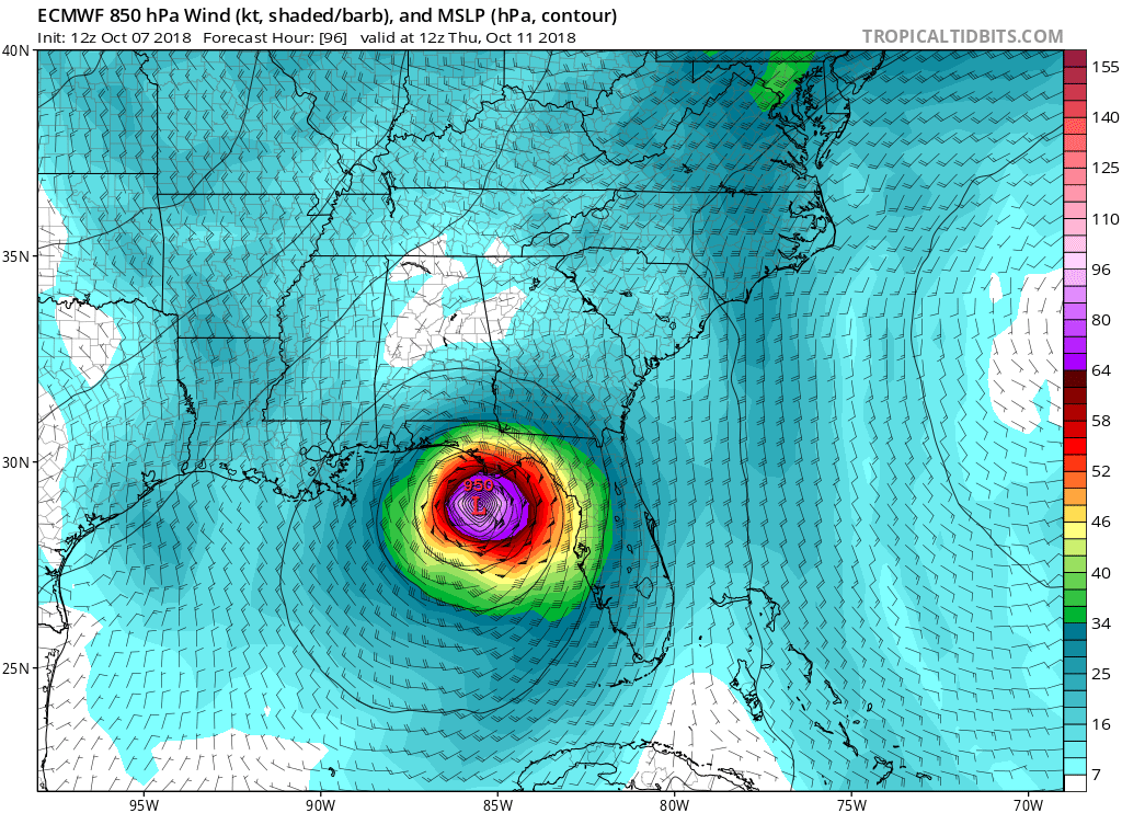
EURO and UKMET have Michael as a hurricane with 950 millibars.
UKMET
GFS
EURO and UKMET have Michael as a hurricane with 950 millibars.
Norma (1981), Paul (1982), Waldo (1985), Paine (1986), Roslyn (1986), Rosa (1994), Madeline (1998), Norman (2012), Odile (2014), and Patricia (2015) come to mind.Cpv17 wrote:Sometimes these EPAC storms can cause copious amounts of rainfall in Texas when they go into Mexico like that so it’s just something to keep an eye on.DoctorMu wrote:Yeah, a dreary mid level moisture weekend on tap in a week. A real shame, because Friday's front would have been pretty bone dry otherwise.srainhoutx wrote:EPAC Hurricane Sergio and its remnants likely will be a wildcard regarding our sensible weather next weekend as it merges with that Fall Cold Front. Over running clouds and possibly mid/upper level moisture and strong fronts can lead to rainfall after the front passes giving us cool and gloomy weather we often see in Fall and in Winter.
Sergio is currently a major EPAC fish storm poised to take a turn NE and weaken. It certainly would be posed to ruin next weekend's BBQs and other outdoor activities.
https://www.nhc.noaa.gov/graphics_ep1.s ... e#contents
Go away.
-
srainhoutx
- Site Admin
- Posts: 19616
- Joined: Tue Feb 02, 2010 2:32 pm
- Location: Maggie Valley, NC
- Contact:
I continue to see a growing consensus that cooler weather is indeed on the way. The first modified front should arrive Wednesday with a much stronger surge of cooler air arriving next weekend. In fact the week of the 15th through the 20th looks more and more like the "typical" Texas Fall Chamber of Commerce weather we get many years in mid October. Temperatures in the upper 40's to low 50's with highs ranging from the upper 60's to low 70's. The fly in the ointment will be Sergio in the Eastern Pacific as it quickly re-curves into the Baja Peninsula and Northern Mexico late this coming work week.
- Attachments
-
-
Carla/Alicia/Jerry(In The Eye)/Michelle/Charley/Ivan/Dennis/Katrina/Rita/Wilma/Humberto/Ike/Harvey
Member: National Weather Association
Facebook.com/Weather Infinity
Twitter @WeatherInfinity
Member: National Weather Association
Facebook.com/Weather Infinity
Twitter @WeatherInfinity
Ptarmigan wrote:Norma (1981), Paul (1982), Waldo (1985), Paine (1986), Roslyn (1986), Rosa (1994), Madeline (1998), Norman (2012), Odile (2014), and Patricia (2015) come to mind.Cpv17 wrote:Sometimes these EPAC storms can cause copious amounts of rainfall in Texas when they go into Mexico like that so it’s just something to keep an eye on.DoctorMu wrote: Yeah, a dreary mid level moisture weekend on tap in a week. A real shame, because Friday's front would have been pretty bone dry otherwise.
Sergio is currently a major EPAC fish storm poised to take a turn NE and weaken. It certainly would be posed to ruin next weekend's BBQs and other outdoor activities.
https://www.nhc.noaa.gov/graphics_ep1.s ... e#contents
Go away.
Rosa remnants dumped 18 inches of rain on CLL in less than 18 hours. I had to kick down the fence to let water out of the backyard.
The GFS now keeps most of the Sergio moisture and rain west of us now. Fingers crossed, and a watchful eye.DoctorMu wrote:Hmmm...I'm salivating for a potential week of NW flow and a crisp weekend. It may be just the front. Don't mess this up!Cpv17 wrote:I don’t really know what to think of it, but kind of out of nowhere the 12z GFS has a lot of rain for western parts of the viewing area next weekend.
I see it now - the fly in the ointment is moisture from a Pacific hurricane that lands ashore in Mexico. haha It will probably evaporate in the next GFS run! Having said that I noticed the Euro brings the storm ashore on the same spot in the Baja Peninsula.
At least I enjoyed a few more days of green grass. However, 4 inches from rain in a week washed away the fungicide and with a damp soil the brown patch has started already...and without even any cool nights yet. Put down another bolus of fungicide this am. Texas lawn and gardening - it is not for the weak of heart!

-
TexasMetBlake
- Pro Met

- Posts: 839
- Joined: Wed Feb 03, 2010 7:03 pm
- Location: Spring/Woodlands
- Contact:
Good afternoon, y'all! Well we've certainly gotten off to a rough start as far as the fall weather goes but if the latest 12z Euro has anything to say about it, Mother Nature may very well be sending us an apology front.
Check out the forecast high temps at hour 204.
There are a few reasons why I think this is bogus, first of which is the record low high records. For the 16th, the record low max is 66 degrees in 1906. It would be nearly unprecedented to shatter a low max, or any record, by 10 degrees.
Second, while there is some ensemble support, anecdotally speaking, I can't remember the last time it was that chilly in mid October. Having a 1041 mb high over the Rockies seems rather robust.
Of course this entire scenario will be hinged on the movement of Sergio. The latest synoptic read from the Euro is that the remnants of the hurricane could make a move right over us making for a very wet, raw, chilly Sunday/Monday. The GFS on the other hand is much warmer and drier as the remnants of Sergio move into the midwest. Lots to follow.
Regardless if any records are challenged or not, it certainly seems like Autumn will be setting up shop here in a matter of days and not a moment too soon.

I remember Oct 8-9 2000 had a high of 50 and 53 and was mostly in the 40's all day. Just one month of record breaking heat the month before making the 40's feel very cold.
https://www.weather.gov/media/hgx/clima ... 010IAH.pdf
https://www.weather.gov/media/hgx/clima ... 010IAH.pdf
-
Texaspirate11

- Posts: 1278
- Joined: Tue Dec 31, 2013 12:24 am
- Contact:
i know minneapolis is under a flood warning...i guess due to sergio....
Just because you're disabled, you don't have to be a victim
Be Weather Aware & Prepared!
Barbara Jordan Winner in Media
Disability Integration Consultant
Be Weather Aware & Prepared!
Barbara Jordan Winner in Media
Disability Integration Consultant
-
srainhoutx
- Site Admin
- Posts: 19616
- Joined: Tue Feb 02, 2010 2:32 pm
- Location: Maggie Valley, NC
- Contact:
Sergio is well out in the Eastern Pacific almost half way between Mexico and Hawaii. The moisture plume and flooding rain across the Plains into the Great Lakes is a combination of much drier and cooler air to the West over the Great Basin and very deep tropical moisture streaming out of the Gulf and the Eastern Pacific. Now this weekend we likely will see Sergio moisture entrained along and ahead for that strong Fall Front. Additional flooding across portions of New Mexico and Texas particularly from the Big Bend to Permian Basin to the Rio Grande Valley may be possible.
Everything is on track for a Pacific front to arrive Wednesday and usher in some drier air as potential Major Hurricane Michael near the NE Gulf Coast. The overnight guidance continues with the idea of that strong Fall Front arriving this weekend. Timing remains to be seen as well as whether we clear out behind that strong front. The morning WPC Surface Charts and QPF suggest the Fall Front will be diving S out of the Southern Plains into Texas Saturday night/Sunday morning with showers and storms likely. Some of the guidance suggest upglide lift with light rain/drizzle may be possible after the front clears the Coast.
Carla/Alicia/Jerry(In The Eye)/Michelle/Charley/Ivan/Dennis/Katrina/Rita/Wilma/Humberto/Ike/Harvey
Member: National Weather Association
Facebook.com/Weather Infinity
Twitter @WeatherInfinity
Member: National Weather Association
Facebook.com/Weather Infinity
Twitter @WeatherInfinity
-
srainhoutx
- Site Admin
- Posts: 19616
- Joined: Tue Feb 02, 2010 2:32 pm
- Location: Maggie Valley, NC
- Contact:
Monday morning briefing from Jeff for TS Michael:
Significant hurricane event increasingly likely for the FL panhandle
Hurricane Watches are issued from the Alabama/Florida state line to the Suwannee River, FL
Storm Surge Watch is issued from Tampa Bay to Navarre Beach, FL including all of Tampa Bay.
Discussion:
Michael has continued to intensify in the last 24 hours with the central pressure now down to 982mb and maximum winds to near 70mph. Recent aircraft fixes indicate that the intensification process appears to have leveled off with no significant pressure falls in the last few passes of the aircraft. Deep convection continues to attempt to consolidate around the center, but westerly wind shear over Michael is resulting in some displacement of the center on the west side of the convection. Michael is starting to move a little faster toward the north at 7mph.
Track:
Michael is slowly becoming entrained in the steering pattern from south to north with high pressure over the eastern US and low pressure over the central US. Michael will move generally northward for the next 48 hours and then turn toward the NE as the system approaches the US coast. How fast the NE turns transpires before landfall will ultimately determine the landfall location. Track guidance is tightly clustered on this solution and a landfall of a potentially major hurricane into the FL panhandle on Wednesday is increasingly likely. The forward speed of Michael over the eastern Gulf of Mexico over the next 48-72 hours is one item that track guidance is not in great agreement with the ECWMF nearly a full 24 hours slower with Michael and allows a very strong hurricane (sub 940mb) to strike the FL panhandle. The slower guidance allows Michael to be over the very warm Gulf of Mexico an additional 18-24 hours leading to a stronger landfalling hurricane.
Intensity:
Michael is defying the westerly wind shear and has continued to intensify, although the inner core of the system is not overly well defined per both aircraft observations and satellite images. Michael will be moving over the very warm Gulf Loop current over the next 24-48 hours where historically hurricanes have shown extensive deepening. Additionally, the upper level conditions will become increasingly favorable for intensification as Michael moves northward over the Gulf of Mexico. As the forward speed of the system increases, this will help, to some degree negate the SW shear over the system. There continues to be significant spread in the intensity guidance and the current NHC forecast brings Michael to the FL panhandle as a strong category 2 hurricane. It is becoming increasingly likely that Michael will landfall as a major hurricane (category 3 or higher). Early October Gulf hurricanes with this type of upper air pattern setup have in the past developed very quickly and based on the organization of Michael this morning rapid intensification over the Gulf of Mexico appears at least a good possibility.
Michael has a large wind field with TS force winds extending outward nearly 175 miles from the center. Michael is forecast to be a fairly large hurricane as it moves northward over the Gulf of Mexico. Large hurricanes on this sort of track toward the FL panhandle will push a massive storm surge into the FL Big Bend area which is extremely vulnerable to storm surge.
Impacts:
A significant hurricane event is now likely on the FL panhandle coast on Wednesday
Destructive winds well over 100mph will be likely near the landfall location and then hurricane force winds spreading far inland as the forward speed of the system will be increasing.
Life threatening storm surge over a very large area is becoming increasingly likely from east of Pensacola to north of Tampa Bay. Storm surge is likely the greatest threat at the moment from Michael as a hurricane approach on this angle into the FL panhandle/Big Bend area will drive a very high storm surge into many areas.
Since Michael will be accelerating after landfall, rainfall mounts should average 5-10 inches, but the system will move over portions of the Carolinas hard hit by Florence and some rivers have just recently fallen below flood stage from the Florence flooding, so additional very heavy rainfall in those areas will likely lead to renewed flooding.
- Attachments
-
-
-
Carla/Alicia/Jerry(In The Eye)/Michelle/Charley/Ivan/Dennis/Katrina/Rita/Wilma/Humberto/Ike/Harvey
Member: National Weather Association
Facebook.com/Weather Infinity
Twitter @WeatherInfinity
Member: National Weather Association
Facebook.com/Weather Infinity
Twitter @WeatherInfinity
-
srainhoutx
- Site Admin
- Posts: 19616
- Joined: Tue Feb 02, 2010 2:32 pm
- Location: Maggie Valley, NC
- Contact:
Michael is now a Hurricane. Michael is expected to reach Major Hurricane status before landfall...
HURRICANE MICHAEL DISCUSSION NUMBER 8
NWS NATIONAL HURRICANE CENTER MIAMI FL AL142018
1100 AM EDT MON OCT 08 2018
THE SATELLITE PRESENTATION OF MICHAEL HAS CONTINUED TO IMPROVE
OVERNIGHT AND THIS MORNING, WITH THE CENTER WELL EMBEDDED WITHIN AN
AREA OF COLD CLOUD TOPS. AN EYE IS BECOMING APPARENT IN VISIBLE
IMAGERY, AND THIS WAS ALSO CONFIRMED BY A RECENT SSMIS MICROWAVE
OVERPASS AND THE AIR FORCE RESERVE RECONNAISSANCE AIRCRAFT. THE
AIRCRAFT REPORTED A MINIMUM PRESSURE AROUND 982 MB DURING THE MOST
RECENT PASS THROUGH THE CENTER, AND ALSO FOUND FLIGHT-LEVEL
WINDS THAT SUPPORT UPGRADING MICHAEL TO A A 65-KT HURRICANE FOR THIS
ADVISORY.
ALTHOUGH THE OUTFLOW IS STILL SOMEWHAT RESTRICTED OVER THE WESTERN
PORTION OF THE CIRCULATION, IT HAS BEEN EXPANDING IN THAT
DIRECTION. THE GLOBAL MODELS SUGGEST THAT THE SHEAR WILL RELAX A
LITTLE MORE WHILE THE HURRICANE MOVES OVER THE VERY WARM WATERS OF
THE SOUTHEASTERN GULF OF MEXICO. NOW THAT MICHAEL HAS DEVELOPED AN
INNER CORE, STEADY TO RAPID STRENGTHENING IS PREDICTED DURING THE
NEXT 24 TO 36 HOURS. THE SHIPS RAPID INTENSIFICATION INDEX AND
DTOPS GIVE A 55-60 PERCENT CHANCE OF RAPID INTENSIFICATION DURING
THE NEXT 24 HOURS. THE UPDATED NHC FORECAST IS NEAR THE UPPER-END
OF THE GUIDANCE AND CALLS FOR RAPID STRENGTHENING OVER THE NEXT 24
HOURS, AND BRINGS MICHAEL TO MAJOR HURRICANE STATUS. AFTER
THAT TIME, MOST OF THE INTENSITY GUIDANCE SLOWS DOWN THE RATE OF
INTENSIFICATION, PERHAPS DUE TO A SLIGHT INCREASE IN SOUTHWESTERLY
SHEAR. WEAKENING IS EXPECTED AFTER LANDFALL, BUT THE FORECAST TRACK
KEEPS A PORTION OF THE CIRCULATION OVER WATER ALONG THE SOUTHEAST
U.S. COAST, SO MICHAEL IS PREDICTED TO REMAIN A TROPICAL STORM
THROUGH 72 HOURS. THE SYSTEM SHOULD BECOME A POWERFUL EXTRATROPICAL
LOW OFF THE U.S. MID-ATLANTIC COAST IN ABOUT 4 DAYS.
RECONNAISSANCE AIRCRAFT FIXES INDICATE THAT MICHAEL IS STILL MOVING
A LITTLE EAST OF DUE NORTH. THE HURRICANE SHOULD MOVE NORTHWARD OR
NORTH-NORTHWESTWARD OVER THE NEXT COUPLE OF DAYS WHILE THE STORM
CROSSES THE EASTERN GULF OF MEXICO. BY 48 HOURS, MICHAEL SHOULD
TURN NORTHEASTWARD AHEAD OF A TROUGH MOVING INTO THE CENTRAL
UNITED STATES. THE CROSS-TRACK SPREAD IN THE GUIDANCE HAS
DECREASED SINCE YESTERDAY, BUT THERE CONTINUE TO BE DIFFERENCES IN
HOW FAST MICHAEL MOVES NORTHWARD OVER THE GULF OF MEXICO. THE HWRF
AND GFS REMAIN AMONG THE FASTER MODELS, WHILE THE ECMWF IS STILL
MUCH SLOWER. THE NHC TRACK IS ALONG THE EASTERN SIDE OF THE
GUIDANCE THROUGH 24 HOURS DUE TO THE RECENT MOTION OF THE STORM,
AND IS REMAINS NEAR THE VARIOUS CONSENSUS AIDS AFTER THAT TIME. THE
POST-TROPICAL PORTION OF THE TRACK AND INTENSITY FORECAST IS BASED
ON GUIDANCE PROVIDED BY THE OCEAN PREDICTION CENTER.
KEY MESSAGES:
1. MICHAEL IS FORECAST TO BE A DANGEROUS MAJOR HURRICANE WHEN IT
REACHES THE NORTHEASTERN GULF COAST ON WEDNESDAY, AND LIFE-
THREATENING STORM SURGE IS POSSIBLE ALONG PORTIONS OF THE FLORIDA
GULF COAST REGARDLESS OF THE STORM'S EXACT TRACK OR INTENSITY.
RESIDENTS IN THE STORM SURGE AND HURRICANE WATCH AREAS SHOULD FOLLOW
ANY ADVICE GIVEN BY LOCAL OFFICIALS, AS STORM SURGE AND HURRICANE
WARNINGS WILL LIKELY BE ISSUED LATER TODAY.
2. HEAVY RAINFALL FROM MICHAEL COULD PRODUCE LIFE-THREATENING FLASH
FLOODING FROM THE FLORIDA PANHANDLE AND BIG BEND REGION INTO
PORTIONS OF THE CAROLINAS THROUGH THURSDAY.
3. HURRICANE CONDITIONS WILL SPREAD OVER PORTIONS OF WESTERN CUBA
THIS AFTERNOON, WHERE A HURRICANE WARNING IS NOW IN EFFECT.
TROPICAL STORM CONDITIONS ARE EXPECTED OVER THE NORTHEASTERN YUCATAN
PENINSULA AND THE ISLE OF YOUTH TODAY.
4. MICHAEL IS EXPECTED TO PRODUCE HEAVY RAINFALL AND FLASH FLOODING
OVER PORTIONS OF WESTERN CUBA AND THE NORTHEASTERN YUCATAN PENINSULA
OF MEXICO DURING THE NEXT COUPLE OF DAYS.
FORECAST POSITIONS AND MAX WINDS
INIT 08/1500Z 21.2N 84.9W 65 KT 75 MPH
12H 09/0000Z 22.6N 85.3W 85 KT 100 MPH
24H 09/1200Z 24.4N 85.9W 95 KT 110 MPH
36H 10/0000Z 26.4N 86.4W 105 KT 120 MPH
48H 10/1200Z 28.6N 86.1W 105 KT 120 MPH
72H 11/1200Z 33.0N 82.5W 45 KT 50 MPH...INLAND
96H 12/1200Z 37.8N 73.6W 50 KT 60 MPH...POST-TROP/EXTRATROP
120H 13/1200Z 42.8N 59.0W 55 KT 65 MPH...POST-TROP/EXTRATROP
$$
FORECASTER BROWN
- Attachments
-
Carla/Alicia/Jerry(In The Eye)/Michelle/Charley/Ivan/Dennis/Katrina/Rita/Wilma/Humberto/Ike/Harvey
Member: National Weather Association
Facebook.com/Weather Infinity
Twitter @WeatherInfinity
Member: National Weather Association
Facebook.com/Weather Infinity
Twitter @WeatherInfinity
-
- Information
-
Who is online
Users browsing this forum: Ahrefs [Bot], Amazon [Bot], Bing [Bot] and 90 guests