
April 2018- April To End Cooler/Drier Than Normal
-
tireman4

- Global Moderator

- Posts: 4470
- Joined: Wed Feb 03, 2010 9:24 pm
- Location: Humble, Texas
- Contact:
Bolding to what Srain alluded to in his morning AFD
000
FXUS64 KHGX 031550
AFDHGX
Area Forecast Discussion
National Weather Service Houston/Galveston TX
1050 AM CDT Tue Apr 3 2018
.DISCUSSION...
SPC has issued Severe Thunderstorm Watch Number 25, in effect for
Brazos, Burleson, Houston, Madison and Trinity counties until 6 PM.
Thunderstorms have developed to the west of our northern counties,
and activity is expected to spread northeastward for the rest of
the morning and into the afternoon hours. Some of our northern
counties (in and near the Watch area) have a risk of seeing strong/
severe thunderstorm development mainly this afternoon with activity
spreading to the east and eventually off to the southeast as the
afternoon/evening progresses. Large hail and strong damaging winds
are the primary severe weather threat. Additional watches might
be needed later today depending on how things evolve. 42
&&
-
tireman4
- Global Moderator
- Posts: 4470
- Joined: Wed Feb 03, 2010 9:24 pm
- Location: Humble, Texas
- Contact:
Dr. Greg Forbes
49 mins ·
It is going to be an active spring day of severe thunderstorms from TX and LA to the Midwest. NWS/SPC has issued a severe thunderstorm watch for parts of northeast TX and bits of adjacent states until 6PM (2.5" hail, 70 mph gusts)
http://www.spc.noaa.gov/products/watch/ ... ar_big.gif
49 mins ·
It is going to be an active spring day of severe thunderstorms from TX and LA to the Midwest. NWS/SPC has issued a severe thunderstorm watch for parts of northeast TX and bits of adjacent states until 6PM (2.5" hail, 70 mph gusts)
http://www.spc.noaa.gov/products/watch/ ... ar_big.gif
-
srainhoutx

- Site Admin

- Posts: 19615
- Joined: Tue Feb 02, 2010 2:32 pm
- Location: Maggie Valley, NC
- Contact:
We'll need to monitor the cluster of thunderstorms over Central Texas. HGX is closely watching to see if the cluster grows into a larger thunderstorm complex which could lead to potential issues in Metro Houston later this evening. GOES 16 Visible and Water Vapor Imagery detect a swiftly moving frontal boundary across the Permian Basin and N Texas to the S of Ft Worth/Dallas. Texas A&M will do a special balloon launch around 2:30 PM to further access the atmosphere. If the front moves in quicker and the disturbance (shortwave) currently over Mexico converge near SE Texas, the risk may increase. Currently the thinking is things will somewhat diminish after sunset. Keep an eye on the radars and for any additional trends later this afternoon.
Carla/Alicia/Jerry(In The Eye)/Michelle/Charley/Ivan/Dennis/Katrina/Rita/Wilma/Humberto/Ike/Harvey
Member: National Weather Association
Facebook.com/Weather Infinity
Twitter @WeatherInfinity
Member: National Weather Association
Facebook.com/Weather Infinity
Twitter @WeatherInfinity

LOcal met in bmt was saying less than an inch for most areas. Has anything changed to make it higher amts? Last storm models projected about 1” for my area and we ended up with 5” and major flooding around town. Thanks in advance...
Mike
Beaumont, TX
(IH-10 & College Street)
Beaumont, TX
(IH-10 & College Street)
-
redneckweather
- Posts: 1022
- Joined: Mon Feb 08, 2010 7:29 pm
- Location: Montgomery, Texas
- Contact:
The cluster of storms off to our North look to stay out of our area. In fact, I don't see much of anything with the actual frontal passage either later on. Nice chamber of commerce weather over the next couple of days.

Have you looked at a water vapor loop of the shortwave in Mexico that is racing in this direction, about to collide with the front coming from the north? The cluster to the north is just a teaser...redneckweather wrote:The cluster of storms off to our North look to stay out of our area. In fact, I don't see much of anything with the actual frontal passage either later on. Nice chamber of commerce weather over the next couple of days.

The storms off to our north should generally move eastward the next couple hours. As the front to our north begins to push south towards us this evening, those storms will leave boundaries in place and new convection will fire along the cold front up around Dallas and intensify as it moves into a very unstable, juiced environment here in SE TX. There isn't a model I've seen that shows the front coming in dry.redneckweather wrote:The cluster of storms off to our North look to stay out of our area. In fact, I don't see much of anything with the actual frontal passage either later on. Nice chamber of commerce weather over the next couple of days.
As Steve alluded to, the shortwave over Mexico and the frontal passage will be key in just the amount of activity and severity of these storms this evening. I'm confident that a line of storms will move through after 10pm with the front and leave generally an .75 to an inch of rain across the area... with some areas maybe having slightly higher totals.
Blake
Boomer Sooner
Boomer Sooner
-
tireman4
- Global Moderator
- Posts: 4470
- Joined: Wed Feb 03, 2010 9:24 pm
- Location: Humble, Texas
- Contact:
Belmer is spot on with his assessment. This was supposed to be a quick mover, so flooding was never an issue. Remember, many of our staff will be at the Tropical Weather Conference ( Jeff, Wxman 57, Katdaddy, Srain to name a few)...so thank you to the mets that are manning the boards ( Belmer and Andrew). This will be an interesting event coming up.Belmer wrote:The storms off to our north should generally move eastward the next couple hours. As the front to our north begins to push south towards us this evening, those storms will leave boundaries in place and new convection will fire along the cold front up around Dallas and intensify as it moves into a very unstable, juiced environment here in SE TX. There isn't a model I've seen that shows the front coming in dry.redneckweather wrote:The cluster of storms off to our North look to stay out of our area. In fact, I don't see much of anything with the actual frontal passage either later on. Nice chamber of commerce weather over the next couple of days.
As Steve alluded to, the shortwave over Mexico and the frontal passage will be key in just the amount of activity and severity of these storms this evening. I'm confident that a line of storms will move through after 10pm with the front and leave generally an .75 to an inch of rain across the area... with some areas maybe having slightly higher totals.
First signs of storms popping now along the front in Collin, Denton, Grayson Counties, just north of the DFW Metroplex.
-
tireman4
- Global Moderator
- Posts: 4470
- Joined: Wed Feb 03, 2010 9:24 pm
- Location: Humble, Texas
- Contact:
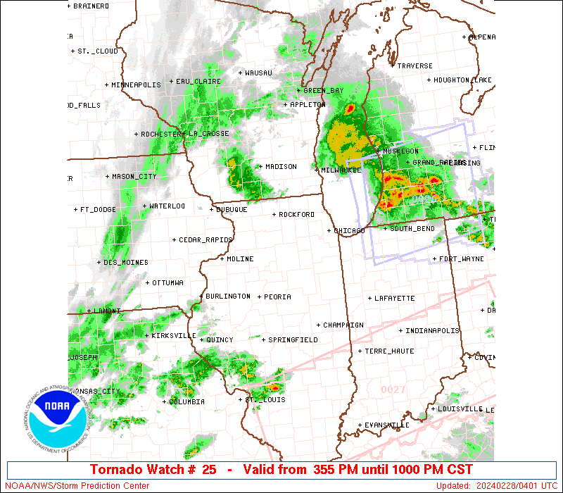
As Jason stated, the juices are starting to flow...
SEL6
URGENT - IMMEDIATE BROADCAST REQUESTED
Tornado Watch Number 26
NWS Storm Prediction Center Norman OK
115 PM EDT Tue Apr 3 2018
The NWS Storm Prediction Center has issued a
* Tornado Watch for portions of
Southern and Central Indiana
Northern Kentucky
Western and Central Ohio
* Effective this Tuesday afternoon and evening from 115 PM until
800 PM EDT.
* Primary threats include...
A few tornadoes likely with a couple intense tornadoes possible
Scattered damaging wind gusts to 70 mph likely
Scattered large hail and isolated very large hail events to 2
inches in diameter possible
SUMMARY...Thunderstorms are intensifying along the IL/IN border, and
will track eastward across the watch area through the afternoon.
Conditions appear favorable for supercell storms capable of large
hail, damaging winds, and perhaps a strong tornado or two.
The tornado watch area is approximately along and 70 statute miles
north and south of a line from 40 miles south southwest of Terre
Haute IN to 20 miles south southeast of Columbus OH. For a complete
depiction of the watch see the associated watch outline update
(WOUS64 KWNS WOU6).
PRECAUTIONARY/PREPAREDNESS ACTIONS...
REMEMBER...A Tornado Watch means conditions are favorable for
tornadoes and severe thunderstorms in and close to the watch
area. Persons in these areas should be on the lookout for
threatening weather conditions and listen for later statements
and possible warnings.
&&
OTHER WATCH INFORMATION...CONTINUE...WW 25...
AVIATION...Tornadoes and a few severe thunderstorms with hail
surface and aloft to 2 inches. Extreme turbulence and surface wind
gusts to 60 knots. A few cumulonimbi with maximum tops to 450. Mean
storm motion vector 24035.
...Hart
-
tireman4
- Global Moderator
- Posts: 4470
- Joined: Wed Feb 03, 2010 9:24 pm
- Location: Humble, Texas
- Contact:
NWS Fort Worth
@NWSFortWorth
26 seconds ago
More
1:30 pm - Dime size hail and winds in excess of 40 mph are possible with a strong thunderstorm 11 miles SE of Fairfield Lake State Park. This storm is moving east at 60 mph. #txwx
@NWSFortWorth
26 seconds ago
More
1:30 pm - Dime size hail and winds in excess of 40 mph are possible with a strong thunderstorm 11 miles SE of Fairfield Lake State Park. This storm is moving east at 60 mph. #txwx
The line along the front is just exploding as it crosses the Metroplex.
Severe Thunderstorm Warning
TXC073-347-401-423-032045-
/O.NEW.KSHV.SV.W.0047.180403T1948Z-180403T2045Z/
BULLETIN - IMMEDIATE BROADCAST REQUESTED
Severe Thunderstorm Warning
National Weather Service Shreveport LA
248 PM CDT TUE APR 3 2018
The National Weather Service in Shreveport has issued a
* Severe Thunderstorm Warning for...
Southeastern Smith County in northeastern Texas...
Rusk County in northeastern Texas...
Northwestern Nacogdoches County in eastern Texas...
Cherokee County in northeastern Texas...
* Until 345 PM CDT
* At 247 PM CDT, a severe thunderstorm was located near Maydelle, or
near Rusk, moving northeast at 60 mph.
HAZARD...60 mph wind gusts and quarter size hail.
SOURCE...Radar indicated.
IMPACT...Hail damage to vehicles is expected. Expect wind damage
to roofs, siding, and trees.
* Locations impacted include...
Jacksonville, Henderson, Rusk, Overton, Troup, Alto, New London,
Arp, Ponta, New Salem, Trawick, Mount Selman, Joinerville, Sacul,
Mixon, Turnertown, Minden, Maydelle, New Summerfield and Cushing.
PRECAUTIONARY/PREPAREDNESS ACTIONS...
For your protection move to an interior room on the lowest floor of a
building.
&&
LAT...LON 3237 9485 3176 9447 3160 9527 3162 9526
3163 9529 3166 9528 3168 9529 3172 9534
3174 9533 3173 9537 3175 9536 3176 9540
3182 9540 3185 9544 3188 9543 3190 9544
3193 9542 3196 9545
TIME...MOT...LOC 1947Z 247DEG 58KT 3180 9524
HAIL...1.00IN
WIND...60MPH
$$
05
-
brooksgarner

- Global Moderator
- Posts: 226
- Joined: Tue Jun 04, 2013 3:06 pm
- Location: Houston, TX
- Contact:
What's up, guys. Watching this shortwave being ejected into Texas from Mexico, where there's very little upper level data for the models to process. It may provide, "unexpected" energy and dynamics for the late evening storms. Not sure if models are advertising this as much as it may become.... As of now the majority of the severe weather looks to focus far northeast of the Houston region but we're watching carefully. -Brooks
Broadcast Met
http://BrooksGarner.com
http://twitter.com/BrooksWeather
http://BrooksGarner.com
http://twitter.com/BrooksWeather
- '17 Harvey
- '12 Sandy (P3 Orion)
- '91 Bob
- '85 Gloria
That was the same IR channel I was looking at earlier 
Anyway, Jeff sent an email at 4:02 and throws a little bit of cold water on things:
Anyway, Jeff sent an email at 4:02 and throws a little bit of cold water on things:
A slight risk of severe weather remains for late this afternoon into the evening hours.
200pm sounding from UH shows a fairly capped air mass remains in place over much of SE TX while this cap weakens toward the north. Thus far nothing has been able to break the cap and it is looking increasing likely that we will have to await the arrival of the surface front well back to the NW near Waco to move into the area to break the cap and develop thunderstorms. Shear and instability parameters remain in place so as the front moves southeastward expect a line of thunderstorms to gradually fill in along the boundary. Main threats will be damaging winds and large hail. Short range guidance shows this line starting to weaken and break into line segments as it near I-10 late this evening likely due to surface cooling so the severe threat is more marginal the further south you are over the region.